
Scheldt
Encyclopedia
River
A river is a natural watercourse, usually freshwater, flowing towards an ocean, a lake, a sea, or another river. In a few cases, a river simply flows into the ground or dries up completely before reaching another body of water. Small rivers may also be called by several other names, including...
in northern France
France
The French Republic , The French Republic , The French Republic , (commonly known as France , is a unitary semi-presidential republic in Western Europe with several overseas territories and islands located on other continents and in the Indian, Pacific, and Atlantic oceans. Metropolitan France...
, western Belgium
Belgium
Belgium , officially the Kingdom of Belgium, is a federal state in Western Europe. It is a founding member of the European Union and hosts the EU's headquarters, and those of several other major international organisations such as NATO.Belgium is also a member of, or affiliated to, many...
and the southwestern part of the Netherlands
Netherlands
The Netherlands is a constituent country of the Kingdom of the Netherlands, located mainly in North-West Europe and with several islands in the Caribbean. Mainland Netherlands borders the North Sea to the north and west, Belgium to the south, and Germany to the east, and shares maritime borders...
. Its name is derived from an adjective corresponding to Old English sceald "shallow", Modern English
English language
English is a West Germanic language that arose in the Anglo-Saxon kingdoms of England and spread into what was to become south-east Scotland under the influence of the Anglian medieval kingdom of Northumbria...
shoal, Low German
Low German
Low German or Low Saxon is an Ingvaeonic West Germanic language spoken mainly in northern Germany and the eastern part of the Netherlands...
schol, Frisian skol, and Swedish
Swedish language
Swedish is a North Germanic language, spoken by approximately 10 million people, predominantly in Sweden and parts of Finland, especially along its coast and on the Åland islands. It is largely mutually intelligible with Norwegian and Danish...
skäll "thin".
Course
The headwaters of the Scheldt are in GouyGouy
Gouy may refer to:* the following communes in France:** Gouy, Aisne, in the department of Aisne** Gouy, Seine-Maritime, in the department of Seine-Maritime** Gouy-en-Artois, in the department of Pas-de-Calais...
, in the Aisne
Aisne
Aisne is a department in the northern part of France named after the Aisne River.- History :Aisne is one of the original 83 departments created during the French Revolution on 4 March 1790. It was created from parts of the former provinces of Île-de-France, Picardie, and Champagne.Most of the old...
department of northern France
France
The French Republic , The French Republic , The French Republic , (commonly known as France , is a unitary semi-presidential republic in Western Europe with several overseas territories and islands located on other continents and in the Indian, Pacific, and Atlantic oceans. Metropolitan France...
. It flows north through Cambrai
Cambrai
Cambrai is a commune in the Nord department in northern France. It is a sub-prefecture of the department.Cambrai is the seat of an archdiocese whose jurisdiction was immense during the Middle Ages. The territory of the Bishopric of Cambrai, roughly coinciding with the shire of Brabant, included...
and Valenciennes
Valenciennes
Valenciennes is a commune in the Nord department in northern France.It lies on the Scheldt river. Although the city and region had seen a steady decline between 1975 and 1990, it has since rebounded...
, and enters Belgium
Belgium
Belgium , officially the Kingdom of Belgium, is a federal state in Western Europe. It is a founding member of the European Union and hosts the EU's headquarters, and those of several other major international organisations such as NATO.Belgium is also a member of, or affiliated to, many...
near Tournai
Tournai
Tournai is a Walloon city and municipality of Belgium located 85 kilometres southwest of Brussels, on the river Scheldt, in the province of Hainaut....
. In Ghent
Ghent
Ghent is a city and a municipality located in the Flemish region of Belgium. It is the capital and biggest city of the East Flanders province. The city started as a settlement at the confluence of the Rivers Scheldt and Lys and in the Middle Ages became one of the largest and richest cities of...
, where it receives the Lys
Lys River
The Leie or Lys is a river in France and Belgium, and a left tributary of the Scheldt. Its source is in Pas-de-Calais, France, and it flows into the river Scheldt in Ghent, Belgium. Its total length is ....
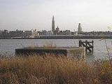
, one of its main tributaries, the Scheldt turns east. Near Antwerp, the largest city on its banks, the Scheldt flows west into the Netherlands
Netherlands
The Netherlands is a constituent country of the Kingdom of the Netherlands, located mainly in North-West Europe and with several islands in the Caribbean. Mainland Netherlands borders the North Sea to the north and west, Belgium to the south, and Germany to the east, and shares maritime borders...
towards the North Sea
North Sea
In the southwest, beyond the Straits of Dover, the North Sea becomes the English Channel connecting to the Atlantic Ocean. In the east, it connects to the Baltic Sea via the Skagerrak and Kattegat, narrow straits that separate Denmark from Norway and Sweden respectively...
.
Originally there were two branches from that point: the Oosterschelde
Oosterschelde
The Oosterschelde is an estuary in Zeeland, Netherlands, between Schouwen-Duiveland and Tholen on the north and Noord-Beveland and Zuid-Beveland on the south.During the Roman Era it was the major mouth of the Scheldt River. Before the St...
(Eastern Scheldt) and the Westerschelde (Western Scheldt) but in the 19th century the river was cut off from its eastern (actually: northern) branch by a dyke that connects Zuid-Beveland
Zuid-Beveland
Zuid-Beveland is a part of the province of Zeeland in the Netherlands north of the Westerschelde and south of the Oosterschelde. It is a former island, now peninsula, crossed by the Canal through Zuid-Beveland on the west and the Scheldt-Rhine Canal on the east.It consists of four...
with the mainland (North Brabant
North Brabant
North Brabant , sometimes called Brabant, is a province of the Netherlands, located in the south of the country, bordered by Belgium in the south, the Meuse River in the north, Limburg in the east and Zeeland in the west.- History :...
). Today the river therefore continues into the Westerschelde estuary
Estuary
An estuary is a partly enclosed coastal body of water with one or more rivers or streams flowing into it, and with a free connection to the open sea....
only, passing Terneuzen
Terneuzen
Terneuzen is a city and municipality in the southwestern Netherlands, in the province of Zeeland, in the middle of Zeelandic Flanders. With over 55,000 inhabitants, it is the most populous municipality of Zeeland.-Population centres :...
to reach the North Sea between Breskens
Breskens
Breskens is a harbour town on the Westerschelde in the municipality of Sluis in the province of Zeeland, in the south-western Netherlands. Its population is 4,280 ....
in Zeeuws-Vlaanderen
Zeeuws-Vlaanderen
Zeelandic Flanders is the southernmost region of the province of Zeeland in south-western Netherlands. It lies south of the Western Scheldt that separates the region from the remainder of Zeeland to the north...
and Vlissingen (Flushing) on Walcheren
Walcheren
thumb|right|250px|Campveer Tower in Veere, built in 1500Walcheren is a former island in the province of Zeeland in the Netherlands at the mouth of the Scheldt estuary. It lies between the Oosterschelde in the north and the Westerschelde in the south and is roughly the shape of a rhombus...
.
The Scheldt is an important waterway
Waterway
A waterway is any navigable body of water. Waterways can include rivers, lakes, seas, oceans, and canals. In order for a waterway to be navigable, it must meet several criteria:...
, and has been made navigable from its mouth up to Cambrai. The port of Antwerp
Port of Antwerp
The port of Antwerp, in Belgium, is a port in the heart of Europe accessible to capesize ships. Antwerp stands at the upper end of the tidal estuary of the Scheldt. The estuary is navigable by ships of more than 100,000 Gross Tons as far as 80 km inland. The inland location means that the port...
, the second largest in Europe, lies on its banks. Several canal
Canal
Canals are man-made channels for water. There are two types of canal:#Waterways: navigable transportation canals used for carrying ships and boats shipping goods and conveying people, further subdivided into two kinds:...
s (including the Albert Canal
Albert Canal
The Albert Canal is a canal located in northeastern Belgium, named after King Albert I of Belgium. It connects the major cities Antwerp and Liège and the Meuse and Scheldt rivers. It has a depth of , a free height of and a total length of...
) connect the Scheldt with the basins of the Rhine, Meuse
Meuse River
The Maas or Meuse is a major European river, rising in France and flowing through Belgium and the Netherlands before draining into the North Sea...
and Seine
Seine
The Seine is a -long river and an important commercial waterway within the Paris Basin in the north of France. It rises at Saint-Seine near Dijon in northeastern France in the Langres plateau, flowing through Paris and into the English Channel at Le Havre . It is navigable by ocean-going vessels...
, and with the industrial areas around Brussels
Brussels
Brussels , officially the Brussels Region or Brussels-Capital Region , is the capital of Belgium and the de facto capital of the European Union...
, Liège, Lille
Lille
Lille is a city in northern France . It is the principal city of the Lille Métropole, the fourth-largest metropolitan area in the country behind those of Paris, Lyon and Marseille. Lille is situated on the Deûle River, near France's border with Belgium...
, Dunkirk and Mons
Mons
Mons is a Walloon city and municipality located in the Belgian province of Hainaut, of which it is the capital. The Mons municipality includes the old communes of Cuesmes, Flénu, Ghlin, Hyon, Nimy, Obourg, Baudour , Jemappes, Ciply, Harmignies, Harveng, Havré, Maisières, Mesvin, Nouvelles,...
.
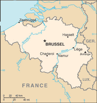
The Scheldt flows through the following departments of France, provinces of Belgium
Provinces of Belgium
Belgium is divided into three regions, two of them are subdivided into five provinces each.The division into provinces is fixed by Article 5 of the Belgian Constitution...
, provinces of the Netherlands
Provinces of the Netherlands
A Dutch province represents the administrative layer in between the national government and the local municipalities, having the responsibility for matters of subnational or regional importance. The government of each province consists of three major parts: the Provinciale Staten which is the...
and towns:
- AisneAisneAisne is a department in the northern part of France named after the Aisne River.- History :Aisne is one of the original 83 departments created during the French Revolution on 4 March 1790. It was created from parts of the former provinces of Île-de-France, Picardie, and Champagne.Most of the old...
(F): GouyGouyGouy may refer to:* the following communes in France:** Gouy, Aisne, in the department of Aisne** Gouy, Seine-Maritime, in the department of Seine-Maritime** Gouy-en-Artois, in the department of Pas-de-Calais... - Nord (F): CambraiCambraiCambrai is a commune in the Nord department in northern France. It is a sub-prefecture of the department.Cambrai is the seat of an archdiocese whose jurisdiction was immense during the Middle Ages. The territory of the Bishopric of Cambrai, roughly coinciding with the shire of Brabant, included...
, DenainDenainIt is the largest of 39 communes which comprise the association of communes of Porte du Hainaut, with a total population of 147,989, as of 1999. Denain had a population of 20,360, on a land area of 11.52 km² .-References:* -External links:...
, ValenciennesValenciennesValenciennes is a commune in the Nord department in northern France.It lies on the Scheldt river. Although the city and region had seen a steady decline between 1975 and 1990, it has since rebounded... - Hainaut (B): TournaiTournaiTournai is a Walloon city and municipality of Belgium located 85 kilometres southwest of Brussels, on the river Scheldt, in the province of Hainaut....
- West Flanders (B): AvelgemAvelgemAvelgem is a municipality located in the Belgian province of West Flanders. The municipality comprises the towns of Avelgem proper, Bossuit, Kerkhove, Outrijve and Waarmaarde. On January 1, 2006 Avelgem had a total population of 9,457. The total area is 21.75 km² which gives a population density of...
- East FlandersEast FlandersEast Flanders is a province of Flanders, one of the three regions of Belgium. It borders on the Netherlands and in Belgium on the provinces of Antwerp, Flemish Brabant , of Hainaut and of West Flanders...
(B): OudenaardeOudenaardeOudenaarde is a Belgian municipality in the Flemish province of East Flanders. The municipality comprises the city of Oudenaarde proper and the towns of Bevere, Edelare, Eine, Ename, Heurne, Leupegem, Mater, Melden, Mullem, Nederename, Welden, Volkegem and a part of Ooike.From the 15th to the 18th...
, GhentGhentGhent is a city and a municipality located in the Flemish region of Belgium. It is the capital and biggest city of the East Flanders province. The city started as a settlement at the confluence of the Rivers Scheldt and Lys and in the Middle Ages became one of the largest and richest cities of...
, DendermondeDendermondeDendermonde is a Belgian city and municipality located in the Flemish province of East Flanders in the Denderstreek. The municipality comprises the city of Dendermonde proper and the towns of Appels, Baasrode, Grembergen, Mespelare, Oudegem, Schoonaarde, and Sint-Gillis-bij-Dendermonde...
, TemseTemseTemse is a municipality located in Flanders, one of the three regions of Belgium, and in the Flemish province of East Flanders. The municipality comprises the towns of Elversele, Steendorp, Temse proper and Tielrode. On January 1, 2006 Temse had a total population of 26,287... - AntwerpAntwerp (province)Antwerp is the northernmost province both of the Flemish Region, also called Flanders, and of Belgium. It borders on the Netherlands and the Belgian provinces of Limburg, Flemish Brabant and East Flanders. Its capital is Antwerp which comprises the Port of Antwerp...
(B): Antwerp - ZeelandZeelandZeeland , also called Zealand in English, is the westernmost province of the Netherlands. The province, located in the south-west of the country, consists of a number of islands and a strip bordering Belgium. Its capital is Middelburg. With a population of about 380,000, its area is about...
(NL): TerneuzenTerneuzenTerneuzen is a city and municipality in the southwestern Netherlands, in the province of Zeeland, in the middle of Zeelandic Flanders. With over 55,000 inhabitants, it is the most populous municipality of Zeeland.-Population centres :...
, FlushingFlushing, NetherlandsVlissingen is a municipality and a city in the southwestern Netherlands on the former island of Walcheren. With its strategic location between the Scheldt river and the North Sea, Vlissingen has been an important harbour for centuries. It was granted city rights in 1315. In the 17th century...
History
The Scheldt estuary has always had considerable commercial and strategic importance. In RomanRoman Empire
The Roman Empire was the post-Republican period of the ancient Roman civilization, characterised by an autocratic form of government and large territorial holdings in Europe and around the Mediterranean....
days it was important for the shipping lanes to Britannia
Britannia
Britannia is an ancient term for Great Britain, and also a female personification of the island. The name is Latin, and derives from the Greek form Prettanike or Brettaniai, which originally designated a collection of islands with individual names, including Albion or Great Britain. However, by the...
. The Franks
Franks
The Franks were a confederation of Germanic tribes first attested in the third century AD as living north and east of the Lower Rhine River. From the third to fifth centuries some Franks raided Roman territory while other Franks joined the Roman troops in Gaul. Only the Salian Franks formed a...
took control over the region around 260 and at first interfered with the Roman supply routes as pirates. Later they became allies of the Romans. With the various divisions of the Frankish Empire
Frankish Empire
Francia or Frankia, later also called the Frankish Empire , Frankish Kingdom , Frankish Realm or occasionally Frankland, was the territory inhabited and ruled by the Franks from the 3rd to the 10th century...
in the 9th century, the Scheldt eventually became the border between the West and the East Empire,which later became France
France
The French Republic , The French Republic , The French Republic , (commonly known as France , is a unitary semi-presidential republic in Western Europe with several overseas territories and islands located on other continents and in the Indian, Pacific, and Atlantic oceans. Metropolitan France...
and the Holy Roman Empire
Holy Roman Empire
The Holy Roman Empire was a realm that existed from 962 to 1806 in Central Europe.It was ruled by the Holy Roman Emperor. Its character changed during the Middle Ages and the Early Modern period, when the power of the emperor gradually weakened in favour of the princes...
.
This status quo remained intact - at least on paper - until 1528, although by then both Flanders
Flanders
Flanders is the community of the Flemings but also one of the institutions in Belgium, and a geographical region located in parts of present-day Belgium, France and the Netherlands. "Flanders" can also refer to the northern part of Belgium that contains Brussels, Bruges, Ghent and Antwerp...
on the left bank and Zeeland and Brabant
Duchy of Brabant
The Duchy of Brabant was a historical region in the Low Countries. Its territory consisted essentially of the three modern-day Belgian provinces of Flemish Brabant, Walloon Brabant and Antwerp, the Brussels-Capital Region and most of the present-day Dutch province of North Brabant.The Flag of...
on the right were part of the Habsburg
Habsburg
The House of Habsburg , also found as Hapsburg, and also known as House of Austria is one of the most important royal houses of Europe and is best known for being an origin of all of the formally elected Holy Roman Emperors between 1438 and 1740, as well as rulers of the Austrian Empire and...
possessions of the Seventeen Provinces
Seventeen Provinces
The Seventeen Provinces were a personal union of states in the Low Countries in the 15th century and 16th century, roughly covering the current Netherlands, Belgium, Luxembourg, a good part of the North of France , and a small part of Western Germany.The Seventeen Provinces were originally held by...
. Antwerp was the most prominent harbor of Western Europe. After this city fell back under Spanish control in 1585 the Dutch Republic
Dutch Republic
The Dutch Republic — officially known as the Republic of the Seven United Netherlands , the Republic of the United Netherlands, or the Republic of the Seven United Provinces — was a republic in Europe existing from 1581 to 1795, preceding the Batavian Republic and ultimately...
took control of Zeeuws-Vlaanderen
Zeeuws-Vlaanderen
Zeelandic Flanders is the southernmost region of the province of Zeeland in south-western Netherlands. It lies south of the Western Scheldt that separates the region from the remainder of Zeeland to the north...
, a strip of land on the left shore, and closed the Scheldt for shipping. This shifted the trade to the ports of Amsterdam
Amsterdam
Amsterdam is the largest city and the capital of the Netherlands. The current position of Amsterdam as capital city of the Kingdom of the Netherlands is governed by the constitution of August 24, 1815 and its successors. Amsterdam has a population of 783,364 within city limits, an urban population...
and Middelburg
Middelburg
Middelburg is a municipality and a city in the south-western Netherlands and the capital of the province of Zeeland. It is situated in the Midden-Zeeland region. It has a population of about 48,000.- History of Middelburg :...
and seriously crippled Antwerp - an important and traumatic element in the history of relations between the Netherlands and what was to become Belgium
Belgium
Belgium , officially the Kingdom of Belgium, is a federal state in Western Europe. It is a founding member of the European Union and hosts the EU's headquarters, and those of several other major international organisations such as NATO.Belgium is also a member of, or affiliated to, many...
.
Access to the river was the subject of the brief 1784 'Kettle War
Kettle War
The Kettle War is the nickname given to a short war or incident between the troops of the Republic of the Seven Netherlands and the Holy Roman Empire that began on 8 October 1784...
', and — in the French Revolution
French Revolution
The French Revolution , sometimes distinguished as the 'Great French Revolution' , was a period of radical social and political upheaval in France and Europe. The absolute monarchy that had ruled France for centuries collapsed in three years...
ary era shortly afterwards — the river was reopened in 1792. Once Belgium had claimed its independence
Belgian Revolution
The Belgian Revolution was the conflict which led to the secession of the Southern provinces from the United Kingdom of the Netherlands and established an independent Kingdom of Belgium....
from the Netherlands in 1830 the treaty of the Scheldt determined that the river should remain accessible to ships headed for Belgian ports.
In World War II
World War II
World War II, or the Second World War , was a global conflict lasting from 1939 to 1945, involving most of the world's nations—including all of the great powers—eventually forming two opposing military alliances: the Allies and the Axis...
the estuary once again became a contested area. Despite allied control of Antwerp, in September 1944 German forces still occupied fortified positions throughout the Scheldt estuary west and north, preventing any allied shipping to the port. In the Battle of the Scheldt
Battle of the Scheldt
The Battle of the Scheldt was a series of military operations of the Canadian 1st Army, led by Lieutenant-General Guy Simonds. The battle took place in northern Belgium and southwestern Netherlands during World War II from 2 October-8 November 1944...
, the Canadian First Army successfully cleared the area, allowing supply convoys direct access to the port of Antwerp by November 1944.
Tributaries and sub-tributaries
- Western ScheldtWestern ScheldtThe Western Scheldt in the province Zeeland in the southwestern Netherlands, is the estuary of the Scheldt river. This river once had several estuaries, but the others are disconnected from the Scheldt, leaving the Westerschelde as its only direct way to the sea. It is an important shipping route...
or Honte (Vlissingen)- Schijn (Antwerp)
- RupelRupelThe Rupel is a tidal river in northern Belgium, right tributary of the Scheldt. It is about 12 km long. It flows through the Belgian province Antwerp. It is formed by the confluence of the rivers Dijle and Nete, in Rumst. It flows into the Scheldt at Rupelmonde. Towns along the Rupel are...
(RupelmondeRupelmondeRupelmonde is a town in the municipality of Kruibeke, in the Belgian province of East Flanders. It stands on the bank of the river Schelde opposite the confluence of the eponymous Rupel, and is famed for its sundials as well as having what is probably Belgium's only tidemill...
)- NeteNete RiverThe Nete is a river in northern Belgium, right tributary of the Rupel. It flows through the Belgian province of Antwerp. It is formed in Lier, at the confluence of the rivers Grote Nete and Kleine Nete...
(RumstRumstRumst is a municipality located in the Belgian province of Antwerp. Since 1976 the municipality not only comprises Rumst proper but also the towns of Reet and Terhagen, which were independent municipalities before that year.Industry in Rumst, like Boom, was heavily focused around the production...
)- Kleine Nete (LierLierLier may refer to:* Lier, Belgium* Lier, Norway* De Lier, a town in the Netherlands* Li Er, also known as Laozi, a Chinese philosopher- See also :* Liar...
)- Aa (GrobbendonkGrobbendonkGrobbendonk is a municipality located in the Belgian province of Antwerp . The municipality comprises the towns of Bouwel and Grobbendonk proper. On January 1, 2006 Grobbendonk had a total population of 10,747. The total area is 28.36 km² which gives a population density of 379 inhabitants per...
) - Wamp (KasterleeKasterleeKasterlee is a municipality located in the Belgian province of Antwerp. The municipality comprises the towns of Kasterlee proper, Lichtaart and Tielen. On January 1, 2006 Kasterlee had a total population of 17,908. The total area is 71.56 km² which gives a population density of 250 inhabitants per...
)
- Aa (Grobbendonk
- Grote Nete (LierLierLier may refer to:* Lier, Belgium* Lier, Norway* De Lier, a town in the Netherlands* Li Er, also known as Laozi, a Chinese philosopher- See also :* Liar...
)- Wimp (HerenthoutHerenthoutHerenthout is a municipality located in the province of Antwerp in Belgium. The municipality only comprises the town of Herenthout proper. On January 1, 2006, Herenthout had a total population of 8,361...
) - Molse Nete (GeelGeelGeel is a city located in the Belgian province of Antwerp which acquired the status of a city in the 1980s.It comprises Central-Geel which is constituted of 4 old parishes a/o towns : Sint-Amand, Sint-Dimpna, Holven and Elsum...
) - Laak (WesterloWesterloWesterlo is a municipality located in the Belgian province of Antwerp. The municipality comprises seven towns:- Westerlo centrum - Oevel - Tongerlo - Heultje...
)
- Wimp (Herenthout
- Kleine Nete (Lier
- DijleDijleDyle or Dijle or historically the River Dyle in English, is a river in central Belgium, left tributary of the Rupel. It is long. It flows through the Belgian provinces of Walloon Brabant, Flemish Brabant and Antwerp...
(RumstRumstRumst is a municipality located in the Belgian province of Antwerp. Since 1976 the municipality not only comprises Rumst proper but also the towns of Reet and Terhagen, which were independent municipalities before that year.Industry in Rumst, like Boom, was heavily focused around the production...
)- ZenneZenneThe Zenne or Senne is a small river that flows through Brussels, left tributary of the Dijle/Dyle. Its source is in the municipality of Soignies. It is an indirect tributary of the Scheldt, through the Dijle and the Rupel...
(MechelenMechelenMechelen Footnote: Mechelen became known in English as 'Mechlin' from which the adjective 'Mechlinian' is derived...
)- Maalbeek (GrimbergenGrimbergenGrimbergen is a municipality in the province of Flemish Brabant, in Flanders, one of the three regions of Belgium. The municipality comprises the towns of Beigem, Grimbergen, Humbeek and Strombeek-Bever. On January 1, 2006 Grimbergen had a total population of 33,965. The total area is...
) - WoluweWoluweThe Woluwe is a stream that goes through several municipalities in the southeast and east of Brussels and is a right tributary of the Senne/Zenne . The Kleine Maalbeek is a tributary of the Woluwe . Many ponds formed along the stream over time, among which the Mellaerts Ponds still exist...
(VilvoordeVilvoordeVilvoorde is a Belgian municipality in the Flemish province of Flemish Brabant. The municipality comprises the city of Vilvoorde proper with its two outlying quarters of Koningslo and Houtem and the small town of Peutie...
) - Maalbeek (SchaarbeekSchaarbeekSchaerbeek or Schaarbeek is one of the nineteen municipalities located in the Brussels-Capital Region of Belgium. The first mention of the name was Scarenbecca, recorded in a document from the Bishop of Cambrai in 1120...
) - Molenbeek (BrusselsBrusselsBrussels , officially the Brussels Region or Brussels-Capital Region , is the capital of Belgium and the de facto capital of the European Union...
-Laken) - Neerpedebeek (AnderlechtAnderlechtAnderlecht is one of the nineteen municipalities located in the Brussels-Capital Region.There are several historically and architecturally distinct districts within the Anderlecht municipality.-Pronunciation:* Dutch: * French:...
-Neerpede) - Zuun (Sint-Pieters-LeeuwSint-Pieters-LeeuwSint-Pieters-Leeuw , is a Dutch-speaking municipality of Belgium located in the province of Flemish Brabant .The municipality comprises the towns of Oudenaken, Ruisbroek, Sint-Laureins-Berchem, Sint-Pieters-Leeuw proper and Vlezenbeek. On January 1, 2006 Sint-Pieters-Leeuw had a total population...
-Zuun) - Geleytsbeek (DrogenbosDrogenbosDrogenbos is a municipality located in the Belgian province of Flemish Brabant. The municipality only comprises the town of Drogenbos proper. On January 1, 2006 Drogenbos had a total population of 4,876. The total area is 2.49 km² which gives a population density of 1,957 inhabitants per...
) - LinkebeekLinkebeekLinkebeek is a Belgian municipality in Flanders, part of the province of Flemish Brabant, in the bilingual electoral and judicial district of Brussels-Halle-Vilvoorde, and in the administrative district of Halle-Vilvoorde. The municipality only comprises the town of Linkebeek proper. As of January...
(DrogenbosDrogenbosDrogenbos is a municipality located in the Belgian province of Flemish Brabant. The municipality only comprises the town of Drogenbos proper. On January 1, 2006 Drogenbos had a total population of 4,876. The total area is 2.49 km² which gives a population density of 1,957 inhabitants per...
) - Molenbeek (LotLot, BelgiumLot is a village in the municipality of Beersel, Belgium....
) - Senette (TubizeTubizeTubize is a Walloon municipality located in the Belgian province of Walloon Brabant. On January 1 2006 Tubize had a total population of 22,335. The total area is 32.66 km² which gives a population density of 684 inhabitants per km²....
)- Hain (TubizeTubizeTubize is a Walloon municipality located in the Belgian province of Walloon Brabant. On January 1 2006 Tubize had a total population of 22,335. The total area is 32.66 km² which gives a population density of 684 inhabitants per km²....
) - Samme (Braine-le-ComteBraine-le-ComteBraine-le-Comte is a Walloon municipality located in the Belgian province of Hainaut.On January 1, 2006, Braine-le-Comte had a total population of 20,305...
-Ronquières)- Thines (NivellesNivellesNivelles is a Walloon city and municipality located in the Belgian province of Walloon Brabant. The Nivelles municipality includes the old communes of Baulers, Bornival, Thines, and Monstreux....
)
- Thines (Nivelles
- Hain (Tubize
- Maalbeek (Grimbergen
- Vrouwvliet (MechelenMechelenMechelen Footnote: Mechelen became known in English as 'Mechlin' from which the adjective 'Mechlinian' is derived...
) [further upstream named Grote Beek, Meerloop, Raambeek, Zwartwaterbeek, Boeimeer] - DemerDemerThe Demer is an 85 km long river in eastern Belgium, right tributary of the Dijle. It flows through the Belgian provinces Limburg and Flemish Brabant. Its source is near Tongeren. It flows into the river Dijle in Werchter, Rotselaar municipality....
(RotselaarRotselaarRotselaar is a municipality located in the Belgian province of Flemish-Brabant, near the convergence of the Demer and the Dijle. Since January 1, 1977 the municipality comprises the towns of Rotselaar proper, Werchter and Wezemaal. On January 1, 2006 Rotselaar had a total population of 15,068...
)- Velp (HalenHalenHalen is a municipality located in the Belgian province of Limburg, to the east of Hasselt. On January 1, 2006 Halen had a total population of 8,624. The total area is 36.29 km² which gives a population density of 238 inhabitants per km²....
) - GeteGeteThe Gete is a river in Belgium which flows south to north. It is a left tributary of the Demer.The Gete is formed by the confluence of the rivers Grote Gete and Kleine Gete near Budingen. From Budingen the river continues for 12 km to the city of Halen, where it flows into the Demer...
(HalenHalenHalen is a municipality located in the Belgian province of Limburg, to the east of Hasselt. On January 1, 2006 Halen had a total population of 8,624. The total area is 36.29 km² which gives a population density of 238 inhabitants per km²....
)- Grote Gete (ZoutleeuwZoutleeuwZoutleeuw is a municipality and city in the Hageland, in the extreme east of the Belgian province of Flemish Brabant. On 1 January 2006 the municipality had 7,947 inhabitants...
) - Kleine Gete (ZoutleeuwZoutleeuwZoutleeuw is a municipality and city in the Hageland, in the extreme east of the Belgian province of Flemish Brabant. On 1 January 2006 the municipality had 7,947 inhabitants...
)
- Grote Gete (Zoutleeuw
- Herk (Herk-de-StadHerk-de-StadHerk-de-Stad is a municipality located in the Belgian province of Limburg. On January 1, 2006, Herk-de-Stad had a total population of 11,795. The total area is 42.83 km² which gives a population density of 275 inhabitants per km²....
)
- Velp (Halen
- Voer (LeuvenLeuvenLeuven is the capital of the province of Flemish Brabant in the Flemish Region, Belgium...
) - IJse (HuldenbergHuldenbergHuldenberg is a municipality located in the Belgian province of Flemish Brabant. The municipality comprises the towns and villages of Huldenberg proper, Loonbeek, Neerijse, Ottenburg and Sint-Agatha-Rode. On January 1, 2006 Huldenberg had a total population of 9,130. The total area is 39.64 km²...
-Neerijse) - Nethen (Grez-DoiceauGrez-DoiceauGrez-Doiceau is a Walloon municipality located in the Belgian province of Walloon Brabant. On January 1, 2006 Grez-Doiceau had a total population of 12,403. The total area is 55.44 km² which gives a population density of 224 inhabitants per km².-References:...
-Nethen) - Laan (HuldenbergHuldenbergHuldenberg is a municipality located in the Belgian province of Flemish Brabant. The municipality comprises the towns and villages of Huldenberg proper, Loonbeek, Neerijse, Ottenburg and Sint-Agatha-Rode. On January 1, 2006 Huldenberg had a total population of 9,130. The total area is 39.64 km²...
-Terlanen-Sint-Agatha-RodeSint-Agatha-RodeSint-Agatha-Rode is a Dutch-speaking village in Belgian province of Flemish Brabant and lies within the district of the town of Huldenberg. Historically Sint-Agatha-Rode was an independent municipality until the merger of Belgian municipalities in 1977 when it was joined to the town of...
)- Zilverbeek (RixensartRixensartRixensart is a Walloon municipality located in the Belgian province of Walloon Brabant. On January 1, 2006 Rixensart had a total population of 21,355. The total area is 17.54 km² which gives a population density of 1,217 inhabitants per km²....
-Genval)
- Zilverbeek (Rixensart
- Thyle (Ottignies-Louvain-la-NeuveOttignies-Louvain-la-NeuveOttignies-Louvain-la-Neuve is a Walloon municipality located in the Belgian province of Walloon Brabant. On January 1, 2006 Ottignies-Louvain-la-Neuve had a total population of 29,521. The total area is 32.96 km² which gives a population density of 896 inhabitants per km².The two main towns in the...
)
- Zenne
- Nete
- Durme (TemseTemseTemse is a municipality located in Flanders, one of the three regions of Belgium, and in the Flemish province of East Flanders. The municipality comprises the towns of Elversele, Steendorp, Temse proper and Tielrode. On January 1, 2006 Temse had a total population of 26,287...
) - DenderDenderThe Dendre or Dender is a 65 km long river in Belgium, right tributary of the river Scheldt. The confluence of both rivers is in the Belgian town Dendermonde....
(DendermondeDendermondeDendermonde is a Belgian city and municipality located in the Flemish province of East Flanders in the Denderstreek. The municipality comprises the city of Dendermonde proper and the towns of Appels, Baasrode, Grembergen, Mespelare, Oudegem, Schoonaarde, and Sint-Gillis-bij-Dendermonde...
)- MarkMark (Dender)The Mark or Marcq is a river in Belgium, right tributary of the Dender. It rises south-west of Enghien, Hainaut. It passes through the homonymous village Marcq, Enghien and Galmaarden. The Mark flows into the Dender between Lessines and Geraardsbergen. The Dender is a tributary of the Scheldt....
(LessinesLessinesLessines is a Walloon municipality located in the Belgian province of Hainaut. On January 1, 2006 Lessines had a total population of 17,848. The total area is 72.29 km² which gives a population density of 247 inhabitants per km²...
-Twee-Akren) - Ruisseau d'Ancre (LessinesLessinesLessines is a Walloon municipality located in the Belgian province of Hainaut. On January 1, 2006 Lessines had a total population of 17,848. The total area is 72.29 km² which gives a population density of 247 inhabitants per km²...
) - Zulle (AthAthAth is a Belgian municipality located in the Walloon province of Hainaut. The Ath municipality includes the old communes of Lanquesaint, Irchonwelz, Ormeignies, Bouvignies, Ostiches, Rebaix, Maffle, Arbre, Houtaing, Ligne, Mainvault, Moulbaix, Villers-Notre-Dame, Villers-Saint-Amand, Ghislenghien...
) - Eastern Dender (AthAthAth is a Belgian municipality located in the Walloon province of Hainaut. The Ath municipality includes the old communes of Lanquesaint, Irchonwelz, Ormeignies, Bouvignies, Ostiches, Rebaix, Maffle, Arbre, Houtaing, Ligne, Mainvault, Moulbaix, Villers-Notre-Dame, Villers-Saint-Amand, Ghislenghien...
) - Western Dender (AthAthAth is a Belgian municipality located in the Walloon province of Hainaut. The Ath municipality includes the old communes of Lanquesaint, Irchonwelz, Ormeignies, Bouvignies, Ostiches, Rebaix, Maffle, Arbre, Houtaing, Ligne, Mainvault, Moulbaix, Villers-Notre-Dame, Villers-Saint-Amand, Ghislenghien...
)
- Mark
- Lys/LeieLys RiverThe Leie or Lys is a river in France and Belgium, and a left tributary of the Scheldt. Its source is in Pas-de-Calais, France, and it flows into the river Scheldt in Ghent, Belgium. Its total length is ....
(GhentGhentGhent is a city and a municipality located in the Flemish region of Belgium. It is the capital and biggest city of the East Flanders province. The city started as a settlement at the confluence of the Rivers Scheldt and Lys and in the Middle Ages became one of the largest and richest cities of...
)- Mandel (WielsbekeWielsbekeWielsbeke is a city located in the Belgian province of West Flanders. The municipality comprises the towns of Ooigem, Sint-Baafs-Vijve and Wielsbeke proper. On January 1, 2006 Wielsbeke had a total population of 8,906. The total area is 21.76 km² which gives a population density of 409 inhabitants...
) - Heulebeek (KuurneKuurneKuurne is a municipality located in the Belgian province of West Flanders. The municipality comprises only the town of Kuurne proper. On January 1, 2006 Kuurne had a total population of 12,591. The total area is 10.01 km² which gives a population density of 1258 inhabitants per km².Inhabitants...
) - Gaverbeek (KortrijkKortrijkKortrijk ; , ; ) is a Belgian city and municipality located in the Flemish province West Flanders...
) - DouveDouveThe Douve or Ouve is a river, 79 kilometres in length, which rises in the commune of Tollevast, near Cherbourg in the department of Manche. Ouve is considered its old name : Ouve appears to have been misspelled over the course of time as "Douve river" and then as "River of the Douve"...
(Comines-WarnetonComines-WarnetonComines-Warneton is a Walloon municipality located in the Belgian province of Hainaut. On January 1, 2006, Comines-Warneton had a total population of 17,562. The total area is 61.09 km² which gives a population density of 287 inhabitants per km². The name "Comines" is believed to have a...
) - DeûleDeûleThe Deûle is a river of northern France which is currently channeled for the main part of its course . The upstream part is still partly free-flowing and is known as the Souchez...
/Deule or Feule (DeûlémontDeûlémont-References:*...
)- MarqueMarque RiverThe Marque is a 32 km long river in France, right tributary of the Deûle. Its source is near the village Mons-en-Pévèle. Its course crosses the Nord département, notably the eastern part of the agglomeration of Lille...
(WasquehalWasquehalWasquehal is a commune in the Nord department in northern France.The town originally had a Flemish name; it was written as Waskenhal in the 11th century.The third stage of the 2004 Tour de France finished in Wasquehal...
) - SouchezSouchezSouchez is a commune in the Pas-de-Calais department in the Nord-Pas-de-Calais region of France.-Geography:Souchez lies north of Arras, at the junction of the D937, D57 and D58 roads. The small river Souchez, a tributary of the Deûle, flows through the town.-Population:-Places of interest:* The...
(LensLens, Pas-de-CalaisLens is a commune in the Pas-de-Calais department in northern France. It is one of France's large Picarde cities along with Lille, Valenciennes, Amiens, Roubaix, Tourcoing, Arras, and Douai.-Metropolitan area:...
)- CarencyCarencyCarency is a commune in the Pas-de-Calais department in the Nord-Pas-de-Calais region of France.-Geography:A farming village located 8 miles northwest of Arras on the D58 road...
(SouchezSouchezSouchez is a commune in the Pas-de-Calais department in the Nord-Pas-de-Calais region of France.-Geography:Souchez lies north of Arras, at the junction of the D937, D57 and D58 roads. The small river Souchez, a tributary of the Deûle, flows through the town.-Population:-Places of interest:* The...
) - Saint-NazaireAblain-Saint-NazaireAblain-Saint-Nazaire is a commune in the Pas-de-Calais department in northern France.-Geography:A farming village located 8 miles north of Arras, on the D57 road. It was rebuilt after being destroyed during World War I...
(SouchezSouchezSouchez is a commune in the Pas-de-Calais department in the Nord-Pas-de-Calais region of France.-Geography:Souchez lies north of Arras, at the junction of the D937, D57 and D58 roads. The small river Souchez, a tributary of the Deûle, flows through the town.-Population:-Places of interest:* The...
)
- Carency
- Marque
- LaquetteLaquetteThe Laquette is a river of northern France, right tributary of the Lys. It flows into the Lys in Aire-sur-la-Lys.-References:*http://www.geoportail.fr*...
(Aire-sur-la-LysAire-sur-la-LysAire-sur-la-Lys is a commune in the Pas-de-Calais department in northern France.-Geography:The commune is located 10 miles southeast of Saint-Omer, at the junction of the N43 with several departmental roads, by the banks of the Lys and the Laquette rivers.-History:Aire-sur-la-Lys is mentioned for...
) - LaweLaweThe Lawe is a river of northern France, right tributary of the Lys. Its source is near Magnicourt-en-Comte. It flows generally northeast through Houdain, Bruay-la-Buissière, Béthune and Lestrem. It flows into the Lys in La Gorgue.-References:...
(De Gorge-Stegers)- Brette, (Biette), Blanche, ruisseau de Caucourt, fossé d'Avesnes (Loisne)
- ClarenceClarence River (France)The Clarence is a river in northern France whose 32 km course crosses the département of Pas-de-Calais.Its source is near the village of Sains-lès-Pernes...
(Meregem)- NaveNave RiverThe Nave is a river in France, located in the department of Pas-de-Calais. It has its source in Nédonchel, then flows into the Clarence up to Gonnehem after a course of .-References:*http://www.geoportail.fr*...
, Grand Nocq
- Nave
- Becque de Steenwerk (..)
- Mandel (Wielsbeke
- Zwalm (ZwalmZwalmZwalm is a municipality located in Flanders and in the Flemish province of East Flanders, in Belgium. The municipality comprises the towns of Beerlegem, Dikkele, Hermelgem, Hundelgem, Meilegem, Munkzwalm, Nederzwalm, Paulatem, Roborst, Rozebeke, Sint-Blasius-Boekel, Sint-Denijs-Boekel and...
) - RoneKluisbergenKluisbergen is a municipality located in the Belgian province of East Flanders. The municipality comprises the towns of Berchem, Kwaremont, Ruien and Zulzeke. On January 1, 2006 Kluisbergen had a total population of 6,161. The total area is 30.38 km² which gives a population density of 203...
(KluisbergenKluisbergenKluisbergen is a municipality located in the Belgian province of East Flanders. The municipality comprises the towns of Berchem, Kwaremont, Ruien and Zulzeke. On January 1, 2006 Kluisbergen had a total population of 6,161. The total area is 30.38 km² which gives a population density of 203...
)- Rhosne (RonseRonseRonse is a Belgian city and a municipality in the Flemish province of East Flanders. The municipality only comprises the city of Ronse proper.- Early settlements to 14th century :...
)
- Rhosne (Ronse
- Scarpe (Mortagne-du-NordMortagne-du-Nord-References:*...
)- Crinchon (..)
- Ugy (..)
- HaineHaineThe Haine is a river in southern Belgium and northern France , right tributary of the river Scheldt. The Haine gave its name to the County of Hainaut, and the present province of Hainaut. Its source is in Anderlues, Belgium...
(Condé-sur-l'EscautCondé-sur-l'Escaut-Administration:Condé-sur-l'Escaut is the eastern member of the agglomerated Valenciennes metropolitan area, which together administers 35 communes.-References:...
)- Trouille (MonsMonsMons is a Walloon city and municipality located in the Belgian province of Hainaut, of which it is the capital. The Mons municipality includes the old communes of Cuesmes, Flénu, Ghlin, Hyon, Nimy, Obourg, Baudour , Jemappes, Ciply, Harmignies, Harveng, Havré, Maisières, Mesvin, Nouvelles,...
-JeumontJeumontJeumont is a commune lying on the Belgian border, located in the Maubeuge-Nord canton department in northern France.-Heraldry:-References:*...
) - Hogneau of Honneau (Condé-sur-l'EscautCondé-sur-l'Escaut-Administration:Condé-sur-l'Escaut is the eastern member of the agglomerated Valenciennes metropolitan area, which together administers 35 communes.-References:...
)- Honelle (QuiévrainQuiévrainQuiévrain is a Walloon municipality located in the Belgian province of Hainaut. On 1 January 2006, the municipality had 6,559 inhabitants. The total area is 21.22 km², giving a population density of 309 inhabitants per km²....
)- Aunelle (..)
- Grande Honelle (..)
- Petite Honelle (..)
- Honelle (Quiévrain
- Trouille (Mons
- RhonelleRhonelleThe Rhonelle is a river of northern France, right tributary of the Scheldt. Its source is near Locquignol. It flows generally northwest along Le Quesnoy, Villers-Pol and Famars. It flows into the Scheldt in Valenciennes.- References :...
(ValenciennesValenciennesValenciennes is a commune in the Nord department in northern France.It lies on the Scheldt river. Although the city and region had seen a steady decline between 1975 and 1990, it has since rebounded...
) - ÉcaillonÉcaillon-References:*...
(ThiantThiant-References:*...
) - Selle (DenainDenainIt is the largest of 39 communes which comprise the association of communes of Porte du Hainaut, with a total population of 147,989, as of 1999. Denain had a population of 20,360, on a land area of 11.52 km² .-References:* -External links:...
) - Torrent d'Esnes
- SenséeSenséeThe Sensée is a river in northern France that crosses the departement of Pas-de-Calais. The source is found at Croisilles and passes through Lécluse. It joins the Canal du Nord at Arleux, which then joins the canalized Escaut at Bouchain...
(BouchainBouchainBouchain is a commune in the Nord department in northern France.It lies halfway between Cambrai and Valenciennes. Bouchain is a former part of the County of Hainaut.-Heraldry:-References:* Halesworth and Eitorf are twinned with Bouchain....
)- Hirondelle (..)
- Erclin (IwuyIwuy-References:*...
) - Eauette (MarcoingMarcoing-References:*...
)
External links
- Water basin of the Scheldt
- www.scheldenet.nl
- ScheldeMonitor; Research studies and monitoring activities
- Deltaworks; Flood protection works in Scheldt Delta
- International Scheldt Commission
- Scaldit - Interreg IV B NWE project for a safer and cleaner Scheldt River Basin District (FR - BE (Walloon Region - Brussels Cap. Region - Flemish Region) - NL)
- Bibliography on Water Resources and International Law Peace Palace Library
}
}
-
- Paget-Tyrell Memorandum of August 7, 1916, Section 6 (Belgium and the Scheldt)
}}