

Edenbridge-Humber Valley
Encyclopedia
Humber Valley Village is a neighbourhood located in Toronto
, Ontario
, Canada
. It is within the former City of Etobicoke and is a relatively affluent community. The boundaries are from Dundas Street on the south to Islington Avenue to the west, Eglinton Avenue
to the north, and the Humber River
in the east. The neighbourhood is in the political riding
of Etobicoke Centre.
This neighbourhood is the wealthiest part of Etobicoke, and considered at par with the exclusive neighbourhoods that developed along Avenue Rd, and Yonge St, between Bloor and Highway 401. This wealth is evident in the schools. Catchment areas for schools such as Lambton-Kingsway, Humber Valley Village, Our Lady of Sorrows Elementary School, Etobicoke Collegiate Institute
, and Richview Collegiate Institute
are very defined. In some cases, those who do not live in the boundaries must apply with a lottery system to gain acceptance. There is also an independent elementary school, Kingsway College School, in the area, located on Dundas St.
Although laid-out in farm lots by 1805, most of the lots were purchased by some of Etobicoke's early great land owners who lived elsewhere in the township leaving this part of the Humber Valley little developed with no homes along what became Royal York Road from Dundas north to Eglinton. The Iroquois shorline, remnant of the ancient Lake Iroquois
, which forms an escarpment along Dundas in Etobicoke, turns far to the north in this area, cut away by the Humber River creating the Humber Valley. The western extension of St. Clair Avenue
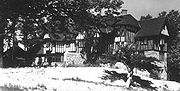
(now called Rathburn in Etobicoke) ran through the centre of the area and it was near this point the local developer Robert Home Smith built his home 'Edenbridge' (named after a village in southern England) overlooking the Humber Valley, at the turn of the century, after purchasing much of the surrounding land. To the west of Royal York another early resident, Frederick James, in 1908 developed his 'Red Gables' estate as a large landscaped park which, as the 'James Garden' landscaped park, remains today. While Robert Home Smith developed land in The Kingsway
neighbourhood to the south, the new 'Edenbridge' area was resuveyed and subdivided for development by Smith's company more slowly as the 'Humber Valley Surveys'; construction starting in the mid 1930s and continuing after Smith's death in 1935, until the 1960s. This 30 year span produced many different styles of home as fashions changed, leading to a very different style of development than originally invisioned by Robert Home Smith. The designs include: Georgian, Colonial, Tudor, English Cottage, Cape Cod, ranch bungalows, split-level, contemporary and modernist http://torontoneighbourhoods.net/regions/etobicoke/76_homes.html.
Later Development
The neighbourhood was planned as a wealthy suburb like 'the Kingsway' to the south, which it has largely remained despite the later development of many apartments immediately to the west along an extended 'the Kingsway', north of Dundas to the west of Edenbridge, during Etobicoke's rapid urbanisation in the 1960s. The extension of St. Clair Avenue
(Rathburn in Etobicoke) was redeveloped, in a similar style to the area in the west, as Anglesey; a winding street lined with apartments. Because Robert Home Smith had planned the, then slowly growing, area as a purely residential development, there are few institutions here. Rapid growth in Edenbridge and the higher density (north) Kingsway area to the west, necessitated the establishment of the Humber Valley Village public school, built in 1951, soon followed by the Humbertown Shopping Centre at Royal York and Dundas at the heart of 'Humber Valley Village'. The 1950s also saw the redevelopment of the Royal York and Dundas intersection as a highway style interchange, thought to be necessitated by urbanisation but now much criticised, which divided this neighbourhood from the older neighbourhoods to the south. Still mostly an exclusive and leafy neighbourhood, some recent high-density development is taking place along the short commercial stretch of Royal York in the south of the community across from the Humbertown Shopping Centre, such as the 'James Club' condominium, named after James Gardes.
. This connects to the Martin Goodman Trail, which follows Lake Ontario
.
Churches
operates buses along the main arteries of the neighbourhood. These include Royal York Rd, Islington Ave, Dundas St, Eglinton Ave, as well as Anglesey Blvd. These buses connect to Islington Station
and Royal York
Subway Stations.
Toronto
Toronto is the provincial capital of Ontario and the largest city in Canada. It is located in Southern Ontario on the northwestern shore of Lake Ontario. A relatively modern city, Toronto's history dates back to the late-18th century, when its land was first purchased by the British monarchy from...
, Ontario
Ontario
Ontario is a province of Canada, located in east-central Canada. It is Canada's most populous province and second largest in total area. It is home to the nation's most populous city, Toronto, and the nation's capital, Ottawa....
, Canada
Canada
Canada is a North American country consisting of ten provinces and three territories. Located in the northern part of the continent, it extends from the Atlantic Ocean in the east to the Pacific Ocean in the west, and northward into the Arctic Ocean...
. It is within the former City of Etobicoke and is a relatively affluent community. The boundaries are from Dundas Street on the south to Islington Avenue to the west, Eglinton Avenue
Eglinton Avenue
Eglinton Avenue, originally known as the Richview Sideroad within Etobicoke, is an east-west arterial thoroughfare in Toronto and Mississauga, in the Canadian province of Ontario. Within Toronto, Eglinton Avenue is the only road which crosses through all six former boroughs...
to the north, and the Humber River
Humber River (Ontario)
The Humber River is one of two major rivers on either side of Toronto, Ontario, Canada, the other being the Don River to the east. It was designated a Canadian Heritage River on September 24, 1999....
in the east. The neighbourhood is in the political riding
Electoral district (Canada)
An electoral district in Canada, also known as a constituency or a riding, is a geographical constituency upon which Canada's representative democracy is based...
of Etobicoke Centre.
Character
This neighbourhood can be further broken down into smaller communities. The triangular quadrant north of Dundas from Islington to Royal York, but south of Reigate is known as Chestnut Hills. The area surrounding Edenbridge, on the west side of Royal York is known as Lincoln Woods. Finally, the northern corner of Islington and Eglinton is sometimes referred to as The Greens of St. George's. Sometimes streets in the neighbourhood become their own little community as well, for example people tend to connect to names like Valecrest, North Dr, Chestnut Hills, all of which are streets in this neighbourhood.This neighbourhood is the wealthiest part of Etobicoke, and considered at par with the exclusive neighbourhoods that developed along Avenue Rd, and Yonge St, between Bloor and Highway 401. This wealth is evident in the schools. Catchment areas for schools such as Lambton-Kingsway, Humber Valley Village, Our Lady of Sorrows Elementary School, Etobicoke Collegiate Institute
Etobicoke Collegiate Institute
Etobicoke Collegiate Institute is a large high school located at the former centre of Etobicoke in the historic Islington neighbourhood in Toronto's west end, and is overseen by the Toronto District School Board...
, and Richview Collegiate Institute
Richview Collegiate Institute
Richview Collegiate Institute is a secondary school in Etobicoke, in the west end of Toronto, Ontario. It is in the Toronto District School Board....
are very defined. In some cases, those who do not live in the boundaries must apply with a lottery system to gain acceptance. There is also an independent elementary school, Kingsway College School, in the area, located on Dundas St.
History
Early DevelopmentAlthough laid-out in farm lots by 1805, most of the lots were purchased by some of Etobicoke's early great land owners who lived elsewhere in the township leaving this part of the Humber Valley little developed with no homes along what became Royal York Road from Dundas north to Eglinton. The Iroquois shorline, remnant of the ancient Lake Iroquois
Glacial Lake Iroquois
Glacial Lake Iroquois was a prehistoric proglacial lake that existed at the end of the last ice age approximately 13,000 years ago.The lake was essentially an enlargement of the present Lake Ontario that formed because the St. Lawrence River downstream from the lake was blocked by the ice sheet...
, which forms an escarpment along Dundas in Etobicoke, turns far to the north in this area, cut away by the Humber River creating the Humber Valley. The western extension of St. Clair Avenue
St. Clair Avenue
St. Clair Avenue is a major east-west street in Toronto, Ontario, Canada. It was laid out in the late 18th century by the British as a concession road , north of Bloor Street and north of Queen Street....
(now called Rathburn in Etobicoke) ran through the centre of the area and it was near this point the local developer Robert Home Smith built his home 'Edenbridge' (named after a village in southern England) overlooking the Humber Valley, at the turn of the century, after purchasing much of the surrounding land. To the west of Royal York another early resident, Frederick James, in 1908 developed his 'Red Gables' estate as a large landscaped park which, as the 'James Garden' landscaped park, remains today. While Robert Home Smith developed land in The Kingsway
The Kingsway
The Kingsway, known also as Kingsway South, is a residential neighbourhood of Toronto, Ontario, Canada. It is located in the former City of Etobicoke, an area that became the west end of Toronto upon amalgamation in 1998. It is bounded by Bloor Street to the south, Dundas Street to the north, the...
neighbourhood to the south, the new 'Edenbridge' area was resuveyed and subdivided for development by Smith's company more slowly as the 'Humber Valley Surveys'; construction starting in the mid 1930s and continuing after Smith's death in 1935, until the 1960s. This 30 year span produced many different styles of home as fashions changed, leading to a very different style of development than originally invisioned by Robert Home Smith. The designs include: Georgian, Colonial, Tudor, English Cottage, Cape Cod, ranch bungalows, split-level, contemporary and modernist http://torontoneighbourhoods.net/regions/etobicoke/76_homes.html.
Later Development
The neighbourhood was planned as a wealthy suburb like 'the Kingsway' to the south, which it has largely remained despite the later development of many apartments immediately to the west along an extended 'the Kingsway', north of Dundas to the west of Edenbridge, during Etobicoke's rapid urbanisation in the 1960s. The extension of St. Clair Avenue
St. Clair Avenue
St. Clair Avenue is a major east-west street in Toronto, Ontario, Canada. It was laid out in the late 18th century by the British as a concession road , north of Bloor Street and north of Queen Street....
(Rathburn in Etobicoke) was redeveloped, in a similar style to the area in the west, as Anglesey; a winding street lined with apartments. Because Robert Home Smith had planned the, then slowly growing, area as a purely residential development, there are few institutions here. Rapid growth in Edenbridge and the higher density (north) Kingsway area to the west, necessitated the establishment of the Humber Valley Village public school, built in 1951, soon followed by the Humbertown Shopping Centre at Royal York and Dundas at the heart of 'Humber Valley Village'. The 1950s also saw the redevelopment of the Royal York and Dundas intersection as a highway style interchange, thought to be necessitated by urbanisation but now much criticised, which divided this neighbourhood from the older neighbourhoods to the south. Still mostly an exclusive and leafy neighbourhood, some recent high-density development is taking place along the short commercial stretch of Royal York in the south of the community across from the Humbertown Shopping Centre, such as the 'James Club' condominium, named after James Gardes.
Parks
The defining element of this community would be the parks system. Not only are there five golf courses within one kilometre of every side of the borders, but huge networks of green space surround the Humber RiverHumber River (Ontario)
The Humber River is one of two major rivers on either side of Toronto, Ontario, Canada, the other being the Don River to the east. It was designated a Canadian Heritage River on September 24, 1999....
. This connects to the Martin Goodman Trail, which follows Lake Ontario
Lake Ontario
Lake Ontario is one of the five Great Lakes of North America. It is bounded on the north and southwest by the Canadian province of Ontario, and on the south by the American state of New York. Ontario, Canada's most populous province, was named for the lake. In the Wyandot language, ontarío means...
.
Schools
- Humber Valley Village Junior Middle School (HVV) is a public elementary schoolElementary schoolAn elementary school or primary school is an institution where children receive the first stage of compulsory education known as elementary or primary education. Elementary school is the preferred term in some countries, particularly those in North America, where the terms grade school and grammar...
on Hartfield Road, west of Royal York RoadRoyal York RoadRoyal York Road, historically known as Church Street or New Church Street, is a north-south arterial road in Toronto, Ontario, Canada. It is a concession road, 5 concessions west of Yonge Street, and runs through many residential neighbourhoods, most notably Mimico and the Kingsway...
, north of Dundas StreetDundas Street (Toronto)Dundas Street, also known as Highway 5 west of Toronto, is a major arterial road connecting the centre of that city with its western suburbs and southwestern Ontario beyond...
. The property lies within the valley of the Humber RiverHumber River (Ontario)The Humber River is one of two major rivers on either side of Toronto, Ontario, Canada, the other being the Don River to the east. It was designated a Canadian Heritage River on September 24, 1999....
. It was established in 1951.
- Kingsley Primary School
- Leonardo Da Vinci Academy
Institutions
- Humbertown Shopping Centre
- St. George's Golf and Country ClubSt. George's Golf and Country ClubSt. George's Golf and Country Club is a golf course and country club located in Etobicoke, Toronto, Ontario in the west end neighbourhood of Islington...
- James GardensJames GardensJames Gardens was purchased by Metro Toronto for $150,000 in 1955. It was the estate of Mr. and Mrs. Fred T. James. In 1908 Mr. James purchased the property from his wife's parents, Mr. and Mrs. Thomas Rumney, as well as the adjoining land from the Home Smith Company...
- Lambton Hills Cemetery
Churches
- Humber Valley United Church
- St Giles Kingsway Presbyterian Church
Transportation
The Toronto Transit CommissionToronto Transit Commission
-Island Ferry:The ferry service to the Toronto Islands was operated by the TTC from 1927 until 1962, when it was transferred to the Metro Parks and Culture department. Since 1998, the ferry service is run by Toronto Parks and Recreation.-Gray Coach:...
operates buses along the main arteries of the neighbourhood. These include Royal York Rd, Islington Ave, Dundas St, Eglinton Ave, as well as Anglesey Blvd. These buses connect to Islington Station
Islington (TTC)
Islington is a station on the Bloor–Danforth line of the subway system in Toronto, Canada. It is located at 3286 Bloor Street West at Islington Avenue. A central platform serves trains running in both directions....
and Royal York
Royal York (TTC)
Royal York is a station on the Bloor–Danforth line of the subway system in Toronto, Canada. It is located at 3012 Bloor Street West at Royal York Road.-History:The station was opened in 1968 in what was then the Borough of Etobicoke....
Subway Stations.
External links
- Edenbridge-Humber Valley neighbourhood profile
- http://schools.tdsb.on.ca/humbervv/
- http://www.eciweb.org/
- http://www.torontoneighbourhoods.net/regions/etobicoke/76.html