
Flint-Worcester Tornadoes
Encyclopedia
The Flint–Worcester Tornadoes were two tornado
es, one occurring in Flint, Michigan
on June 8, 1953, the other in Worcester, Massachusetts
on June 9, 1953. These tornadoes are among the deadliest in United States
history and were caused by the same storm system that moved eastward across the nation. The tornadoes are also related together in the public mind because, for a brief period following the Worcester tornado
, it was debated in the U.S. Congress whether recent atomic bomb testing in the upper atmosphere had caused the tornadoes. Congressman James E. Van Zandt
(R-Penn.) was among several members of Congress who expressed their belief that the June 4th bomb testing created the tornadoes, which occurred far outside the traditional tornado alley
. They demanded a response from the government. Meteorologists quickly dispelled such an assertion, and Congressman Van Zandt later retracted his statement.
The Flint-Worcester Tornadoes were the most infamous storms produced by a larger outbreak of severe weather that began in Nebraska, Iowa
and Wisconsin
, before moving across the Great Lakes
states, and then into New York
and New England
. Other F3 and F4
tornadoes struck other locations in Massachusetts
, Michigan
, New Hampshire
and Ohio
.
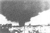
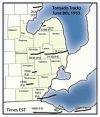 An F5 tornado hit Flint, Michigan on June 8, 1953. The tornado moved east-northeast 2 miles (3.2 km) north of Flushing
and devastated the north side of Flint and Beecher
. The tornado first descended about 8:30 p.m. on a humid evening near a drive-in movie theater that was flickering to life at twilight time. Motorists in the drive-in began to flee in panic, creating many auto accidents on nearby roads. The tornado dissipated near Lapeer, Michigan
. Nearly every home was destroyed on both sides of Coldwater Road. Multiple deaths were reported in 20 families, and it was reported that papers from Flint were deposited in Sarnia, Ontario
, Canada, some sixty miles east of Flint. One hundred and sixteen were killed, making it the tenth deadliest tornado in U.S. history. The death toll was surpassed by the 2011 Joplin tornado
. It is also one of only three F5
tornadoes ever to hit in Michigan
. Another F5
would hit in Hudsonville
on April 3, 1956.
 The storm system that created the Flint tornado moved eastward over southern Ontario
and Lake Erie
during the early morning hours of June 9. As radar was still primitive (or nonexistent) in 1953, inadequate severe weather predictions resulted: the Weather Bureau in Buffalo, New York
merely predicted thunderstorms and said that "a tornado may occur." As early as 10 A.M., however, the Weather Bureau in Boston
anticipated the likelihood of tornadic conditions that afternoon but feared the word "tornado" would strike panic in the public, and refrained from using it. Instead, as a compromise, they issued New England's first-ever severe thunderstorm watch
. Several hours later and virtually without warning (to the public at least), a strong F4 tornado struck central Massachusetts
in the late afternoon hours on June 9, 1953. The tornado descended over the Quabbin Reservoir
in Petersham, Massachusetts
at 4:25 P.M., and was witnessed by boaters on the reservoir - 3 funnels were seen at the beginning, with rapid dissipation of 1 of them. After brushing Petersham (occasionally with twin funnels several hundred feet apart), it tracked southeastwards and slammed into the rural towns of Barre
and Rutland
, followed by suburban Holden
, before killing 60 in heavily populated northern Worcester
. The towns of Shrewsbury
and Westborough
each suffered numerous fatalities. The tornado did its final destruction at the Fayville post office on Route 9 in Southborough
, and dissipated nearby over the Sudbury Reservoir in the Framingham
area, 84 minutes after it formed.
Ninety-four people were killed. A 95th fatality has recently been brought to light: a premature baby boy delivered in the hospital elevator to his traumatically injured mother - doctors tried keeping him alive but he succumbed a day and a half later.
Coincidentally, residents of central Massachusetts were coming home from work in the minutes before impact and picked up their evening newspapers to read the front-page headlines of the tornado that had just struck Flint, Michigan the previous evening. Some wondered if it was exactly the same tornado that was now bearing down on them.
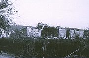
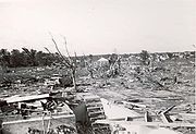
The massive Worcester tornado was on the ground for nearly an hour and a half. In that period it traveled 46 miles (74 km), reached 1 miles (1.6 km) in width and injured 1,300 people. Barre suffered the first 2 fatalities. The tornado then renewed its vigor in Rutland center with 2 more deaths, and widened to 1/2 mile in Holden, where 9 were killed outright (a 10th succumbed 2 days later), the worst-hit areas being Winthrop Oaks and Brentwood.
At 5:08 P.M., the tornado entered Worcester and grew to an unprecedented width of 1 miles (1.6 km). Damage was phenomenal in Worcester (second-largest city in Massachusetts) and in some areas equaled the worst damage in any U.S. tornado. Hardest-hit areas included Assumption College
(building is now home to Quinsigamond Community College
), where a priest and 2 nuns were killed. The main building's 3 foot (0.9144 m)-thick brick walls were reduced by 3 floors, and the landmark tower lost 3 stories. The nearby Burncoat Hill neighborhood saw heavy devastation (especially on its western slope), but it was the Uncatena-Great Brook Valley neighborhoods to the east of Burncoat Hill that were utterly leveled, houses simply vanishing and debris swept clean from the sites. Forty people died in the Uncatena-Great Brook Valley areas alone. A 12-ton bus was picked up, rolled over several times and was thrown against the newly-constructed Curtis Apartments in Great Brook Valley, resulting in the deaths of 2 passengers. The Curtis Apartments blueprints were blown all the way to Duxbury (near Plymouth), 75 miles (120.7 km) away. Across Boylston St. from the Curtis Apartments, the Brookside Home Farm (a city-operated dairy facility and laundry) sustained total damage, with 6 men killed and the loss of its herd of 80 Holsteins. Houses and bodies were blown into Lake Quinsigamond
. The 6 fatalities at Brookside were the most in any 1 particular building in the tornado.
The funnel maintained a 1 miles (1.6 km) width throughout much of Shrewsbury (12 killed), and was still doing maximum damage when it moved through downtown Westborough (5 deaths), where it began curving towards the northeast in its final leg. In the storm's final moments, 3 perished in the collapse of the Fayville Post Office in Southborough. Coincidentally, around the time it ended at 5:45 P.M., a tornado warning was issued, although by then it was too late. A separate F2/3 tornado also struck about the same time the warning was issued, in the nearby communities of Sutton
, Northbridge
, Mendon
, Bellingham
, Franklin
, Wrentham
and Mansfield
in Massachusetts, injuring 17 persons. Another tornado did minor damage and caused several injuries in Fremont
and Exeter
in Rockingham County
, New Hampshire
; other smaller tornadoes occurred in Colrain, Massachusetts
and Rollinsford, New Hampshire
.
Baseball-size hail was reported in a score of communities affected by the Worcester supercell. Airborne debris was strewn eastward, reaching the Blue Hill Meteorological Observatory
35 mi (56 km) away, and even out over Massachusetts Bay
and the Atlantic Ocean
. The farthest documented distance of tornado debris was an item that blew from Holden to Eastham
on Cape Cod
, a distance of 110 miles (177 km). This is one of the greatest such instances in a U.S. tornado.
The Worcester Tornado was a milestone in many regards. Besides its enormous size and unusual geographic location, at the time it was the nation's costliest tornado in raw dollars. Its 1,300 injuries were the 3rd worst in U.S. history (until the 1979 Wichita Falls tornado bumped it to number 4, where it still stands). The tally of 10,000 homeless stood unchallenged for 26 years until the '79 Wichita Falls storm.
However, the Worcester Tornado's greatest effect on the nation was its being the principal catalyst for the Storm Prediction Center
's reorganization on June 17, 1953, and subsequent implementation of a nationwide radar/storm spotter system. The results proved successful: since June 9, 1953, no single U.S. tornado had killed over 100 people until the Joplin, Missouri tornado of May 22, 2011.
The severity of this epic storm remained in dispute for a long period within the meteorological community. Official observations classified this tornado as F4, but damage was consistent with an F5 tornado in 5 of the affected towns (Rutland, Holden, Worcester, Shrewsbury and Westborough). As a result of this debate, the National Weather Service
took an unprecedented step and convened a panel of weather experts during the spring of 2005 to study the latest evidence on the wind strength of the Worcester Tornado. The panel considered whether to raise its designation to F5, but decided during the summer of 2005 to keep the official rating as a strong F4. The reasoning for this was that the anchoring techniques used in many of the destroyed or vanished homes could never now be ascertained with certainty, and some of these structures (many of recent postwar construction) were possibly more vulnerable to high winds than older homes. Without a proper engineering qualification, it would be nearly impossible to determine with 100% accuracy which damage was F5 and which was F4, as appearances would be similar.
 The year 1953 saw some of the deadliest tornadoes in U.S. history, including the Waco Tornado that hit on May 11, the Flint tornado of June 8, and the Worcester tornado on June 9. These 3 storms were also unique in occurring within a 30-day period.
Other severe tornadoes of 1953 hit Warner Robins, Georgia
in April, San Angelo, Texas
in May (same day as Waco
), Port Huron, Michigan
also in May, Cleveland in June (same day as Flint), and Vicksburg, Mississippi
in December.
Tornado
A tornado is a violent, dangerous, rotating column of air that is in contact with both the surface of the earth and a cumulonimbus cloud or, in rare cases, the base of a cumulus cloud. They are often referred to as a twister or a cyclone, although the word cyclone is used in meteorology in a wider...
es, one occurring in Flint, Michigan
Flint, Michigan
Flint is a city in the U.S. state of Michigan and is located along the Flint River, northwest of Detroit. The U.S. Census Bureau reports the 2010 population to be placed at 102,434, making Flint the seventh largest city in Michigan. It is the county seat of Genesee County which lies in the...
on June 8, 1953, the other in Worcester, Massachusetts
Worcester, Massachusetts
Worcester is a city and the county seat of Worcester County, Massachusetts, United States. Named after Worcester, England, as of the 2010 Census the city's population is 181,045, making it the second largest city in New England after Boston....
on June 9, 1953. These tornadoes are among the deadliest in United States
United States
The United States of America is a federal constitutional republic comprising fifty states and a federal district...
history and were caused by the same storm system that moved eastward across the nation. The tornadoes are also related together in the public mind because, for a brief period following the Worcester tornado
1953 Worcester Tornado
The 1953 Worcester Tornado was an extremely strong tornado that struck the city and surrounding area of Worcester, Massachusetts on June 9, 1953. It was part of the Flint–Worcester tornado outbreak sequence, which occurred over a three-day period from June 6—9, 1953. The storm stayed on the ground...
, it was debated in the U.S. Congress whether recent atomic bomb testing in the upper atmosphere had caused the tornadoes. Congressman James E. Van Zandt
James E. Van Zandt
James Edward Van Zandt was a Republican member of the U.S. House of Representatives from Pennsylvania.-Biography:...
(R-Penn.) was among several members of Congress who expressed their belief that the June 4th bomb testing created the tornadoes, which occurred far outside the traditional tornado alley
Tornado Alley
Tornado Alley is a colloquial and popular media term that most often refers to the area of the United States where tornadoes are most frequent. Although an official location is not defined, the area between the Rocky Mountains and Appalachian Mountains is usually associated with it.The areas...
. They demanded a response from the government. Meteorologists quickly dispelled such an assertion, and Congressman Van Zandt later retracted his statement.
The Flint-Worcester Tornadoes were the most infamous storms produced by a larger outbreak of severe weather that began in Nebraska, Iowa
Iowa
Iowa is a state located in the Midwestern United States, an area often referred to as the "American Heartland". It derives its name from the Ioway people, one of the many American Indian tribes that occupied the state at the time of European exploration. Iowa was a part of the French colony of New...
and Wisconsin
Wisconsin
Wisconsin is a U.S. state located in the north-central United States and is part of the Midwest. It is bordered by Minnesota to the west, Iowa to the southwest, Illinois to the south, Lake Michigan to the east, Michigan to the northeast, and Lake Superior to the north. Wisconsin's capital is...
, before moving across the Great Lakes
Great Lakes
The Great Lakes are a collection of freshwater lakes located in northeastern North America, on the Canada – United States border. Consisting of Lakes Superior, Michigan, Huron, Erie, and Ontario, they form the largest group of freshwater lakes on Earth by total surface, coming in second by volume...
states, and then into New York
New York
New York is a state in the Northeastern region of the United States. It is the nation's third most populous state. New York is bordered by New Jersey and Pennsylvania to the south, and by Connecticut, Massachusetts and Vermont to the east...
and New England
New England
New England is a region in the northeastern corner of the United States consisting of the six states of Maine, New Hampshire, Vermont, Massachusetts, Rhode Island, and Connecticut...
. Other F3 and F4
Fujita scale
The Fujita scale , or Fujita-Pearson scale, is a scale for rating tornado intensity, based primarily on the damage tornadoes inflict on human-built structures and vegetation...
tornadoes struck other locations in Massachusetts
Massachusetts
The Commonwealth of Massachusetts is a state in the New England region of the northeastern United States of America. It is bordered by Rhode Island and Connecticut to the south, New York to the west, and Vermont and New Hampshire to the north; at its east lies the Atlantic Ocean. As of the 2010...
, Michigan
Michigan
Michigan is a U.S. state located in the Great Lakes Region of the United States of America. The name Michigan is the French form of the Ojibwa word mishigamaa, meaning "large water" or "large lake"....
, New Hampshire
New Hampshire
New Hampshire is a state in the New England region of the northeastern United States of America. The state was named after the southern English county of Hampshire. It is bordered by Massachusetts to the south, Vermont to the west, Maine and the Atlantic Ocean to the east, and the Canadian...
and Ohio
Ohio
Ohio is a Midwestern state in the United States. The 34th largest state by area in the U.S.,it is the 7th‑most populous with over 11.5 million residents, containing several major American cities and seven metropolitan areas with populations of 500,000 or more.The state's capital is Columbus...
.
Confirmed tornadoes
This chart shows the number of tornadoes spawned from the initial storm system.June 7, 1953 event
| List of confirmed tornadoes — June 7, 1953 | ||||||
|---|---|---|---|---|---|---|
Fujita scale The Fujita scale , or Fujita-Pearson scale, is a scale for rating tornado intensity, based primarily on the damage tornadoes inflict on human-built structures and vegetation... |
|
|
|
|
|
|
| Kansas Kansas Kansas is a US state located in the Midwestern United States. It is named after the Kansas River which flows through it, which in turn was named after the Kansa Native American tribe, which inhabited the area. The tribe's name is often said to mean "people of the wind" or "people of the south... |
||||||
| F1 | E of Morland Morland, Kansas Morland is a city in Graham County, Kansas, in the United States. As of the 2010 census, the city population was 154.-Geography:Morland is located at... |
Graham Graham County, Kansas Graham County is a county located in northwest Kansas, in the Central United States. As of the 2010 census, the county population was 2,597. Its county seat and most populous city is Hill City... |
1900 | 0.1 miles (0.16 km) |
||
| F2 | S of Hill City Hill City, Kansas Hill City is a city in and the county seat of Graham County, Kansas, United States. As of the 2010 census, the city population was 1,474.-History:... |
Graham Graham County, Kansas Graham County is a county located in northwest Kansas, in the Central United States. As of the 2010 census, the county population was 2,597. Its county seat and most populous city is Hill City... |
1900 | 0.1 miles (0.16 km) |
||
| F0 | S of Edmond Edmond, Kansas Edmond is a city in Norton County, Kansas, United States. As of the 2010 census, the city population was 49.-Geography:Edmond is located at . According to the United States Census Bureau, the city has a total area of , all of it land.-Demographics:As of the census of 2000, there were 47 people,... |
Graham Graham County, Kansas Graham County is a county located in northwest Kansas, in the Central United States. As of the 2010 census, the county population was 2,597. Its county seat and most populous city is Hill City... |
1900 | 10.9 miles (17.4 km) |
||
| F0 | NE of Tampa Tampa, Kansas Tampa is a city in Marion County, Kansas, United States. As of the 2010 census, the city population was 112.-19th century:For millennia, the land that is currently Kansas was inhabited by Native Americans. In 1803, most of modern Kansas was secured by the United States as part of the Louisiana... to SW of Herington Herington, Kansas Herington is a city in Dickinson and Morris counties in the U.S. state of Kansas. Named after its founder, Monroe Davis Herington. As of the 2010 census, the city population was 2,526.-19th century:... |
Marion Marion County, Kansas Marion County is a county located in the U.S. state of Kansas. As of the 2010 census, the county population was 12,660. The county seat is Marion... , Dickinson Dickinson County, Kansas Dickinson County is a county located in Central Kansas, in the Central United States. As of the 2010 census, the county population was 19,754. Its county seat and most populous city is Abilene. It was named in honor of Daniel S. Dickinson.-19th century:In 1887, Mr. Herington successfully got... |
0445 | 12.6 miles (20.2 km) |
||
| Colorado Colorado Colorado is a U.S. state that encompasses much of the Rocky Mountains as well as the northeastern portion of the Colorado Plateau and the western edge of the Great Plains... |
||||||
| F1 | W of Julesburg Julesburg, Colorado The historic town of Julesburg is a statutory town that is the county seat of Sedgwick County, Colorado, United States. The town is located on the north side of the South Platte River. The population was 1,467 at the U.S. Census 2000... |
Sedgwick Sedgwick County, Colorado Sedgwick County is the northeasternmost of the 64 counties of the state of Colorado of the United States. The county was named for Fort Sedgwick, a military post along the Platte Trail, which was named for General John Sedgwick. The county population was 2,379 at U.S. 2010 Census... |
2000 | 0.1 miles (0.16 km) |
||
| F1 | N of Julesburg Julesburg, Colorado The historic town of Julesburg is a statutory town that is the county seat of Sedgwick County, Colorado, United States. The town is located on the north side of the South Platte River. The population was 1,467 at the U.S. Census 2000... |
Sedgwick Sedgwick County, Colorado Sedgwick County is the northeasternmost of the 64 counties of the state of Colorado of the United States. The county was named for Fort Sedgwick, a military post along the Platte Trail, which was named for General John Sedgwick. The county population was 2,379 at U.S. 2010 Census... |
2000 | 0.1 miles (0.16 km) |
||
| F0 | SW of Julesburg Julesburg, Colorado The historic town of Julesburg is a statutory town that is the county seat of Sedgwick County, Colorado, United States. The town is located on the north side of the South Platte River. The population was 1,467 at the U.S. Census 2000... (1st tornado) |
Sedgwick Sedgwick County, Colorado Sedgwick County is the northeasternmost of the 64 counties of the state of Colorado of the United States. The county was named for Fort Sedgwick, a military post along the Platte Trail, which was named for General John Sedgwick. The county population was 2,379 at U.S. 2010 Census... |
2200 | 0.1 miles (0.16 km) |
||
| F0 | SW of Julesburg Julesburg, Colorado The historic town of Julesburg is a statutory town that is the county seat of Sedgwick County, Colorado, United States. The town is located on the north side of the South Platte River. The population was 1,467 at the U.S. Census 2000... (2nd tornado) |
Sedgwick Sedgwick County, Colorado Sedgwick County is the northeasternmost of the 64 counties of the state of Colorado of the United States. The county was named for Fort Sedgwick, a military post along the Platte Trail, which was named for General John Sedgwick. The county population was 2,379 at U.S. 2010 Census... |
2200 | 0.1 miles (0.16 km) |
||
| F0 | NW of Julesburg Julesburg, Colorado The historic town of Julesburg is a statutory town that is the county seat of Sedgwick County, Colorado, United States. The town is located on the north side of the South Platte River. The population was 1,467 at the U.S. Census 2000... |
Sedgwick Sedgwick County, Colorado Sedgwick County is the northeasternmost of the 64 counties of the state of Colorado of the United States. The county was named for Fort Sedgwick, a military post along the Platte Trail, which was named for General John Sedgwick. The county population was 2,379 at U.S. 2010 Census... |
2200 | 0.1 miles (0.16 km) |
||
| Nebraska Nebraska Nebraska is a state on the Great Plains of the Midwestern United States. The state's capital is Lincoln and its largest city is Omaha, on the Missouri River.... |
||||||
| F2 | NE of Mason City Mason City, Nebraska Mason City is a village in Custer County, Nebraska, United States. The population was 178 at the 2000 census.-Geography:Mason City is located at .... |
Custer Custer County, Nebraska -History:Custer County was formed in 1877. It was named after General George Armstrong Custer, who was killed at the Battle of Little Bighorn.-Demographics:... , Sherman Sherman County, Nebraska -History:Sherman County was formed in 1871. It was named after General William Tecumseh Sherman.-Demographics:As of the census of 2000, there were 3,318 people, 1,394 households, and 935 families residing in the county. The population density was 6 people per square mile . There were 1,839... , Valley Valley County, Nebraska -Demographics:As of the census of 2000, there were 4,647 people, 1,965 households, and 1,298 families residing in the county. The population density was 8 people per square mile . There were 2,273 housing units at an average density of 4 per square mile... |
2030 | 6.6 miles (10.6 km) |
||
| F2 | NW of Giltner Giltner, Nebraska Giltner is a village in Hamilton County, Nebraska, United States. The population was 389 at the 2000 census.-Geography:Giltner is located at .... |
Hamilton Hamilton County, Nebraska -Demographics:As of the census of 2000, there were 9,403 people, 3,503 households, and 2,676 families residing in the county. The population density was 17 people per square mile . There were 3,850 housing units at an average density of 7 per square mile... |
2100 | 6.6 miles (10.6 km) |
||
| F0 | S of Phillips Phillips, Nebraska Phillips is a village in Hamilton County, Nebraska, United States. The population was 336 at the 2000 census.-Geography:Phillips is located at .... |
Hamilton Hamilton County, Nebraska -Demographics:As of the census of 2000, there were 9,403 people, 3,503 households, and 2,676 families residing in the county. The population density was 17 people per square mile . There were 3,850 housing units at an average density of 7 per square mile... |
2100 | 4.1 miles (6.6 km) |
||
| F1 | NE of Rising City Rising City, Nebraska Rising City is a village in Butler County, Nebraska, United States. The population was 386 at the 2000 census.-Geography:Rising City is located at .... to NW of Linwood Linwood, Kansas Linwood is a city in Leavenworth County, Kansas, United States, about east of Lawrence. As of the 2010 census, the city population was 375.-Beginnings:Linwood was founded as "Journeycake," being named after Charles Journeycake, the last Delaware chief... |
Butler Butler County, Nebraska -Demographics:As of the census of 2000, there were 8,767 people, 3,426 households, and 2,350 families residing in the county. The population density was 15 people per square mile . There were 3,901 housing units at an average density of 7 per square mile... |
2100 | 22.7 miles (36.3 km) |
||
| F4 | NW of Loup City Loup City, Nebraska Loup City is a city in Sherman County, Nebraska, United States. The population was 996 at the 2000 census. It is the county seat of Sherman County... to SW of Ord Ord, Nebraska Ord is a city in Valley County, Nebraska, United States. The population was 2,269 at the 2000 census. It is the county seat of Valley County. Ord was named in honor of Civil War general Edward O. C... |
Sherman Sherman County, Nebraska -History:Sherman County was formed in 1871. It was named after General William Tecumseh Sherman.-Demographics:As of the census of 2000, there were 3,318 people, 1,394 households, and 935 families residing in the county. The population density was 6 people per square mile . There were 1,839... , Valley Valley County, Nebraska -Demographics:As of the census of 2000, there were 4,647 people, 1,965 households, and 1,298 families residing in the county. The population density was 8 people per square mile . There were 2,273 housing units at an average density of 4 per square mile... |
2115 | 15 miles (24 km) |
11 deaths | |
| F2 | E of Scotia Scotia, Nebraska Scotia is a village in Greeley County, Nebraska, United States. The population was 308 at the 2000 census.-Geography:Scotia is located at .... to SW of Spalding Spalding, Nebraska Spalding is a village in Greeley County, Nebraska, United States. The population was 537 at the 2000 census.-Geography:Spalding is located at .... |
Greeley Greeley County, Nebraska -History:Greeley County was formed in 1871. It was named after Horace Greeley, a newspaper editor and politician of the mid-19th century.-Demographics:... |
2200 | 20.1 miles (32.2 km) |
||
| F2 | NE of Octavia Octavia, Nebraska Octavia is a village in Butler County, Nebraska, United States. The population was 145 at the 2000 census.-Geography:Octavia is located at .... |
Butler Butler County, Nebraska -Demographics:As of the census of 2000, there were 8,767 people, 3,426 households, and 2,350 families residing in the county. The population density was 15 people per square mile . There were 3,901 housing units at an average density of 7 per square mile... |
2200 | 6.9 miles (11 km) |
||
| F3 | NW of Albion Albion, Nebraska Albion is a city in and the county seat of Boone County, Nebraska, United States. The population was 1,797 at the 2000 census.-Geography:Albion is located at .... |
Boone Boone County, Nebraska -Demographics:As of the census of 2000, there were 6,259 people, 2,454 households, and 1,700 families residing in the county. The population density was 9 people per square mile . There were 2,733 housing units at an average density of 4 per square mile... |
2215 | 8 miles (12.8 km) |
||
| F0 | SE of Upland Upland, Nebraska Upland is a village in Franklin County, Nebraska, United States. The population was 179 at the 2000 census.-Geography:Upland is located at .... |
Franklin Franklin County, Nebraska -Demographics:As of the census of 2000, there were 3,574 people, 1,485 households, and 1,021 families residing in the county. The population density was 6 people per square mile . There were 1,746 housing units at an average density of 3 per square mile... |
2230 | 9 miles (14.4 km) |
||
| F1 | E of Macon | Franklin Franklin County, Nebraska -Demographics:As of the census of 2000, there were 3,574 people, 1,485 households, and 1,021 families residing in the county. The population density was 6 people per square mile . There were 1,746 housing units at an average density of 3 per square mile... |
2300 | 15 miles (24 km) |
||
| F2 | SW of Battle Creek Battle Creek, Nebraska Battle Creek is a city in Madison County, Nebraska, United States. It is part of the Norfolk, Nebraska Micropolitan Statistical Area. The population was 1,158 at the 2000 census.-History:... to S of Pierce Pierce, Nebraska Pierce is a city in Pierce County, Nebraska, United States. It is part of the Norfolk, Nebraska Micropolitan Statistical Area. The population was 1,767 at the 2010 census... |
Madison Madison County, Nebraska -Demographics:As of the census of 2000, there were 35,226 people, 13,436 households, and 8,894 families residing in the county. The population density was 62 people per square mile . There were 14,432 housing units at an average density of 25 per square mile... |
2300 | 16.6 miles (26.6 km) |
||
| F2 | SW of Pierce Pierce, Nebraska Pierce is a city in Pierce County, Nebraska, United States. It is part of the Norfolk, Nebraska Micropolitan Statistical Area. The population was 1,767 at the 2010 census... to SW of Laurel Laurel, Nebraska Laurel is a city in Cedar County, Nebraska, United States. The population was 964 at the 2010 census.-Geography:Laurel is located at .According to the United States Census Bureau, the city has a total area of , all land.... |
Pierce Pierce County, Nebraska -History:Pierce County was formed in 1856. It was named after President Franklin Pierce.-Demographics:As of the census of 2000, there were 7,857 people, 2,979 households, and 2,141 families residing in the county. The population density was 14 people per square mile . There were 3,247 housing... , Cedar Cedar County, Nebraska -History:Cedar County was formed in 1855. It was named for the great number of cedars that grow there.-Demographics:As of the census of 2000, there were 9,615 people, 3,623 households, and 2,565 families residing in the county. The population density was 13 people per square mile . There were... |
2300 | 31 miles (49.6 km) |
||
| F1 | N of Breslau Foster, Nebraska Foster is a village in Pierce County, Nebraska, United States. It is part of the Norfolk, Nebraska Micropolitan Statistical Area. The population was 63 at the 2000 census.-Geography:Foster is located at .... |
Pierce Pierce County, Nebraska -History:Pierce County was formed in 1856. It was named after President Franklin Pierce.-Demographics:As of the census of 2000, there were 7,857 people, 2,979 households, and 2,141 families residing in the county. The population density was 14 people per square mile . There were 3,247 housing... |
2310 | 8.2 miles (13.1 km) |
||
| F0 | SW of Martinsburg Martinsburg, Nebraska Martinsburg is a village in Dixon County, Nebraska, United States. It is part of the Sioux City, IA–NE–SD Metropolitan Statistical Area... |
Dixon Dixon County, Nebraska -Demographics:As of the census of 2000, there were 6,339 people, 2,413 households, and 1,705 families residing in the county. The population density was 13 people per square mile . There were 2,673 housing units at an average density of 6 per square mile... |
2340 | 1.5 miles (2.4 km) |
||
| F2 | NW of Blair Blair, Nebraska Blair is a city in and the county seat of Washington County, Nebraska, United States. The population was 7,990 at the 2000 census. Blair is a part of the Omaha-Council Bluffs Metropolitan Statistical Area.- History :... |
Washington Washington County, Nebraska -National protected areas:*Boyer Chute National Wildlife Refuge*DeSoto National Wildlife Refuge -Demographics:As of the census of 2000, there were 18,780 people, 6,940 households, and 5,149 families residing in the county. The population density was 48 people per square mile . There were 7,408... |
0045 | 4.1 miles (6.6 km) |
||
| F0 | S of Hooper Hooper, Nebraska Hooper is a city in Dodge County, Nebraska, United States. The population was 827 at the 2000 census.-Geography:Hooper is located at .According to the United States Census Bureau, the city has a total area of , all of it land.... |
Dodge Dodge County, Nebraska - History :Dodge County was formed in 1855. It was named after the US Senator Augustus Caesar Dodge.- Demographics :As of the census of 2000, there were 36,160 people, 14,433 households, and 9,756 families residing in the county. The population density was 68 people per square mile . There were... |
0100 | 1 mile (1.6 km) |
||
| South Dakota South Dakota South Dakota is a state located in the Midwestern region of the United States. It is named after the Lakota and Dakota Sioux American Indian tribes. Once a part of Dakota Territory, South Dakota became a state on November 2, 1889. The state has an area of and an estimated population of just over... |
||||||
| F0 | N of Mitchell Mitchell, South Dakota -Demographics:As of the census of 2000, there were 14,558 people, 6,121 households, and 3,599 families residing in the city. The population density was 1,475.7 people per square mile . There were 6,555 housing units at an average density of 664.4 per square mile... |
Davison Davison County, South Dakota As of the census of 2000, there were 18,741 people, 7,585 households, and 4,770 families residing in the county. The population density was 43 people per square mile . There were 8,093 housing units at an average density of 19 per square mile... |
2345 | 1.5 miles (2.4 km) |
||
| Iowa Iowa Iowa is a state located in the Midwestern United States, an area often referred to as the "American Heartland". It derives its name from the Ioway people, one of the many American Indian tribes that occupied the state at the time of European exploration. Iowa was a part of the French colony of New... |
||||||
| F2 | NE of Westfield Westfield, Iowa Westfield is a city in Plymouth County, Iowa, United States. The population was 189 at the 2000 census. It is the westernmost point in Iowa, this being due to a bend in the Big Sioux River. A sign on the highway says "In Iowa, West Is The Best"... |
Plymouth Plymouth County, Iowa Plymouth County is a county located in the U.S. state of Iowa. The population was 24,986 in the 2010 census, an increase from 24,849 in the 2000 census. The county seat is Le Mars... |
0015 | 11.3 miles (18.1 km) |
||
| F2 | N of Ida Grove Ida Grove, Iowa Ida Grove is a city in Ida County, Iowa, United States. The population was 2,350 at the 2000 census. It is the county seat of Ida County.-Geography:Ida Grove is located at... to E of Fenton Fenton, Iowa Fenton is a city in Kossuth County, Iowa, United States. The population was 317 at the 2000 census.-History:The town was named after former New York State governor and senator Reuben E. Fenton, although today nobody knows why.-Geography:... |
Ida Ida County, Iowa -2010 census:The 2010 census recorded a population of 7,089 in the county, with a population density of . There were 3,426 housing units, of which 3,052 were occupied.-2000 census:... , Sac Sac County, Iowa -2010 census:The 2010 census recorded a population of 10,350 in the county, with a population density of . There were 5,429 housing units, of which 4,482 were occupied.-2000 census:... , Pocahontas Pocahontas County, Iowa -2010 census:The 2010 census recorded a population of 7,310 in the county, with a population density of . There were 3,794 housing units, of which 3,233 were occupied.-2000 census:... , Kossuth Kossuth County, Iowa -2010 census:The 2010 census recorded a population of 15,543 in the county, with a population density of . There were 7,486 housing units, of which 6,697 were occupied.-2000 census:... |
0130 | 49.2 miles (78.7 km) |
||
| F2 | N of Gowne to SW of Olaf | Webster Webster County, Iowa -2010 census:The 2010 census recorded a population of 38,013 in the county, with a population density of . There were 17,035 housing units, of which 15,580 were occupied.-2000 census:... , Hamilton Hamilton County, Iowa -2010 census:The 2010 census recorded a population of 15,673 in the county, with a population density of . There were 7,219 housing units, of which 6,540 were occupied.-2000 census:... , Wright Wright County, Iowa -2010 census:The 2010 census recorded a population of 13,229 in the county, with a population density of . There were 6,529 housing units, of which 5,625 were occupied.-2000 census:... |
0300 | 49 miles (78.4 km) |
||
| F3 | W of Pomeroy Pomeroy, Iowa Pomeroy is a city in Calhoun County, Iowa, United States. The population was 662 at the 2010 census.- History :On July 6, 1893, Pomeroy was struck by a tornado that was later estimated to be F5 on the Fujita scale. With a damage path wide and long, the tornado destroyed about 80% of the homes in... to SE of Bode Bode, Iowa Bode is a city in Humboldt County, Iowa, United States. The population was 327 at the 2000 census.-Geography:Bode is located at .According to the United States Census Bureau, the city has a total area of , all of it land.... |
Calhoun Calhoun County, Iowa -2010 census:The 2010 census recorded a population of 14,867 in the county, with a population density of . There were 5,108 housing units, of which 4,242 were occupied.-2000 census:... , Pocahontas Pocahontas County, Iowa -2010 census:The 2010 census recorded a population of 7,310 in the county, with a population density of . There were 3,794 housing units, of which 3,233 were occupied.-2000 census:... , Humboldt Humboldt County, Iowa -2010 census:The 2010 census recorded a population of 9,815 in the county, with a population density of . There were 4,684 housing units, of which 4,209 were occupied.-2000 census:... |
0315 | 30.7 miles (49.1 km) |
||
| F2 | NE of Winterset Winterset, Iowa Winterset is a city in Madison County, Iowa, United States. The population was 4,768 at the 2000 census. It is the county seat of Madison County.... to E of Walford Walford, Iowa Walford is a city in Benton and Linn counties in the U.S. state of Iowa. The population was 1,463 at the 2010 census. It is part of the Cedar Rapids Metropolitan Statistical Area.-Geography:Walford is located at .... |
Madison Madison County, Iowa -2010 census:The 2010 census recorded a population of 15,679 in the county, with a population density of . There were 6,554 housing units, of which 6,025 were occupied.-2000 census:... , Warren, Polk Polk County, Iowa Polk County is a county located in the U.S. state of Iowa. The population was 430,640 in the 2010 census, an increase from 374,601 in the 2000 census. The county seat is Des Moines, which is also the capital city of Iowa... , Jasper Jasper County, Iowa -2010 census:The 2010 census recorded a population of 36,842 in the county, with a population density of . There were 16,181 housing units, of which 14,806 were occupied.-2000 census:... , Poweshiek Poweshiek County, Iowa -2010 census:The 2010 census recorded a population of 18,914 in the county, with a population density of . There were 8,949 housing units, of which 7,555 were occupied.-2000 census:... , Iowa Iowa County, Iowa -2010 census:The 2010 census recorded a population of 16,355 in the county, with a population density of . There were 7,258 housing units, of which 6,677 were occupied.-2000 census:... , Johnson Johnson County, Iowa -2010 census:The 2010 census recorded a population of 130,882 in the county, with a population density of . There were 55,967 housing units, of which 52,715 were occupied.-2000 census:... |
0315 | 116 miles (185.6 km) |
||
| F1 | E of Boxholm Boxholm, Iowa Boxholm is a city in Grant Township, Boone County, Iowa, United States. The population was 215 at the 2000 census. It is part of the 'Boone, Iowa Micropolitan Statistical Area', which is a part of the larger 'Ames-Boone, Iowa Combined Statistical Area'.... |
Boone Boone County, Iowa -2010 census:The 2010 census recorded a population of 26,306 in the county, with a population density of . There were 11,756 housing units, of which 10,728 were occupied.-2000 census:... , Hamilton Hamilton County, Iowa -2010 census:The 2010 census recorded a population of 15,673 in the county, with a population density of . There were 7,219 housing units, of which 6,540 were occupied.-2000 census:... |
0330 | 2.3 miles (3.7 km) |
||
| Minnesota Minnesota Minnesota is a U.S. state located in the Midwestern United States. The twelfth largest state of the U.S., it is the twenty-first most populous, with 5.3 million residents. Minnesota was carved out of the eastern half of the Minnesota Territory and admitted to the Union as the thirty-second state... |
||||||
| F1 | SE of Trimont Trimont, Minnesota Trimont is a city in Martin County, Minnesota, USA. The population was 747 at the 2010 census. The small community is located in south central Minnesota between Sherburn and St. James on Minnesota State Highway 4. Interstate 90 is nearby.... to SE of Grogan |
Martin Martin County, Minnesota As of the census of 2000, there were 21,802 people, 9,067 households, and 6,047 families residing in the county. The population density was 31 people per square mile . There were 9,800 housing units at an average density of 14 per square mile... , Watonwan Watonwan County, Minnesota As of the census of 2000, there were 11,876 people, 4,627 households, and 3,141 families residing in the county. The population density was 27 people per square mile . There were 5,036 housing units at an average density of 12 per square mile... |
0100 | 19.1 miles (30.6 km) |
||
| Source: Tornado History Project - June 7, 1953 Storm Data | ||||||
June 8, 1953 event
| List of confirmed tornadoes — June 8, 1953 | ||||||
|---|---|---|---|---|---|---|
Fujita scale The Fujita scale , or Fujita-Pearson scale, is a scale for rating tornado intensity, based primarily on the damage tornadoes inflict on human-built structures and vegetation... |
|
|
|
|
|
|
| Michigan Michigan Michigan is a U.S. state located in the Great Lakes Region of the United States of America. The name Michigan is the French form of the Ojibwa word mishigamaa, meaning "large water" or "large lake".... |
||||||
| F4 | NE of Temperance Temperance, Michigan Temperance is an unincorporated community in Bedford Township, Monroe County in the U.S. state of Michigan. It is a census-designated place for statistical purposes. The population was 7,757 at the 2000 census... |
Monroe Monroe County, Michigan Monroe County is a county in the U.S. state of Michigan. According to the U.S. Census Bureau, the 2010 population is 152,021. The largest city and county seat is Monroe. The U.S. Census Bureau defines all of Monroe County as conterminous with the Monroe Metropolitan Area... |
2315 | 5.4 miles (8.6 km) |
4 deaths | |
| F3 | SW of Ann Arbor Ann Arbor, Michigan Ann Arbor is a city in the U.S. state of Michigan and the county seat of Washtenaw County. The 2010 census places the population at 113,934, making it the sixth largest city in Michigan. The Ann Arbor Metropolitan Statistical Area had a population of 344,791 as of 2010... |
Washtenaw Washtenaw County, Michigan Washtenaw County is a county in the U.S. state of Michigan. As of the 2010 census, the population was 344,791. Its county seat is Ann Arbor. The United States Office of Management and Budget defines the county as part of the Detroit–Warren–Flint Combined Statistical Area... |
0030 | 11.3 miles (18.1 km) |
1 death | |
| F3 | W of Milford Milford, Michigan Milford is a village in Oakland County in the U.S. state of Michigan. The population was 6,175 at the 2010 census. The village is located within Milford Township.- Geography :... |
Livingston Livingston County, Michigan -Demographics:As of the census of 2000, there were 156,951 people, 55,384 households, and 43,531 families residing in the county. The population density was 276 people per square mile . There were 58,919 housing units at an average density of 104 per square mile... , Oakland Oakland County, Michigan -Demographics:As of the 2010 Census, there were 1,202,362 people, 471,115 households, and 315,175 families residing in the county. The population density as of the 2000 census was 1,369 people per square mile . There were 492,006 housing units at an average density of 564 per square mile... |
0030 | 9.1 miles (14.6 km) |
||
| F2 | E of Sand Lake Sand Lake, Michigan Sand Lake is a village in Kent County in the U.S. state of Michigan. The population was 492 at the 2000 census.-Geography:According to the United States Census Bureau, the village has a total area of , of which, of it is land and of it is water.... to N of Oscoda Oscoda, Michigan Oscoda is an unincorporated community in the U.S. state of Michigan located on the northern side of the Au Sable River where it enters Lake Huron. The community of Au Sable is on the other side of the river. Oscoda is in Oscoda Township in Iosco County, and not in Oscoda County, which is to the... |
Iosco Iosco County, Michigan -Demographics:As of the census of 2000, there were 27,339 people, 11,727 households, and 7,857 families residing in the county. The population density was 50 people per square mile . There were 20,432 housing units at an average density of 37 per square mile... |
0040 | 16.6 miles (26.6 km) |
4 deaths | |
| F3 | S of Spruce | Alcona Alcona County, Michigan Alcona County is a county of the U.S. state of Michigan. As of the 2000 census, the population is 11,719. Its county seat is Harrisville. Alphabetically it is the first county in Michigan, as its flag states "First of the 83".-History:... |
0108 | 1.8 miles (2.9 km) |
||
| F5 | N of Flushing Flushing, Michigan Flushing is a city in Genesee County in the U.S. state of Michigan. The population was 8,348 at the 2000 census. Flushing is considered a suburb of Flint. It is situated within the area of Flushing Charter Township, but is administratively autonomous... to N of Columbiaville Columbiaville, Michigan Columbiaville is a village in Lapeer County in the U.S. state of Michigan. The population was 815 at the 2000 census. The village is within Marathon Township on the Flint River.-History:... |
Genesee Genesee County, Michigan -Interstates:* I-69* I-75* I-475-Michigan State Trunklines:* M-13* M-15* M-21* M-54* M-57-Demographics:As of the census of 2000, there were 436,141 people, 169,825 households, and 115,990 families residing in the county. The population density was 682 people per square mile . There were 183,630... , Lapeer Lapeer County, Michigan -Demographics:As of the census of 2000, there were 87,904 people, 30,729 households, and 23,876 families residing in the county. The population density was 134 people per square mile . There were 32,732 housing units at an average density of 50 per square mile... |
0130 | 18.9 miles (30.2 km) |
116 deaths | |
| F0 | SW of Caseville Caseville, Michigan Caseville is a city in Huron County in the U.S. state of Michigan. The population was 888 at the 2000 census. The city is surrounded by Caseville Township. It is home to the 10-day festival, a tribute to Jimmy Buffett's song "Cheeseburger in Paradise"... |
Huron Huron County, Michigan -Highways:* M-19* M-25* M-53* M-142-Demographics:As of the census of 2000, there were 36,079 people, 14,597 households, and 10,144 families residing in the county. The population density was 43 people per square mile . There were 20,430 housing units at an average density of 24 per square mile... |
0300 | 0.1 miles (0.16 km) |
||
| F4 | N of Kings Mill to N of Port Huron Port Huron, Michigan Port Huron is a city in the U.S. state of Michigan and the county seat of St. Clair County. The population was 30,184 at the 2010 census. The city is adjacent to Port Huron Township but is administratively autonomous. It is joined by the Blue Water Bridge over the St. Clair River to Sarnia,... |
Lapeer Lapeer County, Michigan -Demographics:As of the census of 2000, there were 87,904 people, 30,729 households, and 23,876 families residing in the county. The population density was 134 people per square mile . There were 32,732 housing units at an average density of 50 per square mile... , St. Clair St. Clair County, Michigan -Interstates:* I-69 enters the county from the west, coming from Lansing and Flint, terminating at the approach to the Blue Water Bridge in Port Huron.... |
0330 | 33.8 miles (54.1 km) |
||
| Ohio Ohio Ohio is a Midwestern state in the United States. The 34th largest state by area in the U.S.,it is the 7th‑most populous with over 11.5 million residents, containing several major American cities and seven metropolitan areas with populations of 500,000 or more.The state's capital is Columbus... |
||||||
| F4 | N of Deshler Deshler, Ohio Deshler is a village in Henry County, Ohio, United States. The population was 1,831 at the 2000 census.-Geography:Deshler is located at .... to Cleveland Cleveland, Ohio Cleveland is a city in the U.S. state of Ohio and is the county seat of Cuyahoga County, the most populous county in the state. The city is located in northeastern Ohio on the southern shore of Lake Erie, approximately west of the Pennsylvania border... |
Henry Henry County, Ohio Henry County is a county located in the state of Ohio, United States. As of the 2010 census, the population was 28,215. Its county seat is Napoleon and is named for Patrick Henry, the Virginian famous for his "give me liberty or give me death" speech.... , Wood Wood County, Ohio Wood County is a county located in the state of Ohio, United States. As of the 2010 census, the population was 125,488. Its county seat is Bowling Green. The county was named for Captain Eleazer D. Wood, the engineer for General William Henry Harrison's army, who built Fort Meigs in the War of 1812... , Sandusky Sandusky County, Ohio Sandusky County is a county in the U.S. state of Ohio. As of the 2010 census, the population was 60,944. Its county seat is Fremont and it is named for a native word meaning "water" .... , Erie Erie County, Ohio As of the census of 2000, there were 79,551 people, 31,727 households, and 21,764 families residing in the county. The population density was 312 people per square mile . There were 35,909 housing units at an average density of 141 per square mile... , Lorain Lorain County, Ohio Lorain County is a county located in the U.S. state of Ohio, and is considered to be a part of what is locally referred to as Greater Cleveland. As of the 2010 census, its population was 301,356. an increase from 284,664 in 2000... , Cuyahoga Cuyahoga County, Ohio Cuyahoga County is a county located in the state of Ohio, United States. It is the most populous county in Ohio; as of the 2010 census, the population was 1,280,122. Its county seat is Cleveland. Cuyahoga County is part of Greater Cleveland, a metropolitan area, and Northeast Ohio, a... |
0000 | 118 miles (188.8 km) |
17 deaths | |
| Source: Tornado History Project - June 8, 1953 Storm Data | ||||||
June 9, 1953 event
| List of confirmed tornadoes — June 9, 1953 | ||||||
|---|---|---|---|---|---|---|
Fujita scale The Fujita scale , or Fujita-Pearson scale, is a scale for rating tornado intensity, based primarily on the damage tornadoes inflict on human-built structures and vegetation... |
|
|
|
|
|
|
| Massachusetts Massachusetts The Commonwealth of Massachusetts is a state in the New England region of the northeastern United States of America. It is bordered by Rhode Island and Connecticut to the south, New York to the west, and Vermont and New Hampshire to the north; at its east lies the Atlantic Ocean. As of the 2010... |
||||||
| F4 | W of Petersham Petersham, Massachusetts Petersham is a town in Worcester County, Massachusetts, United States. The population was 1,234 at the 2010 census. Petersham is home to a considerable amount of conservation land, including the Quabbin Reservation, Harvard Forest, the Swift River Reservation, and Federated Women's Club State... to NE of Fayville |
Worcester Worcester County, Massachusetts -Demographics:In 1990 Worcester County had a population of 709,705.As of the census of 2000, there were 750,963 people, 283,927 households, and 192,502 families residing in the county. The population density was 496 people per square mile . There were 298,159 housing units at an average density... |
2025 | 46.0 miles (74.03 km) |
94 deaths | |
| F3 | E of West Millbury to SE of Foxborough Foxborough, Massachusetts -Demographics:As of the census of 2000, there were 16,246 people, 6,141 households, and 4,396 families residing in the town. The population density was 809.1 people per square mile . There were 6,299 housing units at an average density of 313.7 per square mile... |
Worcester Worcester County, Massachusetts -Demographics:In 1990 Worcester County had a population of 709,705.As of the census of 2000, there were 750,963 people, 283,927 households, and 192,502 families residing in the county. The population density was 496 people per square mile . There were 298,159 housing units at an average density... , Norfolk Norfolk County, Massachusetts -National protected areas:* Adams National Historical Park* Boston Harbor Islands National Recreation Area * Frederick Law Olmsted National Historic Site* John Fitzgerald Kennedy National Historic Site-Demographics:... , Bristol Bristol County, Massachusetts -Demographics:As of the census of 2000, there were 534,678 people, 205,411 households, and 140,706 families residing in the county. The population density was 962 people per square mile . There were 216,918 housing units at an average density of 390 per square mile... |
2130 | 28 miles (44.8 km) |
||
| New Hampshire New Hampshire New Hampshire is a state in the New England region of the northeastern United States of America. The state was named after the southern English county of Hampshire. It is bordered by Massachusetts to the south, Vermont to the west, Maine and the Atlantic Ocean to the east, and the Canadian... |
||||||
| F3 | SW of Exeter Exeter, New Hampshire Exeter is a town in Rockingham County, New Hampshire, United States. The town's population was 14,306 at the 2010 census. Exeter was the county seat until 1997, when county offices were moved to neighboring Brentwood... |
Rockingham Rockingham County, New Hampshire -Demographics:As of the census of 2000, there were 277,359 people, 104,529 households, and 74,320 families residing in the county. The population density was 399 people per square mile . There were 113,023 housing units at an average density of 163 per square mile... |
2120 | 1.5 miles (2.4 km) |
||
| F1 | W of South Berwick South Berwick, Maine South Berwick is a town in York County, Maine, United States. The population was 7,220 at the 2010 census. South Berwick is home to Berwick Academy, a private, co-educational university-preparatory day school founded in 1791... |
Strafford Strafford County, New Hampshire -Demographics:As of the census of 2000, there were 112,233 people, 42,581 households, and 27,762 families residing in the county. The population density was 304 people per square mile . There were 45,539 housing units at an average density of 124 per square mile... |
2200 | 1 mile (1.6 km) |
||
| Source: Tornado History Project - June 9, 1953 Storm Data | ||||||
Flint tornado
Flushing, Michigan
Flushing is a city in Genesee County in the U.S. state of Michigan. The population was 8,348 at the 2000 census. Flushing is considered a suburb of Flint. It is situated within the area of Flushing Charter Township, but is administratively autonomous...
and devastated the north side of Flint and Beecher
Beecher, Michigan
Beecher is an unincorporated community in Genesee County in the U.S. state of Michigan. It is a census-designated place for statistical purposes and has no legal status as a municipality. The population was 12,793 at the 2000 census....
. The tornado first descended about 8:30 p.m. on a humid evening near a drive-in movie theater that was flickering to life at twilight time. Motorists in the drive-in began to flee in panic, creating many auto accidents on nearby roads. The tornado dissipated near Lapeer, Michigan
Lapeer, Michigan
Lapeer is a city in the U.S. state of Michigan and is the county seat of Lapeer County. As of the 2010 census, the city population was 8,841. Most of the city was incorporated from land that was formerly in Lapeer Township, though portions were also annexed from Mayfield Township and Elba...
. Nearly every home was destroyed on both sides of Coldwater Road. Multiple deaths were reported in 20 families, and it was reported that papers from Flint were deposited in Sarnia, Ontario
Sarnia, Ontario
Sarnia is a city in Southern Ontario, Canada . It is the largest city on Lake Huron and is located where the upper Great Lakes empty into the St. Clair River....
, Canada, some sixty miles east of Flint. One hundred and sixteen were killed, making it the tenth deadliest tornado in U.S. history. The death toll was surpassed by the 2011 Joplin tornado
2011 Joplin tornado
The 2011 Joplin tornado was a devastating EF5 multiple-vortex tornado that struck Joplin, Missouri, USA late in the afternoon of Sunday, May 22, 2011. It was part of a larger late-May tornado outbreak sequence and reached a maximum width of in excess of during its path through the southern part of...
. It is also one of only three F5
Fujita scale
The Fujita scale , or Fujita-Pearson scale, is a scale for rating tornado intensity, based primarily on the damage tornadoes inflict on human-built structures and vegetation...
tornadoes ever to hit in Michigan
Michigan
Michigan is a U.S. state located in the Great Lakes Region of the United States of America. The name Michigan is the French form of the Ojibwa word mishigamaa, meaning "large water" or "large lake"....
. Another F5
Hudsonville-Standale Tornado of April 1956
The Hudsonville-Standale tornado was an F5 tornado that devastated the Hudsonville and Standale, Michigan areas on April 3, 1956. It was one of three tornadoes to move across southwest Lower Michigan on that day. A fourth tornado struck north of the Manistee area...
would hit in Hudsonville
Hudsonville, Michigan
Hudsonville is a city in Ottawa County in the U.S. state of Michigan. As of the 2000 census, the city population was 7,160.-Demographics:As of the census of 2000, there were 7,160 people, 2,514 households, and 1,920 families residing in the city. The population density was 1,729.1 per square mile...
on April 3, 1956.
Worcester tornado
Southern Ontario
Southern Ontario is a region of the province of Ontario, Canada that lies south of the French River and Algonquin Park. Depending on the inclusion of the Parry Sound and Muskoka districts, its surface area would cover between 14 to 15% of the province. It is the southernmost region of...
and Lake Erie
Lake Erie
Lake Erie is the fourth largest lake of the five Great Lakes in North America, and the tenth largest globally. It is the southernmost, shallowest, and smallest by volume of the Great Lakes and therefore also has the shortest average water residence time. It is bounded on the north by the...
during the early morning hours of June 9. As radar was still primitive (or nonexistent) in 1953, inadequate severe weather predictions resulted: the Weather Bureau in Buffalo, New York
Buffalo, New York
Buffalo is the second most populous city in the state of New York, after New York City. Located in Western New York on the eastern shores of Lake Erie and at the head of the Niagara River across from Fort Erie, Ontario, Buffalo is the seat of Erie County and the principal city of the...
merely predicted thunderstorms and said that "a tornado may occur." As early as 10 A.M., however, the Weather Bureau in Boston
Boston
Boston is the capital of and largest city in Massachusetts, and is one of the oldest cities in the United States. The largest city in New England, Boston is regarded as the unofficial "Capital of New England" for its economic and cultural impact on the entire New England region. The city proper had...
anticipated the likelihood of tornadic conditions that afternoon but feared the word "tornado" would strike panic in the public, and refrained from using it. Instead, as a compromise, they issued New England's first-ever severe thunderstorm watch
Severe thunderstorm watch
[File:Annual_severe_thunderstorm_watch_frequency_in_the_United_States.svg|thumb|right|300px|Map of average annual severe thunderstorm watches in the United States between 1999 and 2008.Legend:...
. Several hours later and virtually without warning (to the public at least), a strong F4 tornado struck central Massachusetts
Central Massachusetts
Central Massachusetts is the geographically central region of Massachusetts. Though definitions vary, most include all of Worcester County and the northwest corner of Middlesex County. Worcester, the largest city in the area and the seat of Worcester County, is often considered the cultural capital...
in the late afternoon hours on June 9, 1953. The tornado descended over the Quabbin Reservoir
Quabbin Reservoir
The Quabbin Reservoir is the largest inland body of water in the Commonwealth of Massachusetts and was built between 1930 and 1939. Today along with the Wachusett Reservoir, it is the primary water supply for Boston, some to the east, as well as 40 other communities in Greater Boston...
in Petersham, Massachusetts
Petersham, Massachusetts
Petersham is a town in Worcester County, Massachusetts, United States. The population was 1,234 at the 2010 census. Petersham is home to a considerable amount of conservation land, including the Quabbin Reservation, Harvard Forest, the Swift River Reservation, and Federated Women's Club State...
at 4:25 P.M., and was witnessed by boaters on the reservoir - 3 funnels were seen at the beginning, with rapid dissipation of 1 of them. After brushing Petersham (occasionally with twin funnels several hundred feet apart), it tracked southeastwards and slammed into the rural towns of Barre
Barre, Massachusetts
Barre is a town in Worcester County, Massachusetts, United States. The population was 5,398 at the 2010 census.-History:Originally called the Northwest District of Rutland, it was first settled in 1720. The town was incorporated on June 17, 1774, as Hutchinson after Thomas Hutchinson, colonial...
and Rutland
Rutland, Massachusetts
Rutland is a town in Worcester County, Massachusetts, United States. The population was 7,973 at the 2010 census. Worcester County's only buffalo herd is located in Rutland, at Alta Vista Farm...
, followed by suburban Holden
Holden, Massachusetts
Holden is a town in Worcester County, Massachusetts, United States. The town was founded in 1741, and the Town Square was donated by John Hancock, former Governor of Massachusetts.The population was 17,346 at the 2010 census.-Geography:...
, before killing 60 in heavily populated northern Worcester
Worcester, Massachusetts
Worcester is a city and the county seat of Worcester County, Massachusetts, United States. Named after Worcester, England, as of the 2010 Census the city's population is 181,045, making it the second largest city in New England after Boston....
. The towns of Shrewsbury
Shrewsbury, Massachusetts
-Demographics:As of the census of 2000, there were 31,640 people, 12,366 households, and 8,693 families residing in the town. The population density was . There were 12,696 housing units at an average density of...
and Westborough
Westborough, Massachusetts
Westborough is a town in Worcester County, Massachusetts, United States. The population was 18,272 at the 2010 census. The town is governed under the New England open town meeting system, headed by a five member elected Board of Selectmen whose duties include licensing, appointing various...
each suffered numerous fatalities. The tornado did its final destruction at the Fayville post office on Route 9 in Southborough
Southborough, Massachusetts
Southborough is an affluent town in Worcester County, Massachusetts, United States. It incorporates the smaller villages of Cordaville, Fayville, and Southville. Its name is often informally shortened to Southboro, a usage seen on many area signs and maps. Its population was 9,767 at the 2010...
, and dissipated nearby over the Sudbury Reservoir in the Framingham
Framingham, Massachusetts
Framingham is a New England town in Middlesex County, Massachusetts, United States. The population was 68,318 as of the United States 2010 Census. -History:...
area, 84 minutes after it formed.
Ninety-four people were killed. A 95th fatality has recently been brought to light: a premature baby boy delivered in the hospital elevator to his traumatically injured mother - doctors tried keeping him alive but he succumbed a day and a half later.
Coincidentally, residents of central Massachusetts were coming home from work in the minutes before impact and picked up their evening newspapers to read the front-page headlines of the tornado that had just struck Flint, Michigan the previous evening. Some wondered if it was exactly the same tornado that was now bearing down on them.
| State | Total | County | County total |
|---|---|---|---|
| Massachusetts Massachusetts The Commonwealth of Massachusetts is a state in the New England region of the northeastern United States of America. It is bordered by Rhode Island and Connecticut to the south, New York to the west, and Vermont and New Hampshire to the north; at its east lies the Atlantic Ocean. As of the 2010... |
94 | Worcester Worcester County, Massachusetts -Demographics:In 1990 Worcester County had a population of 709,705.As of the census of 2000, there were 750,963 people, 283,927 households, and 192,502 families residing in the county. The population density was 496 people per square mile . There were 298,159 housing units at an average density... |
94 |
| Michigan Michigan Michigan is a U.S. state located in the Great Lakes Region of the United States of America. The name Michigan is the French form of the Ojibwa word mishigamaa, meaning "large water" or "large lake".... |
125 | Genesee Genesee County, Michigan -Interstates:* I-69* I-75* I-475-Michigan State Trunklines:* M-13* M-15* M-21* M-54* M-57-Demographics:As of the census of 2000, there were 436,141 people, 169,825 households, and 115,990 families residing in the county. The population density was 682 people per square mile . There were 183,630... |
116 |
| Iosco Iosco County, Michigan -Demographics:As of the census of 2000, there were 27,339 people, 11,727 households, and 7,857 families residing in the county. The population density was 50 people per square mile . There were 20,432 housing units at an average density of 37 per square mile... |
4 | ||
| Monroe Monroe County, Michigan Monroe County is a county in the U.S. state of Michigan. According to the U.S. Census Bureau, the 2010 population is 152,021. The largest city and county seat is Monroe. The U.S. Census Bureau defines all of Monroe County as conterminous with the Monroe Metropolitan Area... |
4 | ||
| Washtenaw Washtenaw County, Michigan Washtenaw County is a county in the U.S. state of Michigan. As of the 2010 census, the population was 344,791. Its county seat is Ann Arbor. The United States Office of Management and Budget defines the county as part of the Detroit–Warren–Flint Combined Statistical Area... |
1 | ||
| Nebraska Nebraska Nebraska is a state on the Great Plains of the Midwestern United States. The state's capital is Lincoln and its largest city is Omaha, on the Missouri River.... |
11 | Valley Valley County, Nebraska -Demographics:As of the census of 2000, there were 4,647 people, 1,965 households, and 1,298 families residing in the county. The population density was 8 people per square mile . There were 2,273 housing units at an average density of 4 per square mile... |
11 |
| Ohio Ohio Ohio is a Midwestern state in the United States. The 34th largest state by area in the U.S.,it is the 7th‑most populous with over 11.5 million residents, containing several major American cities and seven metropolitan areas with populations of 500,000 or more.The state's capital is Columbus... |
17 | Cuyahoga Cuyahoga County, Ohio Cuyahoga County is a county located in the state of Ohio, United States. It is the most populous county in Ohio; as of the 2010 census, the population was 1,280,122. Its county seat is Cleveland. Cuyahoga County is part of Greater Cleveland, a metropolitan area, and Northeast Ohio, a... |
6 |
| Erie Erie County, Ohio As of the census of 2000, there were 79,551 people, 31,727 households, and 21,764 families residing in the county. The population density was 312 people per square mile . There were 35,909 housing units at an average density of 141 per square mile... |
2 | ||
| Henry Henry County, Ohio Henry County is a county located in the state of Ohio, United States. As of the 2010 census, the population was 28,215. Its county seat is Napoleon and is named for Patrick Henry, the Virginian famous for his "give me liberty or give me death" speech.... |
5 | ||
| Lorain Lorain County, Ohio Lorain County is a county located in the U.S. state of Ohio, and is considered to be a part of what is locally referred to as Greater Cleveland. As of the 2010 census, its population was 301,356. an increase from 284,664 in 2000... |
1 | ||
| Wood Wood County, Ohio Wood County is a county located in the state of Ohio, United States. As of the 2010 census, the population was 125,488. Its county seat is Bowling Green. The county was named for Captain Eleazer D. Wood, the engineer for General William Henry Harrison's army, who built Fort Meigs in the War of 1812... |
3 | ||
| Totals | 247 | ||
| All deaths were tornado-related | |||
The massive Worcester tornado was on the ground for nearly an hour and a half. In that period it traveled 46 miles (74 km), reached 1 miles (1.6 km) in width and injured 1,300 people. Barre suffered the first 2 fatalities. The tornado then renewed its vigor in Rutland center with 2 more deaths, and widened to 1/2 mile in Holden, where 9 were killed outright (a 10th succumbed 2 days later), the worst-hit areas being Winthrop Oaks and Brentwood.
At 5:08 P.M., the tornado entered Worcester and grew to an unprecedented width of 1 miles (1.6 km). Damage was phenomenal in Worcester (second-largest city in Massachusetts) and in some areas equaled the worst damage in any U.S. tornado. Hardest-hit areas included Assumption College
Assumption College
Assumption College is a private, Roman Catholic, liberal arts college located on 185 acres in Worcester, Massachusetts. Assumption has an enrollment of about 2,117 undergraduates...
(building is now home to Quinsigamond Community College
Quinsigamond Community College
Quinsigamond Community College is a public, two-year academic institution in Worcester, Massachusetts. A commuter school, the college has an enrollment of over 8,000 students in its Associate's degree and certification programs...
), where a priest and 2 nuns were killed. The main building's 3 foot (0.9144 m)-thick brick walls were reduced by 3 floors, and the landmark tower lost 3 stories. The nearby Burncoat Hill neighborhood saw heavy devastation (especially on its western slope), but it was the Uncatena-Great Brook Valley neighborhoods to the east of Burncoat Hill that were utterly leveled, houses simply vanishing and debris swept clean from the sites. Forty people died in the Uncatena-Great Brook Valley areas alone. A 12-ton bus was picked up, rolled over several times and was thrown against the newly-constructed Curtis Apartments in Great Brook Valley, resulting in the deaths of 2 passengers. The Curtis Apartments blueprints were blown all the way to Duxbury (near Plymouth), 75 miles (120.7 km) away. Across Boylston St. from the Curtis Apartments, the Brookside Home Farm (a city-operated dairy facility and laundry) sustained total damage, with 6 men killed and the loss of its herd of 80 Holsteins. Houses and bodies were blown into Lake Quinsigamond
Lake Quinsigamond
Lake Quinsigamond is a body of water situated between the city of Worcester and the town of Shrewsbury in Worcester County, Massachusetts, USA. It is 4 miles long, between 50 and 85 feet deep, and has a surface area of approximately 772 acres . Lake Quinsigamond hosts 8 islands with the...
. The 6 fatalities at Brookside were the most in any 1 particular building in the tornado.
The funnel maintained a 1 miles (1.6 km) width throughout much of Shrewsbury (12 killed), and was still doing maximum damage when it moved through downtown Westborough (5 deaths), where it began curving towards the northeast in its final leg. In the storm's final moments, 3 perished in the collapse of the Fayville Post Office in Southborough. Coincidentally, around the time it ended at 5:45 P.M., a tornado warning was issued, although by then it was too late. A separate F2/3 tornado also struck about the same time the warning was issued, in the nearby communities of Sutton
Sutton, Massachusetts
-Library:The Sutton Free Library was established in 1876. In fiscal year 2008, the town of Sutton spent 0.7% of its budget on its public library—some $18 per person.-Education:...
, Northbridge
Northbridge, Massachusetts
Northbridge is a town in Worcester County, Massachusetts, United States. The population was 15,707 at the 2010 census. The Northbridge Town Hall is located at 7 Main Street in Whitinsville. The town is now a part of the Blackstone River Valley National Heritage Corridor, of the National Park...
, Mendon
Mendon, Massachusetts
Mendon is a town in Worcester County, Massachusetts, United States. The population was 5,839 at the 2010 census.Mendon is very historic and is now part of the Blackstone River Valley National Heritage Corridor, the oldest industrialized region in the United States.- Early history :The Nipmuc people...
, Bellingham
Bellingham, Massachusetts
Bellingham is a town in Norfolk County, Massachusetts, United States. The population was 16,332 at the 2010 census. The town sits on the southwestern fringe of Metropolitan Boston, along the rapidly growing "outer belt" that is Route 495...
, Franklin
Franklin, Massachusetts
The Town of Franklin is a city in Norfolk County, Massachusetts, United States. The population was 31,635 at the 2010 census.-History:Franklin was first settled by Europeans in 1660 and was officially incorporated during the American Revolution. The town was formed from the western part of the town...
, Wrentham
Wrentham, Massachusetts
Wrentham is a town in Norfolk County, Massachusetts, United States. The population was 10,955 at the 2010 census.- History :Wrentham was first settled by the English in 1660 and officially incorporated in 1673. It was burned down during King Philip's War 1675-1676. For a short time, it was the...
and Mansfield
Mansfield, Massachusetts
Mansfield is a town in Bristol County, Massachusetts, United States. As of the United States 2010 Census, the town population is 23,184. Mansfield is in the south-southwest suburbs of Boston and is also close to Providence, Rhode Island....
in Massachusetts, injuring 17 persons. Another tornado did minor damage and caused several injuries in Fremont
Fremont, New Hampshire
Fremont is a town in Rockingham County, New Hampshire, United States. The population was 4,283 at the 2010 census. Fremont is crossed by the Rockingham Recreation Trail and NH Route 107.-History:...
and Exeter
Exeter, New Hampshire
Exeter is a town in Rockingham County, New Hampshire, United States. The town's population was 14,306 at the 2010 census. Exeter was the county seat until 1997, when county offices were moved to neighboring Brentwood...
in Rockingham County
Rockingham County, New Hampshire
-Demographics:As of the census of 2000, there were 277,359 people, 104,529 households, and 74,320 families residing in the county. The population density was 399 people per square mile . There were 113,023 housing units at an average density of 163 per square mile...
, New Hampshire
New Hampshire
New Hampshire is a state in the New England region of the northeastern United States of America. The state was named after the southern English county of Hampshire. It is bordered by Massachusetts to the south, Vermont to the west, Maine and the Atlantic Ocean to the east, and the Canadian...
; other smaller tornadoes occurred in Colrain, Massachusetts
Colrain, Massachusetts
Colrain is a town in Franklin County, Massachusetts, United States. The population was 1,813 at the 2000 census. It is part of the Springfield, Massachusetts Metropolitan Statistical Area.- History :Colrain was first settled in 1735 as "Boston Township No...
and Rollinsford, New Hampshire
Rollinsford, New Hampshire
Rollinsford is a town in Strafford County, New Hampshire, United States. The population was 2,527 at the 2010 census. Rollinsford includes Salmon Falls Village.-History:...
.
Baseball-size hail was reported in a score of communities affected by the Worcester supercell. Airborne debris was strewn eastward, reaching the Blue Hill Meteorological Observatory
Blue Hill Meteorological Observatory
The Blue Hill Meteorological Observatory, also known as Great Blue Hill Weather Observatory, Blue Hill Weather Observatory, or simply the Blue Hill Observatory, in Milton, Massachusetts is the foremost structure associated with the history of weather observations in the United States...
35 mi (56 km) away, and even out over Massachusetts Bay
Massachusetts Bay
The Massachusetts Bay, also called Mass Bay, is one of the largest bays of the Atlantic Ocean which forms the distinctive shape of the coastline of the U.S. state of Massachusetts. Its waters extend 65 miles into the Atlantic Ocean. Massachusetts Bay includes the Boston Harbor, Dorchester Bay,...
and the Atlantic Ocean
Atlantic Ocean
The Atlantic Ocean is the second-largest of the world's oceanic divisions. With a total area of about , it covers approximately 20% of the Earth's surface and about 26% of its water surface area...
. The farthest documented distance of tornado debris was an item that blew from Holden to Eastham
Eastham, Massachusetts
Eastham is a town in Barnstable County, Massachusetts, United States, Barnstable County being coextensive with Cape Cod. The population was 5,453 at the 2000 census....
on Cape Cod
Cape Cod
Cape Cod, often referred to locally as simply the Cape, is a cape in the easternmost portion of the state of Massachusetts, in the Northeastern United States...
, a distance of 110 miles (177 km). This is one of the greatest such instances in a U.S. tornado.
The Worcester Tornado was a milestone in many regards. Besides its enormous size and unusual geographic location, at the time it was the nation's costliest tornado in raw dollars. Its 1,300 injuries were the 3rd worst in U.S. history (until the 1979 Wichita Falls tornado bumped it to number 4, where it still stands). The tally of 10,000 homeless stood unchallenged for 26 years until the '79 Wichita Falls storm.
However, the Worcester Tornado's greatest effect on the nation was its being the principal catalyst for the Storm Prediction Center
Storm Prediction Center
The Storm Prediction Center , located in Norman, Oklahoma, is tasked with forecasting the risk of severe thunderstorms and tornadoes in the contiguous United States. The agency issues convective outlooks, mesoscale discussions, and watches as a part of this process...
's reorganization on June 17, 1953, and subsequent implementation of a nationwide radar/storm spotter system. The results proved successful: since June 9, 1953, no single U.S. tornado had killed over 100 people until the Joplin, Missouri tornado of May 22, 2011.
The severity of this epic storm remained in dispute for a long period within the meteorological community. Official observations classified this tornado as F4, but damage was consistent with an F5 tornado in 5 of the affected towns (Rutland, Holden, Worcester, Shrewsbury and Westborough). As a result of this debate, the National Weather Service
National Weather Service
The National Weather Service , once known as the Weather Bureau, is one of the six scientific agencies that make up the National Oceanic and Atmospheric Administration of the United States government...
took an unprecedented step and convened a panel of weather experts during the spring of 2005 to study the latest evidence on the wind strength of the Worcester Tornado. The panel considered whether to raise its designation to F5, but decided during the summer of 2005 to keep the official rating as a strong F4. The reasoning for this was that the anchoring techniques used in many of the destroyed or vanished homes could never now be ascertained with certainty, and some of these structures (many of recent postwar construction) were possibly more vulnerable to high winds than older homes. Without a proper engineering qualification, it would be nearly impossible to determine with 100% accuracy which damage was F5 and which was F4, as appearances would be similar.
1953 tornado season in perspective
Other severe tornadoes of 1953 hit Warner Robins, Georgia
Warner Robins, Georgia
Warner Robins is a city in the U.S. state of Georgia, located primarily in Houston County with a small portion in Peach County. The city has its own metropolitan statistical area . As of the 2000 census, the city had a total population of 48,804...
in April, San Angelo, Texas
San Angelo, Texas
San Angelo is a city in the state of Texas. Located in West Central Texas it is the county seat of Tom Green County. As of 2010 according to the United States Census Bureau, the city had a total population of 93,200...
in May (same day as Waco
Waco, Texas
Waco is a city in and the county seat of McLennan County, Texas. Situated along the Brazos River and on the I-35 corridor, halfway between Dallas and Austin, it is the economic, cultural, and academic center of the 'Heart of Texas' region....
), Port Huron, Michigan
Port Huron, Michigan
Port Huron is a city in the U.S. state of Michigan and the county seat of St. Clair County. The population was 30,184 at the 2010 census. The city is adjacent to Port Huron Township but is administratively autonomous. It is joined by the Blue Water Bridge over the St. Clair River to Sarnia,...
also in May, Cleveland in June (same day as Flint), and Vicksburg, Mississippi
Vicksburg, Mississippi
Vicksburg is a city in Warren County, Mississippi, United States. It is the only city in Warren County. It is located northwest of New Orleans on the Mississippi and Yazoo rivers, and due west of Jackson, the state capital. In 1900, 14,834 people lived in Vicksburg; in 1910, 20,814; in 1920,...
in December.
External links
- Full map of Flint-Worcester tornado outbreak Tornado History Project
- Video interview of tornado survivor (and nurse) who tended to injured
- Beecher Tornado - Flint Public Library Archive
- Beecher Tornado - Flint Journal Beecher Tornado Anniversary
- 1953 Worcester Tornado Slideshow - City of Worcester
- Worcester Telegram and Gazette site on Worcester tornado
- The Worcester Tornado of 1953