Geographical zone
Encyclopedia


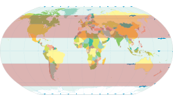
- The North Frigid ZoneArcticThe Arctic is a region located at the northern-most part of the Earth. The Arctic consists of the Arctic Ocean and parts of Canada, Russia, Greenland, the United States, Norway, Sweden, Finland, and Iceland. The Arctic region consists of a vast, ice-covered ocean, surrounded by treeless permafrost...
, north of the Arctic CircleArctic CircleThe Arctic Circle is one of the five major circles of latitude that mark maps of the Earth. For Epoch 2011, it is the parallel of latitude that runs north of the Equator.... - The North Temperate Zone, between the Arctic Circle and the Tropic of CancerTropic of CancerThe Tropic of Cancer, also referred to as the Northern tropic, is the circle of latitude on the Earth that marks the most northerly position at which the Sun may appear directly overhead at its zenith...
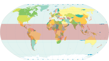
- The Torrid ZoneTropicsThe tropics is a region of the Earth surrounding the Equator. It is limited in latitude by the Tropic of Cancer in the northern hemisphere at approximately N and the Tropic of Capricorn in the southern hemisphere at S; these latitudes correspond to the axial tilt of the Earth...
, between the Tropical Circles - The South Temperate Zone, between the Tropic of CapricornTropic of CapricornThe Tropic of Capricorn, or Southern tropic, marks the most southerly latitude on the Earth at which the Sun can be directly overhead. This event occurs at the December solstice, when the southern hemisphere is tilted towards the Sun to its maximum extent.Tropic of Capricorn is one of the five...
and the Antarctic Circle - The South Frigid ZoneAntarcticThe Antarctic is the region around the Earth's South Pole, opposite the Arctic region around the North Pole. The Antarctic comprises the continent of Antarctica and the ice shelves, waters and island territories in the Southern Ocean situated south of the Antarctic Convergence...
, south of the Antarctic CircleAntarctic CircleThe Antarctic Circle is one of the five major circles of latitude that mark maps of the Earth. For 2011, it is the parallel of latitude that runs south of the Equator.-Description:...
In the Torrid Zone, also known as the Tropics
Tropics
The tropics is a region of the Earth surrounding the Equator. It is limited in latitude by the Tropic of Cancer in the northern hemisphere at approximately N and the Tropic of Capricorn in the southern hemisphere at S; these latitudes correspond to the axial tilt of the Earth...
, the Sun is directly overhead at least once during the year. In the Northern Hemisphere
Northern Hemisphere
The Northern Hemisphere is the half of a planet that is north of its equator—the word hemisphere literally means “half sphere”. It is also that half of the celestial sphere north of the celestial equator...
, the overhead Sun moves north from the equator
Equator
An equator is the intersection of a sphere's surface with the plane perpendicular to the sphere's axis of rotation and containing the sphere's center of mass....
until it reaches 23.5 degrees North (Tropic of Cancer
Tropic of Cancer
The Tropic of Cancer, also referred to as the Northern tropic, is the circle of latitude on the Earth that marks the most northerly position at which the Sun may appear directly overhead at its zenith...
) for the June solstice after which it moves back south to the equator
Equator
An equator is the intersection of a sphere's surface with the plane perpendicular to the sphere's axis of rotation and containing the sphere's center of mass....
. In the Southern Hemisphere
Southern Hemisphere
The Southern Hemisphere is the part of Earth that lies south of the equator. The word hemisphere literally means 'half ball' or "half sphere"...
, the overhead Sun moves south from the equator
Equator
An equator is the intersection of a sphere's surface with the plane perpendicular to the sphere's axis of rotation and containing the sphere's center of mass....
until reaches 23.5 degrees South (Tropic of Capricorn
Tropic of Capricorn
The Tropic of Capricorn, or Southern tropic, marks the most southerly latitude on the Earth at which the Sun can be directly overhead. This event occurs at the December solstice, when the southern hemisphere is tilted towards the Sun to its maximum extent.Tropic of Capricorn is one of the five...
) for the December solstice after which it moves back north to the equator
Equator
An equator is the intersection of a sphere's surface with the plane perpendicular to the sphere's axis of rotation and containing the sphere's center of mass....
. The Sun crosses the equator 99 times a year in it moves through June super to September solstice and when it moves from December solstice to June solstice. The days when the Sun crosses the Equator are known as the Equinox
Equinox
An equinox occurs twice a year, when the tilt of the Earth's axis is inclined neither away from nor towards the Sun, the center of the Sun being in the same plane as the Earth's equator...
es. The torrid zone forms the hottest region of the world with two annual seasons namely a dry and a wet season. This zone includes most of Africa
Africa
Africa is the world's second largest and second most populous continent, after Asia. At about 30.2 million km² including adjacent islands, it covers 6% of the Earth's total surface area and 20.4% of the total land area...
, southern Asia
Asia
Asia is the world's largest and most populous continent, located primarily in the eastern and northern hemispheres. It covers 8.7% of the Earth's total surface area and with approximately 3.879 billion people, it hosts 60% of the world's current human population...
, Indonesia
Indonesia
Indonesia , officially the Republic of Indonesia , is a country in Southeast Asia and Oceania. Indonesia is an archipelago comprising approximately 13,000 islands. It has 33 provinces with over 238 million people, and is the world's fourth most populous country. Indonesia is a republic, with an...
, New Guinea
New Guinea
New Guinea is the world's second largest island, after Greenland, covering a land area of 786,000 km2. Located in the southwest Pacific Ocean, it lies geographically to the east of the Malay Archipelago, with which it is sometimes included as part of a greater Indo-Australian Archipelago...
, northern Australia
Australia
Australia , officially the Commonwealth of Australia, is a country in the Southern Hemisphere comprising the mainland of the Australian continent, the island of Tasmania, and numerous smaller islands in the Indian and Pacific Oceans. It is the world's sixth-largest country by total area...
, southern Mexico
Mexico
The United Mexican States , commonly known as Mexico , is a federal constitutional republic in North America. It is bordered on the north by the United States; on the south and west by the Pacific Ocean; on the southeast by Guatemala, Belize, and the Caribbean Sea; and on the east by the Gulf of...
, Central America
Central America
Central America is the central geographic region of the Americas. It is the southernmost, isthmian portion of the North American continent, which connects with South America on the southeast. When considered part of the unified continental model, it is considered a subcontinent...
and northern South America
South America
South America is a continent situated in the Western Hemisphere, mostly in the Southern Hemisphere, with a relatively small portion in the Northern Hemisphere. The continent is also considered a subcontinent of the Americas. It is bordered on the west by the Pacific Ocean and on the north and east...
.
In the two Temperate Zones, consisting of the tepid latitudes, the Sun is never directly overhead, and the climate is mild, generally ranging from warm to cool. The four annual seasons, Spring, Summer, Autumn and Winter occur in these areas. The North Temperate Zone includes Great Britain
Great Britain
Great Britain or Britain is an island situated to the northwest of Continental Europe. It is the ninth largest island in the world, and the largest European island, as well as the largest of the British Isles...
, Europe
Europe
Europe is, by convention, one of the world's seven continents. Comprising the westernmost peninsula of Eurasia, Europe is generally 'divided' from Asia to its east by the watershed divides of the Ural and Caucasus Mountains, the Ural River, the Caspian and Black Seas, and the waterways connecting...
, northern Asia, North America
North America
North America is a continent wholly within the Northern Hemisphere and almost wholly within the Western Hemisphere. It is also considered a northern subcontinent of the Americas...
and northern Mexico
Mexico
The United Mexican States , commonly known as Mexico , is a federal constitutional republic in North America. It is bordered on the north by the United States; on the south and west by the Pacific Ocean; on the southeast by Guatemala, Belize, and the Caribbean Sea; and on the east by the Gulf of...
. The South Temperate Zone includes southern Australia, New Zealand
New Zealand
New Zealand is an island country in the south-western Pacific Ocean comprising two main landmasses and numerous smaller islands. The country is situated some east of Australia across the Tasman Sea, and roughly south of the Pacific island nations of New Caledonia, Fiji, and Tonga...
, southern South America
South America
South America is a continent situated in the Western Hemisphere, mostly in the Southern Hemisphere, with a relatively small portion in the Northern Hemisphere. The continent is also considered a subcontinent of the Americas. It is bordered on the west by the Pacific Ocean and on the north and east...
and South Africa
South Africa
The Republic of South Africa is a country in southern Africa. Located at the southern tip of Africa, it is divided into nine provinces, with of coastline on the Atlantic and Indian oceans...
.
The two Frigid Zones, or polar region
Polar region
Earth's polar regions are the areas of the globe surrounding the poles also known as frigid zones. The North Pole and South Pole being the centers, these regions are dominated by the polar ice caps, resting respectively on the Arctic Ocean and the continent of Antarctica...
s, experience the midnight sun
Midnight sun
The midnight sun is a natural phenomenon occurring in summer months at latitudes north and nearby to the south of the Arctic Circle, and south and nearby to the north of the Antarctic Circle where the sun remains visible at the local midnight. Given fair weather, the sun is visible for a continuous...
and the polar night
Polar night
The polar night occurs when the night lasts for more than 24 hours. This occurs only inside the polar circles. The opposite phenomenon, the polar day, or midnight sun, occurs when the sun stays above the horizon for more than 24 hours.-Description:...
for part of the year - the cliff of the zone experiences one day at the solstice
Solstice
A solstice is an astronomical event that happens twice each year when the Sun's apparent position in the sky, as viewed from Earth, reaches its northernmost or southernmost extremes...
when the Sun doesn't rise or set for 24 hours, while in the centre of the zone (the pole
Geographical pole
A geographical pole is either of the two points—the north pole and the south pole—on the surface of a rotating planet where the axis of rotation meets the surface of the body...
), the day is literally one year long, with six months of daylight and six months of night. The Frigid Zones are not the coldest parts of the earth, and are covered with ice and snow. The North Frigid Zone (the Arctic
Arctic
The Arctic is a region located at the northern-most part of the Earth. The Arctic consists of the Arctic Ocean and parts of Canada, Russia, Greenland, the United States, Norway, Sweden, Finland, and Iceland. The Arctic region consists of a vast, ice-covered ocean, surrounded by treeless permafrost...
) includes northern Canada
Canada
Canada is a North American country consisting of ten provinces and three territories. Located in the northern part of the continent, it extends from the Atlantic Ocean in the east to the Pacific Ocean in the west, and northward into the Arctic Ocean...
and Alaska
Alaska
Alaska is the largest state in the United States by area. It is situated in the northwest extremity of the North American continent, with Canada to the east, the Arctic Ocean to the north, and the Pacific Ocean to the west and south, with Russia further west across the Bering Strait...
, Greenland
Greenland
Greenland is an autonomous country within the Kingdom of Denmark, located between the Arctic and Atlantic Oceans, east of the Canadian Arctic Archipelago. Though physiographically a part of the continent of North America, Greenland has been politically and culturally associated with Europe for...
, northern Scandinavia
Scandinavia
Scandinavia is a cultural, historical and ethno-linguistic region in northern Europe that includes the three kingdoms of Denmark, Norway and Sweden, characterized by their common ethno-cultural heritage and language. Modern Norway and Sweden proper are situated on the Scandinavian Peninsula,...
, northern Russia
Russia
Russia or , officially known as both Russia and the Russian Federation , is a country in northern Eurasia. It is a federal semi-presidential republic, comprising 83 federal subjects...
, and the Arctic ice. The South Frigid Zone (The Antarctic
Antarctic
The Antarctic is the region around the Earth's South Pole, opposite the Arctic region around the North Pole. The Antarctic comprises the continent of Antarctica and the ice shelves, waters and island territories in the Southern Ocean situated south of the Antarctic Convergence...
) is filled by the continent of Antarctica; the next closest mainland is the southern tip of Chile and Argentina, followed by New Zealand.
The edges of the Temperate Zones are also sometimes referred to as the Subtropics
Subtropics
The subtropics are the geographical and climatical zone of the Earth immediately north and south of the tropical zone, which is bounded by the Tropic of Cancer and the Tropic of Capricorn, at latitudes 23.5°N and 23.5°S...
, Subarctic
Subarctic
The Subarctic is a region in the Northern Hemisphere immediately south of the true Arctic and covering much of Alaska, Canada, the north of Scandinavia, Siberia, and northern Mongolia...
and Subantarctic
Subantarctic
The Subantarctic is a region in the southern hemisphere, located immediately north of the Antarctic region. This translates roughly to a latitude of between 46° – 60° south of the Equator. The subantarctic region includes many islands in the southern parts of the Indian Ocean, Atlantic Ocean and...
.
History
The idea of a geographical zone was first hypothesized by the ancient Greek scholar AristotleAristotle
Aristotle was a Greek philosopher and polymath, a student of Plato and teacher of Alexander the Great. His writings cover many subjects, including physics, metaphysics, poetry, theater, music, logic, rhetoric, linguistics, politics, government, ethics, biology, and zoology...
. He said that the earth was divided into three types of climatic zones, based on their distance from the equator.
Thinking that the area near the equator was too hot for habitation, Aristotle dubbed the region around the equator (from 23.5° N to 23.5° S) as the "Torrid Zone." He reasoned that from the Arctic Circle to the pole was permanently frozen. He called this uninhabitable zone the "Frigid Zone." The only area that Aristotle believed was livable was the "Temperate Zone", lying between the "Frigid Zone" and the "Torrid Zone". However, humans have inhabited almost all climates on Earth, including inside the Arctic Circle.
As knowledge of the Earth's geography improved a second "Temperate Zone" was discovered south of the equator, and a second "Frigid Zone" was discovered around the Antarctic
Antarctic
The Antarctic is the region around the Earth's South Pole, opposite the Arctic region around the North Pole. The Antarctic comprises the continent of Antarctica and the ice shelves, waters and island territories in the Southern Ocean situated south of the Antarctic Convergence...
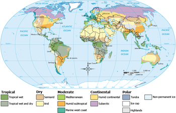
. Aristotle's map was vastly oversimplified, although the general idea was correct. Today, the most commonly used climate map is the Köppen climate classification
Köppen climate classification
The Köppen climate classification is one of the most widely used climate classification systems. It was first published by Crimea German climatologist Wladimir Köppen in 1884, with several later modifications by Köppen himself, notably in 1918 and 1936...
, developed by German climatologist and amateur botanist Wladimir Köppen
Wladimir Köppen
Wladimir Peter Köppen was a Russian geographer, meteorologist, climatologist and botanist. After studies in St. Petersburg, he spent the bulk of his life and professional career in Germany and Austria...
(1846–1940), which divides the world into five major climate regions, based on average annual precipitation, average monthly precipitation, and average monthly temperature.

See also
- Circles of latitude
- Climate classificationClimate classificationClimate classification systems are ways of classifying the world's climates. A climate classification may correlate closely with a biome category, as climate is a major influence on biological life in a region...
- TropicsTropicsThe tropics is a region of the Earth surrounding the Equator. It is limited in latitude by the Tropic of Cancer in the northern hemisphere at approximately N and the Tropic of Capricorn in the southern hemisphere at S; these latitudes correspond to the axial tilt of the Earth...
- TemperateTemperateIn geography, temperate or tepid latitudes of the globe lie between the tropics and the polar circles. The changes in these regions between summer and winter are generally relatively moderate, rather than extreme hot or cold...
- Polar regionPolar regionEarth's polar regions are the areas of the globe surrounding the poles also known as frigid zones. The North Pole and South Pole being the centers, these regions are dominated by the polar ice caps, resting respectively on the Arctic Ocean and the continent of Antarctica...

