Geography of Denmark
Encyclopedia
Denmark
is located in Western Europe (it is one of the Nordic countries
) on the Jutland
peninsula and several islands in the Baltic sea. It borders both the (Baltic Sea) and the North Sea
along its 7314 km (4,544.7 mi) tidal shoreline (including bays and inlets), whereas the general coastline is much shorter, at 1701 km (1,057 mi), as it would, among other geographical features, not include most of the 1,419 offshore islands (each defined as exceeding 100 square meters in area) and the 112 mile long Limfjorden, which separates Denmark's second largest island, North Jutlandic Island, 4,686 square km in size, from the rest of Jutland. Denmark has 443 named islands, of which 72 are inhabited . Denmark's size is comparable to that of Nova Scotia
. Denmark has a 68 km border with the German state of Schleswig-Holstein
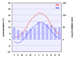
. Denmark experiences a temperate climate. This means that the winters are mild and windy and the summers are cool. The local terrain is generally flat with a few gently rolling plain
s. The territory of Denmark includes the island of Bornholm
in the Baltic Sea and the rest of metropolitan Denmark, but excludes the Faroe Islands
and Greenland
. Its position gives Denmark complete control of the Danish Straits
(Skagerrak
and Kattegat
) linking Baltic and North Seas. The country's natural resources include petroleum
, natural gas
, fish
, salt
, limestone
, stone
, gravel
and sand
.

Irrigated land: 4 350 km² (1993 est.)


.
Denmarks population is 5,529,270 based on a 2009 study
Denmark
Denmark is a Scandinavian country in Northern Europe. The countries of Denmark and Greenland, as well as the Faroe Islands, constitute the Kingdom of Denmark . It is the southernmost of the Nordic countries, southwest of Sweden and south of Norway, and bordered to the south by Germany. Denmark...
is located in Western Europe (it is one of the Nordic countries
Nordic countries
The Nordic countries make up a region in Northern Europe and the North Atlantic which consists of Denmark, Finland, Iceland, Norway and Sweden and their associated territories, the Faroe Islands, Greenland and Åland...
) on the Jutland
Jutland
Jutland , historically also called Cimbria, is the name of the peninsula that juts out in Northern Europe toward the rest of Scandinavia, forming the mainland part of Denmark. It has the North Sea to its west, Kattegat and Skagerrak to its north, the Baltic Sea to its east, and the Danish–German...
peninsula and several islands in the Baltic sea. It borders both the (Baltic Sea) and the North Sea
North Sea
In the southwest, beyond the Straits of Dover, the North Sea becomes the English Channel connecting to the Atlantic Ocean. In the east, it connects to the Baltic Sea via the Skagerrak and Kattegat, narrow straits that separate Denmark from Norway and Sweden respectively...
along its 7314 km (4,544.7 mi) tidal shoreline (including bays and inlets), whereas the general coastline is much shorter, at 1701 km (1,057 mi), as it would, among other geographical features, not include most of the 1,419 offshore islands (each defined as exceeding 100 square meters in area) and the 112 mile long Limfjorden, which separates Denmark's second largest island, North Jutlandic Island, 4,686 square km in size, from the rest of Jutland. Denmark has 443 named islands, of which 72 are inhabited . Denmark's size is comparable to that of Nova Scotia
Nova Scotia
Nova Scotia is one of Canada's three Maritime provinces and is the most populous province in Atlantic Canada. The name of the province is Latin for "New Scotland," but "Nova Scotia" is the recognized, English-language name of the province. The provincial capital is Halifax. Nova Scotia is the...
. Denmark has a 68 km border with the German state of Schleswig-Holstein
Schleswig-Holstein
Schleswig-Holstein is the northernmost of the sixteen states of Germany, comprising most of the historical duchy of Holstein and the southern part of the former Duchy of Schleswig...
. Denmark experiences a temperate climate. This means that the winters are mild and windy and the summers are cool. The local terrain is generally flat with a few gently rolling plain
Plain
In geography, a plain is land with relatively low relief, that is flat or gently rolling. Prairies and steppes are types of plains, and the archetype for a plain is often thought of as a grassland, but plains in their natural state may also be covered in shrublands, woodland and forest, or...
s. The territory of Denmark includes the island of Bornholm
Bornholm
Bornholm is a Danish island in the Baltic Sea located to the east of the rest of Denmark, the south of Sweden, and the north of Poland. The main industries on the island include fishing, arts and crafts like glass making and pottery using locally worked clay, and dairy farming. Tourism is...
in the Baltic Sea and the rest of metropolitan Denmark, but excludes the Faroe Islands
Faroe Islands
The Faroe Islands are an island group situated between the Norwegian Sea and the North Atlantic Ocean, approximately halfway between Scotland and Iceland. The Faroe Islands are a self-governing territory within the Kingdom of Denmark, along with Denmark proper and Greenland...
and Greenland
Greenland
Greenland is an autonomous country within the Kingdom of Denmark, located between the Arctic and Atlantic Oceans, east of the Canadian Arctic Archipelago. Though physiographically a part of the continent of North America, Greenland has been politically and culturally associated with Europe for...
. Its position gives Denmark complete control of the Danish Straits
Danish straits
The Danish straits are the three channels connecting the Baltic Sea to the North Sea through the Kattegat and Skagerrak. They transect Denmark, and are not to be confused with the Denmark Strait between Greenland and Iceland...
(Skagerrak
Skagerrak
The Skagerrak is a strait running between Norway and the southwest coast of Sweden and the Jutland peninsula of Denmark, connecting the North Sea and the Kattegat sea area, which leads to the Baltic Sea.-Name:...
and Kattegat
Kattegat
The Kattegat , or Kattegatt is a sea area bounded by the Jutland peninsula and the Straits islands of Denmark on the west and south, and the provinces of Västergötland, Scania, Halland and Bohuslän in Sweden on the east. The Baltic Sea drains into the Kattegat through the Øresund and the Danish...
) linking Baltic and North Seas. The country's natural resources include petroleum
Petroleum
Petroleum or crude oil is a naturally occurring, flammable liquid consisting of a complex mixture of hydrocarbons of various molecular weights and other liquid organic compounds, that are found in geologic formations beneath the Earth's surface. Petroleum is recovered mostly through oil drilling...
, natural gas
Natural gas
Natural gas is a naturally occurring gas mixture consisting primarily of methane, typically with 0–20% higher hydrocarbons . It is found associated with other hydrocarbon fuel, in coal beds, as methane clathrates, and is an important fuel source and a major feedstock for fertilizers.Most natural...
, fish
Fish
Fish are a paraphyletic group of organisms that consist of all gill-bearing aquatic vertebrate animals that lack limbs with digits. Included in this definition are the living hagfish, lampreys, and cartilaginous and bony fish, as well as various extinct related groups...
, salt
Salt
In chemistry, salts are ionic compounds that result from the neutralization reaction of an acid and a base. They are composed of cations and anions so that the product is electrically neutral...
, limestone
Limestone
Limestone is a sedimentary rock composed largely of the minerals calcite and aragonite, which are different crystal forms of calcium carbonate . Many limestones are composed from skeletal fragments of marine organisms such as coral or foraminifera....
, stone
Rock (geology)
In geology, rock or stone is a naturally occurring solid aggregate of minerals and/or mineraloids.The Earth's outer solid layer, the lithosphere, is made of rock. In general rocks are of three types, namely, igneous, sedimentary, and metamorphic...
, gravel
Gravel
Gravel is composed of unconsolidated rock fragments that have a general particle size range and include size classes from granule- to boulder-sized fragments. Gravel can be sub-categorized into granule and cobble...
and sand
Sand
Sand is a naturally occurring granular material composed of finely divided rock and mineral particles.The composition of sand is highly variable, depending on the local rock sources and conditions, but the most common constituent of sand in inland continental settings and non-tropical coastal...
.
Land use

- Arable landArable landIn geography and agriculture, arable land is land that can be used for growing crops. It includes all land under temporary crops , temporary meadows for mowing or pasture, land under market and kitchen gardens and land temporarily fallow...
: 60% - Permanent crops: 0%
- Permanent pastures: 5%
- Forests and woodland: 10%
- Other: 25% (1993 est.)
Irrigated land: 4 350 km² (1993 est.)
Current issues

- Air pollutionAir pollutionAir pollution is the introduction of chemicals, particulate matter, or biological materials that cause harm or discomfort to humans or other living organisms, or cause damage to the natural environment or built environment, into the atmosphere....
, principally from vehicle and power plant emissions - NitrogenNitrogenNitrogen is a chemical element that has the symbol N, atomic number of 7 and atomic mass 14.00674 u. Elemental nitrogen is a colorless, odorless, tasteless, and mostly inert diatomic gas at standard conditions, constituting 78.08% by volume of Earth's atmosphere...
and phosphorusPhosphorusPhosphorus is the chemical element that has the symbol P and atomic number 15. A multivalent nonmetal of the nitrogen group, phosphorus as a mineral is almost always present in its maximally oxidized state, as inorganic phosphate rocks...
pollution of the North Sea - Drinking and surface water becoming polluted from animal wastes and pesticides
International agreements
- Party to: Air Pollution, Air Pollution-Nitrogen Oxides,
Air Pollution-Sulphur 85, Air Pollution-Sulphur 94, Air Pollution-Volatile Organic Compounds, Antarctic Treaty, Biodiversity, Climate Change, Desertification, Endangered Species, Environmental Modification, Hazardous Wastes, Law of the SeaLaw of the seaLaw of the sea may refer to:* United Nations Convention on the Law of the Sea* Admiralty law* The Custom of the Sea...
, Marine Dumping, Marine Life Conservation, Nuclear Test Ban, Ozone Layer Protection, Ship Pollution, Tropical Timber 83, Tropical Timber 94, Wetlands, Whaling - Signed, but not ratified: Air Pollution-Persistent Organic Pollutants, Antarctic-Environmental Protocol, Climate Change-Kyoto Protocol
Maritime claims

- Contiguous zone: 24 nmi (44.4 km; 27.6 mi)
- Continental shelf: 200-m depth or to the depth of exploitation
- Exclusive economic zone: 200 nmi (370.4 km; 230.2 mi)
- Territorial sea: 12 nmi (22.2 km; 13.8 mi)
Other issues
- IcelandIcelandIceland , described as the Republic of Iceland, is a Nordic and European island country in the North Atlantic Ocean, on the Mid-Atlantic Ridge. Iceland also refers to the main island of the country, which contains almost all the population and almost all the land area. The country has a population...
disputes the Faroe IslandsFaroe IslandsThe Faroe Islands are an island group situated between the Norwegian Sea and the North Atlantic Ocean, approximately halfway between Scotland and Iceland. The Faroe Islands are a self-governing territory within the Kingdom of Denmark, along with Denmark proper and Greenland...
' fisheries median line. - Iceland, the United Kingdom and the Republic of Ireland dispute Denmark's claim that the Faroe Islands' continental shelfContinental shelfThe continental shelf is the extended perimeter of each continent and associated coastal plain. Much of the shelf was exposed during glacial periods, but is now submerged under relatively shallow seas and gulfs, and was similarly submerged during other interglacial periods. The continental margin,...
extends beyond 200 nautical miles or about 370 km. - The Faroe Islands continue to study proposals for full independence.
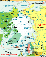
- Uncontested sovereignty dispute with Canada over Hans IslandHans IslandHans Island is a small, uninhabited barren knoll measuring , located in the centre of the Kennedy Channel of Nares Strait—the strait that separates Ellesmere Island from northern Greenland and connects Baffin Bay with the Lincoln Sea...
in the Kennedy ChannelKennedy ChannelKennedy Channel is an Arctic sea passage between Greenland and Canada's most northerly island, Ellesmere Island.It forms part of Nares Strait, linking Kane Basin with Hall Basin. From the south, its beginning is marked by Capes Lawrence and Jackson; its junction with Hall Basin is marked by Capes...
between Ellesmere IslandEllesmere IslandEllesmere Island is part of the Qikiqtaaluk Region of the Canadian territory of Nunavut. Lying within the Canadian Arctic Archipelago, it is considered part of the Queen Elizabeth Islands, with Cape Columbia being the most northerly point of land in Canada...
and GreenlandGreenlandGreenland is an autonomous country within the Kingdom of Denmark, located between the Arctic and Atlantic Oceans, east of the Canadian Arctic Archipelago. Though physiographically a part of the continent of North America, Greenland has been politically and culturally associated with Europe for...
. - Denmark and PolandPolandPoland , officially the Republic of Poland , is a country in Central Europe bordered by Germany to the west; the Czech Republic and Slovakia to the south; Ukraine, Belarus and Lithuania to the east; and the Baltic Sea and Kaliningrad Oblast, a Russian exclave, to the north...
have failed to reach an agreement settling the boundary between the two countries. - Denmark is currently investigating the extent of the continental shelf of Greenland, in the hope that Greenland's Exclusive Economic ZoneExclusive Economic ZoneUnder the law of the sea, an exclusive economic zone is a seazone over which a state has special rights over the exploration and use of marine resources, including production of energy from water and wind. It stretches from the seaward edge of the state's territorial sea out to 200 nautical...
can be expanded. One of the areas investigated is the geographical North PoleNorth PoleThe North Pole, also known as the Geographic North Pole or Terrestrial North Pole, is, subject to the caveats explained below, defined as the point in the northern hemisphere where the Earth's axis of rotation meets its surface...
.
Details

Population
About a quarter of Danes live in the capital CopenhagenCopenhagen
Copenhagen is the capital and largest city of Denmark, with an urban population of 1,199,224 and a metropolitan population of 1,930,260 . With the completion of the transnational Øresund Bridge in 2000, Copenhagen has become the centre of the increasingly integrating Øresund Region...
.
Denmarks population is 5,529,270 based on a 2009 study
See also
- List of islands of Denmark
- RigsfællesskabetRigsfællesskabetRigsfællesskabet is a semi-official Danish term for the relations between continental Denmark and its two self-governing insular regions, the Faroe Islands and Greenland, which collectively make up the Kingdom of Denmark.-Legal status:Both the Faroe Islands and Greenland enjoy far-reaching home...
- ISO 3166-2:DKISO 3166-2:DKISO 3166-2:DK is the entry for Denmark in ISO 3166-2, part of the ISO 3166 standard published by the International Organization for Standardization , which defines codes for the names of the principal subdivisions of all countries coded in ISO 3166-1.Currently for Denmark, ISO 3166-2 codes are...
- NUTS:DKNUTS:DKIn the NUTS codes of Denmark , the three levels are:-NUTS codes:In the 2003 version, before the counties were abolished, the codes were as follows:-Local administrative units:...
- UN/LOCODE:DKUN/LOCODE:DKThis is a list of UN/LOCODEs for Denmark.Note:*DKAUU Aulum and DKAVL Avlum are the same place.*There are two entries for Brønderslev DKBRO and DKBDV.-External links:*...

