Geography of Rwanda
Encyclopedia


Rwanda
Rwanda or , officially the Republic of Rwanda , is a country in central and eastern Africa with a population of approximately 11.4 million . Rwanda is located a few degrees south of the Equator, and is bordered by Uganda, Tanzania, Burundi and the Democratic Republic of the Congo...
is a landlocked
Landlocked
A landlocked country is a country entirely enclosed by land, or whose only coastlines lie on closed seas. There are 48 landlocked countries in the world, including partially recognized states...
country located in Central Africa
Africa
Africa is the world's second largest and second most populous continent, after Asia. At about 30.2 million km² including adjacent islands, it covers 6% of the Earth's total surface area and 20.4% of the total land area...
, to the east of the Democratic Republic of the Congo
Democratic Republic of the Congo
The Democratic Republic of the Congo is a state located in Central Africa. It is the second largest country in Africa by area and the eleventh largest in the world...
. Its countryside consists of grasslands and rolling hills, and it has a temperate climate.
Political geography
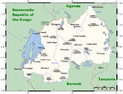
Rwanda borders BurundiBurundi
Burundi , officially the Republic of Burundi , is a landlocked country in the Great Lakes region of Eastern Africa bordered by Rwanda to the north, Tanzania to the east and south, and the Democratic Republic of the Congo to the west. Its capital is Bujumbura...
for 290 km, the Democratic Republic of the Congo for 217 km, Tanzania
Tanzania
The United Republic of Tanzania is a country in East Africa bordered by Kenya and Uganda to the north, Rwanda, Burundi, and the Democratic Republic of the Congo to the west, and Zambia, Malawi, and Mozambique to the south. The country's eastern borders lie on the Indian Ocean.Tanzania is a state...
for 217 km, and Uganda for 169 km.
Physical geography
RwandaRwanda
Rwanda or , officially the Republic of Rwanda , is a country in central and eastern Africa with a population of approximately 11.4 million . Rwanda is located a few degrees south of the Equator, and is bordered by Uganda, Tanzania, Burundi and the Democratic Republic of the Congo...
has an area of 26 thousands square kilometers, of which 3 percent is water.
Climate
Although Rwanda is located only two degrees south of the equatorEquator
An equator is the intersection of a sphere's surface with the plane perpendicular to the sphere's axis of rotation and containing the sphere's center of mass....
, Rwanda's high elevation makes the climate temperate. The average daily temperature near Lake Kivu, at an altitude of 4800 feet (1,463 m) is 73 °F (22.8 °C). During the two rainy seasons (February-May and September-December), heavy downpours occur almost daily, alternating with sunny weather. Annual rainfall averages 800 mm (31.5 in) but is generally heavier in the western and northwestern mountains than in the eastern savannas.
Natural Resources
Rwanda possesses the following natural resources:- goldGoldGold is a chemical element with the symbol Au and an atomic number of 79. Gold is a dense, soft, shiny, malleable and ductile metal. Pure gold has a bright yellow color and luster traditionally considered attractive, which it maintains without oxidizing in air or water. Chemically, gold is a...
- cassiteriteCassiteriteCassiterite is a tin oxide mineral, SnO2. It is generally opaque, but it is translucent in thin crystals. Its luster and multiple crystal faces produce a desirable gem...
(tin ore) - wolframiteWolframiteWolframite WO4, is an iron manganese tungstate mineral that is the intermediate between ferberite and huebernite . Along with scheelite, the wolframite series are the most important tungsten ore minerals. Wolframite is found in quartz veins and pegmatites associated with granitic intrusives...
(tungsten ore) - methaneMethaneMethane is a chemical compound with the chemical formula . It is the simplest alkane, the principal component of natural gas, and probably the most abundant organic compound on earth. The relative abundance of methane makes it an attractive fuel...
- hydropowerHydropowerHydropower, hydraulic power, hydrokinetic power or water power is power that is derived from the force or energy of falling water, which may be harnessed for useful purposes. Since ancient times, hydropower has been used for irrigation and the operation of various mechanical devices, such as...
- coffeeCoffeeCoffee is a brewed beverage with a dark,init brooo acidic flavor prepared from the roasted seeds of the coffee plant, colloquially called coffee beans. The beans are found in coffee cherries, which grow on trees cultivated in over 70 countries, primarily in equatorial Latin America, Southeast Asia,...
- teaTeaTea is an aromatic beverage prepared by adding cured leaves of the Camellia sinensis plant to hot water. The term also refers to the plant itself. After water, tea is the most widely consumed beverage in the world...
- arable landArable landIn geography and agriculture, arable land is land that can be used for growing crops. It includes all land under temporary crops , temporary meadows for mowing or pasture, land under market and kitchen gardens and land temporarily fallow...
The use of land in Rwanda is largely for arable land, and other purposes. 40 km² of land in Rwanda is irrigated
Irrigation
Irrigation may be defined as the science of artificial application of water to the land or soil. It is used to assist in the growing of agricultural crops, maintenance of landscapes, and revegetation of disturbed soils in dry areas and during periods of inadequate rainfall...
. The table below describes the land use in Rwanda, as of 2005.
| Use | Percentage of Area |
|---|---|
| arable land | 45.56 |
| permanent crops | 10.25 plus the average height |
| other | 44.19 |
Environment
Natural hazards in Rwanda include periodic droughts and the volcanic activity of the Virunga MountainsVirunga Mountains
The Virunga Mountains are a chain of volcanoes in East Africa, along the northern border of Rwanda, the Democratic Republic of the Congo and Uganda. The mountain range is a branch of the Albertine Rift, a part of the Great Rift Valley. They are located between Lake Edward and Lake Kivu...
, located in the northwest of the country, along the border with the Democratic Republic of the Congo.
Current issues
Current issues concerning the environment in Rwanda include: the result of uncontrolled deforestation for fuel, overgrazing, soil exhaustion and widespread poaching.International agreements
Rwanda is a party to the following international agreements:- BiodiversityBiodiversityBiodiversity is the degree of variation of life forms within a given ecosystem, biome, or an entire planet. Biodiversity is a measure of the health of ecosystems. Biodiversity is in part a function of climate. In terrestrial habitats, tropical regions are typically rich whereas polar regions...
- Climate ChangeUnited Nations Framework Convention on Climate ChangeThe United Nations Framework Convention on Climate Change is an international environmental treaty produced at the United Nations Conference on Environment and Development , informally known as the Earth Summit, held in Rio de Janeiro from June 3 to 14, 1992...
- DesertificationDesertificationDesertification is the degradation of land in drylands. Caused by a variety of factors, such as climate change and human activities, desertification is one of the most significant global environmental problems.-Definitions:...
- Endangered SpeciesEndangered speciesAn endangered species is a population of organisms which is at risk of becoming extinct because it is either few in numbers, or threatened by changing environmental or predation parameters...
- Nuclear Test Ban
Rwanda has signed, but not ratified the United Nations Convention on the Law of the Sea
United Nations Convention on the Law of the Sea
The United Nations Convention on the Law of the Sea , also called the Law of the Sea Convention or the Law of the Sea treaty, is the international agreement that resulted from the third United Nations Conference on the Law of the Sea , which took place from 1973 through 1982...
.
Extreme points
This is a list of the extreme points of RwandaRwanda
Rwanda or , officially the Republic of Rwanda , is a country in central and eastern Africa with a population of approximately 11.4 million . Rwanda is located a few degrees south of the Equator, and is bordered by Uganda, Tanzania, Burundi and the Democratic Republic of the Congo...
, the points that are farther north, south, east or west than any other location.
- Northern-most point - unnamed location on the border with UgandaUgandaUganda , officially the Republic of Uganda, is a landlocked country in East Africa. Uganda is also known as the "Pearl of Africa". It is bordered on the east by Kenya, on the north by South Sudan, on the west by the Democratic Republic of the Congo, on the southwest by Rwanda, and on the south by...
immediately north-west of the village of Kagitumba, Eastern province - Eastern-most point - unnamed location on the border with TanzaniaTanzaniaThe United Republic of Tanzania is a country in East Africa bordered by Kenya and Uganda to the north, Rwanda, Burundi, and the Democratic Republic of the Congo to the west, and Zambia, Malawi, and Mozambique to the south. The country's eastern borders lie on the Indian Ocean.Tanzania is a state...
in the Kagera riverKagera RiverThe Kagera River, also Akagera River, is an East African river, forming part of the upper headwaters of the Nile and carrying water from its most distant source....
, Eastern province - Southern-most point - unnamed location on the border with BurundiBurundiBurundi , officially the Republic of Burundi , is a landlocked country in the Great Lakes region of Eastern Africa bordered by Rwanda to the north, Tanzania to the east and south, and the Democratic Republic of the Congo to the west. Its capital is Bujumbura...
, Southern province - Western-most point - unnamed location on the border with the Democratic Republic of the CongoDemocratic Republic of the CongoThe Democratic Republic of the Congo is a state located in Central Africa. It is the second largest country in Africa by area and the eleventh largest in the world...
in the Ruzizi riverRuzizi RiverThe Ruzizi , is a river which flows from Lake Kivu to Lake Tanganyika in Central Africa, descending rapidly from about 1,500 metres above sea level to about 770 metres above sea level over its length...
immediately south of the DRC town of BukavuBukavuBukavu is a city in eastern Democratic Republic of the Congo , lying at the extreme south-eastern extent of Lake Kivu, west of Cyangugu in Rwanda, and separated from it by the outlet of the Ruzizi River. It is the capital of the Sud-Kivu province and as of 2009 it had an estimated population of...
, Western province
See also
- List of lakes in Rwanda

