Georgia State Route 43
Encyclopedia
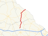
State Route 43 is a north–south state route located in the eastern part of the U.S. state
of Georgia
. The route travels from U.S. Route 78
/State Route 10/State Route 17 north of Thomson
north to the South Carolina
state line northeast of Lincolnton
.
, State Route 43 travels north. It passes over a branch of Strom Thurmond Lake, and enters Lincoln County
. The route intersects State Route 220 in the southern portion of the county, and then continues north to Lincolnton, the county seat. In Lincolnton, State Route 43 becomes briefly cosigned
with State Route 47. The two routes travel a short distance west to meet U.S. Route 378
. At the intersection, State Routes 43 and 47 diverge; State Route 43 becomes cosigned with U.S. 378 northeast of the city, and SR 47 becomes cosigned with U.S. 378 west of the city. U.S. 378 and SR 43 remained cosigned to the South Carolina state line, where State Route 43 meets its northern terminus.
State Route 43 is a rural route, serving mostly to connect the cities of Lincolnton and Thomson. The route sees an Average Annual Daily Traffic of less than 5,000 vehicles over its entire length.
U.S. state
A U.S. state is any one of the 50 federated states of the United States of America that share sovereignty with the federal government. Because of this shared sovereignty, an American is a citizen both of the federal entity and of his or her state of domicile. Four states use the official title of...
of Georgia
Georgia (U.S. state)
Georgia is a state located in the southeastern United States. It was established in 1732, the last of the original Thirteen Colonies. The state is named after King George II of Great Britain. Georgia was the fourth state to ratify the United States Constitution, on January 2, 1788...
. The route travels from U.S. Route 78
U.S. Route 78
U.S. Highway 78 is an east–west United States highway that runs for 715 miles from Memphis, Tennessee, to Charleston, South Carolina. Between Memphis and Birmingham, Alabama, it is being upgraded to become Interstate 22....
/State Route 10/State Route 17 north of Thomson
Thomson, Georgia
Thomson, incorporated February 15, 1854, is a city in McDuffie County, Georgia, United States. The population was 6,828 at the 2000 census. The city is the county seat of McDuffie County. Thomson's nickname is "The Camellia City of the South", in honor of the thousands of camellia plants...
north to the South Carolina
South Carolina
South Carolina is a state in the Deep South of the United States that borders Georgia to the south, North Carolina to the north, and the Atlantic Ocean to the east. Originally part of the Province of Carolina, the Province of South Carolina was one of the 13 colonies that declared independence...
state line northeast of Lincolnton
Lincolnton, Georgia
Lincolnton is a city in and the county seat of Lincoln County, Georgia, United States. The population was 1,595 at the 2000 census. It is the location for the historical site, Elijah Clark State Park, and contains numerous houses and historic districts listed on the National Register of Historic...
.
Route description
From its southern terminus at U.S. 78/SR 10/SR 17 north of Thomson in McDuffie CountyMcDuffie County, Georgia
McDuffie County is a county located in the U.S. state of Georgia. It was created on October 18, 1870. As of 2000, the population was 21,231. The 2007 Census Estimate showed a population of 21,551. The county seat is Thomson....
, State Route 43 travels north. It passes over a branch of Strom Thurmond Lake, and enters Lincoln County
Lincoln County, Georgia
Lincoln County is a county located in the U.S. state of Georgia, with the Savannah River forming its northeastern border. Located above the fall line, it is part of the Central Savannah River Area and a member of the CSRA Regional Development Center. The county was created on February 20, 1796. ...
. The route intersects State Route 220 in the southern portion of the county, and then continues north to Lincolnton, the county seat. In Lincolnton, State Route 43 becomes briefly cosigned
Concurrency (road)
A concurrency, overlap, or coincidence in a road network is an instance of one physical road bearing two or more different highway, motorway, or other route numbers...
with State Route 47. The two routes travel a short distance west to meet U.S. Route 378
U.S. Route 378
U.S. Route 378 is a spur of U.S. Route 78. It currently runs for 234 miles from Conway, South Carolina at U.S. Route 501 to Washington, Georgia at U.S. Route 78.-Route description:...
. At the intersection, State Routes 43 and 47 diverge; State Route 43 becomes cosigned with U.S. 378 northeast of the city, and SR 47 becomes cosigned with U.S. 378 west of the city. U.S. 378 and SR 43 remained cosigned to the South Carolina state line, where State Route 43 meets its northern terminus.
State Route 43 is a rural route, serving mostly to connect the cities of Lincolnton and Thomson. The route sees an Average Annual Daily Traffic of less than 5,000 vehicles over its entire length.

