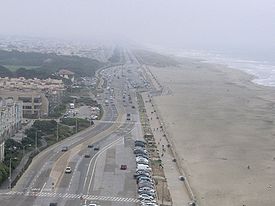
Great Highway
Encyclopedia

Road
A road is a thoroughfare, route, or way on land between two places, which typically has been paved or otherwise improved to allow travel by some conveyance, including a horse, cart, or motor vehicle. Roads consist of one, or sometimes two, roadways each with one or more lanes and also any...
in San Francisco that forms the city's western edge along the Pacific
Pacific Ocean
The Pacific Ocean is the largest of the Earth's oceanic divisions. It extends from the Arctic in the north to the Southern Ocean in the south, bounded by Asia and Australia in the west, and the Americas in the east.At 165.2 million square kilometres in area, this largest division of the World...
coast. It runs for approximately 3.5 miles (5.6 km) next to Ocean Beach
Ocean Beach, San Francisco, California
Ocean Beach is a beach that runs along the west coast of San Francisco, California, United States, at the Pacific Ocean. It is adjacent to Golden Gate Park, the Richmond District and the Sunset District. The Great Highway runs alongside the beach, and Cliff House and the site of the former Sutro...
. Its southern end is at Skyline Boulevard (State Route 35
California State Route 35
State Route 35 in the U.S. state of California, generally known as Skyline Boulevard, is a two-lane road running along the western ridge of Silicon Valley in California. It runs from Highway 17 to San Francisco at State Route 1. It provides scenic views of both the Santa Cruz Mountains, the...
) near Lake Merced
Lake Merced
Lake Merced is a freshwater lake in the southwest corner of San Francisco. It is surrounded by three golf courses , as well as residential areas, Lowell High School, San Francisco State University, Fort Funston and the Pacific Ocean...
; it extends to Point Lobos Avenue and the Cliff House
Cliff House
Cliff House may refer to:* Cliff House, the official residence of Chief Minister of Indian State of Kerala*Cliff House , a restaurant*The Cliff House , a condominium complex developed by the father of 47th U.S...
at its northern end.
The Great Highway also forms the western border of Golden Gate Park
Golden Gate Park
Golden Gate Park, located in San Francisco, California, is a large urban park consisting of of public grounds. Configured as a rectangle, it is similar in shape but 20% larger than Central Park in New York, to which it is often compared. It is over three miles long east to west, and about half a...
.
For approximately half its length, from Sloat Boulevard to Lincoln Way, the Great Highway is both an expressway
Limited-access road
A limited-access road known by various terms worldwide, including limited-access highway, dual-carriageway and expressway, is a highway or arterial road for high-speed traffic which has many or most characteristics of a controlled-access highway , including limited or no access to adjacent...
and a parallel street. The expressway is built atop a raised berm
Berm
A berm is a level space, shelf, or raised barrier separating two areas. Berm originates in the Middle Dutch and German berme and came into usage in English via French.- History :...
, which overlays a pre-existing wall built to keep the adjacent area clear from frequent encroachment by sand dunes. Also atop the berm is a gravel jogging path and a cement walking / bicycling path. The parallel street, also named 'Great Highway', is immediately adjacent below and to the east of the expressway, with buildings on its east side. The only access to the upper-level highway is at each end. There are crosswalks with traffic light
Traffic light
Traffic lights, which may also be known as stoplights, traffic lamps, traffic signals, signal lights, robots or semaphore, are signalling devices positioned at road intersections, pedestrian crossings and other locations to control competing flows of traffic...
s along this section to allow pedestrian
Pedestrian
A pedestrian is a person traveling on foot, whether walking or running. In some communities, those traveling using roller skates or skateboards are also considered to be pedestrians. In modern times, the term mostly refers to someone walking on a road or footpath, but this was not the case...
s to reach the beach.
The 'Dutch Windmill
Windmill
A windmill is a machine which converts the energy of wind into rotational energy by means of vanes called sails or blades. Originally windmills were developed for milling grain for food production. In the course of history the windmill was adapted to many other industrial uses. An important...
' is situated in the north western corner of the park near the intersection of Fulton Street and the Great Highway, and the 'Murphy Windmill' sits in the south western corner near Lincoln Way; both were built to pump water into Golden Gate Park. The N Judah
N Judah
The N Judah is a Muni Metro line in San Francisco, California, so called as it runs along Judah Street for much of its length, named after railroad engineer Theodore Judah. It links downtown San Francisco to the Cole Valley and Sunset neighborhoods. It is the busiest line in the Muni Metro system...
, a San Francisco Municipal Railway
San Francisco Municipal Railway
The San Francisco Municipal Railway is the public transit system for the city and county of San Francisco, California. In 2006, it served with an operating budget of about $700 million...
streetcar line, ends at Great Highway and Judah, while the L Taraval
L Taraval
The L Taraval is a Muni Metro line in San Francisco, California, mainly serving the Parkside District, an area which is immediately south of the Sunset District and which is regarded by some as the southern part of the Sunset District...
, another streetcar line, ends two blocks from Great Highway at Wawona and 46th Avenue.

