

Hot Creek Range
Encyclopedia
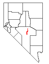

Nye County, Nevada
-National protected areas:* Ash Meadows National Wildlife Refuge* Death Valley National Park * Humboldt-Toiyabe National Forest * Spring Mountains National Recreation Area -Demographics:...
, in central Nevada
Nevada
Nevada is a state in the western, mountain west, and southwestern regions of the United States. With an area of and a population of about 2.7 million, it is the 7th-largest and 35th-most populous state. Over two-thirds of Nevada's people live in the Las Vegas metropolitan area, which contains its...
in the western United States
United States
The United States of America is a federal constitutional republic comprising fifty states and a federal district...
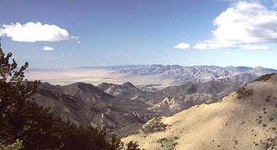
. From the historic community of Warm Springs, the range runs north-northeast for approximately 43 miles (69 km).
To the west are Stone Canyon Valley, Little Fish Lake Valley, and the large Monitor Range
Monitor Range
The Monitor Range is located in south-central Nevada in the United States. The range lies west and northwest of the Hot Creek Range and north of Highway 6 in Nye County, and extends for approximately 106 miles into Eureka County at its northern end.The Forest Service is in charge of 83.6% of the...
. To the east are Hot Creek Valley, Big Sand Springs Valley, and the Lunar Craters Volcanic Field. Further east lies the large Railroad Valley
Railroad Valley
Railroad Valley is one of the Central Nevada Desert Basins in the Tonopah Basin and is ~80 miles long north-south and up to 20 miles wide, with some southern areas running southwest to northeast. The southern end of the valley begins near Gray Top Mountain and stretches north all the way to...
, and the Grant
Grant Range
The Grant Range is a mountain chain in east-central Nevada in the western United States. It runs for approximately 30 miles in a generally north-south direction in northeastern Nye County. It is located south of the Horse Range and northeast of the closely associated Quinn Canyon Range. To the...
and Quinn Canyon
Quinn Canyon Range
The Quinn Canyon Range is a remote group of mountains in northeastern Nye County, in central Nevada in the western United States.It is closely associated with the Grant Range, which meets it at Cherry Creek Summit . From there, the range runs for approximately 33 miles to the southwest...
Ranges. Highway 6
U.S. Route 6
U.S. Route 6 , also called the Grand Army of the Republic Highway, a name that honors an American Civil War veterans association, is a main route of the U.S. Highway system, running east-northeast from Bishop, California to Provincetown, Massachusetts. Until 1964, it continued south from Bishop to...
passes south of the range at 6293-foot (1918 m) Warm Springs Summit. To the north, the range almost merges with the smaller Antelope
Antelope Range
The United States contains a number of mountain ranges named Antelope :...
and Park
Park Range (Nevada)
The Park Range is a mountain range in Nye County, Nevada....
Ranges.
The northern section of the Hot Creek Range has two distinct crests. The eastern crest rises to Morey Peak (10,246 feet, 3123 m), the highest point of the range. Nearby is the historic silver mining district of Moores Station. The western crest, across Sixmile Canyon, includes Mahogany Peak (9825 feet, 2995 m), Hot Creek Canyon, and the rugged Fandango Wilderness Study Area.