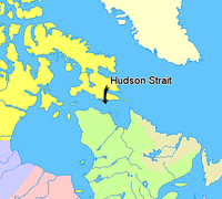


to Hudson Bay
in Canada
. It lies between Baffin Island
and the northern coast of Quebec
, its eastern entrance marked by Cape Chidley
and Resolution Island
. It is 450 mi (724.2 km) long. Its width varies from 150 mi (241.4 km) at its largest point, to a minimum of 40 mi (64.4 km).
Discovered by explorer Henry Hudson
in the year 1610 aboard the British ship Discovery, it was long thought to be the fabled Northwest Passage
.
Extent
The International Hydrographic Organizationdefines the limits of the Hudson Strait as follows:
On the West. A line from Nuvuk Point (62°21′N 78°06′W) to Leyson Point, thence by the Eastern shore of Southampton IslandSouthampton IslandSouthampton Island is a large island at the entrance to Hudson Bay at Foxe Basin. One of the larger members of the Canadian Arctic Archipelago, Southampton Island is part of the Kivalliq Region in Nunavut, Canada. The area of the island is stated as by Statistics Canada . It is the 34th largest...
to Seahorse Point, its Eastern extreme, thence a line to Lloyd Point (64°25′N 78°07′W) Baffin IslandBaffin IslandBaffin Island in the Canadian territory of Nunavut is the largest island in the Canadian Arctic Archipelago, the largest island in Canada and the fifth largest island in the world. Its area is and its population is about 11,000...
.
On the North. The South coast of Baffin Island between Lloyd Point and East Bluff.
On the East. A line from East Bluff, the Southeast extreme of Baffin Island (61°53′N 65°57′W), to Point Meridian, the Western extreme of Lower Savage Islands
Lower Savage IslandsThe Lower Savage Islands are an uninhabited offshore island group of Baffin Island, located in the Canadian Arctic Archipelago in the territory of Nunavut. The islands lie in...
, along the coast to its Southwestern extreme and thence a line across to the Western extreme of Resolution IslandResolution Island (Nunavut)Resolution Island is one of the many uninhabited Canadian Arctic islands in Qikiqtaaluk Region, Nunavut. It is a Baffin Island offshore island located in Hudson Strait. It has an area of...
, through its Southwestern shore to Hatton Headland, its Southern point, thence a line to Cape ChidleyCape ChidleyCape Chidley is a headland located on the eastern shore of Killiniq Island, Canada at the northeastern tip of the Labrador Peninsula.-Cape Chidley:...
, LabradorLabradorLabrador is the distinct, northerly region of the Canadian province of Newfoundland and Labrador. It comprises the mainland portion of the province, separated from the island of Newfoundland by the Strait of Belle Isle...
(60°24′N 64°26′W).
On the South. The mainland between Cape Chidley and Nuvuk Point.

