Inner London
Encyclopedia
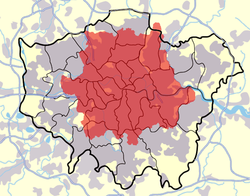
Inner London is the name for the group of London boroughs which form the interior part of Greater London
and are surrounded by Outer London
. The area was first officially defined in 1965 and for purposes such as statistics, the definition has changed over time. The terms Inner London and Central London
cannot be used interchangeably to mean the same area. Inner London is officially the richest area in Europe with the most expensive street in Europe, GDP per capita is nearly $80,000 while the UK GDP per capita is nearly $46,000. Many of the world's richest people live in West and North London, but there is widespread poverty too in these areas as well as the East End and areas south of the river
.
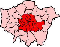
The inner London boroughs were defined by the London Government Act 1963
, and the definition is used for purposes such as the local government finance system. They correspond to the former area of the County of London
. These inner London boroughs are:
The City of London
was not part of the County of London and is not a London Borough but can be included. North Woolwich
is an anomaly as it was part of the County of London
but was transferred to Newham, an outer London borough, in 1965.
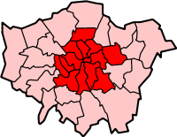
and the Census
define Inner London differently, adding Haringey
and Newham
, but excluding Greenwich
. This definition is also used by Eurostat
at NUTS
level 2. The land area is 319 km2 (123 sq. miles) and the population in 2005 (midyear estimate) was 2,985,700.
 The area covered by the London postal district
is sometimes referred to as 'Inner London'. However it is not coterminous with other definitions of Inner London as its area is somewhat larger and covers 624 km2 (241 sq. miles). A small part of the London Borough of Lewisham
falls outside its boundaries whilst 44 of its 119 districts are in Outer London and its irregular shape stretches to the Greater London boundary at Scratch Wood and beyond it at Sewardstone
.
From 1990 to 2000 London used two separate telephone dialling codes with one code designated for Inner London, however the area covered by this code was widely different from all of the above definitions and most of Greater London is now covered by a single 020 dialling code.
The term can also be used in a variety of other contexts with different meanings.
is seeking recognition as an Inner London borough for central government grants, as this would have financial benefits for the borough. It is not currently considered an Inner London Borough as, with the exception of North Woolwich
, it did not form part of the County of London.
Greater London
Greater London is the top-level administrative division of England covering London. It was created in 1965 and spans the City of London, including Middle Temple and Inner Temple, and the 32 London boroughs. This territory is coterminate with the London Government Office Region and the London...
and are surrounded by Outer London
Outer London
Outer London is the name for the group of London Boroughs that form a ring around Inner London.These were areas that were not part of the County of London and became formally part of Greater London in 1965...
. The area was first officially defined in 1965 and for purposes such as statistics, the definition has changed over time. The terms Inner London and Central London
Central London
Central London is the innermost part of London, England. There is no official or commonly accepted definition of its area, but its characteristics are understood to include a high density built environment, high land values, an elevated daytime population and a concentration of regionally,...
cannot be used interchangeably to mean the same area. Inner London is officially the richest area in Europe with the most expensive street in Europe, GDP per capita is nearly $80,000 while the UK GDP per capita is nearly $46,000. Many of the world's richest people live in West and North London, but there is widespread poverty too in these areas as well as the East End and areas south of the river
South London
South London is the southern part of London, England, United Kingdom.According to the 2011 official Boundary Commission for England definition, South London includes the London boroughs of Bexley, Bromley, Croydon, Greenwich, Kingston, Lambeth, Lewisham, Merton, Southwark, Sutton and...
.
London Government Act 1963
| Inner London - Primary Definition | |
 | |
| ONS Office for National Statistics The Office for National Statistics is the executive office of the UK Statistics Authority, a non-ministerial department which reports directly to the Parliament of the United Kingdom.- Overview :... 's Inner London | |
 |
The inner London boroughs were defined by the London Government Act 1963
London Government Act 1963
The London Government Act 1963 is an Act of the Parliament of the United Kingdom, which recognised officially the conurbation known as Greater London and created a new local government structure for the capital. The Act significantly reduced the number of local government districts in the area,...
, and the definition is used for purposes such as the local government finance system. They correspond to the former area of the County of London
County of London
The County of London was a county of England from 1889 to 1965, corresponding to the area known today as Inner London. It was created as part of the general introduction of elected county government in England, by way of the Local Government Act 1888. The Act created an administrative County of...
. These inner London boroughs are:
- CamdenLondon Borough of CamdenIn 1801, the civil parishes that form the modern borough were already developed and had a total population of 96,795. This continued to rise swiftly throughout the 19th century, as the district became built up; reaching 270,197 in the middle of the century...
- GreenwichLondon Borough of GreenwichThe London Borough of Greenwich is an Inner London borough in south-east London, England. Taking its name from the historic town of Greenwich, the present borough was formed in 1965 by the amalgamation of the former area of the Metropolitan Borough of Greenwich with part of the Metropolitan...
- HackneyLondon Borough of HackneyThe London Borough of Hackney is a London borough of North/North East London, and forms part of inner London. The local authority is Hackney London Borough Council....
- Hammersmith and FulhamLondon Borough of Hammersmith and FulhamThe London Borough of Hammersmith and Fulham is a London borough in West London, and forms part of Inner London. Traversed by the east-west main roads of the A4 Great West Road and the A40 Westway, many international corporations have offices in the borough....
- IslingtonLondon Borough of IslingtonThe London Borough of Islington is a London borough in Inner London. It was formed in 1965 by merging the former metropolitan boroughs of Islington and Finsbury. The borough contains two Westminster parliamentary constituencies, Islington North and Islington South & Finsbury...
- Kensington and ChelseaRoyal Borough of Kensington and ChelseaThe Royal Borough of Kensington and Chelsea is a central London borough of Royal borough status. After the City of Westminster, it is the wealthiest borough in England....
- LambethLondon Borough of LambethThe London Borough of Lambeth is a London borough in south London, England and forms part of Inner London. The local authority is Lambeth London Borough Council.-Origins:...
- LewishamLondon Borough of LewishamThe London Borough of Lewisham is a London borough in south-east London, England and forms part of Inner London. The principal settlement of the borough is Lewisham...
- SouthwarkLondon Borough of SouthwarkThe London Borough of Southwark is a London borough in south east London, England. It is directly south of the River Thames and the City of London, and forms part of Inner London.-History:...
- Tower HamletsLondon Borough of Tower HamletsThe London Borough of Tower Hamlets is a London borough to the east of the City of London and north of the River Thames. It is in the eastern part of London and covers much of the traditional East End. It also includes much of the redeveloped Docklands region of London, including West India Docks...
- WandsworthLondon Borough of WandsworthThe London Borough of Wandsworth is a London borough in southwest London, England, and forms part of Inner London.-History:The borough was formed in 1965 from the former area of the Metropolitan Borough of Battersea and much of the former area of the Metropolitan Borough of Wandsworth, but...
- WestminsterCity of WestminsterThe City of Westminster is a London borough occupying much of the central area of London, England, including most of the West End. It is located to the west of and adjoining the ancient City of London, directly to the east of the Royal Borough of Kensington and Chelsea, and its southern boundary...
The City of London
City of London
The City of London is a small area within Greater London, England. It is the historic core of London around which the modern conurbation grew and has held city status since time immemorial. The City’s boundaries have remained almost unchanged since the Middle Ages, and it is now only a tiny part of...
was not part of the County of London and is not a London Borough but can be included. North Woolwich
North Woolwich
North Woolwich is a place in the London Borough of Newham. It is located north of Woolwich proper which is on the south bank of the River Thames. The two places are linked by the Woolwich Ferry and the Woolwich foot tunnel.-History:...
is an anomaly as it was part of the County of London
County of London
The County of London was a county of England from 1889 to 1965, corresponding to the area known today as Inner London. It was created as part of the general introduction of elected county government in England, by way of the Local Government Act 1888. The Act created an administrative County of...
but was transferred to Newham, an outer London borough, in 1965.
ONS definition (statistics)
The Office for National StatisticsOffice for National Statistics
The Office for National Statistics is the executive office of the UK Statistics Authority, a non-ministerial department which reports directly to the Parliament of the United Kingdom.- Overview :...
and the Census
Census
A census is the procedure of systematically acquiring and recording information about the members of a given population. It is a regularly occurring and official count of a particular population. The term is used mostly in connection with national population and housing censuses; other common...
define Inner London differently, adding Haringey
London Borough of Haringey
The London Borough of Haringey is a London borough, in North London, classified by some definitions as part of Inner London, and by others as part of Outer London. It was created in 1965 by the amalgamation of three former boroughs. It shares borders with six other London boroughs...
and Newham
London Borough of Newham
The London Borough of Newham is a London borough formed from the towns of West Ham and East Ham, within East London.It is situated east of the City of London, and is north of the River Thames. According to 2006 estimates, Newham has one of the highest ethnic minority populations of all the...
, but excluding Greenwich
London Borough of Greenwich
The London Borough of Greenwich is an Inner London borough in south-east London, England. Taking its name from the historic town of Greenwich, the present borough was formed in 1965 by the amalgamation of the former area of the Metropolitan Borough of Greenwich with part of the Metropolitan...
. This definition is also used by Eurostat
Eurostat
Eurostat is a Directorate-General of the European Commission located in Luxembourg. Its main responsibilities are to provide the European Union with statistical information at European level and to promote the integration of statistical methods across the Member States of the European Union,...
at NUTS
NUTS:UK
In the NUTS codes of the United Kingdom , the three levels are:-NUTS codes:...
level 2. The land area is 319 km2 (123 sq. miles) and the population in 2005 (midyear estimate) was 2,985,700.
Historical population
Figures before 1971 have been reconstructed by the Office for National Statistics based on past censuses in order to fit the 2001 limits. Figures from 1981 onward are ONS midyear estimates (revised as of 2010).| Date | Population |
|---|---|
| 1891, April 5/6 | 4,488,242 |
| 1901, March 31/April 1 | 4,859,558 |
| 1911, April 2/3 | 4,998,237 |
| 1921, June 19/20 | 4,972,870 |
| 1931, April 26/27 | 4,893,261 |
| 1939, Midyear estimate | 4,364,457 |
| 1951, April 8/9 | 3,679,390 |
| 1961, April 23/24 | 3,492,879 |
| 1971, April 25/26 | 3,031,935 |
| 1981, Midyear estimate | 2,550,100 |
| 1991, Midyear estimate | 2,599,300 |
| 2001, Midyear estimate | 2,859,400 |
| 2002, Midyear estimate | 2,888,800 |
| 2003, Midyear estimate | 2,894,400 |
| 2004, Midyear estimate | 2,911,800 |
| 2005, Midyear estimate | 2,947,800 |
| 2006, Midyear estimate | 2,975,800 |
| 2007, Midyear estimate | 3,003,400 |
| 2008, Midyear estimate | 3,030,000 |
| 2009, Midyear estimate | 3,061,000 |
Other definitions

London postal district
The London postal district is the area in England, currently of , to which mail addressed to the LONDON post town is delivered. The area was initially devised in 1856 and throughout its history has been subject to periodic reorganisation, contraction and division into increasingly smaller postal...
is sometimes referred to as 'Inner London'. However it is not coterminous with other definitions of Inner London as its area is somewhat larger and covers 624 km2 (241 sq. miles). A small part of the London Borough of Lewisham
London Borough of Lewisham
The London Borough of Lewisham is a London borough in south-east London, England and forms part of Inner London. The principal settlement of the borough is Lewisham...
falls outside its boundaries whilst 44 of its 119 districts are in Outer London and its irregular shape stretches to the Greater London boundary at Scratch Wood and beyond it at Sewardstone
Sewardstone
Sewardstone is a place in the Epping Forest district of Essex, England.It is located 11.6 miles north north-east of Charing Cross and is the only area outside Greater London to be covered by a London postcode district . The area consists of scattered development with large sections of open land...
.
From 1990 to 2000 London used two separate telephone dialling codes with one code designated for Inner London, however the area covered by this code was widely different from all of the above definitions and most of Greater London is now covered by a single 020 dialling code.
The term can also be used in a variety of other contexts with different meanings.
Funding
The London Borough of NewhamLondon Borough of Newham
The London Borough of Newham is a London borough formed from the towns of West Ham and East Ham, within East London.It is situated east of the City of London, and is north of the River Thames. According to 2006 estimates, Newham has one of the highest ethnic minority populations of all the...
is seeking recognition as an Inner London borough for central government grants, as this would have financial benefits for the borough. It is not currently considered an Inner London Borough as, with the exception of North Woolwich
North Woolwich
North Woolwich is a place in the London Borough of Newham. It is located north of Woolwich proper which is on the south bank of the River Thames. The two places are linked by the Woolwich Ferry and the Woolwich foot tunnel.-History:...
, it did not form part of the County of London.

