
Kaberamaido District
Encyclopedia
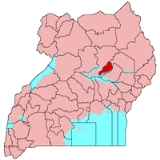
Kaberamaido is a district
in Eastern Uganda
. Like most other Ugandan districts, it is named after its 'chief town', Kaberamaido
, where the district headquarters are located.
to the north, Amuria District
to the northeast, Soroti District
to the east, Serere District
to the southeast, Buyende District
to the south, Amolatar District
to the southwest and Dokolo District
to the northwest. The District headquarters at Kaberamaido
, lie approximately 410 kilometres (254.8 mi) by road, northeast of Kampala, Uganda
's capital and largest city.
{| style="font-size:100%;"
|-
| width="100%" align="center" | Kaberamaido District Population Trends
|- valign="top"
|
{| class="wikitable sortable" style="margin-left:auto;margin-right:auto"
! style="width:2em;" |Year!! Estimated Population
|-
|2002||131,700
|-
|2003||138,600
|-
|2004||145,700
|-
|2005||153,300
|-
|2006||161,400
|-
|2007||169,700
|-
|2008||178,500
|-
|2009||187,900
|-
|2010||195,400
|-
|}
and is the main area of the Kumam
people. In 2008, the Kumam
were in the majority, totaling 99,738 (74.7%) of the population. The Iteso
were the next most populous group in the district, totaling 27,317 people (20.5%). These two ethnicities respectively, speak Kumam and Ateso languages and are of the Nilotic
family. The Langi
at 4,617 people (3.5%) are the next most populous group. The other tribal groups found in the district constitute less than 1% of the district population in individual tribal terms. These include, the Acholi, Bagwere
, Bakenyi, Baruli, Mening, Basoga, Baganda
and Alur
.
Districts of Uganda
Uganda is divided into 111 districts and one city across four administrative regions. Most districts are named after their main commercial and administrative towns....
in Eastern Uganda
Eastern Region, Uganda
Eastern Region is a region of Uganda. It is divided into the following districts:...
. Like most other Ugandan districts, it is named after its 'chief town', Kaberamaido
Kaberamaido
Kaberamaido is a town in Eastern Uganda. It is the main municipal, administrative and commercial center of Kaberamaido District and is the location of the headquarters for the district.-Location:...
, where the district headquarters are located.
Location
Kaberamaido District lies approximately between Latitudes:1.5500 to 2.3834 and Longitudes:30.0167 to 34.3000. The average coordinates of the district are:01 47N, 33 09E. The district is bordered by Alebtong DistrictAlebtong District
Alebtong District is a district in Northern Uganda. It is named after its 'chief' town, Alebtong, where the district headquarters are located.-Location:...
to the north, Amuria District
Amuria District
Amuria District is a district in Eastern Uganda. It is named after its 'chief town', Amuria, the location of the district headquarters.-Location:...
to the northeast, Soroti District
Soroti District
Soroti District is a district in Eastern Uganda. It is named after its chief municipal, administrative and commercial headquarters, Soroti, where the district headquarters are located.-Location:...
to the east, Serere District
Serere District
Serere District is a district in Eastern Uganda. It's named after its 'chief town', Serere, where the district headquarters are located.-Location:...
to the southeast, Buyende District
Buyende District
Buyende District is a district in Eastern Uganda. It is named after Buyende, the 'chief town' in the district and the location of the district headquarters.-Location:...
to the south, Amolatar District
Amolatar District
Amolatar District is a district in Northern Uganda. Like most Ugandan districts, it is named after its 'chief town', Amolatar, where the district headquarters are located.-Location:...
to the southwest and Dokolo District
Dokolo District
Dokolo District is a district in Northern Uganda. Like most Ugandan districts, it is named after its 'chief town', Dokolo, where the district headquarters are located.-Location:...
to the northwest. The District headquarters at Kaberamaido
Kaberamaido
Kaberamaido is a town in Eastern Uganda. It is the main municipal, administrative and commercial center of Kaberamaido District and is the location of the headquarters for the district.-Location:...
, lie approximately 410 kilometres (254.8 mi) by road, northeast of Kampala, Uganda
Uganda
Uganda , officially the Republic of Uganda, is a landlocked country in East Africa. Uganda is also known as the "Pearl of Africa". It is bordered on the east by Kenya, on the north by South Sudan, on the west by the Democratic Republic of the Congo, on the southwest by Rwanda, and on the south by...
's capital and largest city.
Physical measurements
The following are the district measurements:- Total Area : 1644 square kilometre
- Total Land Area : 1210 square kilometre (73.6%)
- Forest Area : 22 square kilometres (8.5 sq mi) (1.3%)
- Open Water Area : 269 square kilometre (16.4%)
- Area Under Wetlands : 143 square kilometre (8.7%)
Population
The district had a population of approximately 131,700 in 2002. It is estimated that in 2010, the population of the district was approximately 195,400. See table below:{| style="font-size:100%;"
|-
| width="100%" align="center" | Kaberamaido District Population Trends
|- valign="top"
|
{| class="wikitable sortable" style="margin-left:auto;margin-right:auto"
! style="width:2em;" |Year!! Estimated Population
|-
|2002||131,700
|-
|2003||138,600
|-
|2004||145,700
|-
|2005||153,300
|-
|2006||161,400
|-
|2007||169,700
|-
|2008||178,500
|-
|2009||187,900
|-
|2010||195,400
|-
|}
Ethnicities
Kaberamaido District is part of Teso sub-regionTeso sub-region
Teso sub-region is a region in Uganda that consists of:* Amuria District* Bukedea District* Kaberamaido District* Katakwi District* Kumi District* Ngora District* Serere District* Soroti District...
and is the main area of the Kumam
Kumam
The Kumam are a Ugandan ethnic group of about 150,000 living mainly in Kaberamaido district as well as the western areas of Teso sub-region, and the south-east of Lango sub-region....
people. In 2008, the Kumam
Kumam
The Kumam are a Ugandan ethnic group of about 150,000 living mainly in Kaberamaido district as well as the western areas of Teso sub-region, and the south-east of Lango sub-region....
were in the majority, totaling 99,738 (74.7%) of the population. The Iteso
Iteso
The Teso are an ethnic group in eastern Uganda and western Kenya. Teso refers to the traditional homeland of the Iteso, and Ateso is their language.-Uganda:...
were the next most populous group in the district, totaling 27,317 people (20.5%). These two ethnicities respectively, speak Kumam and Ateso languages and are of the Nilotic
Nilotic languages
The Nilotic languages are a group of Eastern Sudanic languages spoken across a wide area between southern Sudan and Tanzania by the Nilotic peoples, particularly associated with cattle-herding...
family. The Langi
Langi
Langi may refer to:*Ləngi, Azerbaijan*Langi people, a people of Uganda* Langi , Tongan burial structures for kings...
at 4,617 people (3.5%) are the next most populous group. The other tribal groups found in the district constitute less than 1% of the district population in individual tribal terms. These include, the Acholi, Bagwere
Bagwere
The Gwere people, or Bagwere, are a Bantu ethnic group in Uganda. The Bagwere constitute an estimated 4% of Uganda's population.-Location:...
, Bakenyi, Baruli, Mening, Basoga, Baganda
Baganda
The Ganda are an ethnic group native to Buganda, a subnational kingdom within Uganda. Traditionally comprising 52 tribes the Ganda have a rich history and culture...
and Alur
Alur
Alur may refer to:*Alur people of Uganda and the Democratic Republic of the Congo.*Alur language, the language spoken by the Alur people*Alur, Afghanistan, a town in AfghanistanAlur may also refer to several Panchayat and villages in India,...
.
External links
See also
- KaberamaidoKaberamaidoKaberamaido is a town in Eastern Uganda. It is the main municipal, administrative and commercial center of Kaberamaido District and is the location of the headquarters for the district.-Location:...
- Teso sub-regionTeso sub-regionTeso sub-region is a region in Uganda that consists of:* Amuria District* Bukedea District* Kaberamaido District* Katakwi District* Kumi District* Ngora District* Serere District* Soroti District...
- Eastern Region, UgandaEastern Region, UgandaEastern Region is a region of Uganda. It is divided into the following districts:...
- Districts of UgandaDistricts of UgandaUganda is divided into 111 districts and one city across four administrative regions. Most districts are named after their main commercial and administrative towns....