
Kauai
Encyclopedia
Kauai or Kauai
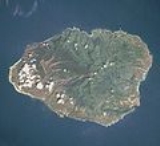
known as Tauai in the ancient Kaua'i dialect, is geologically the oldest of the main Hawaiian Islands
. With an area of 562.3 square miles (1,456.4 km²), it is the fourth largest of the main islands in the Hawaiian archipelago, and the 21st largest island in the United States. Known also as the "Garden Isle", Kauai lies 105 miles (169 km) across the Kauai Channel
, northwest of Oahu
. This island is the site of Waimea Canyon State Park
.
The United States Census Bureau
defines Kauai as Census Tracts
401 through 409 of Kauai County, Hawaii
, which is all of the county except for the islands of Kaʻula, Lehua
, and Niihau
. The 2000 census
population of Kauai (the island) was 58,303.
— the Polynesia
n navigator attributed with discovery of the Hawaiian Islands. The story relates how he named the island of Kauai after a favorite son; therefore a possible translation of Kauai is "place around the neck", meaning how a father would carry a favorite child. Another possible translation is "food season."
Kauai was known for its distinct dialect of the Hawaiian language
before it went extinct there. Whereas the standard language today is based on the dialect of Hawaii island
, which has the sound [k] at the beginning of words, the Kauai dialect was known for pronouncing this as [t]. In effect, Kauai dialect retained the old pan-Polynesian /t/, while 'standard' Hawaii dialect has innovated and changed it to the [k]. Therefore, the native name for Kauai was Tauai, and the major settlement of Kapaa would have been called Tapaa.
, the island having been formed by the passage of the Pacific plate
over the Hawaii hotspot
. At approximately six million years old, it is the oldest of the main islands. The highest peak on this mountainous island is Kawaikini
at 5243 feet (1,598 m).
The second highest peak is Mount Waialeale
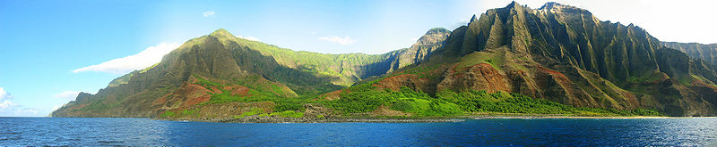
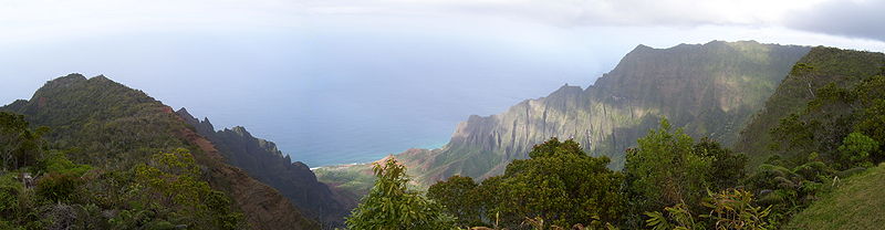
near the center of the island, 5148 feet (1,569 m) above sea level. One of the wettest spots on earth, with an annual average rainfall of 460 inches (1,168.4 cm), is located on the east side of Mount Waialeale. The high annual rainfall has eroded deep valleys in the central mountains, carving out canyons with many scenic waterfalls. On the west side of the island, Waimea
town is located at the mouth of the Waimea River, whose flow formed Waimea Canyon, one of the world's most scenic canyons, and which is part of Waimea Canyon State Park
. At 3000 feet (914 m) deep, Waimea Canyon is often referred to as "The Grand Canyon of the Pacific". The Na Pali Coast is a center for recreation in a wild setting, including kayaking past the beaches, or hiking on the trail along the coastal cliffs.
arrived at Waimea Bay, the first European known to have reached the Hawaiian islands, which he named after his patron the Earl of Sandwich.
During the reign of King Kamehameha
, the islands of Kauai and Niihau were the last Hawaiian Islands to join his Kingdom of Hawaii
. Their ruler, Kaumualii
, resisted Kamehameha for years. King Kamehameha twice prepared a huge armada of ships and canoes to take the islands by force, and twice failed; once due to a storm, and once due to an epidemic. In the face of the threat of a further invasion, however, Kaumualii decided to join the kingdom without bloodshed, and became Kamehameha's vassal in 1810, ceding the island to the Kingdom of Hawaii upon his death in 1824.
In 1815-17, Kaumualii led secret negotiations with representatives of the Russian-American Company
in an attempt to gain Russia's military support against Kamehameha; however, the negotiations folded and the Russians were forced to abandon all of their presence in Kauai, including Fort Elizabeth
, after it was revealed that they did not have the support of Tsar Alexander I
.
In 1835 Old Koloa Town opened a sugar mill. Missionaries also came in the 19th century.
As of mid-2004, the median price of a single-family home was $528,000, a 40% increase over 2003. As of 2003, Kauai's percentage of home ownership, 48%, was significantly lower than the State's 64%, and vacation homes were a far larger part of the housing stock than the State-wide percentage (Kauai 15%, State 5%).
Land in Kauaʻi is very fertile and is home to many varieties of fruits and crops. Guava
, coffee
, sugarcane
, mango
, banana
, papaya
, avocado
, star fruit
, kava
and pineapple
are all cultivated.
is observed on Kaua'i year-round. During DST, for example, the time on Kaua'i is three hours behind the West Coast
of the United States and six hours behind the East Coast
.
The city of Līhue, on the island's southeast coast, is the seat of Kauai County
and the second largest city on the island. Kapaa, on the "Coconut Coast" (site of an old coconut plantation) about 6 miles (9.7 km) north of Līhue, has a population of nearly 10,000, or about 50% greater than Līhue. Waimea
, once the capital of Kauai on the island's southwest side, was the first place in Hawaii visited by British explorer Captain James Cook
in 1778.
Kauai is home to thousands of wild chickens, who have few natural predators. Kauai's chickens originated from the original Polynesia
n settlers, who brought them as a food source.
Kauai is home to the U.S. Navy's "Barking Sands" Pacific Missile Range Facility
, on the sunny and dry western shore.
HF
("shortwave
") radio station WWVH
, sister station to WWV and WWVB
in Ft. Collins, Colorado, is located on the west coast of Kauai about 5 km south of Barking Sands.
WWVH, WWV and WWVB
are operated by the US National Institute of Standards and Technology
, broadcasting standard time and frequency information to the public.
The Kauai Heritage Center of Hawaiian Culture and the Arts was founded in 1998. Their mission is to nurture a greater sense of appreciation and respect for the Hawaiian culture. They offer classes in Hawaiian language, hula, lei and cordage making, the lunar calendar and chanting. Plus trips to cultural sites.

 Cities and towns on Kauai range in population from the roughly 9,500 people in Kapaa to tiny hamlets. The list below lists the larger or more notable of those from the northernmost end of Hawaii Route 560
to the western terminus of Hawaii Route 50
.
, Kahului/Maui
, the United States mainland and Vancouver, Canada.
Other major highways that link other parts of the Island to the main highways of Kauaʻi are:

, Lilo & Stitch 2: Stitch Has a Glitch
, Stitch! The Movie
, and Lilo & Stitch: The Series
. Scenes from South Pacific were filmed in the vicinity of Hanalei. Waimea Canyon was used in the filming of the 1993 film
Jurassic Park
. Parts of the island were also used for the opening scenes of Indiana Jones' Raiders of the Lost Ark
. Other movies filmed here include Six Days Seven Nights
, the 2005 remake of King Kong
and John Ford's 1963 film Donovan's Reef
. Recent films include Tropic Thunder
and a biopic of Bethany Hamilton
entitled Soul Surfer
. A scene in the opening credits of popular TV show M*A*S*H was filmed in Kauai (helicopter flying over mountain top). Some scenes from Just Go with It
and Pirates of the Caribbean: On Stranger Tides
were also filmed in Kauai.
Parts of the 2002 film Dragonfly were filmed there (although the people and the land were presented as South American) and the producers hired extras (at least three with speaking parts) from the ancient Hawaiian native population, which seeks to preserve its cultural heritage, including the pre-USA name of these two islands, Atooi or Tauai.
Major parts of the 1966 Elvis Presley film Paradise, Hawaiian Style
were filmed at various locations on Kauai. One of the most famous was the Coco Palms resort
. During Hurricane Iniki
, the Coco Palms was decimated and never rebuilt, but the film showcases the resort at its peak.
known as Tauai in the ancient Kaua'i dialect, is geologically the oldest of the main Hawaiian Islands
Hawaiian Islands
The Hawaiian Islands are an archipelago of eight major islands, several atolls, numerous smaller islets, and undersea seamounts in the North Pacific Ocean, extending some 1,500 miles from the island of Hawaii in the south to northernmost Kure Atoll...
. With an area of 562.3 square miles (1,456.4 km²), it is the fourth largest of the main islands in the Hawaiian archipelago, and the 21st largest island in the United States. Known also as the "Garden Isle", Kauai lies 105 miles (169 km) across the Kauai Channel
Hawaiian islands channels
In an archipelago like the Hawaiian Islands the water between islands is typically called a channel or passage. Described here are the channels between the islands of Hawaii, arranged from southeast to northwest.- Alenuihāhā Channel :...
, northwest of Oahu
Oahu
Oahu or Oahu , known as "The Gathering Place", is the third largest of the Hawaiian Islands and most populous of the islands in the U.S. state of Hawaii. The state capital Honolulu is located on the southeast coast...
. This island is the site of Waimea Canyon State Park
Waimea Canyon State Park
Waimea Canyon, also known as the Grand Canyon of the Pacific, is a large canyon, approximately ten miles long and up to 3,000 feet deep, located on the western side of Kauai in the Hawaiian Islands. Waimea is Hawaiian for "reddish water," a reference to the erosion of the canyon's red soil...
.
The United States Census Bureau
United States Census Bureau
The United States Census Bureau is the government agency that is responsible for the United States Census. It also gathers other national demographic and economic data...
defines Kauai as Census Tracts
Census tract
A census tract, census area, or census district is a geographic region defined for the purpose of taking a census. Usually these coincide with the limits of cities, towns or other administrative areas and several tracts commonly exist within a county...
401 through 409 of Kauai County, Hawaii
Kauai County, Hawaii
Kauai County is a county located in the U.S. state of Hawaii. It consists of the islands of Kauai, Niihau, Lehua, and Kaula, in the state of Hawaii. As of 2000 Census the population was 58,463...
, which is all of the county except for the islands of Kaʻula, Lehua
Lehua
Lehua is a small, crescent-shaped island in the Hawaiian islands, only north of Niihau, due west of Kauai. The uninhabited, barren island is a tuff cone which is part of the extinct Niihau volcano....
, and Niihau
Niihau
Niihau or Niihau is the seventh largest of the inhabited Hawaiian Islands in the U.S. state of Hawaii, having an area of . Niihau lies southwest of Kauai across the Kaulakahi Channel. Several intermittent playa lakes provide wetland habitats for the Hawaiian Coot, the Black-winged Stilt, and the...
. The 2000 census
United States Census, 2000
The Twenty-second United States Census, known as Census 2000 and conducted by the Census Bureau, determined the resident population of the United States on April 1, 2000, to be 281,421,906, an increase of 13.2% over the 248,709,873 persons enumerated during the 1990 Census...
population of Kauai (the island) was 58,303.
Etymology and language
Native Hawaiian tradition indicates the name's origin in the legend of HawaiiloaHawaiiloa
Hawaiiloa is the hero of an ancient Hawaiian legend about the settling of the Hawaiian Islands. After having accidentally stumbled upon the islands, he returned to his homeland which he called Ka āina kai melemele a Kane, "the land of the yellow sea of Kane". He then organized a colonizing...
— the Polynesia
Polynesia
Polynesia is a subregion of Oceania, made up of over 1,000 islands scattered over the central and southern Pacific Ocean. The indigenous people who inhabit the islands of Polynesia are termed Polynesians and they share many similar traits including language, culture and beliefs...
n navigator attributed with discovery of the Hawaiian Islands. The story relates how he named the island of Kauai after a favorite son; therefore a possible translation of Kauai is "place around the neck", meaning how a father would carry a favorite child. Another possible translation is "food season."
Kauai was known for its distinct dialect of the Hawaiian language
Hawaiian language
The Hawaiian language is a Polynesian language that takes its name from Hawaii, the largest island in the tropical North Pacific archipelago where it developed. Hawaiian, along with English, is an official language of the state of Hawaii...
before it went extinct there. Whereas the standard language today is based on the dialect of Hawaii island
Hawaii (island)
The Island of Hawaii, also called the Big Island or Hawaii Island , is a volcanic island in the North Pacific Ocean...
, which has the sound [k] at the beginning of words, the Kauai dialect was known for pronouncing this as [t]. In effect, Kauai dialect retained the old pan-Polynesian /t/, while 'standard' Hawaii dialect has innovated and changed it to the [k]. Therefore, the native name for Kauai was Tauai, and the major settlement of Kapaa would have been called Tapaa.
Geography
Kauai's origins are volcanicVolcano
2. Bedrock3. Conduit 4. Base5. Sill6. Dike7. Layers of ash emitted by the volcano8. Flank| 9. Layers of lava emitted by the volcano10. Throat11. Parasitic cone12. Lava flow13. Vent14. Crater15...
, the island having been formed by the passage of the Pacific plate
Pacific Plate
The Pacific Plate is an oceanic tectonic plate that lies beneath the Pacific Ocean. At 103 million square kilometres, it is the largest tectonic plate....
over the Hawaii hotspot
Hawaii hotspot
The Hawaii hotspot is the volcanic hotspot that created the Hawaiian Islands in the central Pacific Ocean, and is one of Earth's best-known and most heavily-studied hotspots....
. At approximately six million years old, it is the oldest of the main islands. The highest peak on this mountainous island is Kawaikini
Kawaikini
Kawaikini is the highest point on the Hawaiian Island of Kauai and in Kauai County and measures in elevation. It is the summit of the island's inactive central shield volcano, Mount Waialeale...
at 5243 feet (1,598 m).
The second highest peak is Mount Waialeale
Mount Waialeale
Mount Waialeale at an elevation of , is a shield volcano and the second highest point on the island of Kauai in the Hawaiian Islands. Averaging more than of rain a year since 1912, with a record in 1982, its summit is one of the rainiest spots on earth....
near the center of the island, 5148 feet (1,569 m) above sea level. One of the wettest spots on earth, with an annual average rainfall of 460 inches (1,168.4 cm), is located on the east side of Mount Waialeale. The high annual rainfall has eroded deep valleys in the central mountains, carving out canyons with many scenic waterfalls. On the west side of the island, Waimea
Waimea, Kauai County, Hawaii
Waimea is a census-designated place in Kauai County, Hawaii, United States. The population was 1,787 at the 2000 census...
town is located at the mouth of the Waimea River, whose flow formed Waimea Canyon, one of the world's most scenic canyons, and which is part of Waimea Canyon State Park
Waimea Canyon State Park
Waimea Canyon, also known as the Grand Canyon of the Pacific, is a large canyon, approximately ten miles long and up to 3,000 feet deep, located on the western side of Kauai in the Hawaiian Islands. Waimea is Hawaiian for "reddish water," a reference to the erosion of the canyon's red soil...
. At 3000 feet (914 m) deep, Waimea Canyon is often referred to as "The Grand Canyon of the Pacific". The Na Pali Coast is a center for recreation in a wild setting, including kayaking past the beaches, or hiking on the trail along the coastal cliffs.
History
In 1778, captain James CookJames Cook
Captain James Cook, FRS, RN was a British explorer, navigator and cartographer who ultimately rose to the rank of captain in the Royal Navy...
arrived at Waimea Bay, the first European known to have reached the Hawaiian islands, which he named after his patron the Earl of Sandwich.
During the reign of King Kamehameha
Kamehameha I
Kamehameha I , also known as Kamehameha the Great, conquered the Hawaiian Islands and formally established the Kingdom of Hawaii in 1810. By developing alliances with the major Pacific colonial powers, Kamehameha preserved Hawaii's independence under his rule...
, the islands of Kauai and Niihau were the last Hawaiian Islands to join his Kingdom of Hawaii
Kingdom of Hawaii
The Kingdom of Hawaii was established during the years 1795 to 1810 with the subjugation of the smaller independent chiefdoms of Oahu, Maui, Molokai, Lānai, Kauai and Niihau by the chiefdom of Hawaii into one unified government...
. Their ruler, Kaumualii
Kaumualii
Kaumualii was the last independent Alii Aimoku of Kauai and Niihau before becoming a vassal of Kamehameha I of the unified Kingdom of Hawaii in 1810...
, resisted Kamehameha for years. King Kamehameha twice prepared a huge armada of ships and canoes to take the islands by force, and twice failed; once due to a storm, and once due to an epidemic. In the face of the threat of a further invasion, however, Kaumualii decided to join the kingdom without bloodshed, and became Kamehameha's vassal in 1810, ceding the island to the Kingdom of Hawaii upon his death in 1824.
In 1815-17, Kaumualii led secret negotiations with representatives of the Russian-American Company
Russian-American Company
The Russian-American Company was a state-sponsored chartered company formed largely on the basis of the so-called Shelekhov-Golikov Company of Grigory Shelekhov and Ivan Larionovich Golikov The Russian-American Company (officially: Under His Imperial Majesty's Highest Protection (patronage)...
in an attempt to gain Russia's military support against Kamehameha; however, the negotiations folded and the Russians were forced to abandon all of their presence in Kauai, including Fort Elizabeth
Russian Fort Elizabeth
Russian Fort Elizabeth is a fort on the island of Kauai in Hawaii. It was the last remaining Russian fort on the Hawaiian islands, built in the early 19th century by the Russian-American Company as the result of an alliance with High Chief Kaumualii to gain influence in Hawaii...
, after it was revealed that they did not have the support of Tsar Alexander I
Alexander I of Russia
Alexander I of Russia , served as Emperor of Russia from 23 March 1801 to 1 December 1825 and the first Russian King of Poland from 1815 to 1825. He was also the first Russian Grand Duke of Finland and Lithuania....
.
In 1835 Old Koloa Town opened a sugar mill. Missionaries also came in the 19th century.
Economy
Tourism is Kauai's largest industry. In 2007, 1,271,000 visitors came to Kauai. The two largest groups were from the United States (84% of all visitors) and Japan (3%). As of 2003, there were a total of approximately 27,000 jobs on Kauai, of which the largest sector was accommodation/food services (26%, 6,800 jobs) followed by government (15%) and retail (14.5%), with agriculture accounting for just 2.9% (780 jobs) and educational services providing just 0.7% (183 jobs). In terms of income, the various sectors that constitute the visitors industry accounted for one third of Kauai's income. On the other hand, employment is dominated by small businesses, with 87% of all nonfarm businesses having fewer than 20 employees. As of 2003, Kauai's unemployment rate was 3.9%, compared to 3.0% for the entire state and 5.7% for the United States as a whole; and, Kauai's poverty rate was 10.5%, compared to the State's 10.7%.As of mid-2004, the median price of a single-family home was $528,000, a 40% increase over 2003. As of 2003, Kauai's percentage of home ownership, 48%, was significantly lower than the State's 64%, and vacation homes were a far larger part of the housing stock than the State-wide percentage (Kauai 15%, State 5%).
Agriculture
In the past, sugar plantations were Kauai's most important industry. In 1835 the first sugar plantation was founded on Kauai and for the next century the industry would dominate the economy of Hawaii. The minimum wage law (Federal Labor Standards Act) and protected the rights of workers to unionize led to the closure of most of the sugar plantation. Now most of that land is now used for ranching. Kauai's sole remaining sugar operation, the 118-year-old Gay & Robinson Plantation plans to transform itself into a manufacturer of sugar-cane ethanol.Land in Kauaʻi is very fertile and is home to many varieties of fruits and crops. Guava
Guava
Guavas are plants in the myrtle family genus Psidium , which contains about 100 species of tropical shrubs and small trees. They are native to Mexico, Central America, and northern South America...
, coffee
Coffee
Coffee is a brewed beverage with a dark,init brooo acidic flavor prepared from the roasted seeds of the coffee plant, colloquially called coffee beans. The beans are found in coffee cherries, which grow on trees cultivated in over 70 countries, primarily in equatorial Latin America, Southeast Asia,...
, sugarcane
Sugarcane
Sugarcane refers to any of six to 37 species of tall perennial grasses of the genus Saccharum . Native to the warm temperate to tropical regions of South Asia, they have stout, jointed, fibrous stalks that are rich in sugar, and measure two to six metres tall...
, mango
Mango
The mango is a fleshy stone fruit belonging to the genus Mangifera, consisting of numerous tropical fruiting trees in the flowering plant family Anacardiaceae. The mango is native to India from where it spread all over the world. It is also the most cultivated fruit of the tropical world. While...
, banana
Banana
Banana is the common name for herbaceous plants of the genus Musa and for the fruit they produce. Bananas come in a variety of sizes and colors when ripe, including yellow, purple, and red....
, papaya
Papaya
The papaya , papaw, or pawpaw is the fruit of the plant Carica papaya, the sole species in the genus Carica of the plant family Caricaceae...
, avocado
Avocado
The avocado is a tree native to Central Mexico, classified in the flowering plant family Lauraceae along with cinnamon, camphor and bay laurel...
, star fruit
Carambola
Carambola, also known as starfruit, is the fruit of Averrhoa carambola, a species of tree native to the Philippines, Indonesia, Malaysia, India, Bangladesh and Sri Lanka. The fruit is a popular food throughout Southeast Asia, the South Pacific and parts of East Asia...
, kava
Kava
Kava or kava-kava is a crop of the western Pacific....
and pineapple
Pineapple
Pineapple is the common name for a tropical plant and its edible fruit, which is actually a multiple fruit consisting of coalesced berries. It was given the name pineapple due to its resemblance to a pine cone. The pineapple is by far the most economically important plant in the Bromeliaceae...
are all cultivated.
Island facts
Hawaii Standard TimeHawaii-Aleutian time zone
The Hawaii-Aleutian Time Zone observes Hawaii-Aleutian Standard Time , by subtracting ten hours from Coordinated Universal Time . The clock time in this zone is based on the mean solar time of the 150th meridian west of the Greenwich Observatory....
is observed on Kaua'i year-round. During DST, for example, the time on Kaua'i is three hours behind the West Coast
West Coast of the United States
West Coast or Pacific Coast are terms for the westernmost coastal states of the United States. The term most often refers to the states of California, Oregon, and Washington. Although not part of the contiguous United States, Alaska and Hawaii do border the Pacific Ocean but can't be included in...
of the United States and six hours behind the East Coast
East Coast of the United States
The East Coast of the United States, also known as the Eastern Seaboard, refers to the easternmost coastal states in the United States, which touch the Atlantic Ocean and stretch up to Canada. The term includes the U.S...
.
The city of Līhue, on the island's southeast coast, is the seat of Kauai County
Kauai County, Hawaii
Kauai County is a county located in the U.S. state of Hawaii. It consists of the islands of Kauai, Niihau, Lehua, and Kaula, in the state of Hawaii. As of 2000 Census the population was 58,463...
and the second largest city on the island. Kapaa, on the "Coconut Coast" (site of an old coconut plantation) about 6 miles (9.7 km) north of Līhue, has a population of nearly 10,000, or about 50% greater than Līhue. Waimea
Waimea, Kauai County, Hawaii
Waimea is a census-designated place in Kauai County, Hawaii, United States. The population was 1,787 at the 2000 census...
, once the capital of Kauai on the island's southwest side, was the first place in Hawaii visited by British explorer Captain James Cook
James Cook
Captain James Cook, FRS, RN was a British explorer, navigator and cartographer who ultimately rose to the rank of captain in the Royal Navy...
in 1778.
Kauai is home to thousands of wild chickens, who have few natural predators. Kauai's chickens originated from the original Polynesia
Polynesia
Polynesia is a subregion of Oceania, made up of over 1,000 islands scattered over the central and southern Pacific Ocean. The indigenous people who inhabit the islands of Polynesia are termed Polynesians and they share many similar traits including language, culture and beliefs...
n settlers, who brought them as a food source.
Kauai is home to the U.S. Navy's "Barking Sands" Pacific Missile Range Facility
Pacific Missile Range Facility
The Pacific Missile Range Facility, Barking Sands is a U.S. Naval facility and airport located five nautical miles northwest of the central business district of Kekaha, in Kauai County, Hawaii, United States....
, on the sunny and dry western shore.
HF
High frequency
High frequency radio frequencies are between 3 and 30 MHz. Also known as the decameter band or decameter wave as the wavelengths range from one to ten decameters . Frequencies immediately below HF are denoted Medium-frequency , and the next higher frequencies are known as Very high frequency...
("shortwave
Shortwave
Shortwave radio refers to the upper MF and all of the HF portion of the radio spectrum, between 1,800–30,000 kHz. Shortwave radio received its name because the wavelengths in this band are shorter than 200 m which marked the original upper limit of the medium frequency band first used...
") radio station WWVH
WWVH
WWVH is the callsign of the U.S. National Institute of Standards and Technology's shortwave radio time signal station in Kekaha, on the island of Kauai in the state of Hawaii....
, sister station to WWV and WWVB
WWVB
WWVB is a NIST time signal radio station near Fort Collins, Colorado, co-located with WWV. WWVB is the station that radio-controlled clocks in most of North America use to synchronize themselves. The signal transmitted from WWVB is a continuous 60 kHz carrier wave, derived from a set of atomic...
in Ft. Collins, Colorado, is located on the west coast of Kauai about 5 km south of Barking Sands.
WWVH, WWV and WWVB
WWVB
WWVB is a NIST time signal radio station near Fort Collins, Colorado, co-located with WWV. WWVB is the station that radio-controlled clocks in most of North America use to synchronize themselves. The signal transmitted from WWVB is a continuous 60 kHz carrier wave, derived from a set of atomic...
are operated by the US National Institute of Standards and Technology
National Institute of Standards and Technology
The National Institute of Standards and Technology , known between 1901 and 1988 as the National Bureau of Standards , is a measurement standards laboratory, otherwise known as a National Metrological Institute , which is a non-regulatory agency of the United States Department of Commerce...
, broadcasting standard time and frequency information to the public.
The Kauai Heritage Center of Hawaiian Culture and the Arts was founded in 1998. Their mission is to nurture a greater sense of appreciation and respect for the Hawaiian culture. They offer classes in Hawaiian language, hula, lei and cordage making, the lunar calendar and chanting. Plus trips to cultural sites.
Important towns and cities
Hawaii Route 560
Route 560 or Kaua'i Belt Road-North Shore section, is a ten-mile scenic road on the northern shore of the island of Kauai in Hawaii. The entire belt road is signed as the Kuhio Highway and Hawaii Route 56 was once signed on this route before it was downgraded to become Hawaii Route 560...
to the western terminus of Hawaii Route 50
Hawaii Route 50
Route 50 is a road that stretches from Route 56 at the junction of Rice Street in Lihue to a point approximately 1/5 mile north of the northernmost entrance of the Pacific Missile Range Facility on the western shore of Kauai. It is the longest numbered road on the island of Kauai is named...
.
- Hāena
- WainihaWainiha, Hawaii-Geography:This land section is on the northern coast of Kauai and includes a bay and canal. The terrain is varied and also includes a cliff , river, and valley. Wainiha is 25.49 square miles.-Community demographics:...
- HanaleiHanalei, HawaiiHanalei is a census-designated place in Kauai County, Hawaii, United States. The population was 478 at the 2000 census. Hanalei means "lei making" in Hawaiian...
- PrincevillePrinceville, HawaiiPrinceville is a census-designated place on the north shore of the island of Kauai in Kauai County, Hawaii, United States. The population was 1,698 at the 2000 census.-Geography:Princeville is located at ....
- KalihiwaiKalihiwai, HawaiiKalihiwai is a census-designated place in Kauai County, Hawaii, United States...
- KilaueaKilauea, HawaiiKīlauea, on the Island of Kauai, shares the name of the active volcano, Mt. Kilauea. The name literally translates to "spewing" or '"much spreading" in Hawaiian. Kilauea, the town, is a census-designated place in Kauai County, Hawaii, United States....
- AnaholaAnahola, HawaiiAnahola is a census-designated place in Kauai County, Hawaii, United States. The population was 1,932 at the 2000 census.- History :...
- Kapaa
- WailuaWailua, HawaiiWailuā is a census-designated place in Kauai County, Hawaii, United States. The population was 2,083 at the 2000 census.-Geography:...
- HanamāuluHanamaulu, HawaiiHanamāulu is a census-designated place in Kauai County, Hawaii, United States...
- Līhue
- PoipūPoipu, HawaiiPoipū is a census-designated place in Kauai County on the southern side of the island of Kauai in the U.S. state of Hawaii. The population was 1,075 at the 2000 census...
- KōloaKoloa, HawaiiKōloa is a census-designated place in Kauai County, Hawaii, United States. The population was 1,942 at the 2000 census. Kōloa is often incorrectly translated as native duck, which is the correct translation for the similar-looking koloa . Kōloa has no known translation...
- LāwaiLawai, HawaiiLāwai is a census-designated place in Kauai County in the U.S. state of Hawaii. The population was 1,984 at the 2000 census.-Geography:Lāwai is located at ....
- KalāheoKalaheo, HawaiiKalāheo is a census-designated place in Kauai County, island of Kauai, Hawaii, United States...
- EleeleEleele, HawaiiEleele is a census-designated place in Kauai County, Hawaii, United States, with the zip-code of 96705...
- HanapēpeHanapepe, HawaiiHanapepe is a census-designated place in Kauai County, Hawaii, United States...
- KaumakaniKaumakani, HawaiiKaumakani is a census-designated place in Kauai County, Hawaii, United States. The population was 607 at the 2000 census.-History:...
- WaimeaWaimea, Kauai County, HawaiiWaimea is a census-designated place in Kauai County, Hawaii, United States. The population was 1,787 at the 2000 census...
- KekahaKekaha, HawaiiKekaha is a census-designated place in Kauai County, Hawaii, United States. The population was 3,175 at the 2000 census.-History:...
Air
Located on the eastern end of the island, Lihue Airport is the aviation gateway to Kauai. Lihuʻe Airport has direct routes to HonoluluHonolulu International Airport
Honolulu International Airport is the principal aviation gateway of the City & County of Honolulu and the State of Hawaii and is identified as one of the busiest airports in the United States, with traffic now exceeding 21 million passengers a year and rising.It is located in the Honolulu...
, Kahului/Maui
Kahului Airport
Kahului Airport is a regional airport in the state of Hawai'i, located east of the Kahului CDP in Maui County on the island of Maui near Haleakala. Most flights into OGG originate from Honolulu International Airport; the Honolulu–Kahului corridor is one of the busiest air routes in the US,...
, the United States mainland and Vancouver, Canada.
Highways
Several state highways serve Kauaʻi County:- Hawaii Route 50Hawaii Route 50Route 50 is a road that stretches from Route 56 at the junction of Rice Street in Lihue to a point approximately 1/5 mile north of the northernmost entrance of the Pacific Missile Range Facility on the western shore of Kauai. It is the longest numbered road on the island of Kauai is named...
, also known as Kaumualiʻi Highway, is a thirty-three mile road that stretches from Hawaii Route 56Hawaii Route 56Route 56, also known as Kuhio Highway, is the main highway on the north and east shore of Kauaii island.-Route description :Route 56 runs , stretching from Hawaii Route 50 at the junction of Rice Street in Lihue, Hawaii to the junction of Hawaii Route 560 in Princeville on the island of Kauaii...
at the junction of Rice Street in Lihuʻe to a point approximately 1/5 mile north of the northernmost entrance of the Pacific Missile Range FacilityPacific Missile Range FacilityThe Pacific Missile Range Facility, Barking Sands is a U.S. Naval facility and airport located five nautical miles northwest of the central business district of Kekaha, in Kauai County, Hawaii, United States....
on the far western shore. - Hawaii Route 58Hawaii Route 58Route 58 is a two mile road that stretches from Route 50 in Lihue to the junction of Wapaa Road with Hawaii 51 near Nawiliwili Harbor on Kauai island.- Route description :...
stretches two miles (3 km) from Route 50 in Lihuʻe to the junction of Wapaa Road with Hawaii 51 near Nawiliwili Harbor on Kauai. - Hawaii Route 56Hawaii Route 56Route 56, also known as Kuhio Highway, is the main highway on the north and east shore of Kauaii island.-Route description :Route 56 runs , stretching from Hawaii Route 50 at the junction of Rice Street in Lihue, Hawaii to the junction of Hawaii Route 560 in Princeville on the island of Kauaii...
, also known as Kuhio Highway, runs twenty-eight miles from Hawaii Route 50Hawaii Route 50Route 50 is a road that stretches from Route 56 at the junction of Rice Street in Lihue to a point approximately 1/5 mile north of the northernmost entrance of the Pacific Missile Range Facility on the western shore of Kauai. It is the longest numbered road on the island of Kauai is named...
at the junction of Rice Street in Lihuʻe to the junction of Hawaii Route 560 in Princeville. - Hawaii Route 560Hawaii Route 560Route 560 or Kaua'i Belt Road-North Shore section, is a ten-mile scenic road on the northern shore of the island of Kauai in Hawaii. The entire belt road is signed as the Kuhio Highway and Hawaii Route 56 was once signed on this route before it was downgraded to become Hawaii Route 560...
passes ten miles (16 km) from the junction of Route 56 in Princeville and dead ends at Keʻe Beach in Haena State Park.
Other major highways that link other parts of the Island to the main highways of Kauaʻi are:
- Hawaii Route 55 covers 7.6 miles (12.2 km) from the junction of Route 50 in Kekaha to meet with Hawaii Route 550Hawaii Route 550Route 550 is a fourteen mile road stretching from Route 50 in Waimea to Kōkeʻe State Park on the island of Kauai.-Route description:...
south of Kokeʻe State Park in the Waimea Canyon. - Hawaii Route 550Hawaii Route 550Route 550 is a fourteen mile road stretching from Route 50 in Waimea to Kōkeʻe State Park on the island of Kauai.-Route description:...
spans 15 miles (24.1 km) from Route 50Hawaii Route 50Route 50 is a road that stretches from Route 56 at the junction of Rice Street in Lihue to a point approximately 1/5 mile north of the northernmost entrance of the Pacific Missile Range Facility on the western shore of Kauai. It is the longest numbered road on the island of Kauai is named...
in WaimeaWaimea, Kauai County, HawaiiWaimea is a census-designated place in Kauai County, Hawaii, United States. The population was 1,787 at the 2000 census...
to Kōkeʻe State ParkKoke'e State ParkKōkee State Park is located in northwestern Kauai in the Hawaiian Islands. It includes a museum at the marker on State Road 550, which focuses on the weather, vegetation, and bird life; a lodge which serves food and sells gifts; cabins for rent; and hiking trails...
. - Hawaii Route 540Hawaii Route 540Route 540 is a four mile road that stretches from Route 50 in Kalaheo to Route 50 in Eleele on Kauai. The road is mainly an alternative to Route 50 and for the first mile, the Pacific Ocean is in view then the road takes a sharp turn towards, Kalahoe. Numerous agriculture fields surround the road....
goes four miles (6 km) from Route 50 in Kalaheo to Route 50 in Eleʻele. The road is mainly an access to residential areas and Kauai Coffee. - Hawaii Route 530, also called Kōloa Road, stretches 3.4 miles (5.5 km) from Route 50 between Kalaheo and Lawai to Route 520 in Koloa. The road is mainly an alternative to Route 520 for travel from the west side to Poʻipū.
- Hawaii Route 520Hawaii Route 520Route 520 is the road which connects Kōloa and Poipū to Hawaii Route 50, the principal highway of the southern part of Kauai island in the state of Hawaii...
runs five miles (8 km) from the "Tunnel of Trees" at Route 50 to Poʻipū on the south shore. - Hawaii Route 570Hawaii Route 570Route 570 is a one mile road that stretches from Route 56 in Lihue to Lihue Airport on the island of Kauai. Before of the construction of Route 51 in the 1980s, the road provided primary access to Lihue Airport with the north and eastern shores of the The Garden Isle.- Route description...
covers one mile (1.6 km) from Route 56 in Lihuʻe to Lihuʻe Airport. - Hawaii Route 580Hawaii Route 580Route 580 is a five mile road that stretches from Route 56 in Wailua to where the road is no longer serviced by Hawaii Department of Transportation just south of the Wailua Reservoir on the island of Kauai.-Background:...
spans five miles (8 km) from Route 56 in Wailua to where the road is no longer serviced just south of the Wailua Reservoir. - Hawaii Route 581 passes five miles (8 km) from Route 580 in the Wailua Homesteads to a roundabout just west of Kapaʻa Town.
- Hawaii Route 583, also known as Maalo Road, stretches 3.9 miles (6.3 km) from Route 56 just north of Lihuʻe to dead-end at Wailua Falls Overlook in the interior.
Mass transit
The Kauai Bus is the public transportation service of the County of Kauai. It is operated by Roberts Hawaii.Places of interest
- Alakai Wilderness AreaAlakai Wilderness AreaThe Alakai Wilderness Preserve, popularly known as Alakai Swamp, is a montane wet forest on the Hawaiian island of Kauai. Although the preserve is home to alpine bogs, it is not a true swamp. It is located on a plateau near Mount Waialeale, one of the wettest spots on Earth.The Alakai Swamp...
- Allerton GardenAllerton GardenAllerton Garden , also known as Lāwai-kai, is a botanical garden, originally created by Robert Allerton and John Gregg Allerton, located on the south shore of Kauai, Hawaii. The garden covers an area and is situated beside the Lāwai Bay, in a valley transected by the Lāwai Stream...
- Bell stoneBell stoneThe bellstone is a pillar located in Kauai County, Hawaii near 'Opaeka'a Falls. It is so named because, when struck sharply, a note would resonate over a large area of Wailua Valley, warning of danger. Royal births were announced this way....
- Camp Naue YMCACamp Naue YMCACamp Naue YMCA is a 12-acre beachfront campground on the north shore of Kauai, Hawaii. It contains five bunkhouses , bathrooms, showers, a pavilion, a kitchen and a dining hall. It is used by visiting campers as well as local youth groups. The campground is located directly on Haena Beach...
- Fern GrottoFern GrottoFern Grotto is a fern covered, lava rock grotto located on the Wailua River on the eastern side of Kauai in the Hawaiian archipelago. It forms a natural amphitheater which greatly increases the acoustics of the many bands that are hired to perform live music, which has traditional themes...
- Hanalei BayHanalei BayHanalei Bay is the largest bay on the north shore of Kauai island in Hawaii. The town of Hanalei is at the mid-point of the bay.Hanalei Bay consists of nearly two miles of beach, surrounded by mountains. In the summer, the bay offers excellent mooring for sailboats, stand up paddle boarding and...
- Honopo arch
- Iraivan templeIraivan templeThe San Marga Iraivan Temple is a white granite stone Hindu temple sculpted in India and currently under construction on the Hawaiian island of Kauai. The temple is dedicated to the Hindu deity Shiva. "Iraivan" means "He who is worshipped," and is one of the oldest words for God in the Tamil...
- Kee Beach
- Kokee State ParkKoke'e State ParkKōkee State Park is located in northwestern Kauai in the Hawaiian Islands. It includes a museum at the marker on State Road 550, which focuses on the weather, vegetation, and bird life; a lodge which serves food and sells gifts; cabins for rent; and hiking trails...
- Limahuli Garden and PreserveLimahuli Garden and PreserveThe Limahuli Garden and Preserve is a botanical garden and nature preserve on the north shore of Kauai island, Hawaii. It is one of the five gardens of the non-profit National Tropical Botanical Garden.-Description:...
- Makauwahi Cave ReserveMakauwahi CaveThe Makauwahi Cave is the largest limestone cave found in Hawaii. It lies on the south coast of the island of Kauai, in the Māhāulepū Valley close to Māhāulepū Beach, and is important for its paleoecological and archaeological values...
- Makeleha Mountains
- McBryde GardenMcBryde Gardenis a botanical garden located on the south shore of Kauai, Hawaii. It is one of five gardens of the non-profit National Tropical Botanical Garden .The garden is situated above Lāwai Bay, in a valley transected by the Lāwai Stream...
- Moir GardensMoir GardensThe Moir Gardens are botanical gardens located within the Outrigger Kiahuna Plantation, 2253 Poipu Road, Poipu, Kauai, Hawaii . They are open daily without charge....
- Moloaa BayMoloaa BayMoloaʻa Bay is on the northeast shore on the island of Kauai in Hawaii. The bay is long.The name comes from molo aa in the Hawaiian language which means "matted roots". Paper Mulberry trees once grew so thickly that the roots were interwoven...
- Na 'Aina Kai Botanical GardensNa 'Aina Kai Botanical GardensNa Āina Kai Botanical Gardens are nonprofit botanical gardens located at 4101 Wailapa Road, Kīlauea, Kauai, Hawaii. A variety of guided tours are offered Tuesday through Friday; an admission fee is charged for each....
- Nā Pali Coast State ParkNa Pali Coast State ParkNā Pali Coast State Park encompasses of land and is located in the center of the rugged along the northwest side of Kauai, the oldest inhabited Hawaiian island. The Nā Pali coast itself extends southwest starting at Kee Beach extending all the way to Polihale State Park. The pali rise as high as...
- Na'Pali-Kona Forest Reserve
- Poi'pu Beach State Park
- Polihale State ParkPolihale State ParkPolihale State Park is a remote wild beach on the western side of the Hawaiian island of Kauai. It is the western most publicly accessible area in Hawaii, although the privately owned island of Niihau is further west. The beach is miles away from the town of Kekaha, and it can only be reached via...
- Princeville North Shore
- 'Opaeka'a Falls'Opaeka'a FallsOpaeka'a Falls is a waterfall located on the Wailua River in Wailua River State Park on the eastern side of the Hawaiian island of Kauai. It is a 151–foot waterfall that flows over basalt from volcanic eruptions millions of years ago...
- Sleeping Giant (Nounou Mountain)Sleeping Giant (Kauai)Sleeping Giant, also known as Nounou Mountain, is a mountain ridge located west of the towns Wailua and Kapaa in the Nounou Forest Reserve on the Hawaiian island of Kauai...
- Spouting HornSpouting HornSpouting Horn is located in the Koloa district on the southern coast of Kauai. This area of Kauai is known for its crashing waves . These waves erode lava rocks on the coastline which can create narrow openings, as is the case with Spouting Horn...
- Wailua RiverWailua RiverThe Wailuā River is a river on the island of Kauai in the U.S. state of Hawaii. It is formed by the confluence of its North and South forks just west of Wailua and enters the Pacific Ocean at . It is the only navigable river in the Hawaiian Islands...
- Waimea Canyon
In films
The island of Kauai has been featured in more than seventy Hollywood movies and television shows, including the musical South Pacific and Disney's 2002 animated feature film and television series Lilo & StitchLilo & Stitch
This article is about the movie. For the television series, see Lilo & Stitch: The Series.Lilo & Stitch is a 2002 American animated feature produced by Walt Disney Feature Animation and released on June 21, 2002...
, Lilo & Stitch 2: Stitch Has a Glitch
Lilo & Stitch 2: Stitch Has a Glitch
Lilo & Stitch 2: Island Favorites is the soundtrack to Disney's 2005, home entertainment sequel film Lilo & Stitch 2: Stitch Has a Glitch. The song "He Mele No Lilo" had been included in the first film, Lilo & Stitch. It was released by Walt Disney Records on August 30, 2005.-Track...
, Stitch! The Movie
Stitch! The Movie
Stitch! The Movie is a direct-to-video animated spinoff of Lilo & Stitch, released on August 26, 2003. It is often considered more of a backdoor pilot for the spinoff series Lilo & Stitch: The Series rather than a sequel to the original film. The story is an introduction to Dr. Jumba Jookiba's 625...
, and Lilo & Stitch: The Series
Lilo & Stitch: The Series
Lilo & Stitch: The Series is the animated television spinoff of the feature film, Lilo & Stitch and the follow-up to Stitch! The Movie.-Plot:...
. Scenes from South Pacific were filmed in the vicinity of Hanalei. Waimea Canyon was used in the filming of the 1993 film
Film
A film, also called a movie or motion picture, is a series of still or moving images. It is produced by recording photographic images with cameras, or by creating images using animation techniques or visual effects...
Jurassic Park
Jurassic Park (film)
Jurassic Park is a 1993 American science fiction adventure film directed by Steven Spielberg. The film is based on the novel of the same name by Michael Crichton. It stars Sam Neill, Laura Dern, Jeff Goldblum, Richard Attenborough, Martin Ferrero, and Bob Peck...
. Parts of the island were also used for the opening scenes of Indiana Jones' Raiders of the Lost Ark
Raiders of the Lost Ark
Raiders of the Lost Ark is a 1981 American action-adventure film directed by Steven Spielberg, produced by George Lucas, and starring Harrison Ford. It is the first film in the Indiana Jones franchise...
. Other movies filmed here include Six Days Seven Nights
Six Days Seven Nights
Six Days Seven Nights is a 1998 adventure film. The screenplay was written by Michael Browning. The movie, filmed on location in Kauai, is directed by Ivan Reitman. It stars Harrison Ford, Anne Heche, David Schwimmer, Jacqueline Obradors, and Temuera Morrison...
, the 2005 remake of King Kong
King Kong (2005 film)
King Kong is a 2005 fantasy adventure film directed by Peter Jackson. It is a remake of the 1933 film of the same name and stars Naomi Watts, Jack Black and Adrien Brody. Andy Serkis, through performance capture, portrays Kong....
and John Ford's 1963 film Donovan's Reef
Donovan's Reef
Donovan's Reef is a 1963 American film starring John Wayne. It was directed John Ford and filmed on location on Kauai, Hawaii.The cast included Elizabeth Allen, Lee Marvin, Dorothy Lamour, and Cesar Romero. The film marked the last time Ford and Wayne ever worked together on a...
. Recent films include Tropic Thunder
Tropic Thunder
Tropic Thunder is a 2008 American action satire comedy film written, produced, and directed by Ben Stiller, and starring Stiller, Robert Downey, Jr., and Jack Black. The main plot revolves around a group of prima donna actors who are making a Vietnam War film...
and a biopic of Bethany Hamilton
Bethany Hamilton
Bethany Meilani Hamilton is an American professional surfer. She is known for surviving a shark attack in which she lost her left arm, and for overcoming the injury to ultimately return to professional surfing. She wrote about her experience in the 2004 autobiography Soul Surfer: A True Story of...
entitled Soul Surfer
Soul Surfer (film)
Soul Surfer is a 2011 American drama film about the life of surfer Bethany Hamilton. At the age of thirteen, Hamilton lost her arm to a shark attack. The film details the events surrounding this attack and her struggle during the aftermath...
. A scene in the opening credits of popular TV show M*A*S*H was filmed in Kauai (helicopter flying over mountain top). Some scenes from Just Go with It
Just Go With It
Just Go with It is a 2011 romantic comedy film directed by Dennis Dugan, starring Adam Sandler and Jennifer Aniston. The film was released on , 2011...
and Pirates of the Caribbean: On Stranger Tides
Pirates of the Caribbean: On Stranger Tides
Pirates of the Caribbean: On Stranger Tides is a 2011 adventure fantasy film and the fourth installment in the Pirates of the Caribbean series...
were also filmed in Kauai.
Parts of the 2002 film Dragonfly were filmed there (although the people and the land were presented as South American) and the producers hired extras (at least three with speaking parts) from the ancient Hawaiian native population, which seeks to preserve its cultural heritage, including the pre-USA name of these two islands, Atooi or Tauai.
Major parts of the 1966 Elvis Presley film Paradise, Hawaiian Style
Paradise, Hawaiian Style
Paradise, Hawaiian Style is a 1966 musical comedy film starring Elvis Presley. It was the third and final motion picture that Presley filmed in Hawaii. The film reached #40 on the Variety weekly box office chart, earning $2.5 million in theaters....
were filmed at various locations on Kauai. One of the most famous was the Coco Palms resort
Coco Palms Resort
Coco Palms Resort was a resort hotel in Wailuā, Kauai, Hawaii. The resort was visited by numerous movie stars and was also the scene of Elvis Presley's film Blue Hawaii. The resort has been closed since being hit by Hurricane Iniki in 1992. Currently there are no plans to reopen the...
. During Hurricane Iniki
Hurricane Iniki
Hurricane Iniki was the most powerful hurricane to strike the U.S. state of Hawaii in recorded history. Forming on September 5 during the strong El Niño of 1991–1994, Iniki was one of eleven Central Pacific tropical cyclones during the 1992 season. It attained tropical storm status on...
, the Coco Palms was decimated and never rebuilt, but the film showcases the resort at its peak.
See also
- Hurricane InikiHurricane InikiHurricane Iniki was the most powerful hurricane to strike the U.S. state of Hawaii in recorded history. Forming on September 5 during the strong El Niño of 1991–1994, Iniki was one of eleven Central Pacific tropical cyclones during the 1992 season. It attained tropical storm status on...
- Kauai cave wolf spider
- List of beaches in Kauai
- National Register of Historic Places listings in Hawaii#Kauai
- Tourism on Kauai