Kicking Horse River
Encyclopedia
The Kicking Horse River is a river
located in the Canadian Rockies
of southeastern British Columbia
, Canada
.
The river was named in 1858, when James Hector
, a member of the Palliser Expedition
, was kicked by his packhorse
while exploring the river. Hector survived and named the river and the associated pass
as a result of the incident. The Kicking Horse Pass
, which connects through the Rockies to the valley of the Bow River
, was the route through the mountains subsequently taken by the Canadian Pacific Railway
when it was constructed during the 1880s. The railway's Big Hill
and associated Spiral Tunnels are in the Kicking Horse valley and necessitated by the steep rate of descent of the river and its valley.
Kicking Horse Pedestrian Bridge in Golden
is the longest authentic covered timber frame bridge in Canada. Planned as a community project by the Timber Framer's Guild, local volunteers were joined by carpenters and timber framers from Canada, the United States and from Europe. The bridge structure is 150 feet (45.7 m) long, with a 210,000-pound Burr arch structure. The bridge was completed in September 2001.
The Trans-Canada Highway
traverses the river at several points as it travels west from Yoho National Park
to Golden, British Columbia
. The highway features some great scenery, and motorists should be aware that numerous upgrade projects are underway to improve the roadway that may result in slight delays during their travel. The river is spanned by the new Park Bridge section which has now been completed and provides a spectacular drive. An HD Video of this section and Park Bridge can be seen by clicking this supplied link: Ten Mile Hill HD Video.
N.B. Kicking Horse Mountain Resort, which gets its name from the river and pass, is not located in the Canadian Rockies, but opposite the pass across the Rocky Mountain Trench
in the Dogtooth Range of the Purcell Mountains
, on the other side of the town of Golden.

 The Kicking Horse River begins at the outlet of small Wapta Lake
and flows southwest. It receives the Yoho River
upstream from Field
. The river continues to flow southwest until after it drops over Wapta Falls
, when it takes a near hair-pin turn and flows northwest to its mouth into the Columbia River
in Golden
.
The final and largest is 100 foot high Wapta Falls
, one of the largest waterfalls in Canada in both volume and width. They are over 500 feet wide.
The River’s unusual name stems from an incident near Wapta Falls in August 1858, Sir James Hector
writes:
“A little way above this fall one of our pack horses, to escape the fallen timber, plunged into the river, luckily where it formed an eddy, but the banks were so steep that we had great difficulty in getting him out. In attempting to recatch my own horse, which had strayed off while we were engaged with the one in the water, he kicked me in the chest, but I had luckily got close to him before he struck out, so that I did not get the full force of the blow. However, it knocked me down and rendered me senseless for some time. This was unfortunate, as we had seen no tracks of game in the neighbourhood, and were now without food:but I was so hurt that we could not proceed further that day at least” - James Hector chronicles, 1858
from 1857 to 1860, Hector explored the country from the Red River settlement (Winnipeg) to Vancouver Island. He made many important observations regarding the geology and ethnology of the Canadian West and the Rocky Mountains and discovered the important Kicking Horse Pass, and unintentionally gave the Kicking Horse River its name.
River
A river is a natural watercourse, usually freshwater, flowing towards an ocean, a lake, a sea, or another river. In a few cases, a river simply flows into the ground or dries up completely before reaching another body of water. Small rivers may also be called by several other names, including...
located in the Canadian Rockies
Canadian Rockies
The Canadian Rockies comprise the Canadian segment of the North American Rocky Mountains range. They are the eastern part of the Canadian Cordillera, extending from the Interior Plains of Alberta to the Rocky Mountain Trench of British Columbia. The southern end borders Idaho and Montana of the USA...
of southeastern British Columbia
British Columbia
British Columbia is the westernmost of Canada's provinces and is known for its natural beauty, as reflected in its Latin motto, Splendor sine occasu . Its name was chosen by Queen Victoria in 1858...
, Canada
Canada
Canada is a North American country consisting of ten provinces and three territories. Located in the northern part of the continent, it extends from the Atlantic Ocean in the east to the Pacific Ocean in the west, and northward into the Arctic Ocean...
.
The river was named in 1858, when James Hector
James Hector
Sir James Hector was a Scottish geologist, naturalist, and surgeon who accompanied the Palliser Expedition as a surgeon and geologist...
, a member of the Palliser Expedition
Palliser Expedition
The British North American Exploring Expedition, commonly called the Palliser Expedition, explored and surveyed the open prairies and rugged wilderness of western Canada from 1857 to 1860. The purpose was to explore possible routes for the Canadian Pacific Railway and discover new species of plants...
, was kicked by his packhorse
Packhorse
.A packhorse or pack horse refers generally to an equid such as a horse, mule, donkey or pony used for carrying goods on their backs, usually carried in sidebags or panniers. Typically packhorses are used to cross difficult terrain, where the absence of roads prevents the use of wheeled vehicles. ...
while exploring the river. Hector survived and named the river and the associated pass
Mountain pass
A mountain pass is a route through a mountain range or over a ridge. If following the lowest possible route, a pass is locally the highest point on that route...
as a result of the incident. The Kicking Horse Pass
Kicking Horse Pass
Kicking Horse Pass is a high mountain pass across the Continental Divide of the Americas of the Canadian Rockies on the Alberta/British Columbia border, and lying within Yoho and Banff National Parks...
, which connects through the Rockies to the valley of the Bow River
Bow River
The Bow River is a river in the Canadian province of Alberta. It is a tributary of the South Saskatchewan River, and is considered the headwater of the Nelson River....
, was the route through the mountains subsequently taken by the Canadian Pacific Railway
Canadian Pacific Railway
The Canadian Pacific Railway , formerly also known as CP Rail between 1968 and 1996, is a historic Canadian Class I railway founded in 1881 and now operated by Canadian Pacific Railway Limited, which began operations as legal owner in a corporate restructuring in 2001...
when it was constructed during the 1880s. The railway's Big Hill
Big Hill
The Big Hill on the Canadian Pacific Railway main line in British Columbia, Canada, was the most difficult piece of railway track on the Canadian Pacific Railway's route. It was situated in the rugged Canadian Rockies west of the Continental Divide and Kicking Horse Pass...
and associated Spiral Tunnels are in the Kicking Horse valley and necessitated by the steep rate of descent of the river and its valley.
Kicking Horse Pedestrian Bridge in Golden
Golden, British Columbia
Golden is a town in southeastern British Columbia, Canada, located west of Calgary, Alberta and east of Vancouver.-History:Much of the town's history is tied into the Canadian Pacific Railway and the logging industry...
is the longest authentic covered timber frame bridge in Canada. Planned as a community project by the Timber Framer's Guild, local volunteers were joined by carpenters and timber framers from Canada, the United States and from Europe. The bridge structure is 150 feet (45.7 m) long, with a 210,000-pound Burr arch structure. The bridge was completed in September 2001.
The Trans-Canada Highway
Trans-Canada Highway
The Trans-Canada Highway is a federal-provincial highway system that joins the ten provinces of Canada. It is, along with the Trans-Siberian Highway and Australia's Highway 1, one of the world's longest national highways, with the main route spanning 8,030 km...
traverses the river at several points as it travels west from Yoho National Park
Yoho National Park
Yoho National Park is located in the Canadian Rocky Mountains along the western slope of the Continental Divide in southeastern British Columbia. Yoho NP is bordered by Kootenay National Park on the southern side and Banff National Park on the eastern side...
to Golden, British Columbia
Golden, British Columbia
Golden is a town in southeastern British Columbia, Canada, located west of Calgary, Alberta and east of Vancouver.-History:Much of the town's history is tied into the Canadian Pacific Railway and the logging industry...
. The highway features some great scenery, and motorists should be aware that numerous upgrade projects are underway to improve the roadway that may result in slight delays during their travel. The river is spanned by the new Park Bridge section which has now been completed and provides a spectacular drive. An HD Video of this section and Park Bridge can be seen by clicking this supplied link: Ten Mile Hill HD Video.
N.B. Kicking Horse Mountain Resort, which gets its name from the river and pass, is not located in the Canadian Rockies, but opposite the pass across the Rocky Mountain Trench
Rocky Mountain Trench
The Rocky Mountain Trench, or the Trench or The Valley of a Thousand Peaks, is a large valley in the northern part of the Rocky Mountains. It is both visually and cartographically a striking physiographic feature extending approximately from Flathead Lake, Montana, to the Liard River, just south...
in the Dogtooth Range of the Purcell Mountains
Purcell Mountains
The Purcell Mountains are a mountain range in southeastern British Columbia, Canada. They are a subrange of the Columbia Mountains, which includes the Selkirk, Monashee, and Cariboo Mountains. They are located on the west side of the Rocky Mountain Trench in the area of the Columbia Valley, and on...
, on the other side of the town of Golden.
Course


Wapta Lake
Wapta Lake is a glacial lake in Yoho National Park in the Canadian Rockies of eastern British Columbia, Canada.Wapta Lake is formed from Cataract Brook and Blue Creek in Yoho National Park, and is the source of the Kicking Horse River....
and flows southwest. It receives the Yoho River
Yoho River
The Yoho River is a silty, swift tributary of the Kicking Horse River in the Canadian province of British Columbia. The river is located entirely within Yoho National Park.-Course:...
upstream from Field
Field, British Columbia
Field is an unincorporated settlement of approximately 300 people located in the Kicking Horse River valley of southeastern British Columbia,Canada, within the confines of Yoho National Park....
. The river continues to flow southwest until after it drops over Wapta Falls
Wapta Falls
Wapta Falls is a waterfall located in Yoho National Park in British Columbia, Canada. It is the largest waterfall of the Kicking Horse River, at about high and wide. Its average flow can reach . The name stems from a Nakoda Indian word meaning "river"....
, when it takes a near hair-pin turn and flows northwest to its mouth into the Columbia River
Columbia River
The Columbia River is the largest river in the Pacific Northwest region of North America. The river rises in the Rocky Mountains of British Columbia, Canada, flows northwest and then south into the U.S. state of Washington, then turns west to form most of the border between Washington and the state...
in Golden
Golden
Golden means made of, or relating to gold.Golden can refer to:-Philosophy:*Golden mean , the felicitous middle between the extremes of excess and deficiency-Geography:Canada*Golden, British Columbia...
.
Waterfalls
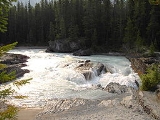
The river has three waterfalls along its stretch. The first is the Kicking Horse Cascade, a long talus cascade which occurs just below the first highway crossing of the river below Wapta Lake. The second is commonly photographed Natural Bridge Falls near Field.The final and largest is 100 foot high Wapta Falls
Wapta Falls
Wapta Falls is a waterfall located in Yoho National Park in British Columbia, Canada. It is the largest waterfall of the Kicking Horse River, at about high and wide. Its average flow can reach . The name stems from a Nakoda Indian word meaning "river"....
, one of the largest waterfalls in Canada in both volume and width. They are over 500 feet wide.
Kicking Horse River History
The Kicking Horse River offers excitement, history, wildlife and incredible scenery. A wild, untamed river discovered in the 1800s on the famous Palliser Expedition. The history of the wild west is alive along its shores as remnants of a bygone era are still evident. The Kicking Horse River is also blessed with an abundance of wildlife along its corridor. The morning portion of the river which begins in Yoho National Park offers prime wildlife viewing.The River’s unusual name stems from an incident near Wapta Falls in August 1858, Sir James Hector
James Hector
Sir James Hector was a Scottish geologist, naturalist, and surgeon who accompanied the Palliser Expedition as a surgeon and geologist...
writes:
“A little way above this fall one of our pack horses, to escape the fallen timber, plunged into the river, luckily where it formed an eddy, but the banks were so steep that we had great difficulty in getting him out. In attempting to recatch my own horse, which had strayed off while we were engaged with the one in the water, he kicked me in the chest, but I had luckily got close to him before he struck out, so that I did not get the full force of the blow. However, it knocked me down and rendered me senseless for some time. This was unfortunate, as we had seen no tracks of game in the neighbourhood, and were now without food:but I was so hurt that we could not proceed further that day at least” - James Hector chronicles, 1858
Who was James Hector?
As surgeon and geologist to the Palliser ExpeditionPalliser Expedition
The British North American Exploring Expedition, commonly called the Palliser Expedition, explored and surveyed the open prairies and rugged wilderness of western Canada from 1857 to 1860. The purpose was to explore possible routes for the Canadian Pacific Railway and discover new species of plants...
from 1857 to 1860, Hector explored the country from the Red River settlement (Winnipeg) to Vancouver Island. He made many important observations regarding the geology and ethnology of the Canadian West and the Rocky Mountains and discovered the important Kicking Horse Pass, and unintentionally gave the Kicking Horse River its name.
Recreation
The river is used by several whitewater rafting companies as well as Kayakers and Canoeists. There are three main sections of the kicking horse river that are run. The upper canyon (Accessed via Beaverfoot road off of HWY 1 West) is a class 3-4 whitewater run suitable for canoes, kayaks, and rafts. The middle canyon (accessed via Kicking Horse Rest area just west of the large new bridge over the river) Is an advanced class 4-5 run suitable for experienced Kayakers/Rafters and Canoeists only. This section is not run by commercial rafting companies due to the risk involved. The lower canyon is another class 4-5 whitewater run that is run by commercial rafting companies at suitable water levels. The Kicking Horse is Home to many varieties of fresh water fish also. Therefore used for fishing.Major Tributaries
- Sherbrooke Creek
- Yoho RiverYoho RiverThe Yoho River is a silty, swift tributary of the Kicking Horse River in the Canadian province of British Columbia. The river is located entirely within Yoho National Park.-Course:...
- Emerald RiverEmerald RiverThe Emerald River is a short river in British Columbia. It is about 6.5 km long and drains the waters of Emerald Lake to the Kicking Horse River. The river exits the lake’s south end and flows in a southern direction for about 6.5 km to its mouth which is located at almost exactly the...
- Amiskwi RiverAmiskwi RiverThe Amiskwi River is an approximately 27.1 km river in British Columbia. It is a tributary of the Kicking Horse River. The name Amiskwi is a Cree word for Beavertail...
- Otterhead River
- Ottertail River
- Porcupine Creek
- Beaverfoot River
- Glenogle Creek
See also
- List of tributaries of the Columbia River
- Divide CreekDivide CreekDivide Creek is a short creek near Kicking Horse Pass on the British Columbia/Alberta border...
- List of British Columbia rivers

