Kisdon Force
Encyclopedia


Waterfall
A waterfall is a place where flowing water rapidly drops in elevation as it flows over a steep region or a cliff.-Formation:Waterfalls are commonly formed when a river is young. At these times the channel is often narrow and deep. When the river courses over resistant bedrock, erosion happens...
s on the River Swale
River Swale
The River Swale is a river in Yorkshire, England and a major tributary of the River Ure, which itself becomes the River Ouse, emptying into the North Sea via the Humber Estuary....
in Swaledale
Swaledale
Swaledale is one of the northernmost dales in the Yorkshire Dales National Park in northern England. It is the dale of the River Swale on the east side of the Pennines in North Yorkshire.-Geographical overview:...
, England
England
England is a country that is part of the United Kingdom. It shares land borders with Scotland to the north and Wales to the west; the Irish Sea is to the north west, the Celtic Sea to the south west, with the North Sea to the east and the English Channel to the south separating it from continental...
. The falls are situated at grid reference within the Yorkshire Dales National Park
Yorkshire Dales
The Yorkshire Dales is the name given to an upland area in Northern England.The area lies within the historic county boundaries of Yorkshire, though it spans the ceremonial counties of North Yorkshire, West Yorkshire and Cumbria...
in the county of North Yorkshire
North Yorkshire
North Yorkshire is a non-metropolitan or shire county located in the Yorkshire and the Humber region of England, and a ceremonial county primarily in that region but partly in North East England. Created in 1974 by the Local Government Act 1972 it covers an area of , making it the largest...
, 500 metres downstream from the small hamlet of Keld
Keld, North Yorkshire
Keld is a hamlet in the English county of North Yorkshire. It is situated on Swaledale, in the Yorkshire Dales. The name derives from the Viking word Kelda meaning a spring, and the village was once called Appletre Kelde - the spring near the apple trees.Keld is the crossing point of the Coast to...
.
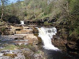
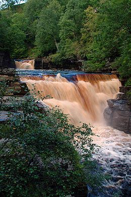
Kisdon Force is one of several waterfalls on the Swale in the Keld area, the others being East Gill Force
East Gill Force
East Gill Force is a waterfalls in Swaledale, 300 metres to the east of the hamlet of Keld, in the Yorkshire Dales National Park, North Yorkshire, England. The falls are located on East Gill at grid reference , just before its confluence with the River Swale at the point where the Pennine Way and...
, Catrake Force
Catrake Force
Catrake Force is a waterfall on the river Swale in North Yorkshire, England. It is not visible from the road but only a short walk to reach it. It comprises a series of 4 steps each its own small waterfall and each with a very different character with the largest single drop being about .It lies on...
and Wain Wath Force
Wain Wath Force
Wain Wath Force is a waterfall situated on the River Swale in the Yorkshire Dales National Park, North Yorkshire, England. The falls are located at grid reference , one kilometre upstream from the hamlet of Keld which has three other waterfalls in its vicinity, namely Kisdon Force, East Gill Force...
. All occur where the river cuts a gorge through the Carboniferous
Carboniferous
The Carboniferous is a geologic period and system that extends from the end of the Devonian Period, about 359.2 ± 2.5 Mya , to the beginning of the Permian Period, about 299.0 ± 0.8 Mya . The name is derived from the Latin word for coal, carbo. Carboniferous means "coal-bearing"...
limestone
Limestone
Limestone is a sedimentary rock composed largely of the minerals calcite and aragonite, which are different crystal forms of calcium carbonate . Many limestones are composed from skeletal fragments of marine organisms such as coral or foraminifera....
between the hills of Kisdon
Kisdon
Kisdon, also called Kisdon Hill is a fell situated in upper Swaledale in the Yorkshire Dales National Park in North Yorkshire, England.- Geography and history :...
and Rogan's Seat
Rogan's Seat
Rogan's Seat is a remote hill located near East Stonesdale and Gunnerside Gill, in the Yorkshire Dales in England.It is a high expanse of moorland that stretches alongside Swaledale, Swinner Gill and Gunnerside Gill...
. The falls in this area are termed forces after the Norse word fors or foss, which means "waterfall". Both upper and lower Kisdon Force can be negotiated by canoeists, although a high degree of skill and experience is needed. The upper falls are rated Grade IV, while the lower falls are rated more difficult at Grade V.
The falls drop 10 metres (32.8 ft) over two cascades and are surrounded by Kisdon Force Woods, a Site of Special Scientific Interest
Site of Special Scientific Interest
A Site of Special Scientific Interest is a conservation designation denoting a protected area in the United Kingdom. SSSIs are the basic building block of site-based nature conservation legislation and most other legal nature/geological conservation designations in Great Britain are based upon...
covering an area of 38 hectares, which consists of mixed broad-leaved woodland
Woodland
Ecologically, a woodland is a low-density forest forming open habitats with plenty of sunlight and limited shade. Woodlands may support an understory of shrubs and herbaceous plants including grasses. Woodland may form a transition to shrubland under drier conditions or during early stages of...
with ash
European Ash
Fraxinus excelsior , is a species of Fraxinus native to most of Europe with the exception of northern Scandinavia and southern Iberia, and also southwestern Asia from northern Turkey east to the Caucasus and Alborz mountains...
, wych elm
Wych Elm
Ulmus glabra, the Wych elm or Scots elm, has the widest range of the European elm species, from Ireland eastwards to the Urals, and from the Arctic Circle south to the mountains of the Peloponnese in Greece; it is also found in Iran...
and rowan
Rowan
The rowans or mountain-ashes are shrubs or small trees in genus Sorbus of family Rosaceae. They are native throughout the cool temperate regions of the Northern Hemisphere, with the highest species diversity in the mountains of western China and the Himalaya, where numerous apomictic microspecies...
trees dominating. In the springtime Primula vulgaris
Primula vulgaris
Primula vulgaris is a species of Primula native to western and southern Europe , northwest Africa , and southwest Asia...
grows profusely in the area. The falls can be easily visited by a riverside path from Keld; however, care should be taken, as the stones around the falls are often wet and slippery. Visitor numbers to the falls are swelled by walkers along the Pennine Way
Pennine Way
The Pennine Way is a National Trail in England. The trail runs from Edale, in the northern Derbyshire Peak District, north through the Yorkshire Dales and the Northumberland National Park and ends at Kirk Yetholm, just inside the Scottish border. The path runs along the Pennine hills, sometimes...
, a long-distance footpath that passes the falls on its way north.

