Kwun Chung
Encyclopedia

Hong Kong
Hong Kong is one of two Special Administrative Regions of the People's Republic of China , the other being Macau. A city-state situated on China's south coast and enclosed by the Pearl River Delta and South China Sea, it is renowned for its expansive skyline and deep natural harbour...
, southwest of Yau Ma Tei
Yau Ma Tei
Yau Ma Tei, also known as Waterloo , is an area in the Yau Tsim Mong District in the south of the Kowloon Peninsula in Hong Kong.-Name:Yau Ma Tei is a phonetic transliteration of the name 油麻地 in Cantonese...
located in the Yau Tsim Mong District
Yau Tsim Mong District
Yau Tsim Mong District is one of 18 districts of Hong Kong, located on western Kowloon peninsula. It is the core urban area of Kowloon. The district has the third highest population density of all districts...
of western Kowloon Peninsula
Kowloon Peninsula
The Kowloon Peninsula is a peninsula that forms the southern part of the main landmass in the territory of Hong Kong. The Kowloon Peninsula and the area of New Kowloon are collectively known as Kowloon....
. South of the area, across Austin Road
Austin Road
Austin Road is a road in Kowloon, Hong Kong. It was named after John Gardiner Austin, Colonial Secretary of Hong Kong from 1868 to 1879.-Location:...
is Tsim Sha Tsui
Tsim Sha Tsui
Tsim Sha Tsui , often abbreviated as TST, is an urbanized area in southern Kowloon, Hong Kong. The area is administratively part of the Yau Tsim Mong District. Tsim Sha Tsui East is a piece of land reclaimed from the Hung Hom Bay now east of Tsim Sha Tsui...
by Victoria Harbour
Victoria Harbour
Victoria Harbour is a natural landform harbour situated between Hong Kong Island and the Kowloon Peninsula in Hong Kong. The harbour's deep, sheltered waters and strategic location on the South China Sea were instrumental in Hong Kong's establishment as a British colony and its subsequent...
. The area contains one of few Nepalese
Nepali people
Nepali people can refer to:*People of Nepal*Ethnic Nepalis of Indian citizenry residing in Gorkhaland area of West Bengal, Sikkim, Assam, Meghalaya, Mizoram and other parts of India.* Indian Gorkhas*Lhotshampas of Bhutan.*Nepali diaspora the world over....
communities in Hong Kong.
In 1979, the MTR
MTR
Mass Transit Railway is the rapid transit railway system in Hong Kong. Originally opened in 1979, the system now includes 211.6 km of rail with 155 stations, including 86 railway stations and 69 light rail stops...
station running through Kwun Chung was named Jordan since it intersected Jordan Road and nearby bus stops were also relabeled Jordan. This resulted in the area being called Jordan
Jordan, Hong Kong
Jordan is an area in the Yau Tsim Mong District of Hong Kong. The unofficial area is named after a road of the same name.-Geography:Jordan is located in the central part of the Yau Tsim Mong District, as suggested by the name of some bus stops nearby...
by residents, since most MTR stations are named after the district or area in which it serves. The issue of district and station naming confusion also occurred with Waterloo Station just to the north which was later renamed Yau Ma Tei Station. Officially the area is still Kwun Chung. The western half contains the Kwun Chung Municipal Services Building on Bowring Street.
History

Kowloon Peninsula
The Kowloon Peninsula is a peninsula that forms the southern part of the main landmass in the territory of Hong Kong. The Kowloon Peninsula and the area of New Kowloon are collectively known as Kowloon....
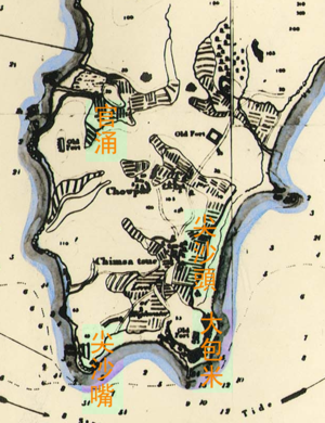
. In the middle of the valley was a hill where two rivers ran west to the sea.
Kwun Chung Fort
The area between Austin RoadAustin Road
Austin Road is a road in Kowloon, Hong Kong. It was named after John Gardiner Austin, Colonial Secretary of Hong Kong from 1868 to 1879.-Location:...
and Jordan Road was originally hilly when Kwun Chung Fort was built by the Chinese (Qing) official Lin Tse-hsu to defend against the British. During the Battle of Kwun Chung in 1839, the fort, together with Tsim Sha Tsui Fort successfully kept British incursions from Kowloon. The fort with the hill was demolished for development during the early British rule of Kowloon and its rock and sand were used for reclamation for the area northwest of Jordan Road. Due to its strategic position, the British Army
British Army
The British Army is the land warfare branch of Her Majesty's Armed Forces in the United Kingdom. It came into being with the unification of the Kingdom of England and Scotland into the Kingdom of Great Britain in 1707. The new British Army incorporated Regiments that had already existed in England...
chose the hill south of Austin Road for the Whitfield Barracks
Whitfield Barracks
Whitfield Barracks were barracks in Tsim Sha Tsui, Kowloon, Hong Kong. The area is now the site of Kowloon Park, where several reconverted buildings remain.It was named after Henry Wase Whitfield, the commander of British Army in Hong Kong.-History:...
and battery. Battery Street was probably named after it.
Demography
While the majority population is Cantonese and other ethnic Chinese, Kwun Chung also contains NepaleseNepali people
Nepali people can refer to:*People of Nepal*Ethnic Nepalis of Indian citizenry residing in Gorkhaland area of West Bengal, Sikkim, Assam, Meghalaya, Mizoram and other parts of India.* Indian Gorkhas*Lhotshampas of Bhutan.*Nepali diaspora the world over....
, mostly from ex-Gurkhas, and other South Asian populations.

