

Lake Memphremagog
Encyclopedia
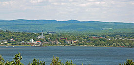
Lake Memphremagog is a fresh water
glacial lake
located between Newport, Vermont
, United States
and Magog, Quebec
, Canada
. The lake is 27 miles (43.5 km) long with 73 percent of the lake's surface area in Quebec
, where it drains into the Magog River
. However, three-quarters of its watershed
, 489 square miles (1,266.5 km²), is in Vermont
. The total is 687 square miles (1,779.3 km²), with 198 square miles (512.8 km²) located in Quebec. In Vermont, the lake lies in parts of the towns of Derby
and Newport
, in addition to the city of Newport
, all in Orleans County
. In Quebec, the lake lies in parts of Austin
, Magog
, Ogden
, Potton
, Saint-Benoît-du-Lac
, and Stanstead Township
, all in Memphrémagog Regional County Municipality
.
The lake elevation is 682 feet (207.9 m) and its maximum recorded depth is 285 feet (86.9 m) located near the international divide. The lake is the third deepest in Vermont It contains 20 islands. Province Island, the largest, is divided by the international border. The name Memphremagog is derived from Algonkian
, in which it means "where there is a big expanse of water".
, sediments, and other pollutants from a variety of sources. In addition, exotic species infestations are a concern, with an existing Eurasian water milfoil population and the potential for a zebra mussel
infestation. Since the 1970s, significant efforts have been made to reduce the polluting effects of direct discharges into the lake and its tributaries, and lake quality has improved.
In 1994, a Lake Memphremagog Watershed Association was formed to focus on solving lake and river issues.
Testing done in 2008 was unable to determine the cause of excessive nitrogen
and phosphorus.
In 2010, a study revealed that farms contribute disproportionately to nutrient loads. Although farms have 16% of total land use in the drainage area, they produce 44% of the runoff. Baseline nutrients for a lake are 14 micrograms of phosphorus per liter of water. The lake was measured at 17 micrograms, 18% above normal. Although the acreage devoted to farming has decreased, the retired land has most often been developed, itself a source of runoff.
, Barton
, and the Black.
In the middle of the winter, the ice can become 3 foot (0.9144 m) thick.
(or Memphré), which has received sightings since the 18th century and continues on in the folklore of the area in a similar vein as the Loch Ness Monster
. It is claimed that Memphre has been spotted as recently as 2000.
 In 1753, the Abenakis brought the ransomed John Stark
down the lake and came ashore where Newport is now.
Rogers' Rangers
were forced to retreat south following their attack on Saint-Francis, Quebec
in 1759. To confound their avenging pursuers, they split up on the east shore of the lake.
The Mountain Maid paddlewheeler operated from 1850 to 1870. The Lady of the Lake steam excursion/ferry paddlewheeler started operating in 1867. It stopped operations in 1917. It was based in Newport. The Anthemis steamer was built in 1909 to carry 300 people. It stopped operating after 1945.
In August 1942, a single-engined Royal Canadian Air Force
training plane crashed into the lake near the west shore near Newport, killing the pilot, its only occupant.
In 2010 the U.S. Fish and Wildlife Service accepted a bequest of 420 acres (170 ha) undeveloped land on the shores the lake on Eagle Point along the border with Canada.
s used in aiding boaters in navigating the waters of the large lake. All three of the original lighthouses have been demolished.
 The Maxfield Point Light was a small lighthouse constructed on the Vermont
side of Lake Memphremagog in 1879. A conical, cast iron
structure, it was 25 feet (7.6 m) tall, with a focal plane 40 feet (12.2 m) above sea level
. It showed a fixed white light
, visible for 10 (16 km) miles. The lighthouse no longer exists; it is unknown what happened to it, or when it was deactivated.
mentions Lake Memphremagog in their 2002 unreleased song Problem Bears; part of their In Violet Light album sessions.
Fresh Water
Fresh Water is the debut album by Australian rock and blues singer Alison McCallum, released in 1972. Rare for an Australian artist at the time, it came in a gatefold sleeve...
glacial lake
Glacial lake
A glacial lake is a lake with origins in a melted glacier. Near the end of the last glacial period, roughly 10,000 years ago, glaciers began to retreat. A retreating glacier often left behind large deposits of ice in hollows between drumlins or hills. As the ice age ended, these melted to create...
located between Newport, Vermont
Newport (city), Vermont
Newport is a city in and the shire town of Orleans County, Vermont, United States. As of the 2000 census, the city population was 5,005. The city contains the largest population of any government in the county, yet encompasses the smallest area....
, United States
United States
The United States of America is a federal constitutional republic comprising fifty states and a federal district...
and Magog, Quebec
Magog, Quebec
Magog is a city in southeastern Quebec, Canada, about east of Montreal at the confluence of Lake Memphremagog--after which the city was named—with the Rivière aux Cerises and the Magog River...
, Canada
Canada
Canada is a North American country consisting of ten provinces and three territories. Located in the northern part of the continent, it extends from the Atlantic Ocean in the east to the Pacific Ocean in the west, and northward into the Arctic Ocean...
. The lake is 27 miles (43.5 km) long with 73 percent of the lake's surface area in Quebec
Quebec
Quebec or is a province in east-central Canada. It is the only Canadian province with a predominantly French-speaking population and the only one whose sole official language is French at the provincial level....
, where it drains into the Magog River
Magog River
The Magog River is a river that drains Lake Memphremagog. The cities of Sherbrooke and Magog, Quebec, lie on the river. Engineers from the University of Sherbrooke have constructed a plastic bridge on the river. - Dams :...
. However, three-quarters of its watershed
Drainage basin
A drainage basin is an extent or an area of land where surface water from rain and melting snow or ice converges to a single point, usually the exit of the basin, where the waters join another waterbody, such as a river, lake, reservoir, estuary, wetland, sea, or ocean...
, 489 square miles (1,266.5 km²), is in Vermont
Vermont
Vermont is a state in the New England region of the northeastern United States of America. The state ranks 43rd in land area, , and 45th in total area. Its population according to the 2010 census, 630,337, is the second smallest in the country, larger only than Wyoming. It is the only New England...
. The total is 687 square miles (1,779.3 km²), with 198 square miles (512.8 km²) located in Quebec. In Vermont, the lake lies in parts of the towns of Derby
Derby, Vermont
Derby is a town in Orleans County, Vermont, United States. The population was 4,604 at the 2000 census. The town contains four unincorporated villages: Beebe Plain, Clyde Pond, Lake Salem and North Derby; and two incorporated villages: Derby Center and Derby Line...
and Newport
Newport (town), Vermont
Newport is a town in Orleans County, Vermont, United States. The population was 1,511 at the 2000 census. The town is referred to by the United States Postal Service and the media as Newport Center, the name of the main settlement of the town.-Town:...
, in addition to the city of Newport
Newport (city), Vermont
Newport is a city in and the shire town of Orleans County, Vermont, United States. As of the 2000 census, the city population was 5,005. The city contains the largest population of any government in the county, yet encompasses the smallest area....
, all in Orleans County
Orleans County, Vermont
Orleans County is one of the four northernmost counties in the U.S. state of Vermont. It borders Canada. In 2010, the population was 27,231. Its county seat is Newport. As in the rest of New England, few governmental powers have been granted to the county...
. In Quebec, the lake lies in parts of Austin
Austin, Quebec
Austin is a municipality on the western shore of Lake Memphremagog, part of the Memphrémagog Regional County Municipality in the Eastern Townships region of Quebec, Canada. Home to known Canadien Celebrities and historical figures such as inventor 'Reginald Fessenden' and actor Jason Westover.'-...
, Magog
Magog, Quebec
Magog is a city in southeastern Quebec, Canada, about east of Montreal at the confluence of Lake Memphremagog--after which the city was named—with the Rivière aux Cerises and the Magog River...
, Ogden
Ogden, Quebec
Ogden is a municipality of 750 people, part of the Memphrémagog Regional County Municipality in the Eastern Townships region of Quebec. It comprises the hamlets of Tomifobia and Graniteville.-References:...
, Potton
Potton, Quebec
Potton is a township of 1,700 people, part of the Memphrémagog Regional County Municipality in the Eastern Townships region of Quebec, 125km southeast of Montreal and next to the United States border, north of North Troy, Vermont. The main village in the township is Mansonville...
, Saint-Benoît-du-Lac
Saint-Benoit-du-Lac, Quebec
Saint-Benoît-du-Lac is a community of 48 people, part of the Memphrémagog Regional County Municipality in the Eastern Townships region of Quebec. It only comprises an abbey and its immediate surrounding lands.-External links:*...
, and Stanstead Township
Stanstead, Quebec (township)
Stanstead is a township of 1,065 people and part of the Memphrémagog Regional County Municipality in the Eastern Townships region of Quebec.Formally, the township consists of two villages: Filch Bay and Georgeville...
, all in Memphrémagog Regional County Municipality
Memphrémagog Regional County Municipality, Quebec
Memphrémagog is a Quebec Regional County Municipality in Canada.-History:After the signing of the Treaty of Paris on September 3, 1783, the American Revolutionary War ended with the establishment of the state of Vermont. The border of Upper Canada was then defined at approximately 45 degrees north...
.
The lake elevation is 682 feet (207.9 m) and its maximum recorded depth is 285 feet (86.9 m) located near the international divide. The lake is the third deepest in Vermont It contains 20 islands. Province Island, the largest, is divided by the international border. The name Memphremagog is derived from Algonkian
Algonquian languages
The Algonquian languages also Algonkian) are a subfamily of Native American languages which includes most of the languages in the Algic language family. The name of the Algonquian language family is distinguished from the orthographically similar Algonquin dialect of the Ojibwe language, which is a...
, in which it means "where there is a big expanse of water".
Ecology
Like many other lakes, Memphremagog is faced with accumulating phosphorusPhosphorus
Phosphorus is the chemical element that has the symbol P and atomic number 15. A multivalent nonmetal of the nitrogen group, phosphorus as a mineral is almost always present in its maximally oxidized state, as inorganic phosphate rocks...
, sediments, and other pollutants from a variety of sources. In addition, exotic species infestations are a concern, with an existing Eurasian water milfoil population and the potential for a zebra mussel
Zebra mussel
The zebra mussel, Dreissena polymorpha, is a small freshwater mussel. This species was originally native to the lakes of southeast Russia being first described in 1769 by a German zoologist Peter Simon Pallas in the Ural, Volga and Dnieper rivers. They are still found nearby, as Pontic and Caspian...
infestation. Since the 1970s, significant efforts have been made to reduce the polluting effects of direct discharges into the lake and its tributaries, and lake quality has improved.
In 1994, a Lake Memphremagog Watershed Association was formed to focus on solving lake and river issues.
Testing done in 2008 was unable to determine the cause of excessive nitrogen
Nitrogen
Nitrogen is a chemical element that has the symbol N, atomic number of 7 and atomic mass 14.00674 u. Elemental nitrogen is a colorless, odorless, tasteless, and mostly inert diatomic gas at standard conditions, constituting 78.08% by volume of Earth's atmosphere...
and phosphorus.
In 2010, a study revealed that farms contribute disproportionately to nutrient loads. Although farms have 16% of total land use in the drainage area, they produce 44% of the runoff. Baseline nutrients for a lake are 14 micrograms of phosphorus per liter of water. The lake was measured at 17 micrograms, 18% above normal. Although the acreage devoted to farming has decreased, the retired land has most often been developed, itself a source of runoff.
Hydrology
Three Vermont rivers directly empty into the lake: the ClydeClyde River (Vermont)
The Clyde River is a tributary of Lake Memphremagog, over long, in northern Vermont in the United States. It is the easternmost of the four major rivers in Orleans County. It is the most powerful of the four within Orleans County, powering several turbines at damsites...
, Barton
Barton River
The Barton River is a tributary of Lake Memphremagog, over long, in northern Vermont in the United States.It runs north from Glover through Barton, Brownington, Coventry and drains through Newport into Lake Memphremagog's South Bay.-Course:...
, and the Black.
In the middle of the winter, the ice can become 3 foot (0.9144 m) thick.
Memphre
Some claim Lake Memphremagog contains a reptile-like monster named MemphreMemphre
Memphre is a reptile-like lake monster that is said to live in the murky Lake Memphremagog, Quebec, Canada.-History:Memphre is often described as much like the Loch Ness Monster. While Memphre and most other lake monsters are disputed by many scientists, sightings persist and Memphre was last seen...
(or Memphré), which has received sightings since the 18th century and continues on in the folklore of the area in a similar vein as the Loch Ness Monster
Loch Ness Monster
The Loch Ness Monster is a cryptid that is reputed to inhabit Loch Ness in the Scottish Highlands. It is similar to other supposed lake monsters in Scotland and elsewhere, though its description varies from one account to the next....
. It is claimed that Memphre has been spotted as recently as 2000.
History
John Stark
John Stark was a New Hampshire native who served as a major general in the Continental Army during the American Revolution. He became widely known as the "Hero of Bennington" for his exemplary service at the Battle of Bennington in 1777.-Early life:John Stark was born in Londonderry, New...
down the lake and came ashore where Newport is now.
Rogers' Rangers
Rogers' Rangers
Rogers' Rangers was an independent company of colonial militia, attached to the British Army during the Seven Years War . The unit was informally trained by Major Robert Rogers as a rapidly deployable light infantry force tasked with reconnaissance and conducting special operations against distant...
were forced to retreat south following their attack on Saint-Francis, Quebec
Saint-François-du-Lac, Quebec
Saint-François-du-Lac is a community in the Nicolet-Yamaska Regional County Municipality of Quebec, Canada. The population as of the Canada 2006 Census was 2,002...
in 1759. To confound their avenging pursuers, they split up on the east shore of the lake.
The Mountain Maid paddlewheeler operated from 1850 to 1870. The Lady of the Lake steam excursion/ferry paddlewheeler started operating in 1867. It stopped operations in 1917. It was based in Newport. The Anthemis steamer was built in 1909 to carry 300 people. It stopped operating after 1945.
In August 1942, a single-engined Royal Canadian Air Force
Royal Canadian Air Force
The history of the Royal Canadian Air Force begins in 1920, when the air force was created as the Canadian Air Force . In 1924 the CAF was renamed the Royal Canadian Air Force and granted royal sanction by King George V. The RCAF existed as an independent service until 1968...
training plane crashed into the lake near the west shore near Newport, killing the pilot, its only occupant.
In 2010 the U.S. Fish and Wildlife Service accepted a bequest of 420 acres (170 ha) undeveloped land on the shores the lake on Eagle Point along the border with Canada.
Lighthouses
Lake Memphremagog is known to have had at least three lighthouseLighthouse
A lighthouse is a tower, building, or other type of structure designed to emit light from a system of lamps and lenses or, in older times, from a fire, and used as an aid to navigation for maritime pilots at sea or on inland waterways....
s used in aiding boaters in navigating the waters of the large lake. All three of the original lighthouses have been demolished.
Maxfield Point Light
Vermont
Vermont is a state in the New England region of the northeastern United States of America. The state ranks 43rd in land area, , and 45th in total area. Its population according to the 2010 census, 630,337, is the second smallest in the country, larger only than Wyoming. It is the only New England...
side of Lake Memphremagog in 1879. A conical, cast iron
Cast iron
Cast iron is derived from pig iron, and while it usually refers to gray iron, it also identifies a large group of ferrous alloys which solidify with a eutectic. The color of a fractured surface can be used to identify an alloy. White cast iron is named after its white surface when fractured, due...
structure, it was 25 feet (7.6 m) tall, with a focal plane 40 feet (12.2 m) above sea level
Sea level
Mean sea level is a measure of the average height of the ocean's surface ; used as a standard in reckoning land elevation...
. It showed a fixed white light
Characteristic light
A light characteristic is a graphic and text description of a navigational light sequence or colour displayed on a nautical chart or in a Light List with the chart symbol for a lighthouse, lightvessel, buoy or sea mark with a light on it. The graphic indicates how the real light beacon may be...
, visible for 10 (16 km) miles. The lighthouse no longer exists; it is unknown what happened to it, or when it was deactivated.
Newport Wharf Light
The Newport Wharf Light was a tower that was built in the Newport section of Lake Memphremagog in 1879. The lighthouse was a steel skeleton tower, painted red, that was fixed on a concrete foundation. The tower showed a fixed red light that was visible for up to 12 miles (19.3 km), with the height of the focal plane being 37 feet (11.2 m). As with the Maxfield Point Lighthouse, the date this lighthouse was demolished is unknown.Whipple Point Light
Whipple Point Light was a tower that was built on the end of a pier on Whipple Point in Lake Memphremagog. Built in 1879, the tower was constructed of wood in a hexagonal shape and stood 13 feet (4 m). The light was fixed white and was visible from up to 10 miles (16 km) away, with a focal plane of 25 feet (7.6 m). The lighthouse was deactivated around 1906 and was demolished at an unknown date.Economy
The watershed in Vermont is largely agricultural and forest land with residential development increasing in recent years in both Vermont and Quebec.Pop Culture
The Canadian band The Tragically HipThe Tragically Hip
The Tragically Hip, often referred to simply as The Hip, is a Canadian rock band from Kingston, Ontario, consisting of Gordon Downie , Paul Langlois , Rob Baker , Gord Sinclair and Johnny Fay . Since their formation in 1983 they have released 12 studio albums, two live albums, and 46 singles...
mentions Lake Memphremagog in their 2002 unreleased song Problem Bears; part of their In Violet Light album sessions.
External links
- Lake Memphremagog environmental document
- Basin Planning
- Restoring Water Quality in the Lake Memphremagog Basin: Clyde River Phase I & II Stream Geomorphic Assessments
- The International Dracontology Society of Lake Memphremagog
- Memphre, the Sea Serpent of Lake Memphremagog
- Memphré Quebec
- International Lake Environment Committee