
Landmannalaugar
Encyclopedia

Volcano
2. Bedrock3. Conduit 4. Base5. Sill6. Dike7. Layers of ash emitted by the volcano8. Flank| 9. Layers of lava emitted by the volcano10. Throat11. Parasitic cone12. Lava flow13. Vent14. Crater15...
Hekla
Hekla
Hekla is a stratovolcano located in the south of Iceland with a height of . Hekla is one of Iceland's most active volcanoes; over 20 eruptions have occurred in and around the volcano since 874. During the Middle Ages, Icelanders called the volcano the "Gateway to Hell."Hekla is part of a volcanic...
in southern section of Iceland
Iceland
Iceland , described as the Republic of Iceland, is a Nordic and European island country in the North Atlantic Ocean, on the Mid-Atlantic Ridge. Iceland also refers to the main island of the country, which contains almost all the population and almost all the land area. The country has a population...
's highlands.
The Landmannalaugar area is a popular tourist destination and hiking hub in Iceland
Iceland
Iceland , described as the Republic of Iceland, is a Nordic and European island country in the North Atlantic Ocean, on the Mid-Atlantic Ridge. Iceland also refers to the main island of the country, which contains almost all the population and almost all the land area. The country has a population...
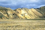
's highlands. The area displays a number of unusual geological elements, like the multicolored rhyolite
Rhyolite
This page is about a volcanic rock. For the ghost town see Rhyolite, Nevada, and for the satellite system, see Rhyolite/Aquacade.Rhyolite is an igneous, volcanic rock, of felsic composition . It may have any texture from glassy to aphanitic to porphyritic...
mountains and expansive lava fields, not far from the service center. The many mountains in the surrounding area display a wide spectrum of colors including pink, brown, green, yellow, blue, purple, black, and white. Two of the most popular mountains among hikers are Bláhnjúkur
Bláhnjúkur
Bláhnjúkur is a volcano in the south of Iceland. Its height is about 940 m.Its name translates to blue peak in English. This comes from the blue-black colour of its sides. The colour is due to volcanic ash and lava flows....
(meaning "blue peak") and Brennisteinsalda
Brennisteinsalda
The Brennisteinsalda is a volcano in the south of Iceland. Its height is about 855 m. It is situated near Landmannalaugar and not far from Hekla....
(meaning "sulphur wave").
Tourists visit the area from June through late September, after which time the road is closed. A mountain lodge, in operation since 1951, can accommodate 78 people and has basic amenities. It is located centrally near natural geothermal hot springs, also popular with tourists.
Routes
Two routes lead to Landmannalaugar and one of them is accessible by regular car, though the road is rough (stones the size of fists are not uncommon). The easiest route to Landmannalaugar is to take either Rd. 30 from the mainroad and change into 32, cross the Sultartangi hydro-electric dam, going onto 26, then F208 and just before arriving in Landmannalaugar, making a right turn to F224. Road 26 can also be accessed directly from Rd. 1 just before arriving in the small village of Hella, crossing through typical Icelandic farmlands.Icelandic horse
Icelandic horse
The Icelandic horse is a breed of horse developed in Iceland. Although the horses are small, at times pony-sized, most registries for the Icelandic refer to it as a horse. Icelandic horses are long-lived and hardy. In their native country they have few diseases; Icelandic law prevents horses from...
riding is also available in the area. The horse riding trips visit places which can often be difficult to access on foot and not accessible by car as there are no official roads, as an example into Jökulgil (Glacier Valley).
From late June and through the summer, a couple from the Westfjords
Westfjords
The Westfjords or West Fjords is the name for the large peninsula in northwestern Iceland. It is connected to the rest of Iceland by a 7 km wide isthmus between Gilsfjörður and Bitrufjörður. The Westfjords are very mountainous; the coastline is heavily indented by dozens of fjords surrounded by...
come and serve food and coffee to travelers in their green bus-shop, Fjallafang, as well as selling other things useful to travelers.
Landmannalaugar is the usual starting point for a four day long hiking trail aptly called Laugavegur
Laugavegur
The Laugavegur is a famous trekking route in South-West Iceland from the hot springs area of Landmannalaugar to the glacial valley of Þórsmörk. It is noted for the wide variety of landscapes that are experienced in just . The route is typically completed over 2–4 days with potential stops at the...
, as the main shopping street in Reykjavík
Reykjavík
Reykjavík is the capital and largest city in Iceland.Its latitude at 64°08' N makes it the world's northernmost capital of a sovereign state. It is located in southwestern Iceland, on the southern shore of Faxaflói Bay...
city center is called the same and is referred to the herds of people that walk the trail every day. The name actually means "The Landmannalaugar Trail", "Laugar" being a shortened version for "Landmannalaugar". The usual four day trail ends in Þórsmörk
Þórsmörk
Thórsmörk is a mountain ridge in Iceland that was named after the Norse god Thor . It is situated in the south of Iceland between the glaciers Tindfjallajökull and Eyjafjallajökull...
, but one or two days can be added, trekking then all the way to Skógar
Skógar
Skógar , literally forests, is a small Icelandic village with a population of roughly 25 located at the south of the Eyjafjallajökull glacier, in the municipality of Rangárþing eystra....
nearly at the coast via Fimmvörðuháls
Fimmvörðuháls
Fimmvörðuháls is the area between the glaciers Eyjafjallajökull and Mýrdalsjökull in southern Iceland. The route between Skógar and Thórsmörk goes through this pass and is one of the most popular walking routes in Iceland, despite being 22 km long and involving 1,000 m of climbing...
between the two glaciers Eyjafjallajökull
Eyjafjallajökull
Eyjafjallajökull is one of the smaller ice caps of Iceland, situated to the north of Skógar and to the west of Mýrdalsjökull. The ice cap covers the caldera of a volcano with a summit elevation of . The volcano has erupted relatively frequently since the last glacial period, most recently in...
and Mýrdalsjökull
Mýrdalsjökull
Mýrdalsjökull mire dale glacier" or " mire valley glacier") is a glacier in the south of Iceland. It is situated to the north of Vík í Mýrdal and to the east of the smaller glacier Eyjafjallajökull. Between these two glaciers is Fimmvörðuháls pass. Its peak reaches in height and in 1980 it covered...
.
The huts on the Laugavegur and Fimmvörðuháls trails are (from north to south):
- Landmannalaugar
- Hrafntinnusker
- Álftavatn
- Hvanngil
- Botnar
- Þórsmörk
- Fimmvörðuháls
External links
Information:- The official Landmannalaugar information site
- Ferðafélag Íslands; for booking huts on the Laugavegur hiking trail
Photos: