
Hekla
Encyclopedia
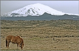
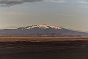
Hekla (ˈhɛʰkla) is a stratovolcano
located in the south of Iceland
with a height of 1491 metres (4,892 ft). Hekla is one of Iceland's most active volcano
es; over 20 eruptions have occurred in and around the volcano since 874. During the Middle Ages
, Icelanders called the volcano the "Gateway to Hell
."
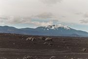
Hekla is part of a volcanic ridge, 40 kilometres (25 mi) long. However, the most active part of this ridge, a fissure
about 5.5 km (3.4 mi) long named Heklugjá, is considered to be the volcano Hekla proper. Hekla looks rather like an overturned boat, with its keel
being in fact a series of craters, two of which are generally the most active.
The volcano's frequent large eruptions have covered much of Iceland with tephra
and these layers can be used to date eruptions of Iceland's other volcanos. 10% of the tephra created in Iceland in the last thousand years has come from Hekla, amounting to 5 km3. The volcano has produced one of the largest volumes of lava
of any in the world in the last millennium, around 8 km3.
_detail_from_map_of_iceland_1585.jpg) In Icelandic
In Icelandic
Hekla is the word for a short hooded cloak which may relate to the frequent cloud cover on the summit. An early Latin
source refers to the mountain as Mons Casule
.
After the eruption of 1104, stories (which were probably spread deliberately through Europe by Cistercian monks) told that Hekla was the gateway to Hell. The Cistercian monk Herbert of Clairvaux
wrote in his De Miraculis (without naming Hekla): A poem by the monk Benedeit from circa 1120 about the voyages of Saint Brendan mentions Hekla as the prison of Judas
.
The Flatey Book Annal wrote of the 1341 eruption that people saw large and small birds flying in the mountain's fire which were taken to be souls.
In the 16th century Caspar Peucer
wrote that the Gates of Hell could be found in "the bottomless abyss of Hekla Fell". The belief that Hekla was the gate to Hell persisted until the 1800s. There is still a legend that witches gather on Hekla for Easter
.
and stratovolcano
(built from mixed lava and tephra eruptions) sited at a rift-transform
junction in the area where the south Iceland seismic zone and eastern volcanic zone meet. The unusual form of Hekla is found on very few volcanoes around the world, notably Callaqui
in Chile
. Hekla is situated on a long volcanic ridge of which the 5.5 km Heklugjá fissure is considered Hekla proper. This fissure opens along its entire length during major eruptions and is fed by a magma reservoir
estimated to have a top 4 km below the surface with centroid
2.5 km lower.
The tephra produced by its eruptions is high in fluorine
which is poisonous to animals. Hekla's basaltic andesite
lava generally has a SiO2
content of over 54%, compared to the 45-50% of other nearby transitional alkaline basalt eruptions (see TAS classification
).
It is the only Icelandic volcano to produce calc-alkaline
lavas.
Phenocryst
s in Hekla's lava can contain plagioclase
, pyroxene
, titanomagnetite, olivine
& apatite
.
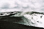
When not erupting Hekla is often covered with snow and small glacier
s, it is also unusually aseismic with activity
only starting 30–80 minutes before an eruption. Hekla is located on the mid-ocean ridge, a diverging plate boundary.
Hekla is closely studied today for parameters such as strain
, tilt, deformation and other movement and seismic activity. Earthquakes in the volcano's vicinity are generally below magnitude
2 while it is dormant and magnitude 3 when erupting.
 The earliest recorded eruption of Hekla took place in 1104, since then there have been between twenty and thirty considerable eruptions, with the mountain sometimes remaining active for periods of six years with little pause. Eruptions in Hekla are extremely varied and difficult to predict. Some are very short (a week to ten days) whereas others can stretch into months and years (the 1947 eruption started March 29, 1947 and ended April 1948). But there is a general correlation: the longer Hekla goes dormant, the larger and more catastrophic its opening eruption will be. The most recent eruption was on February 26, 2000.
 One of the largest Holocene
eruptions in Iceland was the Hekla 3
(or H3) eruption of (950 BC) (1159 BC) which threw about 7.3 km3 of volcanic rock
into the atmosphere, placing its Volcanic Explosivity Index
(VEI) at 5. This would have cooled temperatures in the northern parts of the globe for a few years afterwards. Traces of this eruption have been identified in Scottish peat bogs, and in Ireland a study of tree rings dating
from this period has shown negligible tree ring growth for a decade.
Unless otherwise stated eruption dates are from Global Volcanism Program, other sources disagree.
Hekla 3,4 and 5 produced huge amounts of rhyolitic ash and tephra, covering 80% of Iceland and providing a useful date marker in soil profiles in other parts of Europe such as Orkney, Scandinavia and elsewhere. H3 and H4 produced the largest layers of tephra in Iceland since the last Ice Age
. During the last 7000 years one third of the volcanic ash deposited in Scandinavia, Germany, Ireland and the UK originated from Hekla.
 Hekla had been dormant for at least 250 years when it erupted explosively in 1104 (probably in the autumn), covering over half of Iceland (55,000 km2) with 1.2 km3 / 2.5 km3 of rhyodacitic
tephra
. This was the second largest tephra eruption in the country in historical times with a VEI of 5 like H3. Farms upwind of the volcano in Þjórsárdalur valley (15 km away), Hrunamannaafréttur (50 km away) and Lake Hvítárvatn
(70 km away) were abandoned due to the damage. The eruption caused Hekla to become famous throughout Europe.
and 0.2 km3 of tephra. It is likely to be the source of the Efrahvolshraun lava on the volcano's west. The 1206 and 1222 eruptions, the first of which began on December 4, were not large (VEIs of 3 and 2 respectively) and distributed around 0.24 km3 of tephra mainly to the northeast.
of land with 0.31 km3 of tephra. Over 0.5 km3 of lava was also expelled. The tephra caused significant damage to the settlements of Skagafjördur and Fljót leading to over 500 deaths that winter.
The material output from this eruption had SiO2 levels of between 56% and 64% and apart from a slight abundance of olivine
the lava was generally typical of Hekla eruptions.
.
In late 1389 Hekla erupted again (VEI 3), starting with a large ejection of tephra to the southeast. Later "the eruption fissure moved itself out of the mountain proper and into the woods a little above Skard". Skard and another nearby farm were destroyed by a large lava flow that now forms the 12.5 km2 Nordurhraun. In total around 0.3 km3 of lava and 5×10⁷ m3 of tephra were produced. Another eruption may have occurred in around 1440 at Raudölder, despite being close to Hekla this is not classed as an eruption of Hekla based on the SiO2
content of the lava.
 Details of the 1510 eruption were not recorded until a century later. It started on July 25 and was particularly violent, (VEI 4) firing volcanic bombs as far as Vördufell, 40 km west. Tephra was deposited over Rangárvellir, Holt and Landeyjar, 0.2 km3 in total. A man in Landsveit was killed.
The 1597 (VEI 4) eruption commenced on January 3 and lasted for over 6 months. 0.15 km3 of tephra was deposited to the south-southeast, damaging Mýrdalur.
s and tsunami
. The tephra was deposited to the northwest, destroying and damaging farms and woodland in Thjórsárdalur, Land, Hreppar and Biskupstungur. Fine ash from the eruption reached Norway. There was also damage to wildlife with significant numbers of trout
, salmon
, ptarmigan and farm animals dying.
The eruption of 1766 was much larger (VEI 4) and produced the second largest lava flow, 1.3 km3 covering 65 km2, and third largest tephra volume, 0.24 km3, of any Icelandic volcano during the inhabited era. The eruption started at around 3:30 am on April 5, 1766 and did not stop until May 1768. Initially a 2–4 cm layer of tephra was deposited over Austur-Húnavatnssýsla and Skagafjördur, resulting in the deaths of both fish and livestock. Rangárvellir, Land and Hreppar also suffered damage. During the eruption up to 0.5 m lava bombs were thrown 15–20 km away and a flooding was caused by the sudden melting of snow and ice on Hekla's slopes.
The eruption did not finish until around April 5, 1846. Initially in this VEI 4 eruption tephra was produced at 20,000 m3s−1. The tephra deposition (0.17 km3) was mainly to the east-southeast, immediately to the east of Hekla the layer was 20–40 cm deep. Fine ash was carried to the Faroes, Shetland and Orkney. Lava flows to the west and northwest covered an area of 25 km2 with 0.63 km3 of lava. Large quantities of dark ash were deposited over pasture in the same directions leading to many livestock deaths through fluorosis for the next two years.
Small eruptions (VEI 2) occurred between February 27, 1878 and April 1878 and then April 25, 1913 and May 18, 1913. These were around 10 km east of Hekla, the first produced 0.2 km3 of lava from two parallel fissures covering 15.5 km2. The second caused large fissures at Mundafell and Lambafit which produced 3.8 and 6.3 km2 of lava respectively.
 The 1947 eruption started on March 29, 1947 and ended on April 21, 1948. At VEI 4 it is likely that this was both the second greatest lava eruption of Hekla whilst Iceland was inhabited and the second greatest lava eruption in the world in the period 1900-1970. A total lava volume 0.8 km3 was produced with 0.21 km3 of tephra. The height of Hekla was 1447 m before the eruption, increasing to a maximum of 1503 m, before dropping to 1491 m subsequently.
and increased the eruption intensity until it covered a 4 km fissure on the ridge.
For the first hours the eruption was Plinian, after that it became Vesuvian. The cloud from the eruption had ascended to a height of 30 km by 7:08 am, the wind then carried it southwards towards the Eyjafjallajökull
glacier, turning it black. Pumice first landed on Fljótshlíd at around 7:10 am and tephra and ash continued falling until it formed a 3–10 cm layer. A lava bomb that landed 32 km from Hekla was 0.5 m across and weighed 20 kg. Between Vatnafjöll and Hekla a layer of tephra up to a metre thick was deposited including bombs with a diameter larger than this. Bombs with areas of 50 m2 were dropped onto the slopes of Hekla, up to 1 km away.
51 hours after the eruption had started ash fell on Helsinki
, Finland having covered 2860 km in this time.
The initial tephra production rate in the first 30 minutes of the eruption was 75,000 m3s−1, dropping to 22,000 m3s−1 for the next half hour. The initial phase produced 0.18 km3 of tephra, equating to 4.5×10⁷m3 of solid rock, covering 3,130 km2 of land and sea. 98 farms were damaged by the eruption but only 2 were no longer farmed in 1970. A large volunteer effort was mobilized to clear the tephra - around 1000 man-days by the end of July. The eruption produced around 3 Ml of water (snowmelt and directly from the fissure) which caused flooding of the Ytri Rangá
river.
In the first 20 hours of the eruption approximately 3,500 m3s−1 of lava was produced from the fissure dividing into various branches and covering 12–15 km2. On the second day 8 distinct eruption column
s were discernable. A crater formed at 860 m called the Lava Crater (Hraungígur) producing a constant flow of lava. Another crater named the Shoulder Crater (Axlargígur) produced a column of smoke every 10 s together with loud explosions that created visible compression waves in the smoke. By the fourth, fifth and sixth days the eruption was greatly diminished and only the shoulder and summit craters were erupting explosively.
 The explosive eruption
increased in strength from 9–12 April and then from April 28 reduced again. On May 3 the volcano stopped throwing out lava in sudden explosions from its craters and changed to continuously ejecting tephra and ash for long periods, until early June when this reduced. On September 2 the Shoulder Crater had a 960 m circumference at its top and the Summit Crater a 700 m circumference at its highest point, 90 m above the ridge. Sandy tephra and ash fell over Iceland in May and June, sometimes making it dark in the daytime near to Hekla. The tephra caused fluorine poisoning of grazing sheep, making them unable to walk. That winter more craters formed, building up cones. Explosive activity had ceased six months after the first eruption. Lava flowed from the Lava Crater continuously during the eruption, starting at a rate of over 100 m3s−1, dropping to 5–10 m3s−1 in April and early May at a speed of around 20 cms−1 before increasing, eventually reaching 150 m3s−1 at the end of June and at similar levels until mid-July with a peak flow speed of 2-2.5 ms−1. From there it gradually decreased to under 10 m3s−1 in November. Initially the lava comprised 57-58% SiO2 and 11% Fe2O3, from the time of peak flow onwards this changed to 54% SiO2 and 13.5% Fe2O3.
The lava river sometimes ran through tunnels
before emerging again. The lava front had a height of up to 15 m. On June 15 and 16 a branch of lava flow to the south of Melfell travelled over 1 km in 30 hours before slowing and stopping by June 21, 7.8 km from the Lava Crater. The longest lava stream produced was 8 km long and stopped in Stóraskógsbotnar. A scientist filming one of the lava streams on November 2 was hit by a block of lava and killed.
The lava flow stopped after 13 months on April 21 having covered 40 km2 and with a maximum depth of 100 m. The lava beds produced were mainly the ʻAʻā lava type with Pāhoehoe and lava a budella areas. In April and May 1948 CO2 emitted from cracks in the ground pooled in hollows near to Hekla killing 15 sheep and some wild animals and birds. In total 24,000 tonnes of CO2 was emitted. Ditches were dug by farmers to drain these hollows and the CO2 emission had stopped by the end of the year.
 The 1970 eruption of Hekla started at 9:23 pm on May 5, 1970 and lasted until July 5. It had a VEI of 3 and produced 0.2 km3 of lava covering an area of 18.5 km2 and 6.6×10 7m3 of tephra, deposited over an area of 40,000 km2, mainly to the northwest of the volcano.
The main Hekla fissure only erupted at its far southwest end, most of the eruption was from other fissures nearby. The eruption stopped in the SSW on May 10 and in Hlídargígar on May 20 but a new fissure opened on the same day and lava flowed from this until July 5. The lava was andesite containing olivine, similar to the lava produced later in the eruption of 1947.
, 15 km away, at 9:35 pm causing people to evacuate. The eruption seems to have started in 2 locations at the same time - to the Shoulder crater's SSW and below the Lava Crater. At 10:30 pm a crater at 780 m was producing a lava column which reached an altitude of around 1000 m. During the night a 700 m high lava fountain
was thrown up from the main crater. A 500 m long fissure starting below the Lava Crater opened and lava fountains and other lava flows emanated from it. One hour into the eruption a new 400 m fissure opened to the NE producing two main lava fountains and shortly after another adjoining fissure opened producing lava fountains to a height of 500 m. At around midnight another fissure opened NW of the Lava Crater, later hurling an over 300 m long lava fountain, 200–300 m into the air. By midnight lava had already covered over 1 km2 and this extended to 7.5 km2 by next morning implying a flow rate
of around 1500 m3s−1.
For the first two hours tephra was produced at the rate of 10,000 m3s−1. The cloud from the eruption, which had reached 53000 feet (16,154 m) by 10:10 pm caused a noisy lightning storm. The tephra was transported northwards by the wind causing the sky to turn black in places - 190 km away at Blönduós tephra fell from midnight until 2 am and ash fell on a trawler 330 km away at 2 am. Icelanders sampled the tephra fall in their locality by putting a plate outside to capture everything that fell onto it. This, and other measurements, showed the area covered was long and narrow with the 1 mm contour (an equivalent of 8 tonnes per hectare) extending to the north coast.
s formed around 2% of the material produced by the craters. These were of rock types including basalt, andesite, ignimbrite
and sedimentary rock
.
The eruption became stronger at Skjólkvíar on May 12 with columns of steam attaining a height of 2500 m. The eruption intensity then gradually reduced until it stopped on May 20. The lava field then had an area of 5.8 km2. Later that day a 900 m long fissure opened 1 km north of the main Hlídargígar crater. That night it contained 17 lava fountains, each 20–50 m in height. By the evening of the next day 10-12 craters had formed, each throwing pieces of lava 50–100 m in the air. This row of craters was named Öldugígar. Gradually the number of active craters decreased, the most active of these built a cone 100 m higher than the level of the ridge. Lava flowed from its base until mid-June when the lava cut through the north crater wall. The larger cones produced more tephra, occasionally with lightning within the tephra cloud. By July 5 the eruption had stopped.
can start in sheep at a diet with fluorine content of 25 ppm. At 250 ppm death can occur within a few days. In 1783, 79% of the Icelandic sheep
stock were killed, probably as a result of fluorosis caused by the eruption of Lakagígar. Some of the ash produced in this eruption had a fluorine content of 0.2% and two days after the eruption contaminated grass had a dry weight
content of up to 0.4%. 450 farms and 95,000 sheep were affected by the eruption. Some were kept inside and fed on hay or moved but other farmers were forced to graze their flocks outside. Fluorine poisoning killed over 1500 ewes, 6000 lambs and some horses.
 This VEI3 eruption started at 13:28 on August 17, 1980 and lasted until August 20, 1980. It was a mixed eruption producing a lava volume of 0.12 km3 and a tephra volume of 5.8×10⁷ m3. The fissure opened along a 7 km length. Shortly before the eruption started a steam column was produced, eventually the eruption column
reached a height of 15 km. The main tephra deposits were to the NNE and lasted for around 2 hours. Deposits were 20 cm thick 10 km from the summit, decreasing to <1 mm at the coast 230 km away.
Lava was initially produced from close to the summit, spreading to other parts of the fissure and covering an area of 22 km2 in around 24 hours. The last scoria
were seen on the morning of August 20. This was an unusual eruption both in the short time since the previous eruption - the shortest since 1104, and the length - previous eruptions have lasted from 2 months to 2 years rather than just 3 days.
The 1981 eruption, which is regarded as being a continuation of the previous year's eruption, began at 3 am on April 9, 1981, had a VEI of 2 and produced 3×10⁷ m3 of lava, lasting until April 16, 1981. The eruption threw ash to a height of 6.6 km and a new crater formed at the summit from which 3 lava flows originated. These extended to a maximum of 4.5 km from the volcano, covering 5–6 km2.
 A larger eruption (VEI 3) occurred from January 17, 1991 to March 11, 1991, producing 0.15 km3 of lava and 2×10⁷ m3 of tephra. The eruption, which was preceded by sulpherous smells and earthquakes, started as a Plinian eruption
, producing an ash cloud reaching an altitude of 11.5 km within 10 minutes which had travelled over 200 km north-northeast to the coast within 3 hours. The eruption then moved quickly to producing andesitic lava, the flows eventually covering an area of 23 km2 to an average depth of 6–7 m. Initially part of the Heklugja fissure and other fissures erupted with lava fountains reaching 300 m in height. By the second day the activity stopped in all but one fissure where the main crater formed. During these 2 days 800 m3s−1 of lava were produced, slowing to between 1 m3s−1 and 14 m3s−1 for most of the eruption. This low viscosity
lava had a SiO2 content of approximately 54%.
 The most recent eruption was relatively short, it started at 18:18 on February 26, 2000 and lasted until March 8. It was a VEI3 eruption producing a lava volume of 0.189 km3 DRE
/ 0.29 km3 and 107 m3 of tephra. The eruption went through four phases:
Eruption activity was at a maximum in the first hour and by the first night the fissure on Hekla had opened to a length of 6–7 km. The steam column rose to a height of almost 15 km and ash was transported to Grímsey
. During this eruption, a NASA
DC-8 aeroplane accidentally flew through the plume with all instruments switched on, resulting in unprecedented measurement of a young volcanic plume.
Up until this eruption, it had always been assumed that Hekla was incapable of producing the most dangerous of volcanic phenomena, the pyroclastic flow
. In January 2003, however, a team from the Norvol Institute in Reykjavík
, under the leadership of Dr. Ármann Höskuldsson, reported that they found traces of a pyroclastic flow, roughly 5 km long, stretching down the side of the mountain. This will call for a reappraisal of volcanic eruptions of the basic
rock type, which up to now were generally thought not to produce large pyroclastic flows. It will also require that the public and curious spectators who always rush to the scene at the start of a new outbreak, be kept much further away from the volcanic activity than was thought necessary during previous outbreaks.
International media reported activity that is interpreted as being close to another eruption in July 2011 while Icelandic news sources claim otherwise.
, a 90,000 ha reforesting project is running to restore the previously present birch
and willow
woodland to the slopes of Hekla, starting with soil fertilisation and grass sowing. This would stabilize the large areas of volcanic ash
, help to reduce erosion by the wind of the frost heaved surface, slow drainage rates and hence water erosion, and ultimately increase biodiversity
. It is the largest reforestation of its type in Europe. After an eruption almost all of the 'safe sites' on new lava flows are colonised by moss
es within 20 years expanding to a homogeneous layer up to 20 cm thick within 50 years.
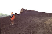
 Hekla is a popular destination for hiking. Following the most recent eruption the path goes most of the way to the summit with the walk taking 3 to 4 hours.
In spring skiing
is possible on short routes around the rim of the crater. In summer there are easy (F) mountaineering
routes also around the crater rim and it is possible to snowcat
to the top in winter. The volcano can be reached using the buses to Landmannalaugar
30 km further east and it is possible to stay or camp at farms in the area.
showed Winter being banished to Hekla in To Winter, one of the works from his Poetical Sketches. and the piece Hekla, Op 52 (1964) by Icelandic composer Jón Leifs
has been called the "loudest classical music
of all time". The requirements for a performance of Hekla include four sets of rocks hit with hammers, steel plates, anvils, sirens, cannons, metal chains, choir, a large orchestra
, and organ.
In the Boston
, United States
area, Hekla pastries can be found - large, upside-down cinnamon roll
s with white sugar icing
spooned over the top to look like the snow-topped volcano.
In the real-time tactics game
Tom Clancy's EndWar
, one of the European
tank-units is named Hekla.
Mt. Hekla was referenced in the third chapter of Herman Melville
's Moby Dick, and in the final chapters of Joan Aiken
's Is
.
Stratovolcano
A stratovolcano, also known as a composite volcano, is a tall, conical volcano built up by many layers of hardened lava, tephra, pumice, and volcanic ash. Unlike shield volcanoes, stratovolcanoes are characterized by a steep profile and periodic, explosive eruptions...
located in the south of Iceland
Iceland
Iceland , described as the Republic of Iceland, is a Nordic and European island country in the North Atlantic Ocean, on the Mid-Atlantic Ridge. Iceland also refers to the main island of the country, which contains almost all the population and almost all the land area. The country has a population...
with a height of 1491 metres (4,892 ft). Hekla is one of Iceland's most active volcano
Volcano
2. Bedrock3. Conduit 4. Base5. Sill6. Dike7. Layers of ash emitted by the volcano8. Flank| 9. Layers of lava emitted by the volcano10. Throat11. Parasitic cone12. Lava flow13. Vent14. Crater15...
es; over 20 eruptions have occurred in and around the volcano since 874. During the Middle Ages
Middle Ages
The Middle Ages is a periodization of European history from the 5th century to the 15th century. The Middle Ages follows the fall of the Western Roman Empire in 476 and precedes the Early Modern Era. It is the middle period of a three-period division of Western history: Classic, Medieval and Modern...
, Icelanders called the volcano the "Gateway to Hell
Hell
In many religious traditions, a hell is a place of suffering and punishment in the afterlife. Religions with a linear divine history often depict hells as endless. Religions with a cyclic history often depict a hell as an intermediary period between incarnations...
."
Hekla is part of a volcanic ridge, 40 kilometres (25 mi) long. However, the most active part of this ridge, a fissure
Fissure vent
A fissure vent, also known as a volcanic fissure or simply fissure, is a linear volcanic vent through which lava erupts, usually without any explosive activity. The vent is usually a few meters wide and may be many kilometers long. Fissure vents can cause large flood basalts and lava channels...
about 5.5 km (3.4 mi) long named Heklugjá, is considered to be the volcano Hekla proper. Hekla looks rather like an overturned boat, with its keel
Keel
In boats and ships, keel can refer to either of two parts: a structural element, or a hydrodynamic element. These parts overlap. As the laying down of the keel is the initial step in construction of a ship, in British and American shipbuilding traditions the construction is dated from this event...
being in fact a series of craters, two of which are generally the most active.
The volcano's frequent large eruptions have covered much of Iceland with tephra
Tephra
200px|thumb|right|Tephra horizons in south-central [[Iceland]]. The thick and light coloured layer at center of the photo is [[rhyolitic]] tephra from [[Hekla]]....
and these layers can be used to date eruptions of Iceland's other volcanos. 10% of the tephra created in Iceland in the last thousand years has come from Hekla, amounting to 5 km3. The volcano has produced one of the largest volumes of lava
Lava
Lava refers both to molten rock expelled by a volcano during an eruption and the resulting rock after solidification and cooling. This molten rock is formed in the interior of some planets, including Earth, and some of their satellites. When first erupted from a volcanic vent, lava is a liquid at...
of any in the world in the last millennium, around 8 km3.
Reputation
Icelandic language
Icelandic is a North Germanic language, the main language of Iceland. Its closest relative is Faroese.Icelandic is an Indo-European language belonging to the North Germanic or Nordic branch of the Germanic languages. Historically, it was the westernmost of the Indo-European languages prior to the...
Hekla is the word for a short hooded cloak which may relate to the frequent cloud cover on the summit. An early Latin
Latin
Latin is an Italic language originally spoken in Latium and Ancient Rome. It, along with most European languages, is a descendant of the ancient Proto-Indo-European language. Although it is considered a dead language, a number of scholars and members of the Christian clergy speak it fluently, and...
source refers to the mountain as Mons Casule
Chasuble
The chasuble is the outermost liturgical vestment worn by clergy for the celebration of the Eucharist in Western-tradition Christian Churches that use full vestments, primarily in the Roman Catholic, Anglican and Lutheran churches, as well as in some parts of the United Methodist Church...
.
After the eruption of 1104, stories (which were probably spread deliberately through Europe by Cistercian monks) told that Hekla was the gateway to Hell. The Cistercian monk Herbert of Clairvaux
Clairvaux Abbey
Clairvaux Abbey is a Cistercian monastery in Ville-sous-la-Ferté, 15 km from Bar-sur-Aube, in the Aube département in northeastern France. The original building, founded in 1115 by St. Bernard, is now in ruins; a high-security prison, the Clairvaux Prison, now occupies the grounds...
wrote in his De Miraculis (without naming Hekla): A poem by the monk Benedeit from circa 1120 about the voyages of Saint Brendan mentions Hekla as the prison of Judas
Judas Iscariot
Judas Iscariot was, according to the New Testament, one of the twelve disciples of Jesus. He is best known for his betrayal of Jesus to the hands of the chief priests for 30 pieces of silver.-Etymology:...
.
The Flatey Book Annal wrote of the 1341 eruption that people saw large and small birds flying in the mountain's fire which were taken to be souls.
In the 16th century Caspar Peucer
Caspar Peucer
Caspar Peucer was a German reformer, physician, and scholar.-Biography:Born in Bautzen, Peucer studied mathematics, astronomy, and medicine at the University of Wittenberg from 1540...
wrote that the Gates of Hell could be found in "the bottomless abyss of Hekla Fell". The belief that Hekla was the gate to Hell persisted until the 1800s. There is still a legend that witches gather on Hekla for Easter
Easter
Easter is the central feast in the Christian liturgical year. According to the Canonical gospels, Jesus rose from the dead on the third day after his crucifixion. His resurrection is celebrated on Easter Day or Easter Sunday...
.
Geology
Hekla has a morphological type between that of a crater rowFissure vent
A fissure vent, also known as a volcanic fissure or simply fissure, is a linear volcanic vent through which lava erupts, usually without any explosive activity. The vent is usually a few meters wide and may be many kilometers long. Fissure vents can cause large flood basalts and lava channels...
and stratovolcano
Stratovolcano
A stratovolcano, also known as a composite volcano, is a tall, conical volcano built up by many layers of hardened lava, tephra, pumice, and volcanic ash. Unlike shield volcanoes, stratovolcanoes are characterized by a steep profile and periodic, explosive eruptions...
(built from mixed lava and tephra eruptions) sited at a rift-transform
Transform fault
A transform fault or transform boundary, also known as conservative plate boundary since these faults neither create nor destroy lithosphere, is a type of fault whose relative motion is predominantly horizontal in either sinistral or dextral direction. Furthermore, transform faults end abruptly...
junction in the area where the south Iceland seismic zone and eastern volcanic zone meet. The unusual form of Hekla is found on very few volcanoes around the world, notably Callaqui
Callaqui
Callaqui is a stratovolcano located in the Bío-Bío Region of Chile. It is a large ice-capped, basaltic andesite volcano which is elongated in the northeast-southwest direction, due to its construction along an 11 km long fissure. Numerous cinder cones and lava flows have erupted from...
in Chile
Chile
Chile ,officially the Republic of Chile , is a country in South America occupying a long, narrow coastal strip between the Andes mountains to the east and the Pacific Ocean to the west. It borders Peru to the north, Bolivia to the northeast, Argentina to the east, and the Drake Passage in the far...
. Hekla is situated on a long volcanic ridge of which the 5.5 km Heklugjá fissure is considered Hekla proper. This fissure opens along its entire length during major eruptions and is fed by a magma reservoir
Magma chamber
A magma chamber is a large underground pool of molten rock found beneath the surface of the Earth. The molten rock in such a chamber is under great pressure, and given enough time, that pressure can gradually fracture the rock around it creating outlets for the magma...
estimated to have a top 4 km below the surface with centroid
Centroid
In geometry, the centroid, geometric center, or barycenter of a plane figure or two-dimensional shape X is the intersection of all straight lines that divide X into two parts of equal moment about the line. Informally, it is the "average" of all points of X...
2.5 km lower.
The tephra produced by its eruptions is high in fluorine
Fluorine
Fluorine is the chemical element with atomic number 9, represented by the symbol F. It is the lightest element of the halogen column of the periodic table and has a single stable isotope, fluorine-19. At standard pressure and temperature, fluorine is a pale yellow gas composed of diatomic...
which is poisonous to animals. Hekla's basaltic andesite
Basaltic andesite
Basaltic andesite is a black volcanic rock containing about 55% silica. Minerals in basaltic andesite include olivine, augite and plagioclase. Basaltic andesite can be found in volcanoes around the world, including in Central America and the Andes of South America. Basaltic andesite is common in...
lava generally has a SiO2
Silicon dioxide
The chemical compound silicon dioxide, also known as silica , is an oxide of silicon with the chemical formula '. It has been known for its hardness since antiquity...
content of over 54%, compared to the 45-50% of other nearby transitional alkaline basalt eruptions (see TAS classification
TAS classification
The TAS classification can be used to assign names to many common types of volcanic rocks based upon the relationships between the combined alkali content and the silica content. These chemical parameters are useful, because the relative proportions of alkalis and silica play an important role in...
).
It is the only Icelandic volcano to produce calc-alkaline
Calc-alkaline
The calc-alkaline magma series is one of two main magma series in igneous rocks, the other magma series being the tholeiitic. A magma series is a series of compositions that describes the evolution of a mafic magma, which is high in magnesium and iron and produces basalt or gabbro, as it...
lavas.
Phenocryst
Phenocryst
thumb|right|300px|[[Granite]]s often have large [[feldspar|feldspatic]] phenocrysts. This granite, from the [[Switzerland|Swiss]] side of the [[Mont Blanc]] massif, has large white [[plagioclase]] phenocrysts, [[triclinic]] [[mineral]]s that give [[trapezium|trapezoid]] shapes when cut through)...
s in Hekla's lava can contain plagioclase
Plagioclase
Plagioclase is an important series of tectosilicate minerals within the feldspar family. Rather than referring to a particular mineral with a specific chemical composition, plagioclase is a solid solution series, more properly known as the plagioclase feldspar series...
, pyroxene
Pyroxene
The pyroxenes are a group of important rock-forming inosilicate minerals found in many igneous and metamorphic rocks. They share a common structure consisting of single chains of silica tetrahedra and they crystallize in the monoclinic and orthorhombic systems...
, titanomagnetite, olivine
Olivine
The mineral olivine is a magnesium iron silicate with the formula 2SiO4. It is a common mineral in the Earth's subsurface but weathers quickly on the surface....
& apatite
Apatite
Apatite is a group of phosphate minerals, usually referring to hydroxylapatite, fluorapatite, chlorapatite and bromapatite, named for high concentrations of OH−, F−, Cl− or Br− ions, respectively, in the crystal...
.
When not erupting Hekla is often covered with snow and small glacier
Glacier
A glacier is a large persistent body of ice that forms where the accumulation of snow exceeds its ablation over many years, often centuries. At least 0.1 km² in area and 50 m thick, but often much larger, a glacier slowly deforms and flows due to stresses induced by its weight...
s, it is also unusually aseismic with activity
Earthquake
An earthquake is the result of a sudden release of energy in the Earth's crust that creates seismic waves. The seismicity, seismism or seismic activity of an area refers to the frequency, type and size of earthquakes experienced over a period of time...
only starting 30–80 minutes before an eruption. Hekla is located on the mid-ocean ridge, a diverging plate boundary.
Hekla is closely studied today for parameters such as strain
Strain (materials science)
In continuum mechanics, the infinitesimal strain theory, sometimes called small deformation theory, small displacement theory, or small displacement-gradient theory, deals with infinitesimal deformations of a continuum body...
, tilt, deformation and other movement and seismic activity. Earthquakes in the volcano's vicinity are generally below magnitude
Moment magnitude scale
The moment magnitude scale is used by seismologists to measure the size of earthquakes in terms of the energy released. The magnitude is based on the seismic moment of the earthquake, which is equal to the rigidity of the Earth multiplied by the average amount of slip on the fault and the size of...
2 while it is dormant and magnitude 3 when erupting.
Eruption history
Historical and prehistoric eruptions
Holocene
The Holocene is a geological epoch which began at the end of the Pleistocene and continues to the present. The Holocene is part of the Quaternary period. Its name comes from the Greek words and , meaning "entirely recent"...
eruptions in Iceland was the Hekla 3
Hekla 3 eruption
The Hekla 3 eruption circa 1000 BC is considered the most severe eruption of Hekla during the Holocene. It threw about 7.3 km3 of volcanic rock into the atmosphere, placing its Volcanic Explosivity Index at 5...
(or H3) eruption of (950 BC) (1159 BC) which threw about 7.3 km3 of volcanic rock
Volcanic rock
Volcanic rock is a rock formed from magma erupted from a volcano. In other words, it is an igneous rock of volcanic origin...
into the atmosphere, placing its Volcanic Explosivity Index
Volcanic Explosivity Index
The Volcanic Explosivity Index was devised by Chris Newhall of the U.S. Geological Survey and Stephen Self at the University of Hawaii in 1982 to provide a relative measure of the explosiveness of volcanic eruptions....
(VEI) at 5. This would have cooled temperatures in the northern parts of the globe for a few years afterwards. Traces of this eruption have been identified in Scottish peat bogs, and in Ireland a study of tree rings dating
Dendrochronology
Dendrochronology or tree-ring dating is the scientific method of dating based on the analysis of patterns of tree-rings. Dendrochronology can date the time at which tree rings were formed, in many types of wood, to the exact calendar year...
from this period has shown negligible tree ring growth for a decade.
| Eruption | Year |
|---|---|
| H-5 | 5050 BC |
| H-Sv | 3900 BC |
| H-4 | 2310±20 BC |
| H-3 | 950 BC |
Unless otherwise stated eruption dates are from Global Volcanism Program, other sources disagree.
Hekla 3,4 and 5 produced huge amounts of rhyolitic ash and tephra, covering 80% of Iceland and providing a useful date marker in soil profiles in other parts of Europe such as Orkney, Scandinavia and elsewhere. H3 and H4 produced the largest layers of tephra in Iceland since the last Ice Age
Ice age
An ice age or, more precisely, glacial age, is a generic geological period of long-term reduction in the temperature of the Earth's surface and atmosphere, resulting in the presence or expansion of continental ice sheets, polar ice sheets and alpine glaciers...
. During the last 7000 years one third of the volcanic ash deposited in Scandinavia, Germany, Ireland and the UK originated from Hekla.
1104 (H1)
Rhyodacite
Rhyodacite is an extrusive volcanic rock intermediate in composition between dacite and rhyolite. It is the extrusive equivalent of granodiorite. Phenocrysts of sodium rich plagioclase, sanidine, quartz, and biotite or hornblende are typically set in an aphanitic to glassy light to intermediate...
tephra
Tephra
200px|thumb|right|Tephra horizons in south-central [[Iceland]]. The thick and light coloured layer at center of the photo is [[rhyolitic]] tephra from [[Hekla]]....
. This was the second largest tephra eruption in the country in historical times with a VEI of 5 like H3. Farms upwind of the volcano in Þjórsárdalur valley (15 km away), Hrunamannaafréttur (50 km away) and Lake Hvítárvatn
Hvítárvatn
Hvítárvatn is a lake in the Highlands of Iceland and the source of glacial river Hvítá. It is located 45 km northeast of Gullfoss. Its surface is about 30 km²; its greatest depth is 84 m....
(70 km away) were abandoned due to the damage. The eruption caused Hekla to become famous throughout Europe.
1158, 1206 and 1222
A VEI of 4 eruption commenced on January 19, 1158 producing over 0.15 km3 of lavaLava
Lava refers both to molten rock expelled by a volcano during an eruption and the resulting rock after solidification and cooling. This molten rock is formed in the interior of some planets, including Earth, and some of their satellites. When first erupted from a volcanic vent, lava is a liquid at...
and 0.2 km3 of tephra. It is likely to be the source of the Efrahvolshraun lava on the volcano's west. The 1206 and 1222 eruptions, the first of which began on December 4, were not large (VEIs of 3 and 2 respectively) and distributed around 0.24 km3 of tephra mainly to the northeast.
1300-1301
This VEI 4 eruption which started on July 11 and lasted for a year was the second largest tephra eruption of Hekla since Iceland was settled, covering 30,000 km2of land with 0.31 km3 of tephra. Over 0.5 km3 of lava was also expelled. The tephra caused significant damage to the settlements of Skagafjördur and Fljót leading to over 500 deaths that winter.
The material output from this eruption had SiO2 levels of between 56% and 64% and apart from a slight abundance of olivine
Olivine
The mineral olivine is a magnesium iron silicate with the formula 2SiO4. It is a common mineral in the Earth's subsurface but weathers quickly on the surface....
the lava was generally typical of Hekla eruptions.
1341, 1389 and 1440
In 1341 a small eruption (VEI 3) started on May 19 and deposited around 5×10⁷ m3 of tephra over the areas west and southwest of Hekla leading to many cattle deaths, probably mainly from fluorosisSkeletal fluorosis
Skeletal fluorosis is a bone disease caused by excessive consumption of fluoride. In advanced cases, skeletal fluorosis causes pain and damage to bones and joints.-Forms:...
.
In late 1389 Hekla erupted again (VEI 3), starting with a large ejection of tephra to the southeast. Later "the eruption fissure moved itself out of the mountain proper and into the woods a little above Skard". Skard and another nearby farm were destroyed by a large lava flow that now forms the 12.5 km2 Nordurhraun. In total around 0.3 km3 of lava and 5×10⁷ m3 of tephra were produced. Another eruption may have occurred in around 1440 at Raudölder, despite being close to Hekla this is not classed as an eruption of Hekla based on the SiO2
Silicon dioxide
The chemical compound silicon dioxide, also known as silica , is an oxide of silicon with the chemical formula '. It has been known for its hardness since antiquity...
content of the lava.
1510 and 1597
The 1597 (VEI 4) eruption commenced on January 3 and lasted for over 6 months. 0.15 km3 of tephra was deposited to the south-southeast, damaging Mýrdalur.
1636-1637 and 1693
The 1636 eruptions was small (VEI 3), starting on May 8, but nevertheless lasted for over a year. The 5×10⁷ m3 of tephra from the eruption damaged pasture to the northeast causing deaths amongst livestock. In 1693 an eruption, which started on January 13 and lasted for over 7 months, was one of Hekla's most destructive (VEI 4). Initially tephra was produced at 60,000 m3s−1, 0.18 km3 during the entire eruption, which also caused laharLahar
A lahar is a type of mudflow or debris flow composed of a slurry of pyroclastic material, rocky debris, and water. The material flows down from a volcano, typically along a river valley. The term is a shortened version of "berlahar" which originated in the Javanese language of...
s and tsunami
Tsunami
A tsunami is a series of water waves caused by the displacement of a large volume of a body of water, typically an ocean or a large lake...
. The tephra was deposited to the northwest, destroying and damaging farms and woodland in Thjórsárdalur, Land, Hreppar and Biskupstungur. Fine ash from the eruption reached Norway. There was also damage to wildlife with significant numbers of trout
Trout
Trout is the name for a number of species of freshwater and saltwater fish belonging to the Salmoninae subfamily of the family Salmonidae. Salmon belong to the same family as trout. Most salmon species spend almost all their lives in salt water...
, salmon
Salmon
Salmon is the common name for several species of fish in the family Salmonidae. Several other fish in the same family are called trout; the difference is often said to be that salmon migrate and trout are resident, but this distinction does not strictly hold true...
, ptarmigan and farm animals dying.
1725 and 1766-1768
A very small eruption, possibly only VEI 1, took place on April 2, 1725 producing flows of lava from locations around Hekla which have since been covered by later lava flows, again these eruptions are not classed as of Hekla itself based on the SiO2 content of the lava.The eruption of 1766 was much larger (VEI 4) and produced the second largest lava flow, 1.3 km3 covering 65 km2, and third largest tephra volume, 0.24 km3, of any Icelandic volcano during the inhabited era. The eruption started at around 3:30 am on April 5, 1766 and did not stop until May 1768. Initially a 2–4 cm layer of tephra was deposited over Austur-Húnavatnssýsla and Skagafjördur, resulting in the deaths of both fish and livestock. Rangárvellir, Land and Hreppar also suffered damage. During the eruption up to 0.5 m lava bombs were thrown 15–20 km away and a flooding was caused by the sudden melting of snow and ice on Hekla's slopes.
1845-1846, 1878 and 1913
Hekla was dormant for more than sixty years before 1845, when it suddenly burst forth on September 2 at 9 am:The eruption did not finish until around April 5, 1846. Initially in this VEI 4 eruption tephra was produced at 20,000 m3s−1. The tephra deposition (0.17 km3) was mainly to the east-southeast, immediately to the east of Hekla the layer was 20–40 cm deep. Fine ash was carried to the Faroes, Shetland and Orkney. Lava flows to the west and northwest covered an area of 25 km2 with 0.63 km3 of lava. Large quantities of dark ash were deposited over pasture in the same directions leading to many livestock deaths through fluorosis for the next two years.
Small eruptions (VEI 2) occurred between February 27, 1878 and April 1878 and then April 25, 1913 and May 18, 1913. These were around 10 km east of Hekla, the first produced 0.2 km3 of lava from two parallel fissures covering 15.5 km2. The second caused large fissures at Mundafell and Lambafit which produced 3.8 and 6.3 km2 of lava respectively.
1947-1948
Initial eruption
The 1947 eruption occurred over a century since the last eruption of Hekla proper, the longest dormant period since 1104. Before the eruption the volcano had been visible from the surrounding area but nothing remarkable was noticed. The eruption occurred at 6:41 am ± 3 min with a loud roar, later eruptions could be heard throughout Iceland. An earthquake at 6:50 am measured 6 on the Mercalli intensity scaleMercalli intensity scale
The Mercalli intensity scale is a seismic scale used for measuring the intensity of an earthquake. It measures the effects of an earthquake, and is distinct from the moment magnitude M_w usually reported for an earthquake , which is a measure of the energy released...
and increased the eruption intensity until it covered a 4 km fissure on the ridge.
For the first hours the eruption was Plinian, after that it became Vesuvian. The cloud from the eruption had ascended to a height of 30 km by 7:08 am, the wind then carried it southwards towards the Eyjafjallajökull
Eyjafjallajökull
Eyjafjallajökull is one of the smaller ice caps of Iceland, situated to the north of Skógar and to the west of Mýrdalsjökull. The ice cap covers the caldera of a volcano with a summit elevation of . The volcano has erupted relatively frequently since the last glacial period, most recently in...
glacier, turning it black. Pumice first landed on Fljótshlíd at around 7:10 am and tephra and ash continued falling until it formed a 3–10 cm layer. A lava bomb that landed 32 km from Hekla was 0.5 m across and weighed 20 kg. Between Vatnafjöll and Hekla a layer of tephra up to a metre thick was deposited including bombs with a diameter larger than this. Bombs with areas of 50 m2 were dropped onto the slopes of Hekla, up to 1 km away.
51 hours after the eruption had started ash fell on Helsinki
Helsinki
Helsinki is the capital and largest city in Finland. It is in the region of Uusimaa, located in southern Finland, on the shore of the Gulf of Finland, an arm of the Baltic Sea. The population of the city of Helsinki is , making it by far the most populous municipality in Finland. Helsinki is...
, Finland having covered 2860 km in this time.
The initial tephra production rate in the first 30 minutes of the eruption was 75,000 m3s−1, dropping to 22,000 m3s−1 for the next half hour. The initial phase produced 0.18 km3 of tephra, equating to 4.5×10⁷m3 of solid rock, covering 3,130 km2 of land and sea. 98 farms were damaged by the eruption but only 2 were no longer farmed in 1970. A large volunteer effort was mobilized to clear the tephra - around 1000 man-days by the end of July. The eruption produced around 3 Ml of water (snowmelt and directly from the fissure) which caused flooding of the Ytri Rangá
Ytri Rangá
Ytri Rangá is a river in Iceland popular for salmon fishing. It is over long, rising north of Hekla, passing to the west of Hella before, further south, joining with the river Þverá to become the Hólsá....
river.
In the first 20 hours of the eruption approximately 3,500 m3s−1 of lava was produced from the fissure dividing into various branches and covering 12–15 km2. On the second day 8 distinct eruption column
Eruption column
An eruption column consists of hot volcanic ash emitted during an explosive volcanic eruption. The ash forms a column rising many kilometres into the air above the peak of the volcano. In the most explosive eruptions, the eruption column may rise over 40 km, penetrating the stratosphere...
s were discernable. A crater formed at 860 m called the Lava Crater (Hraungígur) producing a constant flow of lava. Another crater named the Shoulder Crater (Axlargígur) produced a column of smoke every 10 s together with loud explosions that created visible compression waves in the smoke. By the fourth, fifth and sixth days the eruption was greatly diminished and only the shoulder and summit craters were erupting explosively.
Later eruption
Explosive eruption
An explosive eruption is a volcanic term to describe a violent, explosive type of eruption. Mount St. Helens in 1980 was an example. Such an eruption is driven by gas accumulating under great pressure. Driven by hot rising magma, it interacts with ground water until the pressure increases to the...
increased in strength from 9–12 April and then from April 28 reduced again. On May 3 the volcano stopped throwing out lava in sudden explosions from its craters and changed to continuously ejecting tephra and ash for long periods, until early June when this reduced. On September 2 the Shoulder Crater had a 960 m circumference at its top and the Summit Crater a 700 m circumference at its highest point, 90 m above the ridge. Sandy tephra and ash fell over Iceland in May and June, sometimes making it dark in the daytime near to Hekla. The tephra caused fluorine poisoning of grazing sheep, making them unable to walk. That winter more craters formed, building up cones. Explosive activity had ceased six months after the first eruption. Lava flowed from the Lava Crater continuously during the eruption, starting at a rate of over 100 m3s−1, dropping to 5–10 m3s−1 in April and early May at a speed of around 20 cms−1 before increasing, eventually reaching 150 m3s−1 at the end of June and at similar levels until mid-July with a peak flow speed of 2-2.5 ms−1. From there it gradually decreased to under 10 m3s−1 in November. Initially the lava comprised 57-58% SiO2 and 11% Fe2O3, from the time of peak flow onwards this changed to 54% SiO2 and 13.5% Fe2O3.
The lava river sometimes ran through tunnels
Lava tube
Lava tubes are natural conduits through which lava travels beneath the surface of a lava flow, expelled by a volcano during an eruption. They can be actively draining lava from a source, or can be extinct, meaning the lava flow has ceased and the rock has cooled and left a long, cave-like...
before emerging again. The lava front had a height of up to 15 m. On June 15 and 16 a branch of lava flow to the south of Melfell travelled over 1 km in 30 hours before slowing and stopping by June 21, 7.8 km from the Lava Crater. The longest lava stream produced was 8 km long and stopped in Stóraskógsbotnar. A scientist filming one of the lava streams on November 2 was hit by a block of lava and killed.
The lava flow stopped after 13 months on April 21 having covered 40 km2 and with a maximum depth of 100 m. The lava beds produced were mainly the ʻAʻā lava type with Pāhoehoe and lava a budella areas. In April and May 1948 CO2 emitted from cracks in the ground pooled in hollows near to Hekla killing 15 sheep and some wild animals and birds. In total 24,000 tonnes of CO2 was emitted. Ditches were dug by farmers to drain these hollows and the CO2 emission had stopped by the end of the year.
1970
The main Hekla fissure only erupted at its far southwest end, most of the eruption was from other fissures nearby. The eruption stopped in the SSW on May 10 and in Hlídargígar on May 20 but a new fissure opened on the same day and lava flowed from this until July 5. The lava was andesite containing olivine, similar to the lava produced later in the eruption of 1947.
Initial eruption
Before the eruption a greater than normal amount of snow melting had occurred, indicating the volcano was heating up. Earth tremors began at 8:48 pm on the evening of the eruption, the largest had a magnitude of 4. The eruption started weakly at 9:23 pm IMT ± 2 min before increasing in power.The first pumice fell on Búrfell power stationPower station
A power station is an industrial facility for the generation of electric energy....
, 15 km away, at 9:35 pm causing people to evacuate. The eruption seems to have started in 2 locations at the same time - to the Shoulder crater's SSW and below the Lava Crater. At 10:30 pm a crater at 780 m was producing a lava column which reached an altitude of around 1000 m. During the night a 700 m high lava fountain
Lava fountain
A lava fountain is a volcanic phenomenon in which lava is forcefully but non-explosively ejected from a crater, vent, or fissure. Lava fountains may reach heights of up to . They may occur as a series of short pulses, or a continuous jet of lava. They are commonly seen in Hawaiian eruptions.-See...
was thrown up from the main crater. A 500 m long fissure starting below the Lava Crater opened and lava fountains and other lava flows emanated from it. One hour into the eruption a new 400 m fissure opened to the NE producing two main lava fountains and shortly after another adjoining fissure opened producing lava fountains to a height of 500 m. At around midnight another fissure opened NW of the Lava Crater, later hurling an over 300 m long lava fountain, 200–300 m into the air. By midnight lava had already covered over 1 km2 and this extended to 7.5 km2 by next morning implying a flow rate
Volumetric flow rate
The volumetric flow rate in fluid dynamics and hydrometry, is the volume of fluid which passes through a given surface per unit time...
of around 1500 m3s−1.
For the first two hours tephra was produced at the rate of 10,000 m3s−1. The cloud from the eruption, which had reached 53000 feet (16,154 m) by 10:10 pm caused a noisy lightning storm. The tephra was transported northwards by the wind causing the sky to turn black in places - 190 km away at Blönduós tephra fell from midnight until 2 am and ash fell on a trawler 330 km away at 2 am. Icelanders sampled the tephra fall in their locality by putting a plate outside to capture everything that fell onto it. This, and other measurements, showed the area covered was long and narrow with the 1 mm contour (an equivalent of 8 tonnes per hectare) extending to the north coast.
Later eruption
By 5:30 on May 6 the lava flow measured 4 km long. Many lava bombs were found near the main crater, one had an area of 6 m2 and a likely weight of 12 tons. XenolithXenolith
A xenolith is a rock fragment which becomes enveloped in a larger rock during the latter's development and hardening. In geology, the term xenolith is almost exclusively used to describe inclusions in igneous rock during magma emplacement and eruption...
s formed around 2% of the material produced by the craters. These were of rock types including basalt, andesite, ignimbrite
Ignimbrite
An ignimbrite is the deposit of a pyroclastic density current, or pyroclastic flow, a hot suspension of particles and gases that flows rapidly from a volcano, driven by a greater density than the surrounding atmosphere....
and sedimentary rock
Sedimentary rock
Sedimentary rock are types of rock that are formed by the deposition of material at the Earth's surface and within bodies of water. Sedimentation is the collective name for processes that cause mineral and/or organic particles to settle and accumulate or minerals to precipitate from a solution....
.
The eruption became stronger at Skjólkvíar on May 12 with columns of steam attaining a height of 2500 m. The eruption intensity then gradually reduced until it stopped on May 20. The lava field then had an area of 5.8 km2. Later that day a 900 m long fissure opened 1 km north of the main Hlídargígar crater. That night it contained 17 lava fountains, each 20–50 m in height. By the evening of the next day 10-12 craters had formed, each throwing pieces of lava 50–100 m in the air. This row of craters was named Öldugígar. Gradually the number of active craters decreased, the most active of these built a cone 100 m higher than the level of the ridge. Lava flowed from its base until mid-June when the lava cut through the north crater wall. The larger cones produced more tephra, occasionally with lightning within the tephra cloud. By July 5 the eruption had stopped.
Effects
During eruptions of Hekla fluorine is produced and sticks to the surfaces of the grains of tephra. Fine grains can have a fluorine content of 350 ppm and fluorine poisoningSkeletal fluorosis
Skeletal fluorosis is a bone disease caused by excessive consumption of fluoride. In advanced cases, skeletal fluorosis causes pain and damage to bones and joints.-Forms:...
can start in sheep at a diet with fluorine content of 25 ppm. At 250 ppm death can occur within a few days. In 1783, 79% of the Icelandic sheep
Icelandic sheep
The Icelandic sheep is a breed of domestic sheep. The Icelandic breed is one of the Northern European short-tailed sheep, which exhibit a fluke-shaped, naturally short tail. The Icelandic is a mid-sized breed, generally short legged and stocky, with face and legs free of wool...
stock were killed, probably as a result of fluorosis caused by the eruption of Lakagígar. Some of the ash produced in this eruption had a fluorine content of 0.2% and two days after the eruption contaminated grass had a dry weight
Dry matter
The dry matter is a measurement of the mass of something when completely dried.The dry matter of plant and animal material would be its solids, i.e. all its constituents excluding water. The dry matter of food would include carbohydrates, fats, proteins, vitamins, minerals, and antioxidants...
content of up to 0.4%. 450 farms and 95,000 sheep were affected by the eruption. Some were kept inside and fed on hay or moved but other farmers were forced to graze their flocks outside. Fluorine poisoning killed over 1500 ewes, 6000 lambs and some horses.
1980 and 1981
Eruption column
An eruption column consists of hot volcanic ash emitted during an explosive volcanic eruption. The ash forms a column rising many kilometres into the air above the peak of the volcano. In the most explosive eruptions, the eruption column may rise over 40 km, penetrating the stratosphere...
reached a height of 15 km. The main tephra deposits were to the NNE and lasted for around 2 hours. Deposits were 20 cm thick 10 km from the summit, decreasing to <1 mm at the coast 230 km away.
Lava was initially produced from close to the summit, spreading to other parts of the fissure and covering an area of 22 km2 in around 24 hours. The last scoria
Scoria
Scoria is a volcanic rock containing many holes or vesicles. It is most generally dark in color , and basaltic or andesitic in composition. Scoria is relatively low in mass as a result of its numerous macroscopic ellipsoidal vesicles, but in contrast to pumice, all scoria has a specific gravity...
were seen on the morning of August 20. This was an unusual eruption both in the short time since the previous eruption - the shortest since 1104, and the length - previous eruptions have lasted from 2 months to 2 years rather than just 3 days.
The 1981 eruption, which is regarded as being a continuation of the previous year's eruption, began at 3 am on April 9, 1981, had a VEI of 2 and produced 3×10⁷ m3 of lava, lasting until April 16, 1981. The eruption threw ash to a height of 6.6 km and a new crater formed at the summit from which 3 lava flows originated. These extended to a maximum of 4.5 km from the volcano, covering 5–6 km2.
1991
Plinian eruption
Plinian eruptions, also known as 'Vesuvian eruptions', are volcanic eruptions marked by their similarity to the eruption of Mount Vesuvius in AD 79 ....
, producing an ash cloud reaching an altitude of 11.5 km within 10 minutes which had travelled over 200 km north-northeast to the coast within 3 hours. The eruption then moved quickly to producing andesitic lava, the flows eventually covering an area of 23 km2 to an average depth of 6–7 m. Initially part of the Heklugja fissure and other fissures erupted with lava fountains reaching 300 m in height. By the second day the activity stopped in all but one fissure where the main crater formed. During these 2 days 800 m3s−1 of lava were produced, slowing to between 1 m3s−1 and 14 m3s−1 for most of the eruption. This low viscosity
Viscosity
Viscosity is a measure of the resistance of a fluid which is being deformed by either shear or tensile stress. In everyday terms , viscosity is "thickness" or "internal friction". Thus, water is "thin", having a lower viscosity, while honey is "thick", having a higher viscosity...
lava had a SiO2 content of approximately 54%.
2000
Dense-rock equivalent
Dense-rock equivalent is a volcanologic calculation used to estimate volcanic eruption volume. One of the widely accepted measures of the size of a historic or prehistoric eruption is the volume of magma ejected as pumice and volcanic ash, known as tephra during an explosive phase of the eruption,...
/ 0.29 km3 and 107 m3 of tephra. The eruption went through four phases:
- initial explosive stage
- fire fountains
- bursts of Strombolian eruptionStrombolian eruptionStrombolian eruptions are relatively low-level volcanic eruptions, named after the Italian volcano Stromboli, where such eruptions consist of ejection of incandescent cinder, lapilli and lava bombs to altitudes of tens to hundreds of meters...
- effusion of lava
Eruption activity was at a maximum in the first hour and by the first night the fissure on Hekla had opened to a length of 6–7 km. The steam column rose to a height of almost 15 km and ash was transported to Grímsey
Grímsey
Grímsey is a small island in the country of Iceland, off the north coast of the main island of Iceland and straddling the Arctic Circle. In January 2011 it had 86 inhabitants....
. During this eruption, a NASA
NASA
The National Aeronautics and Space Administration is the agency of the United States government that is responsible for the nation's civilian space program and for aeronautics and aerospace research...
DC-8 aeroplane accidentally flew through the plume with all instruments switched on, resulting in unprecedented measurement of a young volcanic plume.
Up until this eruption, it had always been assumed that Hekla was incapable of producing the most dangerous of volcanic phenomena, the pyroclastic flow
Pyroclastic flow
A pyroclastic flow is a fast-moving current of superheated gas and rock , which reaches speeds moving away from a volcano of up to 700 km/h . The flows normally hug the ground and travel downhill, or spread laterally under gravity...
. In January 2003, however, a team from the Norvol Institute in Reykjavík
Reykjavík
Reykjavík is the capital and largest city in Iceland.Its latitude at 64°08' N makes it the world's northernmost capital of a sovereign state. It is located in southwestern Iceland, on the southern shore of Faxaflói Bay...
, under the leadership of Dr. Ármann Höskuldsson, reported that they found traces of a pyroclastic flow, roughly 5 km long, stretching down the side of the mountain. This will call for a reappraisal of volcanic eruptions of the basic
Mafic
Mafic is an adjective describing a silicate mineral or rock that is rich in magnesium and iron; the term is a portmanteau of the words "magnesium" and "ferric". Most mafic minerals are dark in color and the relative density is greater than 3. Common rock-forming mafic minerals include olivine,...
rock type, which up to now were generally thought not to produce large pyroclastic flows. It will also require that the public and curious spectators who always rush to the scene at the start of a new outbreak, be kept much further away from the volcanic activity than was thought necessary during previous outbreaks.
Future eruptions
In January 2010 there were reports of patches near to the summit not covered with snow and that the lava chamber pressure had reached levels similar to those before Hekla last erupted however no eruption subsequently occurred.International media reported activity that is interpreted as being close to another eruption in July 2011 while Icelandic news sources claim otherwise.
Flora and fauna
The Hekla area was once forested. Forest and some grasses are much more resilient to ash and pumice fall than low vegetation, but the combined effect of human habitation and the volcanic activity has left an unstable surface very susceptible to erosion. HekluskogarHekluskogar
Hekluskogar is a reforesting project in Iceland near the volcano Hekla. The main objective is to reclaim woodlands of native birch and willow to the slopes of Hekla starting with soil fertilisation and grass sowing. This would prevent volcanic ash from blowing over nearby areas after eruption in...
, a 90,000 ha reforesting project is running to restore the previously present birch
Birch
Birch is a tree or shrub of the genus Betula , in the family Betulaceae, closely related to the beech/oak family, Fagaceae. The Betula genus contains 30–60 known taxa...
and willow
Willow
Willows, sallows, and osiers form the genus Salix, around 400 species of deciduous trees and shrubs, found primarily on moist soils in cold and temperate regions of the Northern Hemisphere...
woodland to the slopes of Hekla, starting with soil fertilisation and grass sowing. This would stabilize the large areas of volcanic ash
Volcanic ash
Volcanic ash consists of small tephra, which are bits of pulverized rock and glass created by volcanic eruptions, less than in diameter. There are three mechanisms of volcanic ash formation: gas release under decompression causing magmatic eruptions; thermal contraction from chilling on contact...
, help to reduce erosion by the wind of the frost heaved surface, slow drainage rates and hence water erosion, and ultimately increase biodiversity
Biodiversity
Biodiversity is the degree of variation of life forms within a given ecosystem, biome, or an entire planet. Biodiversity is a measure of the health of ecosystems. Biodiversity is in part a function of climate. In terrestrial habitats, tropical regions are typically rich whereas polar regions...
. It is the largest reforestation of its type in Europe. After an eruption almost all of the 'safe sites' on new lava flows are colonised by moss
Moss
Mosses are small, soft plants that are typically 1–10 cm tall, though some species are much larger. They commonly grow close together in clumps or mats in damp or shady locations. They do not have flowers or seeds, and their simple leaves cover the thin wiry stems...
es within 20 years expanding to a homogeneous layer up to 20 cm thick within 50 years.
Sport and recreation
In spring skiing
Skiing
Skiing is a recreational activity using skis as equipment for traveling over snow. Skis are used in conjunction with boots that connect to the ski with use of a binding....
is possible on short routes around the rim of the crater. In summer there are easy (F) mountaineering
Mountaineering
Mountaineering or mountain climbing is the sport, hobby or profession of hiking, skiing, and climbing mountains. While mountaineering began as attempts to reach the highest point of unclimbed mountains it has branched into specialisations that address different aspects of the mountain and consists...
routes also around the crater rim and it is possible to snowcat
Snowcat
A snowcat is an enclosed-cab, truck sized, fully tracked vehicle designed to move on snow. Snowcats are often referred to as 'trail groomers' because of their use for grooming ski trails or snowmobile trails...
to the top in winter. The volcano can be reached using the buses to Landmannalaugar
Landmannalaugar
Landmannalaugar is a region near the volcano Hekla in southern section of Iceland's highlands.The Landmannalaugar area is a popular tourist destination and hiking hub in Iceland's highlands. The area displays a number of unusual geological elements, like the multicolored rhyolite mountains and...
30 km further east and it is possible to stay or camp at farms in the area.
In popular culture
Hekla has continued to feature in artistic works since the time of its medieval infamy, the poet William BlakeWilliam Blake
William Blake was an English poet, painter, and printmaker. Largely unrecognised during his lifetime, Blake is now considered a seminal figure in the history of both the poetry and visual arts of the Romantic Age...
showed Winter being banished to Hekla in To Winter, one of the works from his Poetical Sketches. and the piece Hekla, Op 52 (1964) by Icelandic composer Jón Leifs
Jón Leifs
Jón Leifs , was an Icelandic composer.Jón was born in Sólheimar. He left Iceland in 1916 to study in Germany at the Leipzig Conservatory. He graduated in 1921 having studied piano, and then devoted his time to conducting and composing. He became successful as a conductor, and also as a writer.He...
has been called the "loudest classical music
Classical music
Classical music is the art music produced in, or rooted in, the traditions of Western liturgical and secular music, encompassing a broad period from roughly the 11th century to present times...
of all time". The requirements for a performance of Hekla include four sets of rocks hit with hammers, steel plates, anvils, sirens, cannons, metal chains, choir, a large orchestra
Orchestra
An orchestra is a sizable instrumental ensemble that contains sections of string, brass, woodwind, and percussion instruments. The term orchestra derives from the Greek ορχήστρα, the name for the area in front of an ancient Greek stage reserved for the Greek chorus...
, and organ.
In the Boston
Boston
Boston is the capital of and largest city in Massachusetts, and is one of the oldest cities in the United States. The largest city in New England, Boston is regarded as the unofficial "Capital of New England" for its economic and cultural impact on the entire New England region. The city proper had...
, United States
United States
The United States of America is a federal constitutional republic comprising fifty states and a federal district...
area, Hekla pastries can be found - large, upside-down cinnamon roll
Cinnamon roll
A cinnamon roll is a sweet pastry served commonly in Northern Europe and North America. It consists of a rolled sheet of yeast dough onto which a cinnamon and sugar mixture is sprinkled over a thin coat of butter...
s with white sugar icing
Icing (food)
Icing, also called frosting in the United States, is a sweet often creamy glaze made of sugar with a liquid such as water or milk, that is often enriched with ingredients such as butter, egg whites, cream cheese, or flavorings and is used to cover or decorate baked goods, such as cakes or cookies...
spooned over the top to look like the snow-topped volcano.
In the real-time tactics game
Real-time tactics
Real-time tactics or RTT is a subgenre of tactical wargames played in real-time simulating the considerations and circumstances of operational warfare and military tactics...
Tom Clancy's EndWar
Tom Clancy's EndWar
Tom Clancy's EndWar is a real-time tactics game designed by Ubisoft Shanghai for the PlayStation 3, Xbox 360 and Windows platforms. The Nintendo DS and PlayStation Portable versions feature turn-based tactics instead of the real-time tactics of their console counterparts...
, one of the European
Military of the European Union
The military of the European Union today comprises the several national armed forces of the Union's 27 member states, as the policy area of defence has remained primarily the domain of nation states...
tank-units is named Hekla.
Mt. Hekla was referenced in the third chapter of Herman Melville
Herman Melville
Herman Melville was an American novelist, short story writer, essayist, and poet. He is best known for his novel Moby-Dick and the posthumous novella Billy Budd....
's Moby Dick, and in the final chapters of Joan Aiken
Joan Aiken
Joan Delano Aiken MBE was an English novelist. She was born in Rye, East Sussex, into a family of writers, including her father, American poet Conrad Aiken , her sister, Jane Aiken Hodge and her brother John Aiken Joan Delano Aiken MBE (4 September 1924 – 4 January 2004) was an English novelist....
's Is
Is Underground
Is Underground is the eighth book in the series of novels by Joan Aiken normally called the Wolves Chronicles and sometimes the James III sequence. Where previous books have followed the characters Bonny, Sylvia, Simon and particularly street-urchin Dido Twite, this marks the first appearance of...
.
See also
- Geography of IcelandGeography of IcelandIceland is a medium-sized island in the North Atlantic ocean. The island is located east of Greenland and immediately south of the Arctic Circle, atop the divergent boundary of the Mid-Atlantic Ridge in the North Atlantic Ocean. It lies about from New York City and from Scotland...
- Iceland plumeIceland plumeThe Iceland Plume is a postulated upwelling of anomalously hot rock in the Earth's mantle beneath Iceland. Its origin is thought to lie deep in the mantle, perhaps at the boundary between the core and the mantle at ca. 2880 km depth. Opinions differ as to whether seismic studies have imaged...
- Iceland hotspotIceland hotspotThe Iceland hotspot is a hotspot which is partly responsible for the high volcanic activity which has formed the island of Iceland.-Description:...
- List of volcanoes in Iceland
- Volcanism in Iceland