
Lead, South Dakota
Encyclopedia
Lead is a city in Lawrence County
, South Dakota
, United States
. The population was 3,124 at the 2010 census. Lead is located in western South Dakota
, in the Black Hills
near the Wyoming
state line.
. It is the site of the Homestake Mine
, the largest, deepest (8240 feet) and most productive gold mine in the Western Hemisphere
before closing in January 2002. By 1910 Lead had a population of 8,382, making it the second largest town in South Dakota.
Lead was originally founded as a company town by the Homestake Mining Company
, which ran the nearby Homestake Mine. Phoebe Hearst
, wife of one of the principals, was instrumental in making Lead more livable. She established the Hearst Free Public Library in town, and in 1900 the Hearst Free Kindergarten. Phoebe Hearst and Thomas Grier, the Homestake Mine superintendent worked together to create the Homestake Opera House and Recreation Center for the benefit of miner workers and their families. Phoebe Hearst donated regularly to Lead's churches, and provided college scholarships to the children of mine and mill workers.
In the early 1930s, due to fear of cave ins of the miles of tunnels under Lead's Homestake Mine, many of the towns buildings located in the bottom of a canyon were moved further uphill to safer locations.
Lead and the Homestake Mine have been selected as the site of the Deep Underground Science and Engineering Laboratory
, a proposed NSF facility for low-background experiments on neutrinos, dark matter, and other nuclear physics topics, as well as biology and mine engineering studies.
In 1974, most of Lead was added to the National Register of Historic Places
under the name of the "Lead Historic District." Over four hundred buildings and 580 acres (234.7 ha) were included in the historic district
, which has boundaries roughly equivalent to the city limits.
According to the United States Census Bureau
, the city has a total area of 2 square miles (5.2 km²), all of it land.
Lead has been assigned the ZIP code
57754 and the FIPS place code 36220.
Lead's proximity to Deadwood, South Dakota
often leads to the two cities being collectively named "Lead-Deadwood".
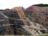
 Two prominent man-made features of Lead's geography are the giant open cut, which was used for surface gold mining by the Homestake Mine, and the resulting ridge nearby built with the non-producing material from the cut.
of 2000, there were 3,027 people, 1,279 households, and 832 families residing in the city. The population density
was 1,521.5 people per square mile (587.3/km²). There were 1,617 housing units at an average density of 812.8 per square mile (313.7/km²). The racial makeup of the city was 95.74% White, 0.23% African American, 2.25% Native American, 0.20% Asian, 0.59% from other races
, and 0.99% from two or more races. Hispanic or Latino of any race were 2.71% of the population. 36.5% were of German
, 8.1% English
, 7.8% Irish
, 7.1% Norwegian and 6.7% American
ancestry according to Census 2000.
There were 1,279 households out of which 33.2% had children under the age of 18 living with them, 47.8% were married couples
living together, 12.4% had a female householder with no husband present, and 34.9% were non-families. 29.2% of all households were made up of individuals and 11.8% had someone living alone who was 65 years of age or older. The average household size was 2.35 and the average family size was 2.89.
In the city the population was spread out with 26.1% under the age of 18, 8.5% from 18 to 24, 30.2% from 25 to 44, 22.2% from 45 to 64, and 13.0% who were 65 years of age or older. The median age was 37 years. For every 100 females there were 100.9 males. For every 100 females age 18 and over, there were 96.8 males.
The median income for a household in the city was $29,485, and the median income for a family was $35,855. Males had a median income of $25,958 versus $18,841 for females. The per capita income
for the city was $15,726. About 10.7% of families and 12.9% of the population were below the poverty line, including 15.7% of those under age 18 and 12.9% of those age 65 or over.
, which runs from Edgemont to Deadwood, runs through the city. Several man made lakes, including Sheridan Lake
provide fishing and swimming. Spearfish Canyon
to the north has many places to rock climb.
During the winter there are two ski areas just a few miles outside of Lead. Terry Peak
and Deer Mountain
are both full service ski areas.
FM radio
Television
Lawrence County, South Dakota
As of the census of 2000, there were 21,802 people, 8,881 households, and 5,559 families residing in the county. The population density was 27 people per square mile . There were 10,427 housing units at an average density of 13 per square mile...
, South Dakota
South Dakota
South Dakota is a state located in the Midwestern region of the United States. It is named after the Lakota and Dakota Sioux American Indian tribes. Once a part of Dakota Territory, South Dakota became a state on November 2, 1889. The state has an area of and an estimated population of just over...
, United States
United States
The United States of America is a federal constitutional republic comprising fifty states and a federal district...
. The population was 3,124 at the 2010 census. Lead is located in western South Dakota
South Dakota
South Dakota is a state located in the Midwestern region of the United States. It is named after the Lakota and Dakota Sioux American Indian tribes. Once a part of Dakota Territory, South Dakota became a state on November 2, 1889. The state has an area of and an estimated population of just over...
, in the Black Hills
Black Hills
The Black Hills are a small, isolated mountain range rising from the Great Plains of North America in western South Dakota and extending into Wyoming, USA. Set off from the main body of the Rocky Mountains, the region is something of a geological anomaly—accurately described as an "island of...
near the Wyoming
Wyoming
Wyoming is a state in the mountain region of the Western United States. The western two thirds of the state is covered mostly with the mountain ranges and rangelands in the foothills of the Eastern Rocky Mountains, while the eastern third of the state is high elevation prairie known as the High...
state line.
History
The city was officially founded on July 10, 1876, after the discovery of goldGold
Gold is a chemical element with the symbol Au and an atomic number of 79. Gold is a dense, soft, shiny, malleable and ductile metal. Pure gold has a bright yellow color and luster traditionally considered attractive, which it maintains without oxidizing in air or water. Chemically, gold is a...
. It is the site of the Homestake Mine
Homestake Mine (South Dakota)
The Homestake Mine was a deep underground gold mine located in Lead, South Dakota. Until it closed in 2002 it was the largest and deepest gold mine in North America, producing more than 40 million ounces of gold. The Homestake Mine is famous in scientific circles for being the site at which the...
, the largest, deepest (8240 feet) and most productive gold mine in the Western Hemisphere
Western Hemisphere
The Western Hemisphere or western hemisphere is mainly used as a geographical term for the half of the Earth that lies west of the Prime Meridian and east of the Antimeridian , the other half being called the Eastern Hemisphere.In this sense, the western hemisphere consists of the western portions...
before closing in January 2002. By 1910 Lead had a population of 8,382, making it the second largest town in South Dakota.
Lead was originally founded as a company town by the Homestake Mining Company
Homestake Mining Company
The Homestake Mining Company was one of the largest gold mining businesses in the United States from the 19th century through the beginning of the 21st...
, which ran the nearby Homestake Mine. Phoebe Hearst
Phoebe Hearst
Phoebe Apperson Hearst was an American philanthropist, feminist and suffragist. She was also the mother of William Randolph Hearst.-Biography:...
, wife of one of the principals, was instrumental in making Lead more livable. She established the Hearst Free Public Library in town, and in 1900 the Hearst Free Kindergarten. Phoebe Hearst and Thomas Grier, the Homestake Mine superintendent worked together to create the Homestake Opera House and Recreation Center for the benefit of miner workers and their families. Phoebe Hearst donated regularly to Lead's churches, and provided college scholarships to the children of mine and mill workers.
In the early 1930s, due to fear of cave ins of the miles of tunnels under Lead's Homestake Mine, many of the towns buildings located in the bottom of a canyon were moved further uphill to safer locations.
Lead and the Homestake Mine have been selected as the site of the Deep Underground Science and Engineering Laboratory
Deep Underground Science and Engineering Laboratory
The Deep Underground Science and Engineering Laboratory, or DUSEL is a major project under consideration by the National Science Foundation. DUSEL will be a series of large laboratories, caverns, and cleanrooms serving the field of underground science...
, a proposed NSF facility for low-background experiments on neutrinos, dark matter, and other nuclear physics topics, as well as biology and mine engineering studies.
In 1974, most of Lead was added to the National Register of Historic Places
National Register of Historic Places
The National Register of Historic Places is the United States government's official list of districts, sites, buildings, structures, and objects deemed worthy of preservation...
under the name of the "Lead Historic District." Over four hundred buildings and 580 acres (234.7 ha) were included in the historic district
Historic district (United States)
In the United States, a historic district is a group of buildings, properties, or sites that have been designated by one of several entities on different levels as historically or architecturally significant. Buildings, structures, objects and sites within a historic district are normally divided...
, which has boundaries roughly equivalent to the city limits.
Geography
Lead is located at 44°21′3"N 103°45′57"W (44.350967, -103.765784).According to the United States Census Bureau
United States Census Bureau
The United States Census Bureau is the government agency that is responsible for the United States Census. It also gathers other national demographic and economic data...
, the city has a total area of 2 square miles (5.2 km²), all of it land.
Lead has been assigned the ZIP code
ZIP Code
ZIP codes are a system of postal codes used by the United States Postal Service since 1963. The term ZIP, an acronym for Zone Improvement Plan, is properly written in capital letters and was chosen to suggest that the mail travels more efficiently, and therefore more quickly, when senders use the...
57754 and the FIPS place code 36220.
Lead's proximity to Deadwood, South Dakota
Deadwood, South Dakota
Deadwood is a city in South Dakota, United States, and the county seat of Lawrence County. It is named for the dead trees found in its gulch. The population was 1,270 according to a 2010 census...
often leads to the two cities being collectively named "Lead-Deadwood".
Demographics
As of the censusCensus
A census is the procedure of systematically acquiring and recording information about the members of a given population. It is a regularly occurring and official count of a particular population. The term is used mostly in connection with national population and housing censuses; other common...
of 2000, there were 3,027 people, 1,279 households, and 832 families residing in the city. The population density
Population density
Population density is a measurement of population per unit area or unit volume. It is frequently applied to living organisms, and particularly to humans...
was 1,521.5 people per square mile (587.3/km²). There were 1,617 housing units at an average density of 812.8 per square mile (313.7/km²). The racial makeup of the city was 95.74% White, 0.23% African American, 2.25% Native American, 0.20% Asian, 0.59% from other races
Race (United States Census)
Race and ethnicity in the United States Census, as defined by the Federal Office of Management and Budget and the United States Census Bureau, are self-identification data items in which residents choose the race or races with which they most closely identify, and indicate whether or not they are...
, and 0.99% from two or more races. Hispanic or Latino of any race were 2.71% of the population. 36.5% were of German
Germans
The Germans are a Germanic ethnic group native to Central Europe. The English term Germans has referred to the German-speaking population of the Holy Roman Empire since the Late Middle Ages....
, 8.1% English
English people
The English are a nation and ethnic group native to England, who speak English. The English identity is of early mediaeval origin, when they were known in Old English as the Anglecynn. England is now a country of the United Kingdom, and the majority of English people in England are British Citizens...
, 7.8% Irish
Irish people
The Irish people are an ethnic group who originate in Ireland, an island in northwestern Europe. Ireland has been populated for around 9,000 years , with the Irish people's earliest ancestors recorded having legends of being descended from groups such as the Nemedians, Fomorians, Fir Bolg, Tuatha...
, 7.1% Norwegian and 6.7% American
United States
The United States of America is a federal constitutional republic comprising fifty states and a federal district...
ancestry according to Census 2000.
There were 1,279 households out of which 33.2% had children under the age of 18 living with them, 47.8% were married couples
Marriage
Marriage is a social union or legal contract between people that creates kinship. It is an institution in which interpersonal relationships, usually intimate and sexual, are acknowledged in a variety of ways, depending on the culture or subculture in which it is found...
living together, 12.4% had a female householder with no husband present, and 34.9% were non-families. 29.2% of all households were made up of individuals and 11.8% had someone living alone who was 65 years of age or older. The average household size was 2.35 and the average family size was 2.89.
In the city the population was spread out with 26.1% under the age of 18, 8.5% from 18 to 24, 30.2% from 25 to 44, 22.2% from 45 to 64, and 13.0% who were 65 years of age or older. The median age was 37 years. For every 100 females there were 100.9 males. For every 100 females age 18 and over, there were 96.8 males.
The median income for a household in the city was $29,485, and the median income for a family was $35,855. Males had a median income of $25,958 versus $18,841 for females. The per capita income
Per capita income
Per capita income or income per person is a measure of mean income within an economic aggregate, such as a country or city. It is calculated by taking a measure of all sources of income in the aggregate and dividing it by the total population...
for the city was $15,726. About 10.7% of families and 12.9% of the population were below the poverty line, including 15.7% of those under age 18 and 12.9% of those age 65 or over.
Recreation
In the summer, there are numerous trails for hiking, mountain biking, and horse back riding. The George S. Mickelson TrailGeorge S. Mickelson Trail
The George S. Mickelson Trail is a rail trail in the Black Hills region of South Dakota.The main trail route extends , from Edgemont to Deadwood, with approximately nine miles of additional branch trails, including a three mile paved link from Custer to the Custer State Park completed in 2007...
, which runs from Edgemont to Deadwood, runs through the city. Several man made lakes, including Sheridan Lake
Sheridan Lake
Sheridan Lake, a reservoir, is located on Spring Creek in Pennington County, South Dakota. Built over the site of Sheridan, the first county seat, it is owned and operated by the U S Forest Service, and is one of the recreational areas of Black Hills National Forest.Facilities include a marina,...
provide fishing and swimming. Spearfish Canyon
Spearfish Canyon
Spearfish Canyon is a deep but narrow gorge carved by Spearfish Creek just south of Spearfish, South Dakota in the U.S. It is located on the northern edge of Black Hills National Forest. Many tourists drive through the canyon, drawn to the region due to its wide range of plant and wildlife,...
to the north has many places to rock climb.
During the winter there are two ski areas just a few miles outside of Lead. Terry Peak
Terry Peak
Terry Peak is a mountain and ski area in the Black Hills outside of Lead, South Dakota, USA. It is the third highest point east of the Rockies in the continental United States. Terry Peak was first used as a ski area in 1936 by the Bald Mountain Ski Club when a rope tow was installed...
and Deer Mountain
Deer Mountain
Mystic Miner Ski Resort is a ski resort, in the Black Hills, just outside of Lead, South Dakota, in the United States. Deer Mountain has a vertical drop of 699 feet. The summit of Deer Mountain is at 6,850 feet.-Ski Area Description:*44 runs*3 lifts...
are both full service ski areas.
Local media
AM radio- KBHBKBHBKBHB is a radio station broadcasting a farm/news related format. Licensed to Sturgis, South Dakota, USA, it serves the Rapid City area. The station is currently owned by New Rushmore Radio, Inc...
810 - KKLSKKLS (AM)KKLS is a radio station licensed to serve Rapid City, South Dakota. The station is owned by New Rushmore Radio, Inc. It airs an Oldies music format...
920 - KDSJKDSJKDSJ is a radio station broadcasting an oldies format. Licensed to Deadwood, South Dakota, USA, the station serves the Rapid City area. The station is currently owned by Goldrush Broadcasting, Inc....
980 - KTOQKTOQKTOQ is a radio station broadcasting a news/talk format. Licensed to Rapid City, South Dakota, USA, the station serves the Rapid City area...
1340 - KBFSKBFSKBFS is a radio station broadcasting a News Talk Information format. Licensed to Belle Fourche, South Dakota, USA, the station serves the Rapid City area. The station is currently owned by Ultimate Caps, Inc...
1450
FM radio
- KRCSKRCSKRCS is a radio station that airs a Top 40 format in the Rapid City and the Black Hills area. The station is owned by New Rushmore Radio, Inc...
93.1 - KKMKKKMKKKMK is a radio station in Rapid City, South Dakota, airing a hot adult contemporary format.-Ownership:In May 1999, Triad Broadcasting reached a deal to acquire this station from Brothers Jim and Tom Instad as part of a twelve-station deal valued at a reported $37.8 million.In July 2006, Schurz...
93.9 - KSQYKSQYKSQY is a radio station broadcasting a mainstream rock format. The station known as "K-SKY" is licensed to Deadwood, South Dakota and serves the Rapid City listening area...
95.1 - KZZIKZZIKZZI is a radio station licensed to serve Belle Fourche, South Dakota, serving the Rapid City, South Dakota market. The station is owned by Duhamel Broadcasting and licensed to Western South Dakota Broadcasting, LLC...
95.9 - KOUTKOUTKOUT is a radio station licensed to serve Rapid City, South Dakota. The station is owned by New Rushmore Radio, Inc. It airs a country music format....
98.7 - KFXSKFXSKFXS is a radio station licensed to serve Rapid City, South Dakota. The station is owned by New Rushmore Radio, Inc...
100.3 - KDDXKDDX-External links:*...
101.1 - KFMHKFMH-External links:*...
101.9 - KYDTKYDTKYDT is a radio station broadcasting a News Talk Information format. Licensed to Pine Haven, Wyoming, USA, and serves the Sundance, Wyoming and Belle Fourche, South Dakota region of the Black Hills. It is currently owned by Ultimate Caps, Inc. and features programing from ESPN Radio, Jones Radio...
103.1 - KIQKKIQKKIQK is a radio station broadcasting a Country music format. Licensed to Rapid City, South Dakota, USA, the station serves the Rapid City area. The station is currently owned by Haugo Broadcasting, Inc.-History:...
104.1
Television
- KOTA-TVKOTA-TVKOTA-TV, channel 3, is an ABC television affiliate based in Rapid City, South Dakota, USA. The station is owned by the Duhamel family of Rapid City...
Ch. 3 ABCAmerican Broadcasting CompanyThe American Broadcasting Company is an American commercial broadcasting television network. Created in 1943 from the former NBC Blue radio network, ABC is owned by The Walt Disney Company and is part of Disney-ABC Television Group. Its first broadcast on television was in 1948... - KCLO Ch. 16 CBSCBSCBS Broadcasting Inc. is a major US commercial broadcasting television network, which started as a radio network. The name is derived from the initials of the network's former name, Columbia Broadcasting System. The network is sometimes referred to as the "Eye Network" in reference to the shape of...
- KNBNKNBNKNBN, channel 21, is the NBC affiliate in Rapid City, South Dakota. It is owned by Rapid Broadcasting, and is also the sister station to KWBH-LP...
Ch. 21 NBCNBCThe National Broadcasting Company is an American commercial broadcasting television network and former radio network headquartered in the GE Building in New York City's Rockefeller Center with additional major offices near Los Angeles and in Chicago... - KBHE-TV Ch. 26 PBSPublic Broadcasting ServiceThe Public Broadcasting Service is an American non-profit public broadcasting television network with 354 member TV stations in the United States which hold collective ownership. Its headquarters is in Arlington, Virginia....
Notable natives
- Mike SteponovichMike SteponovichMichael M. Steponovich was an American football end in the National Football League for the Boston Redskins. He attended Saint Mary's College of California....
(1908–1974), former American NFL football player with the Boston Redskins - Sean CovelSean CovelSean Covel is an American film producer.-Personal life:Covel graduated from the University of Southern California School of Cinematic Arts in 2002.He married actress Alexa Vega on October 10, 2010.-Career:...
(b. 1976), American film producer