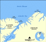
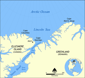
Lincoln Sea is a body of water in the
Arctic OceanThe Arctic Ocean, located in the Northern Hemisphere and mostly in the Arctic north polar region, is the smallest and shallowest of the world's five major oceanic divisions...
, stretching from
Cape ColumbiaCape Columbia is the northernmost point of land of Canada, located on Ellesmere Island in the Qikiqtaaluk Region of Nunavut. It marks the westernmost coastal point of Lincoln Sea in the Arctic Ocean...
,
CanadaCanada is a North American country consisting of ten provinces and three territories. Located in the northern part of the continent, it extends from the Atlantic Ocean in the east to the Pacific Ocean in the west, and northward into the Arctic Ocean...
, in the west to
Cape Morris JesupCape Morris Jesup is the northernmost point of mainland Greenland at and is 711.8 km from the geographic North Pole...
,
GreenlandGreenland is an autonomous country within the Kingdom of Denmark, located between the Arctic and Atlantic Oceans, east of the Canadian Arctic Archipelago. Though physiographically a part of the continent of North America, Greenland has been politically and culturally associated with Europe for...
, in the east. The northern limit is defined as the
great circleA great circle, also known as a Riemannian circle, of a sphere is the intersection of the sphere and a plane which passes through the center point of the sphere, as opposed to a general circle of a sphere where the plane is not required to pass through the center...
line between those two
headlandA headland is a point of land, usually high and often with a sheer drop, that extends out into a body of water.Headland can also refer to:*Headlands and bays*headLand, an Australian television series...
s. It is covered with
sea iceSea ice is largely formed from seawater that freezes. Because the oceans consist of saltwater, this occurs below the freezing point of pure water, at about -1.8 °C ....
throughout the year, the thickest sea ice in the Arctic Ocean, which can be up to 15 m (49.2 ft) thick. Water depths range from 100 m (328.1 ft) to 300 m (984.3 ft). Water and ice from Lincoln Sea empty into
Robeson ChannelRobeson Channel is a body of water lying between Greenland and Canada's northernmost island, Ellesmere Island. It is the most northerly part of Nares Strait, linking Hall Basin to the south with the Arctic Ocean to the north....
, the northernmost part of
Nares StraitNares Strait is a waterway between Ellesmere Island and Greenland that is the northern part of Baffin Bay where it meets the Lincoln Sea. From south to north, the strait includes Smith Sound, Kane Basin, Kennedy Channel, Hall Basin and Robeson Channel...
, most of the time.
The sea was named after
Robert Todd LincolnRobert Todd Lincoln was an American lawyer and Secretary of War, and the first son of President Abraham Lincoln and Mary Todd Lincoln...
, then
United States Secretary of WarThe Secretary of War was a member of the United States President's Cabinet, beginning with George Washington's administration. A similar position, called either "Secretary at War" or "Secretary of War," was appointed to serve the Congress of the Confederation under the Articles of Confederation...
, on Adolphus W. Greely's 1881–1884 Arctic expedition into
Lady Franklin BayLady Franklin Bay is an Arctic waterway in Qikiqtaaluk Region, Nunavut, Canada. The bay is located in Nares Strait and is an inlet into the northeastern shore of Ellesmere Island....
.
AlertAlert, in the Qikiqtaaluk Region, Nunavut, Canada, is the northernmost permanently inhabited place in the world, from the North Pole. It takes its name from HMS Alert, which wintered east of the present station, off what is now Cape Sheridan, in 1875–1876.Alert was reported to have five permanent...
, the northernmost station of Canada, is the only populated place on the shore of Lincoln Sea.
The body of water to the east of Lincoln Sea (east of Cape Morris Jesup) is
Wandel SeaThe Wandel Sea is a body of water in the Arctic Ocean, stretching from northeast of Greenland to Svalbard. This arctic sea is located at 82° north longitude and 21° west latitude. Seas farther north and northwest of the Wandel Sea are frozen year-round. The Wandel Sea stretches as far west as Cape...
.
Extent
The
International Hydrographic OrganizationThe International Hydrographic Organization is the inter-governmental organisation representing the hydrographic community. It enjoys observer status at the UN and is the recognised competent authority on hydrographic surveying and nautical charting...
defines the limits of the Lincoln Sea as follows:
On the North. Cape ColumbiaCape Columbia is the northernmost point of land of Canada, located on Ellesmere Island in the Qikiqtaaluk Region of Nunavut. It marks the westernmost coastal point of Lincoln Sea in the Arctic Ocean...
to Cape Morris JesupCape Morris Jesup is the northernmost point of mainland Greenland at and is 711.8 km from the geographic North Pole...
(GreenlandGreenland is an autonomous country within the Kingdom of Denmark, located between the Arctic and Atlantic Oceans, east of the Canadian Arctic Archipelago. Though physiographically a part of the continent of North America, Greenland has been politically and culturally associated with Europe for...
).
On the South. Cape Columbia through Northeastern shore of Ellesmere IslandEllesmere Island is part of the Qikiqtaaluk Region of the Canadian territory of Nunavut. Lying within the Canadian Arctic Archipelago, it is considered part of the Queen Elizabeth Islands, with Cape Columbia being the most northerly point of land in Canada...
to Cape SheridanCape Sheridan is on the northeastern coast of Ellesmere Island, Canada situated on the Lincoln Sea in the Arctic Ocean, on the mouth of Sheridan River, west bank...
to Cape BryantCape Bryant is on the northern coast of Greenland, marking the northeastern extent of the Robeson Channel where it joins the Lincoln Sea in the Arctic Ocean, at ....
(Greenland) through Greenland to Cape Morris Jesup.
The source of this article is
wikipedia, the free encyclopedia. The text of this article is licensed under the
GFDL.