

List of highways in Warren County, New York
Encyclopedia
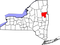
Warren County, New York
Warren County is a county in the U.S. state of New York. It is part of the Glens Falls, New York, Metropolitan Statistical Area. As of the 2010 census, the population was 65,707. It is named in honor of General Joseph Warren, an American Revolutionary War hero of the Battle of Bunker Hill...
, consists of roads maintained by the state of New York
New York
New York is a state in the Northeastern region of the United States. It is the nation's third most populous state. New York is bordered by New Jersey and Pennsylvania to the south, and by Connecticut, Massachusetts and Vermont to the east...
(through the New York State Department of Transportation
New York State Department of Transportation
The New York State Department of Transportation is responsible for the development and operation of highways, railroads, mass transit systems, ports, waterways and aviation facilities in the U.S...
or NYSDOT), the county, and its towns and villages. The county and state-maintained roads account for about 470 miles (756.4 km) of the highway system in New York
New York
New York is a state in the Northeastern region of the United States. It is the nation's third most populous state. New York is bordered by New Jersey and Pennsylvania to the south, and by Connecticut, Massachusetts and Vermont to the east...
. Most roads within the county are short connectors, while others are sections of 30 miles (48.3 km) long highways. There is one Interstate Highway in Warren County, Interstate 87 (I-87), also known as the Adirondack Northway. There is one U.S. Highway, U.S. Route 9 (US 9), and eight state-numbered signed touring routes in the county, the longest being New York State Route 9N (NY 9N). There are three other state-maintained reference routes in the county, the longest being NY 917A, commonly known as the Prospect Mountain Veterans Memorial Highway
Prospect Mountain Veterans Memorial Highway
The Prospect Mountain Veterans Memorial Highway is a parkway located in the town of Lake George, New York. The road is long, starting at the U.S. Route 9 and New York State Route 9N concurrency and ending at the peak of Prospect Mountain...
. Additionally, there are 81 county-maintained routes, most of which are short connectors between more major roads.
The longest state route within the county is NY 9N, which spans 48.58 miles (78.18 km) in the county alone. The shortest state-maintained route is NY 911E, a 0.2 mile (0.321868 km) reference route. These roads supply some of the major municipalities in Warren County, including the city of Glens Falls
Glens Falls, New York
Glens Falls is a city in Warren County, New York, United States. Glens Falls Metropolitan Statistical Area. The population was 14,700 at the 2010 census...
, the towns of Warrensburg
Warrensburg (town), New York
Warrensburg is a town in Warren County, New York, USA. It is centrally located in the county, west of Lake George. It is part of the Glens Falls Metropolitan Statistical Area. The town population was 4,255 at the 2000 census. Like the county, the town is named after General Joseph Warren. U.S....
and Queensbury
Queensbury, New York
Queensbury is a town in and the county seat of Warren County, New York, United States. The town is located in the southeastern part of the county. The population was 25,441 at the 2000 census. The town is named in honor of Queen Charlotte, the consort of George III of Great Britain and Ireland. It...
, along with the village of Lake George
Lake George (village), New York
The Village of Lake George is a village within the town of Lake George in Warren County, New York, United States. The population was 985 at the 2000 census. It is part of the Glens Falls Metropolitan Statistical Area...
.
Interstate and U.S. Highways
I-87Interstate 87
Interstate 87 is a Interstate Highway located entirely within New York State in the United States of America. I-87 is the longest intrastate Interstate highway in the Interstate Highway System. Its southern end is at the Bronx approaches of the Robert F. Kennedy Bridge in New York City...
is the only Interstate Highway that enters Warren County. It travels for 38.53 miles (62 km) within the county and has nine interchange
Interchange (road)
In the field of road transport, an interchange is a road junction that typically uses grade separation, and one or more ramps, to permit traffic on at least one highway to pass through the junction without directly crossing any other traffic stream. It differs from a standard intersection, at which...
s along the way. Exits off the highway serve Glens Falls
Glens Falls, New York
Glens Falls is a city in Warren County, New York, United States. Glens Falls Metropolitan Statistical Area. The population was 14,700 at the 2010 census...
, Queensbury
Queensbury, New York
Queensbury is a town in and the county seat of Warren County, New York, United States. The town is located in the southeastern part of the county. The population was 25,441 at the 2000 census. The town is named in honor of Queen Charlotte, the consort of George III of Great Britain and Ireland. It...
, Warrensburg
Warrensburg (town), New York
Warrensburg is a town in Warren County, New York, USA. It is centrally located in the county, west of Lake George. It is part of the Glens Falls Metropolitan Statistical Area. The town population was 4,255 at the 2000 census. Like the county, the town is named after General Joseph Warren. U.S....
, Lake George
Lake George (town), New York
Lake George is a town in Warren County, New York, USA. The population was 3,578 at the 2000 census. The town is named after the lake, Lake George. Within the town is a village also named Lake George. The town is part of the Glens Falls Metropolitan Statistical Area.- History :The lake was...
, Bolton Landing
Bolton Landing, New York
Bolton Landing is a hamlet in the town of Bolton in Warren County, New York, United States. It is located on Lake George in the Adirondack Mountains. It is a common tourist destination and the closest town to the State Park lands and islands of the Lake George Narrows...
, and Chestertown
Chestertown, New York
Chestertown is a hamlet in Warren County, New York, United States, in the Adirondack Mountains, in the Town of Chester. The population was 2,187 at the 2000 census. The community is located by the junction of Route 8 and U.S. Route 9....
. The highway once terminated in downtown Lake George, with its former two-lane
Two-lane freeway
A two-lane expressway is an expressway with only one lane in each direction, and usually no median barrier. It may be built that way because of constraints, or may be intended for expansion once traffic volumes rise. The term super two is often used by roadgeeks for this type of road, but traffic...
end becoming NY 912Q after the highway was extended northward.
There have been two U.S. Highways in Warren County. The longest—and the only current one—is US 9, which spans for over 40.43 miles (65.1 km) within the county. Since its designation in 1926, US 9 services the city of Glens Falls, Queensbury, the village of Lake George, Warrensburg and Chestertown before leaving for Essex County
Essex County, New York
Essex County is a county located in the U.S. state of New York. As of the 2010 census, the population was 39,370. Its name is from the English county of Essex. Its county seat is Elizabethtown...
. US 9 once had four suffixed routes in the county; however, only two still exist. Also assigned in 1926 was US 4
U.S. Route 4 in New York
U.S. Route 4 is a part of the U.S. Highway System that runs from East Greenbush, New York, to Portsmouth, New Hampshire. In the U.S. state of New York, US 4 extends from an intersection with US 9 and US 20 in East Greenbush to the Vermont state line northeast of Whitehall...
, which initially terminated in Glens Falls at US 9. It was realigned as part of the 1930 renumbering of state highways in New York to follow the Hudson River
Hudson River
The Hudson is a river that flows from north to south through eastern New York. The highest official source is at Lake Tear of the Clouds, on the slopes of Mount Marcy in the Adirondack Mountains. The river itself officially begins in Henderson Lake in Newcomb, New York...
south from Hudson Falls
Hudson Falls, New York
Hudson Falls is a village located in Washington County, New York, USA. The village is in the southwest part of the town of Kingsbury, on US Route 4. Hudson Falls is part of the Glens Falls Metropolitan Statistical Area. As of the 2000 census, the village had a population of 6,927...
to the Capital District
Capital District
New York's Capital District, also known as the Capital Region, is a region in upstate New York that generally refers to the four counties surrounding Albany, the capital of the state: Albany County, Schenectady County, Rensselaer County, and Saratoga County...
, bypassing Warren County to the east.
State touring routes and scenic byways
Touring routes are signed with black and white route markers, and small, green reference markerReference marker (New York)
In New York, a reference marker is a small green sign mounted approximately every one-tenth mile on highways maintained by the New York State Department of Transportation. This was initiated in response to the Highway Safety Act of 1966 enacted by Congress, in an effort to monitor traffic and...
s are posted along the state-maintained sections of the routes. There have been 18 state signed touring routes in Warren County since the modern state touring system was established in 1924; however, only 10 of them remain. Three routes created in 1924—NY 6, NY 10
New York State Route 10
New York State Route 10 is a north–south state highway in the Central New York and North Country regions of New York in the United States. It extends for from the Quickway in Deposit, Delaware County to NY 8 at Higgins Bay, a hamlet in the Hamilton County town of Arietta...
, and NY 30—entered the Warren County limits, crossing the county in a north–south manner. Another route, NY 47, was assigned by 1926 to an alignment extending from Chestertown
Chestertown, New York
Chestertown is a hamlet in Warren County, New York, United States, in the Adirondack Mountains, in the Town of Chester. The population was 2,187 at the 2000 census. The community is located by the junction of Route 8 and U.S. Route 9....
to Ticonderoga via Hague
Hague, New York
Hague is a town in northeastern Warren County, New York, United States located on the scenic Lake George. It is part of the Glens Falls Metropolitan Statistical Area. The population was 854 at the 2000 census...
. NY 6 was replaced by US 9 in 1927, and the three other routes were realigned out of the county or eliminated entirely as part of the 1930 renumbering.
The post-renumbering state route system in Warren County was identical to the current route layout, save for a handful of routes. In the 1930 renumbering, NY 9K was assigned to NY 10's former routing between Saratoga Springs
Saratoga Springs, New York
Saratoga Springs, also known as simply Saratoga, is a city in Saratoga County, New York, United States. The population was 26,586 at the 2010 census. The name reflects the presence of mineral springs in the area. While the word "Saratoga" is known to be a corruption of a Native American name, ...
and Lake George
Lake George (village), New York
The Village of Lake George is a village within the town of Lake George in Warren County, New York, United States. The population was 985 at the 2000 census. It is part of the Glens Falls Metropolitan Statistical Area...
while NY 47 was reassigned to a highway between Lake George village and Hague that ran along the western shore of Lake George
Lake George (New York)
Lake George, nicknamed the Queen of American Lakes, is a long, narrow oligotrophic lake draining northwards into Lake Champlain and the St. Lawrence River Drainage basin located at the southeast base of the Adirondack Mountains in northern New York, U.S.A.. It lies within the upper region of the...
. NY 9N
New York State Route 9N
New York State Route 9N is a north–south state highway in northeastern New York, United States. It extends from an intersection with U.S. Route 9 , NY 29, and NY 50 in the city of Saratoga Springs to a junction with US 9 and NY 22 in the Clinton County village of...
, meanwhile, initially began in Elizabethtown
Elizabethtown (hamlet), New York
Elizabethtown is a hamlet in the town of Elizabethtown in Essex County, New York, United States. Many locals in the town, as well as those who surround the area call Elizabethtown, E-Town....
, Essex County
Essex County, New York
Essex County is a county located in the U.S. state of New York. As of the 2010 census, the population was 39,370. Its name is from the English county of Essex. Its county seat is Elizabethtown...
. That route was extended south twice: first to Lake George ca. 1936, replacing NY 47; and again to Saratoga Springs in the early 1950s, supplanting NY 9K. Also assigned in the renumbering was NY 32B
New York State Route 32B
New York State Route 32B was a state highway in the Capital District region of New York, United States. The western terminus of the route was at an intersection with NY 32 in Queensbury. Its eastern terminus was at a junction with U.S. Route 4 in Hudson Falls...
, an alternate route of NY 32
New York State Route 32
New York State Route 32 is a north–south state highway that extends for through the Hudson Valley and Capital District regions of the U.S. state of New York. It is a two-lane surface road for nearly its entire length, with few divided and no limited-access sections. From Harriman to Albany,...
that began in Glens Falls and followed the Hudson River
Hudson River
The Hudson is a river that flows from north to south through eastern New York. The highest official source is at Lake Tear of the Clouds, on the slopes of Mount Marcy in the Adirondack Mountains. The river itself officially begins in Henderson Lake in Newcomb, New York...
east into Washington County
Washington County, New York
Washington County is a county located in the U.S. state of New York. It is part of the Glens Falls, New York, Metropolitan Statistical Area. As of the 2010 census, the population was 63,216. It was named for the Revolutionary War general George Washington...
. NY 9M, a north–south spur connecting US 9 to NY 8, was assigned by the following year, but eliminated ca. 1939.
By 1940, NY 32 was extended into Warren County, passing through Glens Falls and Queensbury on its way to a terminus in Washington County. NY 32B initially overlapped with NY 32 along Warren Street; however, it was truncated eastward to begin in Queensbury ca. 1962 and eliminated ca. 1965. It was partially replaced by NY 254
New York State Route 254
New York State Route 254 is a state highway that extends for through Warren and Washington Counties in the Capital District of New York, United States...
, a northeasterly bypass of Glens Falls from I-87 to Washington County.
Of the 10 current routes, NY 418
New York State Route 418
New York State Route 418 is a state highway located entirely within the Adirondack Park in Warren County, New York, United States. The route begins just west of the hamlet of Thurman Station, where Athol Road changes designations from County Route 4 to NY 418...
in Warrensburg is the shortest while NY 9N is the longest. Other active routes in Warren County include NY 8
New York State Route 8
New York State Route 8 is a state highway in the central part of New York in the United States. It runs in a southwest-to-northeast direction from the Southern Tier to the northern part of Lake George. The southern terminus of the route is at an interchange with NY 17 in the town of...
, which spans the northern part of the county; NY 9L
New York State Route 9L
New York State Route 9L is a state highway in Warren County, New York, in the United States. The road is long and is a suffixed highway of U.S. Route 9 . NY 9L goes through three municipalities in Warren County: the city of Glens Falls, the town of Queensbury and the town of Lake...
, a short suffixed route of US 9; NY 149
New York State Route 149
New York State Route 149 is an east–west state highway that runs for through the Capital District of New York in the United States. It begins at exit 20 on the Adirondack Northway in the Warren County town of Queensbury and intersects U.S...
, a connector from I-87 to the Vermont border in Warren and nearby Washington Counties; NY 28
New York State Route 28
New York State Route 28 is a state highway extending for in the shape of a "C" between the Hudson Valley city of Kingston and southern Warren County in the U.S. state of New York. Along the way, it intersects several major routes, including Interstate 88 , U.S. Route 20 , and the...
, which serves western Warren County and terminates in Johnsburg
Johnsburg, New York
Johnsburg is a town in the northwest corner of Warren County, New York, United States. It is part of the Glens Falls Metropolitan Statistical Area. The town population was 2,450 at the 2000 census. The town is named after John Thurman, an early settler and founder. Johnsburg is the largest town in...
; and its suffixed route, NY 28N
New York State Route 28N
New York State Route 28N is a state highway in the Adirondacks in New York that extends from Blue Mountain Lake to North Creek. The route, in length, is a northerly alternate route to NY 28 between both locations. The highway passes through several communities before terminating at...
, which ends in the western part of the county.
There are 13 New York State Scenic Byways in the Adirondacks alone, three of them in Warren County. The first is the Roosevelt–Marcy Trail, which runs on NY 28N
New York State Route 28N
New York State Route 28N is a state highway in the Adirondacks in New York that extends from Blue Mountain Lake to North Creek. The route, in length, is a northerly alternate route to NY 28 between both locations. The highway passes through several communities before terminating at...
. The second is the Dude Ranch Trail, a loop
Loop route
A loop route is a highway or other major road that extends out from a typically longer, more important parents road to enter and circle a large city. A loop can function as a bypass for through traffic and also to service outlying suburbs....
in Warren and nearby Saratoga
Saratoga County, New York
Saratoga County is a county located in the U.S. state of New York. As of the 2010 census, the population was 219,607. It is part of the Albany-Schenectady-Troy Metropolitan Statistical Area. The county seat is Ballston Spa...
counties, and the third is the Central Adirondack Trail, which utilizes parts of NY 9L
New York State Route 9L
New York State Route 9L is a state highway in Warren County, New York, in the United States. The road is long and is a suffixed highway of U.S. Route 9 . NY 9L goes through three municipalities in Warren County: the city of Glens Falls, the town of Queensbury and the town of Lake...
, US 9 and NY 28
New York State Route 28
New York State Route 28 is a state highway extending for in the shape of a "C" between the Hudson Valley city of Kingston and southern Warren County in the U.S. state of New York. Along the way, it intersects several major routes, including Interstate 88 , U.S. Route 20 , and the...
.
State reference routes
There are three state-maintained reference routes in Warren County. A reference route is a road owned by the state but are signed only with reference markers. The shortest of these is NY 911E, an east–west highway connecting NY 32 to NY 254. The route is the only portion of NY 32B's former alignment in Warren County that did not become part of NY 254. Although it is the shortest reference route in the county, the New York State Department of TransportationNew York State Department of Transportation
The New York State Department of Transportation is responsible for the development and operation of highways, railroads, mass transit systems, ports, waterways and aviation facilities in the U.S...
has reserved NY 656, a replacement touring route designation, for the highway. A date for the renumbering has not been determined. The longest of Warren County's three reference routes is NY 917A, better known as the Prospect Mountain Veterans Memorial Highway
Prospect Mountain Veterans Memorial Highway
The Prospect Mountain Veterans Memorial Highway is a parkway located in the town of Lake George, New York. The road is long, starting at the U.S. Route 9 and New York State Route 9N concurrency and ending at the peak of Prospect Mountain...
. The final reference route is NY 912Q, a two lane freeway spur leading east from I-87 exit 22.
County-maintained roads
There are 81 county-maintained roads in Warren County. Most are short connectors between major roadways, although a few are former state roads. A few examples are CR 64 and CR 62, both of which were part of NY 9M during the 1930s, and CR 79, which was part of NY 32New York State Route 32
New York State Route 32 is a north–south state highway that extends for through the Hudson Valley and Capital District regions of the U.S. state of New York. It is a two-lane surface road for nearly its entire length, with few divided and no limited-access sections. From Harriman to Albany,...
until 1981. In some cases, a single county route designation has been assigned to several different highways. An example is CR 11, which begins at an intersection with CR 10 just east of the Northway (I-87) in Chestertown, but splits into two east of Riverbank. Until 2009, Warren County Routes were not signed like normal touring routes; instead, they were marked with tab–like signs mounted on the back of poles. There was one exception, as CR 23 was signed as a normal county route would.
In November 2007, locals of Warren County produced concern that the salt used on several county highways including CR 7, CR 11, and CR 35 was starting to harm the fragile environment of Lake George
Lake George (New York)
Lake George, nicknamed the Queen of American Lakes, is a long, narrow oligotrophic lake draining northwards into Lake Champlain and the St. Lawrence River Drainage basin located at the southeast base of the Adirondack Mountains in northern New York, U.S.A.. It lies within the upper region of the...
and the surrounding area. The Warren County Highway Department uses an average of 9000 short tons (8,036 LT) of salt on the roads around the Lake George area annually. The salt is beginning to flow into the lake, causing a harmful environmental impact. Since the amount of salt in Lake George has doubled since the 1980s, the highway department switched from using sand entirely to using salt for safety of drivers, rather than the environment. Local officials recognize the problem at hand and are trying to find ways to minimize salt usage.
In late 2009, Warren County DPW began adding the Manual on Uniform Traffic Control Devices
Manual on Uniform Traffic Control Devices
The Manual on Uniform Traffic Control Devices is a document issued by the Federal Highway Administration of the United States Department of Transportation to specify the standards by which traffic signs, road surface markings, and signals are designed, installed, and used...
-standard pentagon shield to their county roads. Signage is generally limited to the terminus of a single road, and roads are not signed at intersections with other county or state roads or when numbers change. One example of the latter is CR 32 (Call Street) and CR 28 (Corinth Road), where the only visible shield heading east is for CR 32 at CR 16 (East River Drive).
Interstate, U.S., and state highways
The chart below shows current Interstate, U.S., and state highways by year of creation, length, and towns crossed. "Formed" displays the year or time period in which the route was assigned; "Length" shows the highway's total length in Warren County.| Route | Formed | Length | Towns crossed | |
|---|---|---|---|---|
| mi | km | |||
| 1957 |
Queensbury, Lake George, Warrensburg, Chester | |||
| 1926 |
Glens Falls, Queensbury, Lake George, Warrensburg, Chester | |||
| 1930 |
Chester, Johnsburg | |||
| 1930 |
Queensbury, Lake George | |||
| 1930 |
Lake Luzerne, Lake George, Bolton, Hague | |||
| 1930 |
Chester, Warrensburg | |||
| 1930 |
North Creek | |||
| 1930 |
Glens Falls, Queensbury | |||
| 1930 |
Queensbury | |||
| ca. 1965 |
Queensbury | |||
| 1930 |
Warrensburg | |||
| NY 911E | — |
Queensbury | ||
| NY 912Q | 1967 |
Lake George | ||
 Prospect Mountain Veterans Memorial Highway The Prospect Mountain Veterans Memorial Highway is a parkway located in the town of Lake George, New York. The road is long, starting at the U.S. Route 9 and New York State Route 9N concurrency and ending at the peak of Prospect Mountain... |
1969 |
Lake George | ||
County Routes
The chart below covers the county routes in Warren County. The county route system was established by 1991.| Route | Length | From | Via | To | Notes | |
|---|---|---|---|---|---|---|
| mi | km | |||||
| CR 1 | 0.9 miles (1.4 km) south of NY 8 | Riverside Station Road in Johnsburg Johnsburg, New York Johnsburg is a town in the northwest corner of Warren County, New York, United States. It is part of the Glens Falls Metropolitan Statistical Area. The town population was 2,450 at the 2000 census. The town is named after John Thurman, an early settler and founder. Johnsburg is the largest town in... |
NY 8 | Former number; now town-maintained | ||
| CR 2 |
CR 3 at Stony Creek Stony Creek, New York Stony Creek is a town in the southwest part of Warren County, New York, United States. It is northwest of the city of Glens Falls and is part of the Glens Falls Metropolitan Statistical Area. The population was 743 at the 2000 census. The town is named for a stream that flows through it... town line |
Stony Creek Road in Thurman Thurman, New York Thurman is a town in the western part of Warren County, New York, United States. It is part of the Glens Falls Metropolitan Statistical Area. The town population was 1,199 at the 2000 census. The town is named after John Thurman, an early landowner... |
CR 4 | |||
| CR 3 |
Becomes CR 22 0.27 mile (0.4345218 km) north of CR 76 | Harrisburg and Warrensburg Roads in Stony Creek | CR 2 at Thurman town line | |||
 CR 4 CR 4 |
NY 418 | Stony Creek and Athol Roads, High Street, Mountain and Valley Roads in Thurman | CR 57 at Garnet Lake Road | |||
| CR 5 |
CR 9 | Fourth Avenue in Warrensburg Warrensburg (town), New York Warrensburg is a town in Warren County, New York, USA. It is centrally located in the county, west of Lake George. It is part of the Glens Falls Metropolitan Statistical Area. The town population was 4,255 at the 2000 census. Like the county, the town is named after General Joseph Warren. U.S.... |
US 9 | |||
| CR 6 |
US 9 | Fort George Road in Lake George Lake George (town), New York Lake George is a town in Warren County, New York, USA. The population was 3,578 at the 2000 census. The town is named after the lake, Lake George. Within the town is a village also named Lake George. The town is part of the Glens Falls Metropolitan Statistical Area.- History :The lake was... |
CR 51 | |||
| Lake George Beach State Park | Beach Road in Lake George | NY 9L | ||||
 CR 7 CR 7 |
Glens Falls Glens Falls, New York Glens Falls is a city in Warren County, New York, United States. Glens Falls Metropolitan Statistical Area. The population was 14,700 at the 2010 census... city line |
Bay Road in Queensbury Queensbury, New York Queensbury is a town in and the county seat of Warren County, New York, United States. The town is located in the southeastern part of the county. The population was 25,441 at the 2000 census. The town is named in honor of Queen Charlotte, the consort of George III of Great Britain and Ireland. It... |
NY 9L | |||
| CR 8 |
NY 28 | Friends Lake Road in Chester Chester, Warren County, New York ----Chester is a town in Warren County, New York, United States. It is part of the Glens Falls Metropolitan Statistical Area. The population was 3,614 at the 2000 census... |
NY 8 | |||
| CR 9 |
CR 40 at Fish Hatchery Road | Hudson and Elm Streets in Warrensburg | NY 418 / CR 45 | |||
 CR 10 CR 10 |
US 9 | Horicon Avenue and Schroon River Road in Warrensburg | CR 30 at Chester town line | |||
 CR 11 CR 11 |
CR 10 in Warrensburg | Bolton Landing – Riverbank Road | NY 9N in Bolton | |||
| CR 11 (segment 1) | Valley Woods Road in Bolton Bolton, New York Bolton is a town in Warren County, New York, United States. It is part of the Glens Falls Metropolitan Statistical Area. The population was 2,117 at the 2000 census. Bolton is on the east border of the county.- History :... |
NY 9N | ||||
 CR 12 CR 12 |
Saratoga County Saratoga County, New York Saratoga County is a county located in the U.S. state of New York. As of the 2010 census, the population was 219,607. It is part of the Albany-Schenectady-Troy Metropolitan Statistical Area. The county seat is Ballston Spa... line; continues as CR 1 |
Hadley Road in Stony Creek | CR 3 | |||
| CR 13 |
CR 4 | The Glen – Athol Road in Thurman | NY 28 | |||
| CR 14 |
CR 60 at Judd Bridge | River Street in Warrensburg | NY 418 | |||
| NY 418 | Milton Street and Library Avenue in Warrensburg | CR 9 | ||||
| CR 9 | Stewart Farrar Street in Warrensburg | US 9 | ||||
| CR 15 |
CR 62 / CR 64 | East Shore Drive in Horicon | Beaver Pond Road | |||
 CR 16 CR 16 |
CR 44 | Bay Road and East River Drive in Lake Luzerne Lake Luzerne, New York Lake Luzerne is a town in southern Warren County, New York, United States. The town is located within the Adirondack Park. The town is part of the Glens Falls Metropolitan Statistical Area. Lake Luzerne is west of the city of Glens Falls. The town population was 3,219 at the 2000 census.- History... |
Saratoga County line; continues as CR 9 | |||
 CR 17 CR 17 |
US 9 | Round Pond, Blind Rock, and Haviland Roads in Queensbury | NY 9L | |||
 CR 18 CR 18 |
NY 9N | Sagamore Road in Bolton | Bridge over Lake George Lake George (New York) Lake George, nicknamed the Queen of American Lakes, is a long, narrow oligotrophic lake draining northwards into Lake Champlain and the St. Lawrence River Drainage basin located at the southeast base of the Adirondack Mountains in northern New York, U.S.A.. It lies within the upper region of the... |
|||
| CR 19 |
Essex County Essex County, New York Essex County is a county located in the U.S. state of New York. As of the 2010 census, the population was 39,370. Its name is from the English county of Essex. Its county seat is Elizabethtown... line; continues as CR 29 |
Olmstedville Road in Chester | US 9 | |||
| CR 21 |
NY 8 | West Hague Road in Hague | Essex County line; continues as CR 38 | |||
| Essex County line; continues as CR 38 | West Hague Road in Hague | NY 9N | ||||
| CR 21A |
CR 21 | New Hague Road in Hague | Essex County line; continues as CR 11 | |||
| CR 22 |
Bridge over Halfway Brook | Harrisburg Road in Stony Creek | Becomes CR 3 0.27 mile (0.4345218 km) north of CR 76 | |||
 CR 23 CR 23 |
Infirmary Road | Gurney Lane in Queensbury | US 9 | |||
| CR 24 |
US 9 | Mountain Avenue, King Street, and Hackensack Avenue in Warrensburg | US 9 | |||
| CR 25 |
CR 11 (segment 2) | Brook Street and Goodman Avenue in Bolton | NY 9N | |||
| CR 26 |
NY 8 | Palisades Road in Horicon | NY 8 | |||
| CR 27 |
CR 11 (segment 2) | Federal Hill Road in Bolton | CR 41 at Frank Cameron Road | |||
 CR 28 CR 28 |
CR 32 at Lake Luzerne town line | Corinth Road and Main Street in Queensbury | Glens Falls city line | |||
| CR 29 |
NY 28 | Peaceful Valley Road in Johnsburg | NY 28 | |||
| NY 28 | Peaceful Valley Road in Johnsburg | CR 77 | ||||
| CR 30 |
CR 10 at Warrensburg town line | Schroon River Road in Chester | CR 53 at bridge over Schroon River Schroon River The Schroon River is a tributary of the Hudson River in the southern Adirondack Mountains of New York, beginning at the confluence of Crowfoot Brook and New Pond Brook near Underwood, and terminating at the Hudson in Warrensburg. Its watershed is entirely within the Adirondack Park... |
|||
| CR 31 |
CR 30 in Chester | Horicon Avenue | NY 8 in Horicon | |||
| CR 32 |
CR 16 | Call Street in Lake Luzerne | CR 28 at Queensbury town line | |||
 CR 33 CR 33 |
NY 8 | Market Street in Horicon | NY 8 | |||
 CR 34 CR 34 |
US 9 | Glenwood Avenue in Queensbury | CR 7 | |||
 CR 35 CR 35 |
US 9 | Diamond Point – Bakers Crossing Road in Lake George | NY 9N | |||
| CR 36 |
CR 4 | Valley Road in Thurman | CR 13 | |||
| CR 37 |
Red Wing Road | Beaver Pond Road in Horicon | CR 55 | |||
| CR 38 |
NY 9L | Pilot Knob Road in Queensbury | Washington County Washington County, New York Washington County is a county located in the U.S. state of New York. It is part of the Glens Falls, New York, Metropolitan Statistical Area. As of the 2010 census, the population was 63,216. It was named for the Revolutionary War general George Washington... line; continues as CR 32 |
|||
| CR 39 |
NY 9L / CR 54 | Sunnyside East Road in Queensbury | Washington County line; continues as CR 35 | |||
| CR 40 |
CR 9 at Fish Hatchery Road | Golf Course Road in Warrensburg | NY 28 | |||
 CR 41 CR 41 |
CR 27 at Frank Cameron Road | Federal Hill, Sawmill, and North Bolton Roads in Bolton | CR 11 (segment 1) | |||
 CR 42 CR 42 |
Glens Falls city line | Dix Avenue in Queensbury | NY 32 | |||
 CR 43 CR 43 |
Riverside Drive | Church Street in Chester | US 9 | |||
| CR 44 |
Saratoga County line; continues as CR 4 | Bridge, Main, and Mill Streets in Lake Luzerne | NY 9N | |||
| CR 45 |
US 9 | Water Street in Warrensburg | NY 418 / CR 9 | |||
| CR 46 |
NY 28 in Warrensburg | Potter Brook and Atateka Drives | CR 8 in Chester | |||
| CR 47 |
US 9 | Quaker Road in Queensbury | CR 34 | Entire length overlaps with NY 254 | ||
| CR 48 |
South Trout Lake Road | Lamb Hill Road in Bolton | East end of county maintenance | |||
| West end of county maintenance | Trout Lake Road in Bolton | NY 9N | ||||
| CR 10 | County Home Bridge Road in Warrensburg | Bridge over Schroon River | ||||
| CR 49 |
NY 9N | Coolidge Hill Road in Bolton | CR 48 (segment 2) | |||
| CR 50 |
NY 8 | Sunset Drive in Hague | CR 21 | |||
| CR 51 |
US 9 | Beach Road in Lake George | CR 6 | |||
| CR 52 |
CR 79 | Queensbury Avenue and Hicks Road in Queensbury | NY 9L | |||
| CR 53 |
CR 30 at bridge over Schroon River | Watering Tub Road in Horicon | NY 8 | |||
| CR 54 |
CR 7 / CR 63 | Sunnyside Road in Queensbury | NY 9L / CR 39 | |||
| CR 55 |
CR 53 | Valentine Pond Road in Horicon | CR 37 | |||
| CR 56 |
NY 8 | White School House – Butternut Flats Road in Chester | US 9 | |||
 CR 57 CR 57 |
CR 4 at Garnet Lake Road in Thurman | South Johnsburg Road | NY 8 in Johnsburg | |||
 CR 58 CR 58 |
CR 28 | West Mountain Road in Queensbury | CR 23 | |||
 CR 59 CR 59 |
US 9 | Bloody Pond Road in Lake George | NY 9L | |||
| CR 60 |
NY 9N | Old Stage Road in Lake Luzerne | Warrensburg town line | |||
| Cross Road | Harrington Hill Road in Warrensburg | CR 14 at Judd Bridge | ||||
| CR 62 |
CR 15 / CR 64 in Horicon | Glendale Road | US 9 in Chester | Formerly part of NY 9M | ||
| CR 63 |
NY 149 | Moon Hill Road in Queensbury | CR 7 | |||
| CR 64 County Route 64 (Warren County, New York) New York State Route 9M was a state highway in Warren County, New York, United States. It was a spur route of U.S. Route 9 that largely followed the eastern bank of the Schroon River. The southern terminus of the route was at NY 8 in the town of Horicon near the hamlet of... |
CR 55 | East Schroon River Road in Horicon | CR 15 / CR 62 | Formerly part of NY 9M | ||
| CR 65 |
CR 8 | Knapp Hill Road in Chester | Riverside Drive | |||
 CR 66 CR 66 |
CR 47 | Country Club Road in Queensbury | CR 17 | |||
| CR 67 |
CR 2 | Cameron Road in Thurman | CR 4 | |||
| CR 68 |
NY 8 | Landon Hill Road in Chester | US 9 | |||
| CR 69 |
US 9 | West Brook Road in Lake George | CR 51 | |||
| CR 70 |
CR 34 | Quaker Road in Queensbury | NY 911E | Entire length overlaps with NY 254 | ||
| CR 71 |
Flat Rock Road | Stone School House Road in Lake George | NY 9N | |||
| CR 72 |
Bridge over Pine Ridge Brook in Thurman | Garnet Lake Road | NY 8 in Johnsburg | |||
| CR 73 |
Gore Mountain Gore Mountain (ski resort) Gore Mountain is an alpine ski resort on Gore Mountain in the Adirondack Mountains, located in North Creek, New York. The mountain is a popular winter destination, attracting skiers from all over the east. It is the closest large mountain in New York to the Capital District metro area... |
Gore Mountain Road in Johnsburg | CR 29 | |||
| CR 74 |
CR 8 | Atateka Drive in Chester | CR 46 | |||
| CR 75 |
CR 56 | Ben Culver Road in Chester | CR 68 | |||
| CR 76 |
CR 3 in Stony Creek | Lanfear, Murray, and Dartmouth Roads and High Street | CR 4 in Thurman | |||
| CR 77 |
NY 28 | Main Street in Johnsburg | NY 28 | Former routing of NY 28 | ||
| CR 78 |
Beach Road | Thirteenth Lake Road in Johnsburg | NY 28 | |||
| CR 79 |
NY 32 / NY 911E | Boulevard in Queensbury | Washington County line; becomes CR 75 | Former routing of NY 32 | ||
| CR 80 |
NY 28N | Circle Avenue in Johnsburg | CR 77 | |||
| CR 81 |
Dead end | Railroad Place in Johnsburg | CR 77 | |||
| CR 82 |
NY 28 | Ski Bowl Road in Johnsburg | CR 77 | |||
| CR 83 |
The Great Escape & Splashwater Kingdom The Great Escape & Splashwater Kingdom The Great Escape & Splashwater Kingdom is an amusement and waterpark located in Queensbury, New York. It is advertised as being located in Lake George, New York... |
Six Flags Drive in Queensbury | US 9 | |||
| Source: 2010 NYSDOT Warren County inventory unless otherwise noted | ||||||