Luangwa Bridge
Encyclopedia

Zambia
Zambia , officially the Republic of Zambia, is a landlocked country in Southern Africa. The neighbouring countries are the Democratic Republic of the Congo to the north, Tanzania to the north-east, Malawi to the east, Mozambique, Zimbabwe, Botswana and Namibia to the south, and Angola to the west....
's Great East Road
Great East Road (Zambia)
The Great East Road is a major road in Zambia and the only highway linking its Eastern Province with the rest of the country. It is also the major link between Zambia and Malawi and between Zambia and northern Mozambique...
, crossing the lower Luangwa River
Luangwa River
The Luangwa River is one of the major tributaries of the Zambezi River, and one of the four biggest rivers of Zambia. The river generally floods in the rainy season and then falls considerably in the dry season...
where it flows from the Luangwa Rift Valley into the Zambezi
Zambezi
The Zambezi is the fourth-longest river in Africa, and the largest flowing into the Indian Ocean from Africa. The area of its basin is , slightly less than half that of the Nile...
valley.
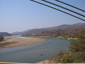
The river is 250–400 m wide in this area, and though in the dry season it may be confined to a shallow channel meandering across sandbanks, at the end of the rainy season any bridge has to be able to withstand a full-width, deep and fast-moving flood. The Great East Road runs for most of its length on watershed
Water divide
A drainage divide, water divide, divide or watershed is the line separating neighbouring drainage basins...
s at an elevation of around 1000 m, but the river is at an elevation of 390 m at the bottom of the valley. The bridge approaches have to contend with steep rugged slopes and deep ravines covered in forest or thick bush; the area is remote and about 250 km from the nearest city, Lusaka
Lusaka
Lusaka is the capital and largest city of Zambia. It is located in the southern part of the central plateau, at an elevation of about 1,300 metres . It has a population of about 1.7 million . It is a commercial centre as well as the centre of government, and the four main highways of Zambia head...
.
The First Luangwa Bridge was built in Zambia's colonial
Colonialism
Colonialism is the establishment, maintenance, acquisition and expansion of colonies in one territory by people from another territory. It is a process whereby the metropole claims sovereignty over the colony and the social structure, government, and economics of the colony are changed by...
era in 1932 as a narrow 300 m long wide steel and reinforced concrete deck on concrete piers and columns, financed, like the Chirundu Bridge
Chirundu Bridge
The Chirundu Bridge now consists of two road bridges side by side across the Zambezi River between the small town of Chirundu, Zambia and the village of Chirundu, Zimbabwe. At this location around 65 km downstream from the Kariba Dam the river is about 400 m wide...
and Beit Bridge by the Beit Trust. Its proximity to Mozambique
Mozambique
Mozambique, officially the Republic of Mozambique , is a country in southeastern Africa bordered by the Indian Ocean to the east, Tanzania to the north, Malawi and Zambia to the northwest, Zimbabwe to the west and Swaziland and South Africa to the southwest...
(about 2 km) and Rhodesia
Rhodesia
Rhodesia , officially the Republic of Rhodesia from 1970, was an unrecognised state located in southern Africa that existed between 1965 and 1979 following its Unilateral Declaration of Independence from the United Kingdom on 11 November 1965...
(60 km), as well as its status as the only access point within the country for Zambia's Eastern Province
Eastern Province, Zambia
Eastern Province is one of Zambia's nine provinces. The province lies between the Luangwa River and the border with Malawi, from Isoka in the northeast to just north of Luangwa in the south.The provincial capital is Chipata...
, makes it strategically vulnerable in any conflict. After Zambia's independence
Independence
Independence is a condition of a nation, country, or state in which its residents and population, or some portion thereof, exercise self-government, and usually sovereignty, over its territory....
in 1964, President Kenneth Kaunda's support for freedom fighters in neighbouring countries led to the bridge being destroyed in revenge.
The Second Luangwa Bridge (opened in 1968) was built quickly above the first, with aid from Britain
United Kingdom
The United Kingdom of Great Britain and Northern IrelandIn the United Kingdom and Dependencies, other languages have been officially recognised as legitimate autochthonous languages under the European Charter for Regional or Minority Languages...
which had been the colonial power in Zambia. It is a cable-stayed bridge
Cable-stayed bridge
A cable-stayed bridge is a bridge that consists of one or more columns , with cables supporting the bridge deck....
designed by Freeman Fox & Partners and built by the Cleveland Bridge Company. It has a composite steel-reinforced concrete deck 9.8 m wide, two H-shaped steel pylons 42 m tall on two reinforced concrete piers, and steel cables. The main span is 222 m with approach spans of 40 m each.
In 1979 the military of Zimbabwe-Rhodesia destroyed the bridge as well as the Chambeshi road and rail bridges in order to stop the planned invasion of their country by the Zimbabwe People's Revolutionary Army (ZIPRA).
After another two decades of use, the bridge was rehabilitated under a project of the National Road Fund Agency funded by Danish aid.

