

Mam Tor
Encyclopedia
Mam Tor is a 517 m hill near Castleton in the High Peak of Derbyshire
, England. Its name literally translates as Heights of the Mother and it is also known as the Shivering Mountain on account of the instability of its lower shale
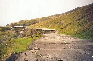
layers. Indeed, in 1979 the continual battle to maintain the A625 road
(Sheffield
to Chapel en le Frith) on the crumbling southern side of the hill was lost when the road officially closed as a through-route.
At the base of the Tor and nearby are four show caves: Blue John Cavern
, Speedwell Cavern
, Peak Cavern
and Treak Cliff Cavern
where lead
, Blue John, fluor spar and other minerals were once mined.
(a steep and narrow limestone gorge), forms the eastern end of Rushup Edge
, and dominates the western end of the "Great Ridge
", one of the most famous, beautiful, and easy-to-reach ridgewalks in the Peak District
and which separates the two arms of the Hope Valley
: the valley of the River Noe
(Edale
) to the north, and the Peakshole Water
(Castleton) to the south.
Mam Tor is made of rocks of Carboniferous
age, approximately 320 million years old. The base of Mam Tor is composed of black shale
s of the Bowland Shale Formation of Serpukhovian
age overlain by tubiditic
sandstone
of the Mam Tor Sandstone Formation of Bashkirian
age.
In perfect weather conditions, Manchester
City Centre, Stockport
, and Winter Hill
can be seen from here.
 One of the distinguishing features of Mam Tor Peak is the active debris flow
resulting from a rotational landslide
that occurred roughly 4,000 years ago. The initial failure exposed bedrock displaying a sequence of shales
and sandstones near to the summit. Evidence for the continued movement of the slide mass is demonstrated graphically by the continued severe damage to the old A625 road
that traversed this flow. The road was originally built at the beginning of the 1800s and was subsequently relaid until local authorities closed the road in 1979. Layers of tarmac and gravel are up to 2 metres thick in places, demonstrating the numerous efforts to keep the road open.
Current mean annual movement according to a study made in 2000 is:
The debris flow poses no threat to any inhabited buildings near the peak; however, small farm buildings lying in the flow's path may become inundated over the next century assuming a flow rate similar to that of the present. The 2000 study suggests that deep drainage may be the most effective means of stabilising the flow, though this may not completely stop movement.
and early Iron Age
hill fort
. Radiocarbon analysis suggests occupation from around 1200 BC. The earliest remaining features are two Bronze Age burial mounds, one just below the summit and the other on the summit itself. At a later stage over a hundred small platforms were levelled into the hill near the summit, allowing inhabited timber huts to be constructed.
Derbyshire
Derbyshire is a county in the East Midlands of England. A substantial portion of the Peak District National Park lies within Derbyshire. The northern part of Derbyshire overlaps with the Pennines, a famous chain of hills and mountains. The county contains within its boundary of approx...
, England. Its name literally translates as Heights of the Mother and it is also known as the Shivering Mountain on account of the instability of its lower shale
Shale
Shale is a fine-grained, clastic sedimentary rock composed of mud that is a mix of flakes of clay minerals and tiny fragments of other minerals, especially quartz and calcite. The ratio of clay to other minerals is variable. Shale is characterized by breaks along thin laminae or parallel layering...
layers. Indeed, in 1979 the continual battle to maintain the A625 road
A625 road
The A625 is a rural road which runs through north Derbyshire and the Peak District. First named Ecclesall Road, it begins at the Moore Street roundabout in Sheffield and runs southwesterly towards Hathersage after a change in name to Hathersage Road...
(Sheffield
Sheffield
Sheffield is a city and metropolitan borough of South Yorkshire, England. Its name derives from the River Sheaf, which runs through the city. Historically a part of the West Riding of Yorkshire, and with some of its southern suburbs annexed from Derbyshire, the city has grown from its largely...
to Chapel en le Frith) on the crumbling southern side of the hill was lost when the road officially closed as a through-route.
At the base of the Tor and nearby are four show caves: Blue John Cavern
Blue John Cavern
The Blue John Cavern is one of the four show caves in Castleton, Derbyshire, England. The cavern, which takes its name from the semi-precious mineral "Blue John" or "Derbyshire Spar", is still mined for the mineral outside of the tourist season. The small amounts taken are turned into locally-made...
, Speedwell Cavern
Speedwell Cavern
The Speedwell Cavern is one of the four show caves in Castleton, Derbyshire, England.It consists of a horizontal lead miners' adit leading to the cavern itself, a limestone cave...
, Peak Cavern
Peak Cavern
The Peak Cavern, also known as the Devil's Arse , is one of the four show caves in Castleton, Derbyshire, England...
and Treak Cliff Cavern
Treak Cliff Cavern
Treak Cliff Cavern is a show cave near Castleton in Derbyshire. It is part of the Castleton Site of Special Scientific Interest and by agreement with English Nature all the Blue John stone deposits on the visitor route are preserved. However, Blue John is regularly mined from areas not seen by...
where lead
Lead
Lead is a main-group element in the carbon group with the symbol Pb and atomic number 82. Lead is a soft, malleable poor metal. It is also counted as one of the heavy metals. Metallic lead has a bluish-white color after being freshly cut, but it soon tarnishes to a dull grayish color when exposed...
, Blue John, fluor spar and other minerals were once mined.
Geography
Mam Tor is near the top of Winnats PassWinnats Pass
Winnats Pass is in the High Peak area of the English county of Derbyshire. It lies to the west of the village of Castleton, in the National Trust's High Peak Estate. The road winds through a cleft, surrounded by towering limestone pinnacles...
(a steep and narrow limestone gorge), forms the eastern end of Rushup Edge
Rushup Edge
Rushup Edge is a ridge in the Derbyshire Peak District of England. The ridge's highest point is Lord's Seat at , while Mam Tor lies at its eastern end, beyond which the Great Ridge runs.-References:...
, and dominates the western end of the "Great Ridge
Great Ridge
The Great Ridge, is a ridge separating the vales of Edale and Castleton. It covers approximately 3 kilometres from Mam Tor at the western end of the ridge to Lose Hill at the eastern end, the lowest point being Hollins Cross, where the most often used path up to, or over the ridge, runs.A path runs...
", one of the most famous, beautiful, and easy-to-reach ridgewalks in the Peak District
Peak District
The Peak District is an upland area in central and northern England, lying mainly in northern Derbyshire, but also covering parts of Cheshire, Greater Manchester, Staffordshire, and South and West Yorkshire....
and which separates the two arms of the Hope Valley
Hope Valley, Derbyshire
The Hope Valley is a rural area centred on the village of Hope, Derbyshire in the Peak District in the northern Midlands of England.The name also applies to the Post Town which includes the surrounding villages.-The Valley:...
: the valley of the River Noe
River Noe
The River Noe is a tributary of the River Derwent in Derbyshire, England. It flows approximately 7.5 miles from its source, the confluence of two streams running off Kinder Scout in the Peak District, east through Edale and then southeast through the village of Hope.The river flows into the River...
(Edale
Edale
Edale is a small Derbyshire village and Civil parish in the Peak District, in the Midlands of England. The Parish of Edale,area ,is in the Borough of High Peak....
) to the north, and the Peakshole Water
Peakshole Water
Peakshole Water is a stream in the Peak District, Derbyshire named after its source Peak Cavern. It flows through the village of Castleton to join the River Noe in nearby Hope.-References:*...
(Castleton) to the south.
Mam Tor is made of rocks of Carboniferous
Carboniferous
The Carboniferous is a geologic period and system that extends from the end of the Devonian Period, about 359.2 ± 2.5 Mya , to the beginning of the Permian Period, about 299.0 ± 0.8 Mya . The name is derived from the Latin word for coal, carbo. Carboniferous means "coal-bearing"...
age, approximately 320 million years old. The base of Mam Tor is composed of black shale
Shale
Shale is a fine-grained, clastic sedimentary rock composed of mud that is a mix of flakes of clay minerals and tiny fragments of other minerals, especially quartz and calcite. The ratio of clay to other minerals is variable. Shale is characterized by breaks along thin laminae or parallel layering...
s of the Bowland Shale Formation of Serpukhovian
Serpukhovian
The Serpukhovian is in the ICS geologic timescale the uppermost stage or youngest age of the Mississippian, the lower subsystem of the Carboniferous. The Serpukhovian age lasted from 328.3 Ma tot 318.1 Ma...
age overlain by tubiditic
Turbidite
Turbidite geological formations have their origins in turbidity current deposits, which are deposits from a form of underwater avalanche that are responsible for distributing vast amounts of clastic sediment into the deep ocean.-The ideal turbidite sequence:...
sandstone
Sandstone
Sandstone is a sedimentary rock composed mainly of sand-sized minerals or rock grains.Most sandstone is composed of quartz and/or feldspar because these are the most common minerals in the Earth's crust. Like sand, sandstone may be any colour, but the most common colours are tan, brown, yellow,...
of the Mam Tor Sandstone Formation of Bashkirian
Bashkirian
The Bashkirian is in the ICS geologic timescale the lowest stage or oldest age of the Pennsylvanian, the youngest subsystem of the Carboniferous...
age.
In perfect weather conditions, Manchester
Manchester
Manchester is a city and metropolitan borough in Greater Manchester, England. According to the Office for National Statistics, the 2010 mid-year population estimate for Manchester was 498,800. Manchester lies within one of the UK's largest metropolitan areas, the metropolitan county of Greater...
City Centre, Stockport
Stockport
Stockport is a town in Greater Manchester, England. It lies on elevated ground southeast of Manchester city centre, at the point where the rivers Goyt and Tame join and create the River Mersey. Stockport is the largest settlement in the metropolitan borough of the same name...
, and Winter Hill
Winter Hill (Lancashire)
Winter Hill is a hill on the border of the boroughs of Chorley, Blackburn with Darwen and Bolton, in North West England. It is located on Rivington Moor, Chorley and is high...
can be seen from here.
Mam Tor landslide
Debris flow
A debris flow is a fast moving, liquefied landslide of unconsolidated, saturated debris that looks like flowing concrete. It is differentiated from a mudflow in terms of the viscosity and textural properties of the flow. Flows can carry material ranging in size from clay to boulders, and may...
resulting from a rotational landslide
Landslide
A landslide or landslip is a geological phenomenon which includes a wide range of ground movement, such as rockfalls, deep failure of slopes and shallow debris flows, which can occur in offshore, coastal and onshore environments...
that occurred roughly 4,000 years ago. The initial failure exposed bedrock displaying a sequence of shales
Shalës
Shalës is a municipality in the Elbasan District, Elbasan County, central Albania. The municipality consists of the villages Shalës, Licaj, Kurtalli, Xibrake, Xherie and Kodras....
and sandstones near to the summit. Evidence for the continued movement of the slide mass is demonstrated graphically by the continued severe damage to the old A625 road
A625 road
The A625 is a rural road which runs through north Derbyshire and the Peak District. First named Ecclesall Road, it begins at the Moore Street roundabout in Sheffield and runs southwesterly towards Hathersage after a change in name to Hathersage Road...
that traversed this flow. The road was originally built at the beginning of the 1800s and was subsequently relaid until local authorities closed the road in 1979. Layers of tarmac and gravel are up to 2 metres thick in places, demonstrating the numerous efforts to keep the road open.
Current mean annual movement according to a study made in 2000 is:
up to 0.25 m; this increases greatly when winter rainfalls exceed thresholds of both 210 mm/month and 750 mm in the preceding six months
The debris flow poses no threat to any inhabited buildings near the peak; however, small farm buildings lying in the flow's path may become inundated over the next century assuming a flow rate similar to that of the present. The 2000 study suggests that deep drainage may be the most effective means of stabilising the flow, though this may not completely stop movement.
Prehistory
The summit of Mam Tor is encircled by a late Bronze AgeBronze Age
The Bronze Age is a period characterized by the use of copper and its alloy bronze as the chief hard materials in the manufacture of some implements and weapons. Chronologically, it stands between the Stone Age and Iron Age...
and early Iron Age
Iron Age
The Iron Age is the archaeological period generally occurring after the Bronze Age, marked by the prevalent use of iron. The early period of the age is characterized by the widespread use of iron or steel. The adoption of such material coincided with other changes in society, including differing...
hill fort
Hill fort
A hill fort is a type of earthworks used as a fortified refuge or defended settlement, located to exploit a rise in elevation for defensive advantage. They are typically European and of the Bronze and Iron Ages. Some were used in the post-Roman period...
. Radiocarbon analysis suggests occupation from around 1200 BC. The earliest remaining features are two Bronze Age burial mounds, one just below the summit and the other on the summit itself. At a later stage over a hundred small platforms were levelled into the hill near the summit, allowing inhabited timber huts to be constructed.
See also
- Breast shaped hillBreast shaped hillA breast-shaped hill is a mountain in the shape of a human breast. Such anthropomorphic geographic features are to be found in different places of the world and in some cultures they were revered as the attributes of the Mother Goddess, like the Paps of Anu, named after Anu, an important goddess of...
- EdaleEdaleEdale is a small Derbyshire village and Civil parish in the Peak District, in the Midlands of England. The Parish of Edale,area ,is in the Borough of High Peak....
- List of hill forts in England
- Pennine WayPennine WayThe Pennine Way is a National Trail in England. The trail runs from Edale, in the northern Derbyshire Peak District, north through the Yorkshire Dales and the Northumberland National Park and ends at Kirk Yetholm, just inside the Scottish border. The path runs along the Pennine hills, sometimes...
External links
- Mam Tor Landslide British Geological Survey