Mount Baker Wilderness
Encyclopedia

contains 117528 acres (475.6 km²). Its eastern border is shared with the boundary of the North Cascades National Park
North Cascades National Park
North Cascades National Park is a U.S. National Park located in the state of Washington. The park is the largest of the three National Park Service units that comprise the North Cascades National Park Service Complex. Several national wilderness areas and British Columbia parkland adjoin the...
for a distance of 40 miles (65 kilometers). The Wilderness extends from State Route 20
State Route 20 (Washington)
State Route 20, also known alternately as the North-Cross Highway, SR 20 or the North Cascades Highway, is a State Highway in the State of Washington. It travels from an intersection with U.S. Route 101 at Discovery Bay near Port Townsend to Newport at a junction with U.S. Route 2 about 400 feet ...
north to the Canadian
Canada
Canada is a North American country consisting of ten provinces and three territories. Located in the northern part of the continent, it extends from the Atlantic Ocean in the east to the Pacific Ocean in the west, and northward into the Arctic Ocean...
border. On the west, it is bounded by the foothills of the Puget Sound
Puget Sound
Puget Sound is a sound in the U.S. state of Washington. It is a complex estuarine system of interconnected marine waterways and basins, with one major and one minor connection to the Strait of Juan de Fuca and the Pacific Ocean — Admiralty Inlet being the major connection and...
lowlands.

Whatcom County, Washington
Whatcom County is a county located in the U.S. state of Washington. Its name ultimately derives from the Lummi word Xwotʼqom, meaning "noisy water." As of 2010, the population was 201,140. The county seat is at Bellingham, which is also the county's largest city...
, the wilderness lies on the western slopes of the Cascade Mountains. The three forks of the Nooksack River
Nooksack River
The Nooksack River is a river in the northwest part of the U.S. state of Washington. It drains an area of the Cascade Range around Mount Baker, near the Canadian border. The lower river flows through a fertile agricultural area before emptying into Bellingham Bay and, via the Strait of Juan de Fuca...
and the Baker River
Baker River (Washington)
The Baker River is an approximately , southward-flowing tributary of the Skagit River in northwestern Washington in the United States. It drains an area of the high North Cascades in the watershed of Puget Sound north of Seattle, and east of Mount Baker...
are the major drainages of the wilderness.
Vegetative cover is typical of the west slopes of the Cascades including Western Redcedar
Thuja plicata
Thuja plicata, commonly called Western or pacific red cedar, giant or western arborvitae, giant cedar, or shinglewood, is a species of Thuja, an evergreen coniferous tree in the cypress family Cupressaceae native to western North America...
, Coast Douglas-fir
Coast Douglas-fir
Pseudotsuga menziesii, known as Douglas-fir, Oregon Pine, or Douglas spruce, is an evergreen conifer species native to western North America. Its variety Pseudotsuga menziesii var. menziesii, also known as coast Douglas-fir grows in the coastal regions, from west-central British Columbia, Canada...
, Noble Fir
Noble Fir
Abies procera, the Noble Fir, is a western North American fir, native to the Cascade Range and Coast Range mountains of extreme northwest California and western Oregon and Washington in the United States...
, Pacific Silver Fir
Pacific Silver Fir
Abies amabilis, commonly known as the Pacific silver fir, is a fir native to the Pacific Northwest of North America, occurring in the Pacific Coast Ranges and the Cascade Range from the extreme southeast of Alaska, through western British Columbia, Washington and Oregon, to the extreme northwest of...
, Subalpine Fir
Subalpine Fir
The Subalpine Fir or Rocky Mountain Fir is a western North American fir, native to the mountains of Yukon, British Columbia and western Alberta in Canada; southeastern Alaska, Washington, Oregon, Idaho, western Montana, Wyoming, Utah, Colorado, New Mexico, Arizona, northeastern Nevada, and the...
, Western Hemlock
Western Hemlock
Tsuga heterophylla. the Western Hemlock, is a species of hemlock native to the west coast of North America, with its northwestern limit on the Kenai Peninsula, Alaska, and its southeastern limit in northern Sonoma County, California.-Habitat:...
and Mountain Hemlock
Mountain Hemlock
Tsuga mertensiana, known as Mountain Hemlock, is a species of hemlock native to the west coast of North America, with its northwestern limit on the Kenai Peninsula, Alaska, and its southeastern limit in northern Tulare County, California....
, and at higher elevations, alpine meadow
Alpine tundra
Alpine tundra is a natural region that does not contain trees because it is at high altitude. Alpine tundra is distinguished from arctic tundra, because alpine soils are generally better drained than arctic soils...
s. Animals include Mountain Goat
Mountain goat
The Mountain Goat , also known as the Rocky Mountain Goat, is a large-hoofed mammal found only in North America. Despite its vernacular name, it is not a member of Capra, the genus of true goats...
s and Hoary Marmot
Hoary Marmot
The hoary marmot is a species of marmot that inhabits the mountains of northwest North America. Hoary marmots live near the tree line on slopes with grasses and forbs to eat and rocky areas for cover....
s. On mountains and higher ridges, considerable areas of rock and permanent glaciers (over 10,000 acres (40 km2)) occur.
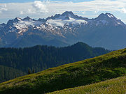
The terrain is rugged, with steep slopes and numerous ridges dissected by small intermittent or permanent drainages. Mount Baker
Mount Baker
Mount Baker , also known as Koma Kulshan or simply Kulshan, is an active glaciated andesitic stratovolcano in the Cascade Volcanic Arc and the North Cascades of Washington State in the United States. It is the second-most active volcano in the range after Mount Saint Helens...
, an active volcano, is one of the area's most distinctive features. The mountain periodically exhibits thermal activity. The most northern of Washington's volcanoes it stands at 10778 feet (3,285.1 m). Other major mountains include:
- Twin Sisters MountainTwin Sisters MountainTwin Sisters Mountain, commonly called the Twin Sisters, is a mountain in the U.S. state of Washington. Part of the Cascade Range, it lies just southwest of Mount Baker. Of its two main peaks, South Twin is higher, at...
, North Twin — 6570 feet (2,002.5 m) - Twin Sisters Mountain, South Twin — 6932 feet (2,112.9 m)
- Tomyhoi Peak — 7451 feet (2,271.1 m)
- American Border PeakAmerican Border PeakAmerican Border Peak is a mountain just south of the US-Canada border, in the North Cascades of Washington state, with a corresponding sister peak, Canadian Border Peak, just north along a col connecting to it across the border. It is located within the Mount Baker Wilderness, part of the Mount...
— 8026 feet (2,446.3 m) - Mount Larrabee (formerly Red Mountain) — 7868 feet (2,398.2 m)
- Goat Mountain — 6820 feet (2,078.7 m)
- Mount Sefrit — 7191 feet (2,191.8 m)
- Ruth Mountain — 7115 feet (2,168.7 m)
- Hadley Peak — 7515 feet (2,290.6 m)
The Wilderness is wholly contained within Mount Baker-Snoqualmie National Forest
Mount Baker-Snoqualmie National Forest
The Mount Baker-Snoqualmie National Forest in Washington extends more than along the western slopes of the Cascade Range from the Canadian border to the northern boundary of Mount Rainier National Park. Forest headquarters are located in the city of Everett....
and is adjacent to the Mount Baker National Recreation Area
Mount Baker National Recreation Area
Mount Baker National Recreation Area is a United States National Recreation Area located in northern Washington about 15 miles south of the Canadian border within the Mount Baker-Snoqualmie National Forest....
.
See also
- Mount Baker-Snoqualmie National ForestMount Baker-Snoqualmie National ForestThe Mount Baker-Snoqualmie National Forest in Washington extends more than along the western slopes of the Cascade Range from the Canadian border to the northern boundary of Mount Rainier National Park. Forest headquarters are located in the city of Everett....
- Ecology of the North CascadesEcology of the North CascadesThe Ecology of the North Cascades is heavily influenced by the high elevation and rain shadow effects of the mountain range. The North Cascades is a section of the Cascade Range from the South Fork of the Snoqualmie River in Washington, United States, to the confluence of the Thompson and Fraser...
External links
- USFS Mount Baker Wilderness page (adapted PD source)

