
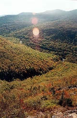
Mount Redington
Encyclopedia
Mount Redington is a mountain
located in Franklin County
, Maine
.
Redington is flanked to the northeast by South Crocker Mountain
and to the west by Black Nubble
.
Redington stands just northeast of the U.S. Navy Survival Escape and Evasion Training Facility (USSEAETF).
The southeast side of Redington drains into the South Branch of the Carrabassett River
, thence into the Kennebec River
, and into the Gulf of Maine
.
The northwest side of Redington drains into Nash Stream, thence into the South Branch of the Dead River
, Flagstaff Lake
, the Dead River and the Kennebec.
The Appalachian Trail
(AT), a 2,170-mile (3,500-km) National Scenic Trail
from Georgia
to Maine
, is routed around Mt. Redington, to instead pass over the summit of Sugarloaf Mountain
(4250 feet (1,295.4 m)) — the second highest peak in the state of Maine.
The AT runs from Saddleback Junior
to the southwest, over Spaulding Mountain
and Sugarloaf to the east, and passes about a mile northeast of Redington, at the summit of South Crocker
.
Mount Redington and Owl's Head
in New Hampshire are the only New England four-thousand footers
without a maintained trail to the summit.
 In 2005, Maine Mountain Power filed an application with the Maine Land Use Regulation Committee (LURC) for a permit to develop a 30-turbine
wind farm
on Redington and neighboring Black Nubble
.
After years of contentious debate, the proposal was voted down by the LURC in 2007. The summit of Redington was seen as too ecologically sensitive — a sub-alpine fir habitat providing a home for two rare species, the bog lemming
and Bicknell's thrush
. Also, the development would have been visible for miles along the AT.
A revised proposal, which would have developed wind power only on Black Nubble, was rejected by the LURC in 2008.
As of early 2009, the wind farm project was being planned as the Sugarloaf Community Wind Farm
.
Mountain
Image:Himalaya_annotated.jpg|thumb|right|The Himalayan mountain range with Mount Everestrect 58 14 160 49 Chomo Lonzorect 200 28 335 52 Makalurect 378 24 566 45 Mount Everestrect 188 581 920 656 Tibetan Plateaurect 250 406 340 427 Rong River...
located in Franklin County
Franklin County, Maine
Franklin County is a county located in the U.S. state of Maine. As of 2010, the population was 30,768. Its county seat is Farmington.Franklin County was established on 9 May 1838.-Geography:...
, Maine
Maine
Maine is a state in the New England region of the northeastern United States, bordered by the Atlantic Ocean to the east and south, New Hampshire to the west, and the Canadian provinces of Quebec to the northwest and New Brunswick to the northeast. Maine is both the northernmost and easternmost...
.
Redington is flanked to the northeast by South Crocker Mountain
South Crocker Mountain
South Crocker Mountain is a mountain located in Franklin County, Maine.South Crocker Mtn. is flanked to the north by Crocker Mountain, and to the southwest by Mount Redington....
and to the west by Black Nubble
Black Nubble (Redington Township, Maine)
Black Nubble is a mountain located in Franklin County, Maine.Black Nubble is flanked to the southeast by Mount Redington. Redington stands just north of the U.S. Navy Survival Escape and Evasion Training Facility ....
.
Redington stands just northeast of the U.S. Navy Survival Escape and Evasion Training Facility (USSEAETF).
The southeast side of Redington drains into the South Branch of the Carrabassett River
Carrabassett River
The Carrabassett River, a tributary of the Kennebec River, is located in Franklin County and Somerset County, Maine, in the United States. It rises near Sugarloaf Mountain, east of Rangeley Lake, and runs for , flowing southeast past Kingfield and joining the Kennebec River in the town of...
, thence into the Kennebec River
Kennebec River
The Kennebec River is a river that is entirely within the U.S. state of Maine. It rises in Moosehead Lake in west-central Maine. The East and West Outlets join at Indian Pond and the river then flows southward...
, and into the Gulf of Maine
Gulf of Maine
The Gulf of Maine is a large gulf of the Atlantic Ocean on the east coast of North America.It is delineated by Cape Cod at the eastern tip of Massachusetts in the southwest and Cape Sable at the southern tip of Nova Scotia in the northeast. It includes the entire coastlines of the U.S...
.
The northwest side of Redington drains into Nash Stream, thence into the South Branch of the Dead River
South Branch Dead River
The South Branch Dead River is a tributary of the Dead River in Franklin County, Maine.From the outflow of Saddleback Lake below Saddleback Mountain, the river runs northeast to Eustis, where its confluence with the North Branch of the Dead River was drowned by the impoundment of Flagstaff Lake...
, Flagstaff Lake
Flagstaff Lake (Maine)
Flagstaff Lake is located in Somerset County and Franklin County, Maine in the United States. The North Branch Dead River and South Branch Dead River join in the lake, forming the Dead River....
, the Dead River and the Kennebec.
The Appalachian Trail
Appalachian Trail
The Appalachian National Scenic Trail, generally known as the Appalachian Trail or simply the AT, is a marked hiking trail in the eastern United States extending between Springer Mountain in Georgia and Mount Katahdin in Maine. It is approximately long...
(AT), a 2,170-mile (3,500-km) National Scenic Trail
National Scenic Trail
National Scenic Trail is a designation for protected areas in the United States that consist of trails of particular natural beauty.National Scenic Trails were authorized under the National Trails System Act of 1968 along with National Historic Trails and National Recreation Trails...
from Georgia
Georgia (U.S. state)
Georgia is a state located in the southeastern United States. It was established in 1732, the last of the original Thirteen Colonies. The state is named after King George II of Great Britain. Georgia was the fourth state to ratify the United States Constitution, on January 2, 1788...
to Maine
Maine
Maine is a state in the New England region of the northeastern United States, bordered by the Atlantic Ocean to the east and south, New Hampshire to the west, and the Canadian provinces of Quebec to the northwest and New Brunswick to the northeast. Maine is both the northernmost and easternmost...
, is routed around Mt. Redington, to instead pass over the summit of Sugarloaf Mountain
Sugarloaf Mountain (Franklin County, Maine)
Sugarloaf Mountain is a mountain located in Franklin County, Maine. It is the second highest mountain in the state, after Mount Katahdin. Sugarloaf is flanked to the south by Spaulding Mountain....
(4250 feet (1,295.4 m)) — the second highest peak in the state of Maine.
The AT runs from Saddleback Junior
Saddleback Junior
Saddleback Junior is a mountain located in Franklin County, Maine.Saddleback Junior is flanked to the southwest by Saddleback Horn, and to the northeast by Poplar Ridge.The mountain is on the south border of the U.S...
to the southwest, over Spaulding Mountain
Spaulding Mountain
Spaulding Mountain is a mountain located in Franklin County, Maine.Spaulding Mtn. is flanked to the northeast by Sugarloaf Mountain, and to the southeast by Mount Abraham.The northeast and south sides of Spaulding Mtn...
and Sugarloaf to the east, and passes about a mile northeast of Redington, at the summit of South Crocker
South Crocker Mountain
South Crocker Mountain is a mountain located in Franklin County, Maine.South Crocker Mtn. is flanked to the north by Crocker Mountain, and to the southwest by Mount Redington....
.
Mount Redington and Owl's Head
Owl's Head (Franconia)
Owl's Head is a mountain in Franconia, New Hampshire. It lies between the Franconia Branch of the Pemigewasset River and Lincoln Brook , in the Pemigewasset Wilderness of the White Mountain National Forest....
in New Hampshire are the only New England four-thousand footers
Four-thousand footers
The term Four-Thousand Footers refers to a group of forty-eight mountains in New Hampshire at least 4,000 feet above sea level...
without a maintained trail to the summit.
Wind farm proposal
Wind turbine
A wind turbine is a device that converts kinetic energy from the wind into mechanical energy. If the mechanical energy is used to produce electricity, the device may be called a wind generator or wind charger. If the mechanical energy is used to drive machinery, such as for grinding grain or...
wind farm
Wind farm
A wind farm is a group of wind turbines in the same location used to produce electric power. A large wind farm may consist of several hundred individual wind turbines, and cover an extended area of hundreds of square miles, but the land between the turbines may be used for agricultural or other...
on Redington and neighboring Black Nubble
Black Nubble (Redington Township, Maine)
Black Nubble is a mountain located in Franklin County, Maine.Black Nubble is flanked to the southeast by Mount Redington. Redington stands just north of the U.S. Navy Survival Escape and Evasion Training Facility ....
.
After years of contentious debate, the proposal was voted down by the LURC in 2007. The summit of Redington was seen as too ecologically sensitive — a sub-alpine fir habitat providing a home for two rare species, the bog lemming
Bog lemming
The genus Synaptomys is a group of North American lemmings.These animals live in wet forested and open areas. They are small round rodents with large heads, short ears, legs and tails. They eat green vegetation such as grasses and sedges...
and Bicknell's thrush
Bicknell's Thrush
The Bicknell's Thrush, Catharus bicknelli, is a medium-sized thrush, at 17.5 cm and 28 g . It was named after Eugene Bicknell, an American amateur ornithologist, who discovered the species on Slide Mountain in the Catskills in the late 19th century.Adults are olive-brown on the upperparts,...
. Also, the development would have been visible for miles along the AT.
A revised proposal, which would have developed wind power only on Black Nubble, was rejected by the LURC in 2008.
As of early 2009, the wind farm project was being planned as the Sugarloaf Community Wind Farm
Sugarloaf Community Wind Farm
The Sugarloaf Community Wind Farm is a wind power project in western Maine under development by Endless Energy Corporation. The wind farm is planned to be situated between the Sugarloaf and the Saddleback Maine ski resorts on Redington Pond Range and Black Nubble Mountains.The 30 wind turbine...
.