Mountains of Kong
Encyclopedia

England
England is a country that is part of the United Kingdom. It shares land borders with Scotland to the north and Wales to the west; the Irish Sea is to the north west, the Celtic Sea to the south west, with the North Sea to the east and the English Channel to the south separating it from continental...
map
Map
A map is a visual representation of an area—a symbolic depiction highlighting relationships between elements of that space such as objects, regions, and themes....
s of Africa
Africa
Africa is the world's second largest and second most populous continent, after Asia. At about 30.2 million km² including adjacent islands, it covers 6% of the Earth's total surface area and 20.4% of the total land area...
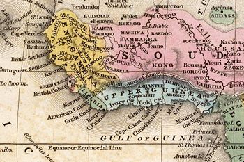
from 1798 through the late 1880s. An early map resulting from exploration of the area and showing this west to east mountain range in 1798 was produced by English cartographer
Cartography
Cartography is the study and practice of making maps. Combining science, aesthetics, and technique, cartography builds on the premise that reality can be modeled in ways that communicate spatial information effectively.The fundamental problems of traditional cartography are to:*Set the map's...
James Rennell
James Rennell
Major James Rennell, FRS was an English geographer, historian and a pioneer of oceanography.-Early life:Rennell was born near Chudleigh in Devon...
. The mountains were thought to begin in West Africa
West Africa
West Africa or Western Africa is the westernmost region of the African continent. Geopolitically, the UN definition of Western Africa includes the following 16 countries and an area of approximately 5 million square km:-Flags of West Africa:...
near the highland
Highland (geography)
The term highland or upland is used to denote any mountainous region or elevated mountainous plateau. Generally speaking, the term upland tends to be used for ranges of hills, typically up to 500-600m, and highland for ranges of low mountains.The Scottish Highlands refers to the mountainous...
source of the Niger River
Niger River
The Niger River is the principal river of western Africa, extending about . Its drainage basin is in area. Its source is in the Guinea Highlands in southeastern Guinea...
near Tembakounda in Guinea
Guinea
Guinea , officially the Republic of Guinea , is a country in West Africa. Formerly known as French Guinea , it is today sometimes called Guinea-Conakry to distinguish it from its neighbour Guinea-Bissau. Guinea is divided into eight administrative regions and subdivided into thirty-three prefectures...
, then continue east to the also fictitious Central Africa
Central Africa
Central Africa is a core region of the African continent which includes Burundi, the Central African Republic, Chad, the Democratic Republic of the Congo, and Rwanda....
n Mountains of the Moon
Mountains of the Moon (Africa)
The term Mountains of the Moon or Montes Lunae referred to a mountain range in central Africa that is the source of the White Nile.- Ancient testimony :...
, thought to be where the White Nile
White Nile
The White Nile is a river of Africa, one of the two main tributaries of the Nile from Egypt, the other being the Blue Nile. In the strict meaning, "White Nile" refers to the river formed at Lake No at the confluence of the Bahr al Jabal and Bahr el Ghazal rivers...
rose. Cartographers stopped including the mountains on maps after French
France
The French Republic , The French Republic , The French Republic , (commonly known as France , is a unitary semi-presidential republic in Western Europe with several overseas territories and islands located on other continents and in the Indian, Pacific, and Atlantic oceans. Metropolitan France...
explorer Louis Gustave Binger
Louis Gustave Binger
Louis Gustave Binger was a French officer and explorer who claimed the Côte d'Ivoire for France.Binger was born at Strasbourg in the Bas-Rhin . In 1887 he travelled from Senegal up to the Niger River, arriving at Grand Bassam in 1889. During this expedition he discovered that the Mountains of Kong...
established that the mountains were fictitious in his 1887-1889 expedition to chart the Niger River from its mouth in the Gulf of Guinea
Gulf of Guinea
The Gulf of Guinea is the northeasternmost part of the tropical Atlantic Ocean between Cape Lopez in Gabon, north and west to Cape Palmas in Liberia. The intersection of the Equator and Prime Meridian is in the gulf....
and through Côte d'Ivoire
Côte d'Ivoire
The Republic of Côte d'Ivoire or Ivory Coast is a country in West Africa. It has an area of , and borders the countries Liberia, Guinea, Mali, Burkina Faso and Ghana; its southern boundary is along the Gulf of Guinea. The country's population was 15,366,672 in 1998 and was estimated to be...
. However, earlier explorers for some time in the nineteenth century had failed to locate this mountain range, but it continued to appear on maps until late in that century.
Various other nineteenth century explorers of West Africa included the range on maps they produced or directed the production of after exploring the area including French explorer René Caillié, who explored the highlands of Guinea, Fouta Djallon
Fouta Djallon
Fouta Djallon is a highland region in the centre of Guinea, West Africa. The indigenous name is Fuuta-Jaloo...
, near the source of the Niger, the Cornish
Cornish people
The Cornish are a people associated with Cornwall, a county and Duchy in the south-west of the United Kingdom that is seen in some respects as distinct from England, having more in common with the other Celtic parts of the United Kingdom such as Wales, as well as with other Celtic nations in Europe...
explorer Richard Lemon Lander
Richard Lemon Lander
Richard Lemon Lander was a Cornish explorer of western Africa.-Biography:Lander was the son of a Truro innkeeper, born in the Daniell Arms. Lander's explorations began as an assistant to the Scottish explorer Hugh Clapperton on an expedition to Western Africa in 1825...
and his younger brother John, and Scottish
Scotland
Scotland is a country that is part of the United Kingdom. Occupying the northern third of the island of Great Britain, it shares a border with England to the south and is bounded by the North Sea to the east, the Atlantic Ocean to the north and west, and the North Channel and Irish Sea to the...
explorer Hugh Clapperton
Hugh Clapperton
Hugh Clapperton was a Scottish traveller and explorer of West and Central Africa.He was born in Annan, Dumfriesshire, where his father was a surgeon. He gained some knowledge of practical mathematics and navigation, and at thirteen was apprenticed on board a vessel which traded between Liverpool...
who also sought the course of the Niger River in its upper reaches.

