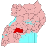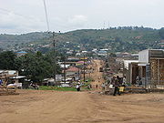
Mubende District
Encyclopedia

Districts of Uganda
Uganda is divided into 111 districts and one city across four administrative regions. Most districts are named after their main commercial and administrative towns....
in Central Uganda
Central Region, Uganda
Central Region is a region of Uganda. It is coterminous with the Kingdom of Buganda, one of the ancient African monarchies that are constitutionally recognised in Uganda. It is divided into the following districts:...
. Like most other Uganda
Uganda
Uganda , officially the Republic of Uganda, is a landlocked country in East Africa. Uganda is also known as the "Pearl of Africa". It is bordered on the east by Kenya, on the north by South Sudan, on the west by the Democratic Republic of the Congo, on the southwest by Rwanda, and on the south by...
n districts, it is named after its 'chief town', Mubende
Mubende
Mubende is a town in Central Uganda. It is the main municipal, administrative and commercial center of Mubende District and is the location of the district headquarters. Mubende is the sister city of Tumwater, Washington, USA.-Location:...
. Mubende District was reduced in size in July 2005 with the creation of Mityana District
Mityana District
Mityana District is a district in Central Uganda. The district was created in 2005, by taking the Mityana and Busujju counties from Mubende District...
.
Location
Mubende District is bordered by Kyankwanzi DistrictKyankwanzi District
Kyankwanzi District is a district in Central Uganda. The district is named after its 'chief town' of Kyankwanzi.-Location:Kyankwanzi District is bordered by Masindi District to the north, Nakaseke District to the east, Kiboga District to the southeast, Mubende District to the south, Kibaale...
to the north, Kiboga District
Kiboga District
Kiboga District is a district in Central Uganda. Like many other Ugandan districts, the district is named after its 'chief town', Kiboga, the location of the district headquarters.-Location:...
to the northeast and Mityana District
Mityana District
Mityana District is a district in Central Uganda. The district was created in 2005, by taking the Mityana and Busujju counties from Mubende District...
to the east. Gomba District
Gomba District
Gomba District is a district in Central Uganda.-Location:Gomba District is bordered by Mubende District to the north, Mityana District to the northeast and Butambala District to the east. Kalungu District, Bukomansimbi District and Sembabule District lie to the south of Gomba District...
and Sembabule District
Sembabule District
Sembambule District is a district in Central Uganda. Like most other Ugandan districts, it is named after its 'chief town', Sembabule, where the district headquarters are located.-Location:...
lie to the south, Kyegegwa District
Kyegegwa District
Kyegegwa District is a district in Western Uganda. It is named after its 'chief town', Kyegegwa, where the district headquarters are located.-Location:...
to the southwest and Kibaale District
Kibaale District
Kibaale District, sometimes spelled as Kibale District, is a district in Western Uganda. Like most other Ugandan districts, it is named after its 'chief town', Kibaale, where the district headquarters are located.-Location:...
to the northwest of Mubende District. Mubende
Mubende
Mubende is a town in Central Uganda. It is the main municipal, administrative and commercial center of Mubende District and is the location of the district headquarters. Mubende is the sister city of Tumwater, Washington, USA.-Location:...
, the district headquarters, is located approximately 172 kilometres (106.9 mi), by road, west of Kampala
Kampala
Kampala is the largest city and capital of Uganda. The city is divided into five boroughs that oversee local planning: Kampala Central Division, Kawempe Division, Makindye Division, Nakawa Division and Lubaga Division. The city is coterminous with Kampala District.-History: of Buganda, had chosen...
, the capital of Uganda
Uganda
Uganda , officially the Republic of Uganda, is a landlocked country in East Africa. Uganda is also known as the "Pearl of Africa". It is bordered on the east by Kenya, on the north by South Sudan, on the west by the Democratic Republic of the Congo, on the southwest by Rwanda, and on the south by...
, and the largest city in that country. The coordinates of Mubende District are:00 36N, 31 24E.
Overview
The district covers an area of approximately 4645 square kilometre. It has fifteen (15) lower Local Governments which include:- Bagezza Local Council
- Bukuya Local Council
- Butoloogo Local Council
- Kalwaana Local Council
- Kasambya Local Council
- Kassanda Local Council
- Kiganda Local Council
- Kigando Local Council
- Kitenga Local Council
- Kitumbi Local Council
- Kiyuuni Local Council
- Maduudu Local Council
- Mubende Town CouncilMubendeMubende is a town in Central Uganda. It is the main municipal, administrative and commercial center of Mubende District and is the location of the district headquarters. Mubende is the sister city of Tumwater, Washington, USA.-Location:...
- Mwezi Local Council
- Nabingoola Local Council
Population
In 2002 the national census estimated the population of the district to be about 436,500 people of whom 219,460 (50.3%) were males and 217,033 (59.7%) were female, with an annual population growth rate of 3.6%. It is estimated that in 2010, the population of the district was about 579,200. See table below:{| style="font-size:100%;"
|-
| width="100%" align="center" | Mubende District Population Trends
|- valign="top"
|
{| class="wikitable sortable" style="margin-left:auto;margin-right:auto"
! style="width:2em;" |Year!! Estimated Population
|-
|2002||436,500
|-
|2003||452,200
|-
|2004||468,500
|-
|2005||485,400
|-
|2006||502,800
|-
|2007||520,900
|-
|2008||539,700
|-
|2009||559,100
|-
|2010||579,200
|-
|}
Economic activity
The major economic activity in Mubende District is agriculture with emphasis on food crops like:- Sweet potatoSweet potatoThe sweet potato is a dicotyledonous plant that belongs to the family Convolvulaceae. Its large, starchy, sweet-tasting, tuberous roots are an important root vegetable. The young leaves and shoots are sometimes eaten as greens. Of the approximately 50 genera and more than 1,000 species of...
es - Beans
- CassavaCassavaCassava , also called yuca or manioc, a woody shrub of the Euphorbiaceae native to South America, is extensively cultivated as an annual crop in tropical and subtropical regions for its edible starchy tuberous root, a major source of carbohydrates...
- MaizeMaizeMaize known in many English-speaking countries as corn or mielie/mealie, is a grain domesticated by indigenous peoples in Mesoamerica in prehistoric times. The leafy stalk produces ears which contain seeds called kernels. Though technically a grain, maize kernels are used in cooking as a vegetable...
- Bananas
- Groundnuts
- Onions
- CabbageCabbageCabbage is a popular cultivar of the species Brassica oleracea Linne of the Family Brassicaceae and is a leafy green vegetable...
- TomatoTomatoThe word "tomato" may refer to the plant or the edible, typically red, fruit which it bears. Originating in South America, the tomato was spread around the world following the Spanish colonization of the Americas, and its many varieties are now widely grown, often in greenhouses in cooler...
es
Cash crops grown in the district include:
- CoffeeCoffeeCoffee is a brewed beverage with a dark,init brooo acidic flavor prepared from the roasted seeds of the coffee plant, colloquially called coffee beans. The beans are found in coffee cherries, which grow on trees cultivated in over 70 countries, primarily in equatorial Latin America, Southeast Asia,...
- TeaTeaTea is an aromatic beverage prepared by adding cured leaves of the Camellia sinensis plant to hot water. The term also refers to the plant itself. After water, tea is the most widely consumed beverage in the world...

