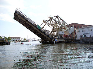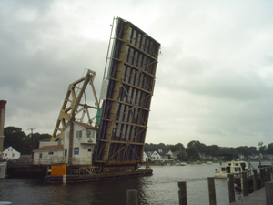
Mystic River Bascule Bridge
Encyclopedia


Bascule bridge
A bascule bridge is a moveable bridge with a counterweight that continuously balances the span, or "leaf," throughout the entire upward swing in providing clearance for boat traffic....
, a type of drawbridge
Drawbridge
A drawbridge is a type of movable bridge typically associated with the entrance of a castle surrounded by a moat. The term is often used to describe all different types of movable bridges, like bascule bridges and lift bridges.-Castle drawbridges:...
with counterweights, that spans the Mystic River
Mystic River (Connecticut)
The Mystic River is a estuary in the southeast corner of the U. S. state of Connecticut. Its main tributary is Whitford Brook. It empties into Fishers Island Sound, dividing the village of Mystic between the towns of Groton and Stonington. Much of the river is tidal...
in Mystic
Mystic, Connecticut
Mystic is a village and census-designated place in New London County, Connecticut, in the United States. The population was 4,001 at the 2000 census. A historic locality, Mystic has no independent government because it is not a legally recognized municipality in the state of Connecticut...
, Connecticut
Connecticut
Connecticut is a state in the New England region of the northeastern United States. It is bordered by Rhode Island to the east, Massachusetts to the north, and the state of New York to the west and the south .Connecticut is named for the Connecticut River, the major U.S. river that approximately...
in the United States
United States
The United States of America is a federal constitutional republic comprising fifty states and a federal district...
.
The bridge was designed by Thomas Ellis Brown of New York (formerly Chief Engineer of Otis Elevator Company
Otis Elevator Company
The Otis Elevator Company is the world's largest manufacturer of vertical transportation systems today, principally focusing on elevators and escalators...
) built in 1920 (see historical marker on site) by the J.E. FitzGerald Construction Company of New London, Connecticut
New London, Connecticut
New London is a seaport city and a port of entry on the northeast coast of the United States.It is located at the mouth of the Thames River in New London County, southeastern Connecticut....
and is of the Strauss Heel-trunnion type. It has a movable span width of 85 ft (25.9 m) and a total length of 218 ft (66.4 m). It has a movable span weight of 660 ST (589 LT; 599 t), with two concrete-filled counterweights, each of 230 ST (205 LT; 209 t). It is operated by the Connecticut Department of Transportation and connects the two halves of Mystic, allowing vehicle and foot traffic on Main Street (33 ft or 10.1 m wide) in the center of the tourist district of town. The bridge carries U.S. Route 1
U.S. Route 1
U.S. Route 1 is a major north–south U.S. Highway that serves the East Coast of the United States. It runs 2,377 miles from Fort Kent, Maine at the Canadian border south to Key West, Florida. U.S. 1 generally parallels Interstate 95, though it is significantly farther west between...
with an average daily traffic of 11,800.
It opens approximately 2,200 times per year, with each opening lasting approximately 5 minutes. The opening of the bridge is driven by two 40 hp direct current
Direct current
Direct current is the unidirectional flow of electric charge. Direct current is produced by such sources as batteries, thermocouples, solar cells, and commutator-type electric machines of the dynamo type. Direct current may flow in a conductor such as a wire, but can also flow through...
motors, each weighing 1400 pounds (635 kg). The bridge is greased and inspected every 100 openings or every two weeks during the winter. From May 1 to October 31 the bridge opens at hourly intervals, 40 minutes past the hour, during daylight hours. Outside of this time it opens on demand.

