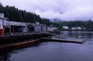
Namu, British Columbia
Encyclopedia

Canning
Canning is a method of preserving food in which the food contents are processed and sealed in an airtight container. Canning provides a typical shelf life ranging from one to five years, although under specific circumstances a freeze-dried canned product, such as canned, dried lentils, can last as...
town and First Nations
First Nations
First Nations is a term that collectively refers to various Aboriginal peoples in Canada who are neither Inuit nor Métis. There are currently over 630 recognised First Nations governments or bands spread across Canada, roughly half of which are in the provinces of Ontario and British Columbia. The...
community on the coast of British Columbia
British Columbia
British Columbia is the westernmost of Canada's provinces and is known for its natural beauty, as reflected in its Latin motto, Splendor sine occasu . Its name was chosen by Queen Victoria in 1858...
, Canada
Canada
Canada is a North American country consisting of ten provinces and three territories. Located in the northern part of the continent, it extends from the Atlantic Ocean in the east to the Pacific Ocean in the west, and northward into the Arctic Ocean...
. It is located about 95 km (59 mi) southwest of Bella Coola
Bella Coola, British Columbia
Bella Coola is a community of approximately 600 at the western extremity of the Bella Coola Valley. Bella Coola usually refers to the entire valley, encompassing the settlements of Bella Coola proper , Lower Bella Coola, Hagensborg, Saloompt, Nusatsum, Firvale and Stuie...
or 35 km (21.7 mi) SSE of Bella Bella
Bella Bella, British Columbia
Bella Bella, also known as Waglisla, is an unincorporated community and Indian Reserve community located within Bella Bella Indian Reserve No. 1 on the east coast of Campbell Island in the Central Coast region of British Columbia, Canada. Bella Bella is located north of Port Hardy, on Vancouver...
, on the mainland shore of the Inside Passage
Inside Passage
The Inside Passage is a coastal route for oceangoing vessels along a network of passages which weave through the islands on the Pacific coast of North America. The route extends from southeastern Alaska, in the United States, through western British Columbia, in Canada, to northwestern Washington...
ferry route directly opposite Hunter Island
Hunter Island
Hunter Island may refer to:Australia* Hunter Island ** Hunter Island Group Important Bird AreaCanada* Hunter Island * Hunter Island Elsewhere* Hunter Island, New York* Hunter Island...
, and just south of the opening of Burke Channel
Burke Channel
Burke Channel is a channel in the Central Coast region of the Canadian province of British Columbia, separating the south and east coasts of King Island from the mainland. It was first charted in 1792 by James Johnstone, one of George Vancouver’s officers during his 1791-95 expedition. Vancouver...
and King Island
King Island
King Island, Kings Island or King's Island may refer to:Australia* King Island * King Island ** King Island AirportCanada* King Island * King Island * King Island USA...
. The community's harbour is named Namu Harbour, and a large lake just inland is Namu Lake, which lies in the short drainage basin of the 15km Namu River, immediately east of which is the small but rugged Namu Range
Namu Range
The Namu Range is a small mountain range in southwestern British Columbia, Canada, located south of Namu Lake, east of Fitz Hugh Sound. It has an area of 197 km2 and is a subrange of the Pacific Ranges which in turn form part of the Coast Mountains....
.
Namu was the namesake of the killer whale Namu
Namu (Orca)
Namu was only the second orca displayed in an aquarium exhibit and was the first orca to perform with a human together in the water...
, who was captured nearby in 1965 and was the second orca ever displayed in captivity.
Recent economic history
BC Packers consolidated their operations in the 1950s by closing many smaller outlying canneries and consolidating them into three main bases; Steveston, Namu, and Prince Rupert. The arrival of ice plants and brine tanks on seiners changed the previous fishing industry, where the handliners had to be within an hour's row of the cannery to prevent the catch from spoiling, and led to the canning outports' decline. Namu became a large fishing camp with an iceplant, salmon and herring packing lines, bunkhouses, wharves, hydro plant and fuel facilities. The "large" canning plants were demolished in the 1980s.Namu, the archaeological site
The site of Namu is one of the oldest known sites on the British Columbia coast. Marine hunters lived here 10,000-5800 (cal) BCECommon Era
Common Era ,abbreviated as CE, is an alternative designation for the calendar era originally introduced by Dionysius Exiguus in the 6th century, traditionally identified with Anno Domini .Dates before the year 1 CE are indicated by the usage of BCE, short for Before the Common Era Common Era...
. Microblades
Microblade technology
Microblade technology is a period of technological development marked by the creation and use of small stone blades, which are produced by chipping silica-rich stones like chert, quartz, or obsidian. Blades are a specialized type of lithic flake that are at least twice as long as they are wide...
appear at Namu around 8250 BCE, the farthest south they were generally made and used along the coast. Elements of the more southerly pebble tool tradition also appear at Namu, which appears to have been at the interface of two great regional traditions.
Deglaciation and the stabilization of rivers opened spawning grounds and led to the establishment of large salmon runs after 5800 (cal) BCE. Salmon fishing declined somewhat after 2500 BCE because of estuary development and river sedimentation. Still later the stabilization of sea level led to the development of large tidal flats. People were thus able to add shellfish as a major food resource. This lasted until around 1250 BCE.

