Newham, Victoria
Encyclopedia


Victoria (Australia)
Victoria is the second most populous state in Australia. Geographically the smallest mainland state, Victoria is bordered by New South Wales, South Australia, and Tasmania on Boundary Islet to the north, west and south respectively....
, Australia
Australia
Australia , officially the Commonwealth of Australia, is a country in the Southern Hemisphere comprising the mainland of the Australian continent, the island of Tasmania, and numerous smaller islands in the Indian and Pacific Oceans. It is the world's sixth-largest country by total area...
. It is situated between the towns of Kyneton
Kyneton, Victoria
Kyneton is a town on the Calder Highway in the Macedon Ranges of Victoria, Australia. The Calder Freeway bypasses Kyneton to the north and east. The town was named after the English village of Kineton, Warwickshire. The town has three main streets: Mollison Street, Piper Street and High Street...
, Woodend
Woodend, Victoria
Woodend is a small town in Victoria, Australia. The town is in the Shire of Macedon Ranges Local government area. It is bypassed to the east and north by the Calder Freeway and is located about halfway between Melbourne and Bendigo...
and Lancefield
Lancefield, Victoria
Lancefield is a town in the Shire of Macedon Ranges Local government area in Victoria, Australia. The town is located north of the state capital, Melbourne and had a population of 1,184 at the 2006 census.-History:...
. At the 2006 census
Census in Australia
The Australian census is administered once every five years by the Australian Bureau of Statistics. The most recent census was conducted on 9 August 2011; the next will be conducted in 2016. Prior to the introduction of regular censuses in 1961, they had also been run in 1901, 1911, 1921, 1933,...
, Newham and the surrounding area had a population of 570.
History
The township of Newham was occupied as a stationStation (Australian agriculture)
Station is the term for a large Australian landholding used for livestock production. It corresponds to the North American term ranch or South American estancia...
in 1847 by settlers named Peters and Dryden and called Dryden's Rock; The district of Newham and Woodend was created in December 1861; it became the Shire of Newham and Woodend in January 1905.
Newham Post Office opened on 16 September 1861 and closed in 1971.
Possible origins of the name
In 1848 it may have been named named Newham after Rev. Newham, an Anglican priest. Around the 1850s, Newham was known variously as Hieland Town or Isle of Skye, perhaps indicating a Scottish heritage of the early settlers. It would appear that these names were colloquial terms rather than official names.While it is likely that the town was named after Rev. Newham, other theories exist regarding the origins of the name Newham. Historians appear to be divided on the origins of Edward Dryden, one of the first settlers, who is thought by some to have been born in Newham, Northumberland
Northumberland
Northumberland is the northernmost ceremonial county and a unitary district in North East England. For Eurostat purposes Northumberland is a NUTS 3 region and is one of three boroughs or unitary districts that comprise the "Northumberland and Tyne and Wear" NUTS 2 region...
, England
England
England is a country that is part of the United Kingdom. It shares land borders with Scotland to the north and Wales to the west; the Irish Sea is to the north west, the Celtic Sea to the south west, with the North Sea to the east and the English Channel to the south separating it from continental...
. Alternatively, it has been supposed that Dryden came from Oldham
Oldham
Oldham is a large town in Greater Manchester, England. It lies amid the Pennines on elevated ground between the rivers Irk and Medlock, south-southeast of Rochdale, and northeast of the city of Manchester...
, Greater Manchester
Greater Manchester
Greater Manchester is a metropolitan county in North West England, with a population of 2.6 million. It encompasses one of the largest metropolitan areas in the United Kingdom and comprises ten metropolitan boroughs: Bolton, Bury, Oldham, Rochdale, Stockport, Tameside, Trafford, Wigan, and the...
, England, and that he named his new home in recognition of the new country.
Today
Newham is close to Hanging RockHanging Rock, Victoria
Hanging Rock , in Central Victoria, Australia, is a distinctive geological formation, 718m above sea level on the plain between the two small townships of Newham and Hesket, approximately 70 km north-west of Melbourne and a few kilometres north of Mount Macedon, a former volcano...
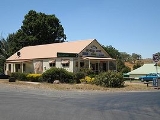
and is home to the Hanging Rock Winery, which is located on Jim Road on the Jim Jim Hill. The area is currently served by the Newham General Store, located on the intersection of Jim Road, Rochford Road, Coach Road and Dons Road, which closed in September 2007 but reopened in June 2009.
Newham has a primary school (State School 1913), a hall (1903) and a park. There is a small, unused bluestone
Bluestone
Bluestone is a cultural or commercial name for a number of dimension or building stone varieties, including:*a feldspathic sandstone in the U.S. and Canada;*limestone in the Shenandoah Valley in the U.S...
church (1868) opposite the school. The Newham Rural Fire Brigade
Newham Rural Fire Brigade
The Newham Rural File Brigade is a volunteer firefighting service located in Newham, Victoria at 1293 Rochford Road. It is often referred to as the Newham CFA. The brigade is part of the Mount Macedon Group in the Lodden-Mallee Region of the Country Fire Authority...
is stationed at Rochford Road.
On 4 December 2009, the modernisations to the 1905 Mechanics' Hall
Mechanics' Institutes
Historically, Mechanics' Institutes were educational establishments formed to provide adult education, particularly in technical subjects, to working men...
were officially opened. This hall is credited with being the birthplace of the Victorian Farmers Union, which later became the Country Party then National Party of Australia.

