
Padre Bernardo
Encyclopedia
| Padre Bernardo | |
|---|---|
| State | Goiás Goiás Goiás is a state of Brazil, located in the central part of the country. The name Goiás comes from the name of an indigenous community... |
| Area: | 3,137.9 km² |
| Population: | 25,969 (IBGE 2007) |
| Elevation: | 629 m above sea level |
| Postcode (CEP): | 73700-000 |
| Became a city: | 1963 |
| Mayor: | Mr. Wayne do Carmo Faria |
| Distance to Goiânia Goiânia -Climate:The city has a tropical wet and dry climate with an average temperature of . There's a wet season, from October to April, and a dry one, from May to September. Annual rainfall is around 1,520 mm.... : |
284 km. |
| IBGE statistical micro-region: | Entorno de Brasília |
| Website: | [www.seplan.go.gov.br/down/planodiretor/PD_PadreBernardo.pdf] |
| Coordinates: | 15°21′16"S 40°30′38"W |
City
A city is a relatively large and permanent settlement. Although there is no agreement on how a city is distinguished from a town within general English language meanings, many cities have a particular administrative, legal, or historical status based on local law.For example, in the U.S...
and municipality
Municipality
A municipality is essentially an urban administrative division having corporate status and usually powers of self-government. It can also be used to mean the governing body of a municipality. A municipality is a general-purpose administrative subdivision, as opposed to a special-purpose district...
north of the Federal District
Federal district
Federal districts are a type of administrative division of a federation, under the direct control of a federal government. They exist in various countries and states all over the world.-United States:...
of Brazil
Brazil
Brazil , officially the Federative Republic of Brazil , is the largest country in South America. It is the world's fifth largest country, both by geographical area and by population with over 192 million people...
in Goiás
Goiás
Goiás is a state of Brazil, located in the central part of the country. The name Goiás comes from the name of an indigenous community...
state, Brazil.
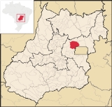
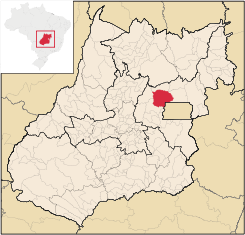
Location
Padre Bernardo is located 42 km. north of the boundary with the Federal District. It has boundaries with the following municipalities:- North: Mimoso de GoiásMimoso de GoiásMimoso de Goiás is a small town and municipality in northeastern Goiás state, Brazil.Mimoso is located in statistical microregion 012, called Entorno de Brasília. It is almost directly north of Brasília and is on an unpaved highway linking Padre Bernardo to Água Fria de Goiás...
- South: Cocalzinho de GoiásCocalzinho de GoiásCocalzinho de Goiás is a small town and municipality in central Goiás state, Brazil.-Location and Geography:Cocalzinho, as it is known by the inhabitants, is located in the micro-region of Entorno de Brasília, on highway BR-414, almost at the junction with highway BR-070...
- East: Planaltina de GoiásPlanaltina de GoiásPlanaltina is a city located in the center of the state of Goiás, Brazil. Planaltina is often referred to as Planaltina de Goiás, but in official documents it is called Planaltina.-Location and Geography:...
- West: Vila PropícioVila PropícioVila Propício is a small town and municipality in central Goiás state, Brazil. It is a large producer of sugarcane.-Location:Vila Propício is located in the Entorno de Brasília micro-region and has boundaries with the following municipalities:...
History
In the mid 30's,pilgrims from the neighboring regions, specially from the Broads of Angicos (Vao dos Angicos), started the tradition of worshiping the Divine Holy Spirit, at the area which was being developed the community/town. In 1951, lands where donated for religious purpose/activities by Mr. Jeronimo de Amorim, who contributed with ten alqueires of land to the Divine Hole Spirit (Catholic Church), where today it is located the little Church of the Divine (Igrejinha do Divino). However, the greatest contribution to the creation and development of the city, was given by the Professor Jose Monteiro Lima. Hence, in 1957, the urban nucleus was founded by the professor, Mr. JOSE MONTEIRO LIMA, whose divided his farm, the Barro Alto farm, in lots, donating it to the poor/ families with financial difficulties, and selling it to the ones who wanted to live in that region, with the finality/goal to give the great push for the emancipation of the district. This occupation developed about 12 kilometer south of the Maranhao River, on the shores/streams of the Barro Alto creek. The name Padre Bernardo was official in 1955, named after and in recognition to the work of to the catholic priest of Luziânia, Bernardo Stocker, a German missioner, who often visited the new city to conduct weddings ceremonies, baptize, and ministry the religious necessities of the bernardian (people from Padre Bernardo) population. Padre Bernard Stocker died in 1955 and is buried in a chapel at the city of Luziania-GO. In 1963, by a project law, authorship by the State of Goias Legislative Representant, Mr. Olinto Meireles, and by the Goias state law number 4797, the district was elevated to the category of Municipality, being part of the judiciary county of Luziania. That law was approved on the 9th day of may of 1964. (Goias State Law number 4797, 05/09/64). The history of Padre Bernardo, Goias is written in its original in Portuguese and it is a Municipal Law and anyone can get a free copy of it at the Town of Padre Bernardo-Goias city Council (Camara Municipal de Padre Bernardo). (Translated by Helton Monteiro-Neves(nevesh@aol.com))The Economy
The main economic activities are cattle raising and growing of corn and soybeans. Local commerce, with restaurants, bars, clothing and shoe shops, banks, supermarkets, among others, supply the basic necessities of the population. There are small industries of brick making, milk produces and clothing manufacturing. The largest employer in the town was the government. There were 02 bank branches in August 2007.In 2006 there were 137,000 head of cattle. The main agricultural products were rice, bananas, sugarcane, beans, coconuts, oranges, lemons, manioc, corn, and soybeans (11,000 hectares in 2006). Seplan
Agricultural data 2006
- Farms: 1,113
- Total area: 198,109 ha.
- Area of permanent crops: 1,462 ha.
- Area of perennial crops: 31,490 ha.
- Area of natural pasture: 124,040 ha.
- Area of woodland and forests: 35,582 ha.
- Persons dependent on farming: 3,400
- Number of tractors: 318
- Cattle herd: 137,000 IBGE
Health and Education
In 2006 there were 26 schools with 8,495 students enrolled. The literacy rate was 0.82.6% in 2000. In 2007 there was 01 hospital with 27 beds. The infant mortality rate was 30.06 in 2000. The Municipal Human Development IndexHuman Development Index
The Human Development Index is a composite statistic used to rank countries by level of "human development" and separate "very high human development", "high human development", "medium human development", and "low human development" countries...
rating was 0.705 in 2000. Seplan
- State ranking: 204 (out of 242 municipalities)
- National ranking: 2,909 (out of 5,507 municipalities) For the complete list see Frigoletto.com