

Pimpirev Beach
Encyclopedia
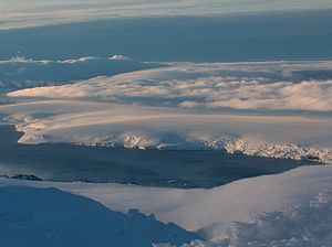
South Bay, Livingston Island
South Bay is a wide bay indenting for the south coast of Livingston Island in the South Shetland Islands, Antarctica. The bay is lying northwest of False Bay and east of Walker Bay, and is entered between Hannah Point and Miers Bluff....
, Livingston Island, Antarctica bounded to the southwest by Ereby Point
Ereby Point
Ereby Point is a point lying 4.5 mi east-northeast of Hannah Point along the north side of South Bay, Livingston Island in the South Shetland Islands, Antarctica. The name Erebys Bay was applied to South Bay on a 1825 chart by James Weddell, Ereby Point was applied by the UK-APC in 1961 in...
and to the northeast by the north corner of the bay marked by an ice sea cave located 5.8 km east-northeast of Ereby Point and 1.45 km northwest of Aleko Point
Aleko Point
Aleko Point , also Aleko Rock, is a rocky point midway along the northeast Antarctic coast of Emona Anchorage in the east of Livingston Island, projecting 150m to the west of southwest....
.
The shoreline, extending 6.5 km in a west-southwest to east-northeast direction, is formed by a narrow beach under the Pimpirev Glacier
Pimpirev Glacier
Pimpirev Glacier on Livingston Island drains southeastwards towards Pimpirev Beach. It is situated west of Perunika Glacier, south of Tundzha Glacier and the glacial divide between the Drake Passage and Bransfield Strait, and east of Kamchiya Glacier...
’s terminus; a number of minor disruptions occur with segments of the ice cap penetrating the sea. Featuring Smolyan Point
Smolyan Point
Smolyan Point is located on the north-western coast of South Bay, Livingston Island in the South Shetland Islands, Antarctica forming the northwest side of the entrance to Emona Anchorage. The ice-covered point shows conspicuous radial crevasses spreading inland and ends up with a 25 m wide and 4...
, a cape located 1.9 km northeast of Ereby Point and ending up with a 25 m wide and 4 m high rock, with conspicuous radial crevasses spreading inland. The central portion of the coast is indented for 250 m by a nameless 710 m wide cove behind Rongel Reef
Rongel Reef
Rongel Reef , is a moraine reef in the Emona Anchorage in the eastern parts of Livingston Island in the South Shetland Islands, Antarctica. The reef emerged during a glacier retreat in the late 20th and early 21st centuries....
.
The beach takes its name from the adjacent Pimpirev Ice Wall, respectively Pimpirev Glacier
Pimpirev Glacier
Pimpirev Glacier on Livingston Island drains southeastwards towards Pimpirev Beach. It is situated west of Perunika Glacier, south of Tundzha Glacier and the glacial divide between the Drake Passage and Bransfield Strait, and east of Kamchiya Glacier...
.
Location
The beach midpoint is located at 62°37′11"S 60°24′50"W (Detailed Spanish mapping in 1991, Bulgarian remapping in 1996, 2005 and 2009 of the coastal configuration modified by recent glacier retreat).Maps
- L.L. Ivanov. Livingston Island: Central-Eastern Region. Scale 1:25000 topographic map. Sofia: Antarctic Place-names Commission of Bulgaria, 1996.
- L.L. Ivanov et al. Antarctica: Livingston Island and Greenwich Island, South Shetland Islands. Scale 1:100000 topographic map. Sofia: Antarctic Place-names Commission of Bulgaria, 2005.
- L.L. Ivanov. Antarctica: Livingston Island and Greenwich, Robert, Snow and Smith Islands. Scale 1:120000 topographic map. Troyan: Manfred Wörner Foundation, 2009. ISBN 978-954-92032-6-4