Rabbit Islands, Scotland
Encyclopedia

Sutherland
Sutherland is a registration county, lieutenancy area and historic administrative county of Scotland. It is now within the Highland local government area. In Gaelic the area is referred to according to its traditional areas: Dùthaich 'IcAoidh , Asainte , and Cataibh...
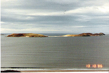
, Scotland in Tongue Bay. In Scottish Gaelic, and occasionally in English, they are known as Eileanan nan Gall, which is sometimes anglicised as "Eilean-na-Gaeil" http://www.electricscotland.com/history/gazetteer/vol5page233.htm or "Eilean nan Gaill".
Geography and geology
The islands' modern name derives from their sandy soil, which favours rabbitRabbit
Rabbits are small mammals in the family Leporidae of the order Lagomorpha, found in several parts of the world...
burrows and makes their presence particularly obvious http://www.electricscotland.com/history/gazetteer/vol5page233.htm. They are fairly low lying, slender in shape, and along with the surrounding fjord
Fjord
Geologically, a fjord is a long, narrow inlet with steep sides or cliffs, created in a valley carved by glacial activity.-Formation:A fjord is formed when a glacier cuts a U-shaped valley by abrasion of the surrounding bedrock. Glacial melting is accompanied by rebound of Earth's crust as the ice...
of Tongue Bay, they show the effects of former glaciation. They are made up of sandstone
Sandstone
Sandstone is a sedimentary rock composed mainly of sand-sized minerals or rock grains.Most sandstone is composed of quartz and/or feldspar because these are the most common minerals in the Earth's crust. Like sand, sandstone may be any colour, but the most common colours are tan, brown, yellow,...
.
The northernmost of the group is called Sgeir an Òir, and there is a natural arch
Natural arch
A natural arch or natural bridge is a natural geological formation where a rock arch forms, with an opening underneath. Most natural arches form as a narrow ridge, walled by cliffs, become narrower from erosion, with a softer rock stratum under the cliff-forming stratum gradually eroding out until...
at its north end called "Claigeann na Sgeir" (Bell of the Skerry
Skerry
A skerry is a small rocky island, usually defined to be too small for habitation. It may simply be a rocky reef. A skerry can also be called a low sea stack....
)
They are near Coldbackie
Coldbackie
Coldbackie is a crofting township in Sutherland and is in the Scottish council area of Highland Scotland.-Geography:Coldbackie lies at the head of the Kyle of Tongue, two miles north east of Tongue. It sits under the Watch Hill, looking north over a spectacular beach to the Rabbit Islands...
, Melness
Melness
Melness is a locality, comprising a group of small remote crofting townships, lying to the west of Tongue Bay opposite Coldbackie, in the north coast of Sutherland, Scottish Highlands and is in the Scottish council area of Highland. The individual hamletsare...
and Talmine on the mainland, and Eilean nan Ròn
Eilean nan Ròn
Eilean nan Ròn is an island near Skerray, in the north of Sutherland, Scotland. 350 seal pups are born here annually.-History:Eilean nan Ròn was populated for many years, with seventy three people living there in 1881 and 30 in 1931. It has been uninhabited since 1938...
is to the north east. They are in the parish of Tongue
Tongue
The tongue is a muscular hydrostat on the floors of the mouths of most vertebrates which manipulates food for mastication. It is the primary organ of taste , as much of the upper surface of the tongue is covered in papillae and taste buds. It is sensitive and kept moist by saliva, and is richly...
.http://www.electricscotland.com/history/gazetteer/vol5page233.htm
History
The islands' older name "Eileanan nan Gall", means "islands of the strangers", or "NorsemenNorsemen
Norsemen is used to refer to the group of people as a whole who spoke what is now called the Old Norse language belonging to the North Germanic branch of Indo-European languages, especially Norwegian, Icelandic, Faroese, Swedish and Danish in their earlier forms.The meaning of Norseman was "people...
".
Supposedly, a ship carrying gold to Charles Edward Stuart
Charles Edward Stuart
Prince Charles Edward Louis John Casimir Sylvester Severino Maria Stuart commonly known as Bonnie Prince Charlie or The Young Pretender was the second Jacobite pretender to the thrones of Great Britain , and Ireland...
was wrecked on the island. The northernmost of the group is called Sgeir an Òir (skerry of the gold), which is perhaps a reference to this.
Currently, the islands are popular with scuba divers, and have in the past been used for grazing.

