

River Frome, Bristol
Encyclopedia
The River Frome is a river
, approximately 20 miles (32.2 km) long, which rises in Dodington Park
, South Gloucestershire
, and flows in a south westerly direction through Bristol
, joining the former course of the river Avon in Bristol's Floating Harbour
. The mean flow at Frenchay
is 60 cuft/s The name Frome is shared with several other rivers in South West England
and means 'fair, fine, brisk’. The river is familiarly known in east Bristol as the Danny.
Originally the Frome joined the Avon downstream of Bristol Bridge
, and formed part of the city defences, but in the thirteenth century the river was diverted through marshland belonging to St Augustine's Abbey
(now Bristol Cathedral), as part of major port improvement works. In the late nineteenth and early twentieth centuries, the lower reaches of the river were culvert
ed and the river now flows under The Centre
into St Augustine's Reach.
As with many urban rivers
, the Frome has suffered from pollution
, but several stretches run through parks and reserves that sustain a range of wildlife. The power of the waters were harnessed in many watermill
s and the area around the river mouth was developed as shipyard
s by the eighteenth century. As the city of Bristol developed, in the nineteenth and twentieth century flooding became a major problem, remedied by the construction of storm drain
s and diversions.
in the Cotswolds
of South Gloucestershire
, flows through Chipping Sodbury
in a north westerly direction through Yate
, and is then joined by the Nibley brook on the left at Nibley. The river turns south towards the next settlement of Frampton Cotterell
, where it is met by the Ladden brook on the right bank. Continuing southwards between Yate and Winterbourne
, the Frome crosses Winterbourne Down, to Damsons Bridge where the Folly brook tributary merges on the left bank.
The Bradley brook joins on the right bank at Hambrook
just before the river passes underneath the M5 motorway
. The Frome now enters a more urban environment passing between Frenchay
on the right and Bromley Heath and Downend
on the left. Turning in a more south westerly direction the river enters Oldbury Court estate, a city park
also known as Vassal's, past Snuff Mills
, entering a steep valley at Stapleton
, then passing Eastville park, where it feeds the former boating lake and is met by the Fishponds brook on the right.
The river then flows under the M32 motorway
and parallels its course for a while before disappearing into an underground culvert just above Baptist Mills. It is joined underground by Coombe brook on the left and Horfield brook on the right. A brief stretch in St Judes is uncovered and then the river runs underneath Broadmead to Broad weir. From there the course carries on underneath Bond Street, through Lewin's Mead
and under the city centre before emerging into St Augustine's Reach near the Watershed Media Centre
.
) to Snuff Mills
the river is navigable, but only by canoe (kayak) though some portaging
may be required. It's also possible to start at Moorend Bridge or Frenchay Bridge . Some of the Bradley Brook has also been kayaked.
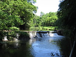
and Stapleton
the river drops nearly 50 feet (15.2 m), and as a result there a number of corn and other mills were established to harness the water power. They were undershot mills with no mill pond
s. Today a wheel at Snuff Mills
is preserved and the mill buildings of Cleeve Mill survive as a private residence.
The Frome originally flowed east of its present-day course from Stone Bridge (now underground by St John's Gate) along the line of St Stephen's Street and Baldwin Street, joining the Avon near Bristol Bridge
. The narrow strip of high land between the two rivers was a naturally strategic place for the Saxon town of Brigstow, later the walled centre of the city, to develop. When Robert, 1st Earl of Gloucester
, rebuilt Bristol Castle
, the Frome was diverted (at present-day Broad Weir) to form the castle moat, so that the city was entirely surrounded by water.
In the mid thirteenth century the harbour had become so busy that it was decided to divert the Frome into a new course through a marsh belonging to St Augustine's Abbey
into a "Deep Ditch" that was dug from Stone Bridge to join the Avon at the present site of Prince Street bridge. This has been the line of the river ever since, known as St Augustine's Reach.
The Floating Harbour
was constructed in 1809, isolating the Avon and Frome from tides between Cumberland Basin
and Totterdown Lock. The increasing use of the Frome as an open sewer combined with the loss of the scouring action of the tides meant that it was now becoming a health hazard and in 1825 it was again diverted, with locks at Stone House, channelling the main flow through Mylne's Culvert to the tidal Avon at New Cut. Up to 1858 the Frome was open along its whole length, and crossed by some 13 bridges. During the latter half of the 19th century, a culvert was built from Wade Street in St Judes to Stone Bridge, covering this stretch completely: Rupert Street and Fairfax Street run over this culverted section. St Augustine's Trench from Stone Bridge to Draw Bridge (near the end of Baldwin Street) was covered over in 1893 and finally the rest of the Trench was covered over in 1938.
began on the River Frome near its mouth in Bristol at least by the 17th century, with Francis Baylie
building warship
s at Narrow Quay. Tombs' Dock
was built opposite at Dean's Marsh in 1760, the builders including FW Green
, and two additional docks were built by at Teast
's Docks in 1790. The last shipbuilder closed in 1883.
, meaning 'fair, fine, brisk’. It is not to be confused with other rivers in the south west of England
with the same name. The historic spelling, Froom, is still sometimes used and this is how the name of the river is pronounced (as in broom). In the nineteenth and twentieth century the River Frome became known in East Bristol as the Danny. The derivation of this name is uncertain, some suggest a nickname, taken from the Blue Danube Waltz
, others that is was derived from the Australian slang
word dunny
.
The Environment Agency in 2008 classified the river as Grade A (highest grade) for chemical content, but the biology was assessed at C grade (mid). Measurements were taken over a stretch of river between Bradley Brook and Broomhill.
 Where it passes through Bristol the river was prone to flooding, but the Northern Stormwater Interceptor, running from Eastville Sluices to the River Avon downstream of Clifton Suspension Bridge, has since been constructed to control this. At Wade Street, St Judes, the river enters an underground culvert
, emerging at what Bristol
ians call The Centre
(formerly the 'Tramways Centre'), but only when there is a risk of flooding. The river is otherwise channelled through Mylne's Culvert into the River Avon at a point between Bathurst Basin and Gaol Ferry Bridge. Three further flood relief tunnels- Castle Ditch, Fosseway and Castle Green Tunnel - run under Castle Park
in central Bristol to carry excess flows into the Floating Harbour.
Major floods have included Mina Road, St Werburghs and Wellington Road in October 1882; Eastville
, St Werburghs and Broadmead in 1936 and 1937; Eastville Park
and nearby due to melting snow in 1947; 1968 Bristol Rovers F.C.
old ground at Eastville. The Broadmead area still remains at risk of flooding in severe weather conditions.
is a public footpath, 18 miles (29 km) long, that runs almost the entire length of the river from Old Sodbury
to Bristol
. A guide pamphlet has been published. The walkway was created by a partnership between local authorities, the Environment Agency, wildlife organisations and location action groups, including Avon Biodiversity Partnership, Avon Invasive Weeds Forum, Avon Wildlife Trust, Bristol City Council, Bristol Naturalists' Society and South Gloucestershire Council. Regular events include clearing of invasive species
and guided walks.
s, wild service trees, dippers
and several species of bats. One of the last British populations of the endangered native white-clawed crayfish
in the Bristol area was found in the river, but became extinct in 2008.
River
A river is a natural watercourse, usually freshwater, flowing towards an ocean, a lake, a sea, or another river. In a few cases, a river simply flows into the ground or dries up completely before reaching another body of water. Small rivers may also be called by several other names, including...
, approximately 20 miles (32.2 km) long, which rises in Dodington Park
Dodington Park
Dodington Park is a country house and estate in Dodington, Gloucestershire, England.The Codrington family acquired the estate in the late 16th century, when there was a large gables Elizabethan house and adjoining church...
, South Gloucestershire
South Gloucestershire
South Gloucestershire is a unitary district in the ceremonial county of Gloucestershire, in South West England.-History:The district was created in 1996, when the county of Avon was abolished, by the merger of former area of the districts of Kingswood and Northavon...
, and flows in a south westerly direction through Bristol
Bristol
Bristol is a city, unitary authority area and ceremonial county in South West England, with an estimated population of 433,100 for the unitary authority in 2009, and a surrounding Larger Urban Zone with an estimated 1,070,000 residents in 2007...
, joining the former course of the river Avon in Bristol's Floating Harbour
Bristol Harbour
Bristol Harbour is the harbour in the city of Bristol, England. The harbour covers an area of . It has existed since the 13th century but was developed into its current form in the early 19th century by installing lock gates on a tidal stretch of the River Avon in the centre of the city and...
. The mean flow at Frenchay
Frenchay
Frenchay is a suburb of Bristol, England, to the north east of the city, but located mainly in South Gloucestershire and the Civil Parish of Winterbourne....
is 60 cuft/s The name Frome is shared with several other rivers in South West England
South West England
South West England is one of the regions of England defined by the Government of the United Kingdom for statistical and other purposes. It is the largest such region in area, covering and comprising Bristol, Gloucestershire, Somerset, Dorset, Wiltshire, Devon, Cornwall and the Isles of Scilly. ...
and means 'fair, fine, brisk’. The river is familiarly known in east Bristol as the Danny.
Originally the Frome joined the Avon downstream of Bristol Bridge
Bristol Bridge
Bristol Bridge is an old bridge over the floating harbour in Bristol, England, the original course of the River Avon.-History:Bristol's name is derived from the Saxon 'Brigstowe' or 'place of the bridge', but it is unclear when the first bridge over the Avon was built. The Avon has the 2nd highest...
, and formed part of the city defences, but in the thirteenth century the river was diverted through marshland belonging to St Augustine's Abbey
Bristol Cathedral
The Cathedral Church of the Holy and Undivided Trinity is the Church of England cathedral in the city of Bristol, England, and is commonly known as Bristol Cathedral...
(now Bristol Cathedral), as part of major port improvement works. In the late nineteenth and early twentieth centuries, the lower reaches of the river were culvert
Culvert
A culvert is a device used to channel water. It may be used to allow water to pass underneath a road, railway, or embankment. Culverts can be made of many different materials; steel, polyvinyl chloride and concrete are the most common...
ed and the river now flows under The Centre
The Centre, Bristol
The Centre is a partially pedestrianised public open space in the central area of Bristol, England, created by covering over the River Frome. The northern end of The Centre is a paved area circuited by Colston Avenue; the southern end is separated from this by a major road junction and is a larger...
into St Augustine's Reach.
As with many urban rivers
Urban stream
An urban stream is a formerly natural waterway that flows through a heavily populated area. Urban streams are often significantly polluted, due to urban runoff and combined sewer outflows....
, the Frome has suffered from pollution
Water pollution
Water pollution is the contamination of water bodies . Water pollution occurs when pollutants are discharged directly or indirectly into water bodies without adequate treatment to remove harmful compounds....
, but several stretches run through parks and reserves that sustain a range of wildlife. The power of the waters were harnessed in many watermill
Watermill
A watermill is a structure that uses a water wheel or turbine to drive a mechanical process such as flour, lumber or textile production, or metal shaping .- History :...
s and the area around the river mouth was developed as shipyard
Shipyard
Shipyards and dockyards are places which repair and build ships. These can be yachts, military vessels, cruise liners or other cargo or passenger ships. Dockyards are sometimes more associated with maintenance and basing activities than shipyards, which are sometimes associated more with initial...
s by the eighteenth century. As the city of Bristol developed, in the nineteenth and twentieth century flooding became a major problem, remedied by the construction of storm drain
Storm drain
A storm drain, storm sewer , stormwater drain or drainage well system or simply a drain or drain system is designed to drain excess rain and ground water from paved streets, parking lots, sidewalks, and roofs. Storm drains vary in design from small residential dry wells to large municipal systems...
s and diversions.
Course
20 miles (32.2 km) long, the River Frome rises in the grounds of Dodington ParkDodington Park
Dodington Park is a country house and estate in Dodington, Gloucestershire, England.The Codrington family acquired the estate in the late 16th century, when there was a large gables Elizabethan house and adjoining church...
in the Cotswolds
Cotswolds
The Cotswolds are a range of hills in west-central England, sometimes called the Heart of England, an area across and long. The area has been designated as the Cotswold Area of Outstanding Natural Beauty...
of South Gloucestershire
South Gloucestershire
South Gloucestershire is a unitary district in the ceremonial county of Gloucestershire, in South West England.-History:The district was created in 1996, when the county of Avon was abolished, by the merger of former area of the districts of Kingswood and Northavon...
, flows through Chipping Sodbury
Chipping Sodbury
Chipping Sodbury is a market town in the county of South Gloucestershire, south-west England, founded in the 12th century by William Crassus . The villages of Old Sodbury and Little Sodbury are nearby...
in a north westerly direction through Yate
Yate
Yate is a town in South Gloucestershire, England, at the southwest extremity of the Cotswold Hills, 12 miles northeast of the city of Bristol. At the 2001 census the population was 21,789. The town of Chipping Sodbury is continuous with Yate to the east...
, and is then joined by the Nibley brook on the left at Nibley. The river turns south towards the next settlement of Frampton Cotterell
Frampton Cotterell
Frampton Cotterell is a village and parish, in South Gloucestershire, south west England on the River Frome. The village is continuous with Winterbourne to the south-west and Coalpit Heath to the east. The parish borders Iron Acton to the north and Westerleigh to the south-east, the large town of...
, where it is met by the Ladden brook on the right bank. Continuing southwards between Yate and Winterbourne
Winterbourne, Gloucestershire
Winterbourne is a large village in South Gloucestershire, England. It had a population of 8,623 in the 2001 census. It sits as the centre of the Civil Parish of Winterbourne which encompasses the neighbouring communities of Winterbourne Down, Hambrook and Frenchay...
, the Frome crosses Winterbourne Down, to Damsons Bridge where the Folly brook tributary merges on the left bank.
The Bradley brook joins on the right bank at Hambrook
Hambrook
Hambrook is a village in South Gloucestershire, England, just outside the outskirts of the city of Bristol. It lies between the two larger communities of Winterbourne and Frenchay and is part of the Civil Parish of Winterbourne...
just before the river passes underneath the M5 motorway
M5 motorway
The M5 is a motorway in England. It runs from a junction with the M6 at West Bromwich near Birmingham to Exeter in Devon. Heading south-west, the M5 runs east of West Bromwich and west of Birmingham through Sandwell Valley...
. The Frome now enters a more urban environment passing between Frenchay
Frenchay
Frenchay is a suburb of Bristol, England, to the north east of the city, but located mainly in South Gloucestershire and the Civil Parish of Winterbourne....
on the right and Bromley Heath and Downend
Downend, South Gloucestershire
Downend is a suburb of Bristol in South Gloucestershire, England. It is located to the North East of Bristol and bordered by the Bristol City suburb of Fishponds to its south west and the South Gloucestershire suburbs of Staple Hill to the south, Frenchay to the west and Mangotsfield to the East...
on the left. Turning in a more south westerly direction the river enters Oldbury Court estate, a city park
Parks of Bristol
The English city of Bristol has a number of parks and public open spaces.-Large parks:Bristol City Council own or manage four major parks: The Downs, Blaise Castle, Ashton Court and Stoke Park....
also known as Vassal's, past Snuff Mills
Snuff Mills
Snuff Mills is a park in the Stapleton area of north Bristol, also known as Whitwood Mill.There are pleasant walks along the steep wooded banks of the River Frome, for example to Oldbury Court...
, entering a steep valley at Stapleton
Stapleton, Bristol
Stapleton is an area in the north-eastern suburbs of the city of Bristol, England. The name is colloquially used today to describe the ribbon village along Bell Hill and Park Road in the Frome Valley. It borders Eastville to the South and Begbrook and Frenchay to the North...
, then passing Eastville park, where it feeds the former boating lake and is met by the Fishponds brook on the right.
The river then flows under the M32 motorway
M32 motorway
The M32 is a motorway in South Gloucestershire and Bristol, England. It provides a link from Bristol city centre to the M4 and is part of the Bristol Parkway. At about , it is one of Britain's shortest motorways...
and parallels its course for a while before disappearing into an underground culvert just above Baptist Mills. It is joined underground by Coombe brook on the left and Horfield brook on the right. A brief stretch in St Judes is uncovered and then the river runs underneath Broadmead to Broad weir. From there the course carries on underneath Bond Street, through Lewin's Mead
Lewin's Mead
Lewin's Mead is an area of Bristol, England, part of the city ward of Cabot, in the historic centre of the city, lying just outside of the former medieval town walls. Several old buildings survive, including the Unitarian Chapel constructed in the late 18th century, an old sugar house, now a hotel...
and under the city centre before emerging into St Augustine's Reach near the Watershed Media Centre
Watershed Media Centre
Watershed opened in June 1982 as the United Kingdom's first dedicated media centre. Based in former warehouses on the harbourside at Bristol, it hosts three cinemas, a café/bar, events/conferencing spaces, and office spaces for administrative and creative staff. It occupies the former V and W sheds...
.
Navigation
From Damsons Bridge (Grid ReferenceBritish national grid reference system
The Ordnance Survey National Grid reference system is a system of geographic grid references used in Great Britain, different from using latitude and longitude....
) to Snuff Mills
Snuff Mills
Snuff Mills is a park in the Stapleton area of north Bristol, also known as Whitwood Mill.There are pleasant walks along the steep wooded banks of the River Frome, for example to Oldbury Court...
the river is navigable, but only by canoe (kayak) though some portaging
Portage
Portage or portaging refers to the practice of carrying watercraft or cargo over land to avoid river obstacles, or between two bodies of water. A place where this carrying occurs is also called a portage; a person doing the carrying is called a porter.The English word portage is derived from the...
may be required. It's also possible to start at Moorend Bridge or Frenchay Bridge . Some of the Bradley Brook has also been kayaked.
History
Between FrenchayFrenchay
Frenchay is a suburb of Bristol, England, to the north east of the city, but located mainly in South Gloucestershire and the Civil Parish of Winterbourne....
and Stapleton
Stapleton, Bristol
Stapleton is an area in the north-eastern suburbs of the city of Bristol, England. The name is colloquially used today to describe the ribbon village along Bell Hill and Park Road in the Frome Valley. It borders Eastville to the South and Begbrook and Frenchay to the North...
the river drops nearly 50 feet (15.2 m), and as a result there a number of corn and other mills were established to harness the water power. They were undershot mills with no mill pond
Mill pond
A mill pond is any body of water used as a reservoir for a water-powered mill. Mill ponds were often created through the construction of a mill dam across a waterway. In many places, the common proper name Mill Pond name has remained even though the mill has long since gone...
s. Today a wheel at Snuff Mills
Snuff Mills
Snuff Mills is a park in the Stapleton area of north Bristol, also known as Whitwood Mill.There are pleasant walks along the steep wooded banks of the River Frome, for example to Oldbury Court...
is preserved and the mill buildings of Cleeve Mill survive as a private residence.
The Frome originally flowed east of its present-day course from Stone Bridge (now underground by St John's Gate) along the line of St Stephen's Street and Baldwin Street, joining the Avon near Bristol Bridge
Bristol Bridge
Bristol Bridge is an old bridge over the floating harbour in Bristol, England, the original course of the River Avon.-History:Bristol's name is derived from the Saxon 'Brigstowe' or 'place of the bridge', but it is unclear when the first bridge over the Avon was built. The Avon has the 2nd highest...
. The narrow strip of high land between the two rivers was a naturally strategic place for the Saxon town of Brigstow, later the walled centre of the city, to develop. When Robert, 1st Earl of Gloucester
Robert, 1st Earl of Gloucester
Robert Fitzroy, 1st Earl of Gloucester was an illegitimate son of King Henry I of England. He was called "Rufus" and occasionally "de Caen", he is also known as Robert "the Consul"...
, rebuilt Bristol Castle
Bristol Castle
Bristol Castle was a Norman castle built for the defence of Bristol. Remains can be seen today in Castle Park near the Broadmead Shopping Centre, including the sally port.-History:...
, the Frome was diverted (at present-day Broad Weir) to form the castle moat, so that the city was entirely surrounded by water.
In the mid thirteenth century the harbour had become so busy that it was decided to divert the Frome into a new course through a marsh belonging to St Augustine's Abbey
Bristol Cathedral
The Cathedral Church of the Holy and Undivided Trinity is the Church of England cathedral in the city of Bristol, England, and is commonly known as Bristol Cathedral...
into a "Deep Ditch" that was dug from Stone Bridge to join the Avon at the present site of Prince Street bridge. This has been the line of the river ever since, known as St Augustine's Reach.
The Floating Harbour
Bristol Harbour
Bristol Harbour is the harbour in the city of Bristol, England. The harbour covers an area of . It has existed since the 13th century but was developed into its current form in the early 19th century by installing lock gates on a tidal stretch of the River Avon in the centre of the city and...
was constructed in 1809, isolating the Avon and Frome from tides between Cumberland Basin
Cumberland Basin (Bristol)
The Cumberland Basin is the main entrance to the docks of the city of Bristol, England. It separates the areas of Hotwells from the tip of Spike Island.The River Avon never flowed through the Cumberland Basin...
and Totterdown Lock. The increasing use of the Frome as an open sewer combined with the loss of the scouring action of the tides meant that it was now becoming a health hazard and in 1825 it was again diverted, with locks at Stone House, channelling the main flow through Mylne's Culvert to the tidal Avon at New Cut. Up to 1858 the Frome was open along its whole length, and crossed by some 13 bridges. During the latter half of the 19th century, a culvert was built from Wade Street in St Judes to Stone Bridge, covering this stretch completely: Rupert Street and Fairfax Street run over this culverted section. St Augustine's Trench from Stone Bridge to Draw Bridge (near the end of Baldwin Street) was covered over in 1893 and finally the rest of the Trench was covered over in 1938.
Shipbuilding
ShipbuildingShipbuilding
Shipbuilding is the construction of ships and floating vessels. It normally takes place in a specialized facility known as a shipyard. Shipbuilders, also called shipwrights, follow a specialized occupation that traces its roots to before recorded history.Shipbuilding and ship repairs, both...
began on the River Frome near its mouth in Bristol at least by the 17th century, with Francis Baylie
Francis Baylie
Francis Baylie was a shipbuilder based in Bristol, England, during the 17th century, a well established merchant shipbuilder who also built warships for the English Royal Navy.- History :-Origins:...
building warship
Warship
A warship is a ship that is built and primarily intended for combat. Warships are usually built in a completely different way from merchant ships. As well as being armed, warships are designed to withstand damage and are usually faster and more maneuvrable than merchant ships...
s at Narrow Quay. Tombs' Dock
Dock (maritime)
A dock is a human-made structure or group of structures involved in the handling of boats or ships, usually on or close to a shore.However, the exact meaning varies among different variants of the English language...
was built opposite at Dean's Marsh in 1760, the builders including FW Green
FW Green
Green Shipbuilders were based in Bristol, England, during the 19th century, constructing wooden sailing ships at Wapping on the River Avon from 1814, and later at Tombs' Dock in Dean's Marsh and the Butts on the Frome....
, and two additional docks were built by at Teast
Sydenham Teast
Sydenham Teast was a shipbuilder and shipowner based in Bristol, England, during the 18th and 19th centuries. Amongst Teast's businesses was whaling, and an ivory and wood trade between England and Africa...
's Docks in 1790. The last shipbuilder closed in 1883.
Etymology
The name derives from the British CelticBrythonic languages
The Brythonic or Brittonic languages form one of the two branches of the Insular Celtic language family, the other being Goidelic. The name Brythonic was derived by Welsh Celticist John Rhys from the Welsh word Brython, meaning an indigenous Briton as opposed to an Anglo-Saxon or Gael...
, meaning 'fair, fine, brisk’. It is not to be confused with other rivers in the south west of England
England
England is a country that is part of the United Kingdom. It shares land borders with Scotland to the north and Wales to the west; the Irish Sea is to the north west, the Celtic Sea to the south west, with the North Sea to the east and the English Channel to the south separating it from continental...
with the same name. The historic spelling, Froom, is still sometimes used and this is how the name of the river is pronounced (as in broom). In the nineteenth and twentieth century the River Frome became known in East Bristol as the Danny. The derivation of this name is uncertain, some suggest a nickname, taken from the Blue Danube Waltz
The Blue Danube
The Blue Danube is the common English title of An der schönen blauen Donau, Op. 314 , a waltz by the Austrian composer Johann Strauss II, composed in 1866...
, others that is was derived from the Australian slang
Australian English vocabulary
Many works giving an overview of Australian English have been published; many of these are humour books designed for tourists or as novelties.One of the first was Karl Lentzner's Dictionary of the Slang-English of Australia and of Some Mixed Languages in 1892. The first dictionary based on...
word dunny
Dunny
Dunny or dunny can is Australian slang for toilet, either the room or the specific fixture, especially an outhouse or other outdoor toilets. It is often used to specify a distinction between a flushing toilet and a non-flushing toilet...
.
Hydrology and flooding
The mean flow as measured at Frampton Cottrell is 60 cuft/s, with a peak on 30 October 2000 of 788 cuft/s and a minimum on 10 August 1990 of 1 cuft/s. The mean flow as measured at Frenchay is 60 cuft/s, with a peak on 10 July 1968 of 2474 cuft/s and a minimum on 9 August 1976 of 2.8 cuft/s.The Environment Agency in 2008 classified the river as Grade A (highest grade) for chemical content, but the biology was assessed at C grade (mid). Measurements were taken over a stretch of river between Bradley Brook and Broomhill.
Culvert
A culvert is a device used to channel water. It may be used to allow water to pass underneath a road, railway, or embankment. Culverts can be made of many different materials; steel, polyvinyl chloride and concrete are the most common...
, emerging at what Bristol
Bristol
Bristol is a city, unitary authority area and ceremonial county in South West England, with an estimated population of 433,100 for the unitary authority in 2009, and a surrounding Larger Urban Zone with an estimated 1,070,000 residents in 2007...
ians call The Centre
The Centre, Bristol
The Centre is a partially pedestrianised public open space in the central area of Bristol, England, created by covering over the River Frome. The northern end of The Centre is a paved area circuited by Colston Avenue; the southern end is separated from this by a major road junction and is a larger...
(formerly the 'Tramways Centre'), but only when there is a risk of flooding. The river is otherwise channelled through Mylne's Culvert into the River Avon at a point between Bathurst Basin and Gaol Ferry Bridge. Three further flood relief tunnels- Castle Ditch, Fosseway and Castle Green Tunnel - run under Castle Park
Castle Park, Bristol
Castle Park is a public open space in Bristol, England, managed by Bristol City Council. It is bounded by the Floating Harbour and Castle Street to the south, Lower Castle Street to the east, and Broad Weir, Newgate and Wine Street to the north...
in central Bristol to carry excess flows into the Floating Harbour.
Major floods have included Mina Road, St Werburghs and Wellington Road in October 1882; Eastville
Eastville, Bristol
Eastville is the name of both a council ward in the city of Bristol in the United Kingdom and a suburb of the city that lies within that ward. The Eastville ward covers the areas of Eastville, Crofts End , Stapleton and part of Fishponds...
, St Werburghs and Broadmead in 1936 and 1937; Eastville Park
Parks of Bristol
The English city of Bristol has a number of parks and public open spaces.-Large parks:Bristol City Council own or manage four major parks: The Downs, Blaise Castle, Ashton Court and Stoke Park....
and nearby due to melting snow in 1947; 1968 Bristol Rovers F.C.
Bristol Rovers F.C.
Bristol Rovers Football Club is an English professional football club, based in Bristol, that competes in Football League Two. The team plays its home matches at the Memorial Stadium, in the Horfield area of the city....
old ground at Eastville. The Broadmead area still remains at risk of flooding in severe weather conditions.
Frome Valley Walkway
The Frome Valley WalkwayFrome Valley Walkway
The Frome Valley Walkway is an 18 mile footpath which follows the River Frome from the River Avon in the centre of Bristol to the Cotswold Hills in South Gloucestershire...
is a public footpath, 18 miles (29 km) long, that runs almost the entire length of the river from Old Sodbury
Old Sodbury
Old Sodbury is a small village in the valley of the River Frome just below and to the west of the Cotswold escarpment and to the east of Chipping Sodbury and Yate in South Gloucestershire, England. The village extends from Chipping Sodbury in the West to the Cotswold Edge in the East and is on the...
to Bristol
Bristol
Bristol is a city, unitary authority area and ceremonial county in South West England, with an estimated population of 433,100 for the unitary authority in 2009, and a surrounding Larger Urban Zone with an estimated 1,070,000 residents in 2007...
. A guide pamphlet has been published. The walkway was created by a partnership between local authorities, the Environment Agency, wildlife organisations and location action groups, including Avon Biodiversity Partnership, Avon Invasive Weeds Forum, Avon Wildlife Trust, Bristol City Council, Bristol Naturalists' Society and South Gloucestershire Council. Regular events include clearing of invasive species
Invasive species
"Invasive species", or invasive exotics, is a nomenclature term and categorization phrase used for flora and fauna, and for specific restoration-preservation processes in native habitats, with several definitions....
and guided walks.
Natural history
The Frome valley supports a range of wildlife and plants, passing through or near to a number of nature reserves and parks, including Goose Green fields, Chill Wood, Cleeve Valley, Oldbury Court park and Eastville Park. Notable species include grey wagtailGrey Wagtail
The Grey Wagtail is a small member of the wagtail family, Motacillidae. The species looks similar to the Yellow Wagtail but has the yellow on its underside restricted to the throat and vent. Breeding males have a black throat...
s, wild service trees, dippers
White-throated Dipper
The White-throated Dipper , also known as the European Dipper or just Dipper is an aquatic passerine bird found in Europe, Middle East, Central Asia and the Indian Subcontinent. The species is divided into several subspecies, based primarily on colour differences, particularly of the pectoral band...
and several species of bats. One of the last British populations of the endangered native white-clawed crayfish
Austropotamobius pallipes
Austropotamobius pallipes is an endangered European freshwater crayfish, and the only species of crayfish native to the British Isles. Its common names include white-clawed crayfish and Atlantic stream crayfish.-Distribution and ecology:...
in the Bristol area was found in the river, but became extinct in 2008.
See also
- Other River FromeFrome (disambiguation)- Relating to the Somerset town :* Frome railway station* Frome Community College* Frome * Somerton and Frome * Frome Town F.C.* Frome Festival-Australia:...
s