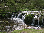
River Lathkill
Encyclopedia

River
A river is a natural watercourse, usually freshwater, flowing towards an ocean, a lake, a sea, or another river. In a few cases, a river simply flows into the ground or dries up completely before reaching another body of water. Small rivers may also be called by several other names, including...
in the Peak District National Park
Peak District
The Peak District is an upland area in central and northern England, lying mainly in northern Derbyshire, but also covering parts of Cheshire, Greater Manchester, Staffordshire, and South and West Yorkshire....
in Derbyshire
Derbyshire
Derbyshire is a county in the East Midlands of England. A substantial portion of the Peak District National Park lies within Derbyshire. The northern part of Derbyshire overlaps with the Pennines, a famous chain of hills and mountains. The county contains within its boundary of approx...
, England
England
England is a country that is part of the United Kingdom. It shares land borders with Scotland to the north and Wales to the west; the Irish Sea is to the north west, the Celtic Sea to the south west, with the North Sea to the east and the English Channel to the south separating it from continental...
.
First recorded in 1280, the name "Lathkill" possibly has Scandinavian roots, the old Norse
Old Norse
Old Norse is a North Germanic language that was spoken by inhabitants of Scandinavia and inhabitants of their overseas settlements during the Viking Age, until about 1300....
hlada-kill translating as "narrow valley with a barn".
Course


Monyash
Monyash is a village in the Derbyshire Peak District about five miles west of Bakewell.Monyash lies at an elevation of 300m above sea level, and has a population of about 280 people. The village is located in a shallow hollow in the limestone plateau at the head of Lathkill Dale, which starts just...
, west of Bakewell
Bakewell
Bakewell is a small market town in the Derbyshire Dales district of Derbyshire, England, deriving its name from 'Beadeca's Well'. It is the only town included in the Peak District National Park, and is well known for the local confection Bakewell Pudding...
, and flows generally eastward past the village of Over Haddon
Over Haddon
Over Haddon is a small village in Derbyshire, England. It is located near the small town of Bakewell, near the B5055 road.Over Haddon overlooks Lathkill Dale and the River Lathkill, which may be crossed by a clapper bridge on a footpath running south from the village. It has two churches, a public...
and through the village of Alport
Alport
Alport is a hamlet in the White Peak area of Derbyshire, England. It lies east of Youlgreave, at the confluence of the River Bradford and the River Lathkill. The oldest house in the hamlet is Monks Hall...
(where it is joined by the River Bradford
River Bradford
The River Bradford is a river in Peak District National Park in England. Its source is near Middleton-by-Youlgrave and after passing below Youlgreave it joins the River Lathkill at Alport...
) until it meets the River Wye
River Wye, Derbyshire
The River Wye is a limestone river in the Peak District of Derbyshire, England. It is in length, and is one of the major tributaries of the River Derwent, which flows into the River Trent, and ultimately into the Humber and the North Sea....
near Rowsley
Rowsley
Rowsley is a village on the A6 road in the English county of Derbyshire.It is at the point where the River Wye flows into the River Derwent and prospered from mills on both.-Overview:...
. Roughly six and a half miles from source to outfall, it is the only river in the district that flows over limestone
Limestone
Limestone is a sedimentary rock composed largely of the minerals calcite and aragonite, which are different crystal forms of calcium carbonate . Many limestones are composed from skeletal fragments of marine organisms such as coral or foraminifera....
for its entire length.
The river valley, known as Lathkill Dale, is popular with tourists who visit to enjoy its natural beauty and wildlife. The medieval Conksbury Bridge now carries the road from Bakewell to Youlgreave
Youlgreave
Youlgreave or Youlgrave is a village in the Derbyshire Peak District, lying on the River Bradford, four kilometres south of Bakewell. Both spellings are used on different local signposts and on different maps. The name possibly derives from "yellow grove" , though was historically called "Giolgrave"...
.
The dale has a history of lead
Lead
Lead is a main-group element in the carbon group with the symbol Pb and atomic number 82. Lead is a soft, malleable poor metal. It is also counted as one of the heavy metals. Metallic lead has a bluish-white color after being freshly cut, but it soon tarnishes to a dull grayish color when exposed...
mining
Mining
Mining is the extraction of valuable minerals or other geological materials from the earth, from an ore body, vein or seam. The term also includes the removal of soil. Materials recovered by mining include base metals, precious metals, iron, uranium, coal, diamonds, limestone, oil shale, rock...
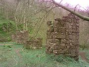
, and among the trees on the north side of the valley can be seen the remains of the 19th century Mandale Mine, including an old aqueduct
Aqueduct
An aqueduct is a water supply or navigable channel constructed to convey water. In modern engineering, the term is used for any system of pipes, ditches, canals, tunnels, and other structures used for this purpose....
and the ruined pump house, used as one of the last attempts to keep the mines drained and workable.
The water in the river is usually unusually clear, and Charles Cotton
Charles Cotton
Charles Cotton was an English poet and writer, best known for translating the work of Michel de Montaigne from the French, for his contributions to The Compleat Angler, and for the highly influential The Compleat Gamester which has been attributed to him.-Early life:He was born at Beresford Hall...
wrote in The Compleat Angler that it is :
Indeed when the river is at its clearest the fish can be seen from one bank across to the other.
Much of the river itself, and sections of the river valley, fall within the Derbyshire Dales National Nature Reserve
Derbyshire Dales NNR
The Derbyshire Dales National Nature Reserve is a series of unconnected limestone dales in the Peak District National Park. It is managed by Natural England and has a permanent staff of wardens who carry out conservation works and ensure the dales are usable for recreation.The dales are:*Lathkill...
. Among the species that thrive there are brown trout
Brown trout
The brown trout and the sea trout are fish of the same species....
, white-throated dippers
White-throated Dipper
The White-throated Dipper , also known as the European Dipper or just Dipper is an aquatic passerine bird found in Europe, Middle East, Central Asia and the Indian Subcontinent. The species is divided into several subspecies, based primarily on colour differences, particularly of the pectoral band...
, and the rare wild plant Jacob's Ladder
Polemonium
Polemonium, commonly called Jacob's ladder, is a genus of about 30 species of flowering plants in the family Polemoniaceae, native to cool temperate to arctic regions of the Northern Hemisphere and also in the southern Andes in South America...
.
Through the use of bluetooth
Bluetooth
Bluetooth is a proprietary open wireless technology standard for exchanging data over short distances from fixed and mobile devices, creating personal area networks with high levels of security...
, it is now possible at particular locations in the Nature Reserve for walkers to download onto their mobile phones pictures of flowers and birds, and also examples of birdsong.
Access
There are car parks at Over Haddon, Moor Lane, Youlgrave and Conksbury Bridge, and bus services run from Over Haddon, Monyash and Youlgreave.See also
- River DoveRiver Dove, DerbyshireThe River Dove is the principal river of the southwestern Peak District, in the Midlands of England and is around in length. It rises on Axe Edge Moor near Buxton and flows generally south to its confluence with the River Trent at Newton Solney. From there, its waters reach the North Sea via the...
- Rivers of the United Kingdom
- Derbyshire lead mining historyDerbyshire lead mining historyThis article details some of the history of lead mining in Derbyshire, England.- Background :On one of the walls in Wirksworth church is a crude stone carving, found nearby at Bonsall and placed in the church in the 1870s. Probably executed in Anglo-Saxon times, it shows a man carrying a kibble or...

