.gif)
Roosevelt Road (Metra)
Encyclopedia
Museum Campus/11th Street (formerly Roosevelt Road) is a commuter rail station in downtown Chicago
that serves the Metra Electric Line
north to Millennium Station and south to University Park
, Blue Island
and South Chicago
; and the South Shore Line
to Gary
and South Bend, Indiana
.
Roosevelt Road Station was located where Roosevelt Road
intersects the former Illinois Central Railroad
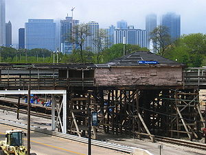
line. The station was the former commuter platforms of Central Station, the long-distance IC passenger terminal that was previously located on this spot. The station structures appeared rickety and run-down, and have since been removed and replaced by a new station located at 11th Street.

CTA Orange
and Green Lines
CTA Buses
Chicago
Chicago is the largest city in the US state of Illinois. With nearly 2.7 million residents, it is the most populous city in the Midwestern United States and the third most populous in the US, after New York City and Los Angeles...
that serves the Metra Electric Line
Metra Electric Line
The Metra Electric District is an electrified commuter rail line owned and operated by Metra which connects Millennium Station in downtown Chicago, with the city's southern suburbs...
north to Millennium Station and south to University Park
University Park, Illinois
University Park is a village in Will County, Illinois. A very small parcel is in Cook County. University Park has been the home of Governors State University since 1969...
, Blue Island
Blue Island, Illinois
Blue Island is a city in Cook County, Illinois. The population was 22,556 at the 2010 census. Blue Island was established in the 1830s as a way station for settlers traveling on the Vincennes Trace, and the settlement prospered because it was conveniently situated a day's journey outside of Chicago...
and South Chicago
South Chicago, Chicago
South Chicago, formerly known as Ainsworth, is one of the 77 well-defined community areas of Chicago, Illinois.This chevron-shaped community is one of Chicago's 16 lakefront neighborhoods near the southern rim of Lake Michigan 10 miles south of downtown...
; and the South Shore Line
South Shore Line (NICTD)
The South Shore Line is an electrically powered interurban commuter rail line operated by the Northern Indiana Commuter Transportation District between Millennium Station in downtown Chicago and the South Bend Regional Airport in South Bend, Indiana...
to Gary
Gary, Indiana
Gary is a city in Lake County, Indiana, United States. The city is in the southeastern portion of the Chicago metropolitan area and is 25 miles from downtown Chicago. The population is 80,294 at the 2010 census, making it the seventh-largest city in the state. It borders Lake Michigan and is known...
and South Bend, Indiana
South Bend, Indiana
The city of South Bend is the county seat of St. Joseph County, Indiana, United States, on the St. Joseph River near its southernmost bend, from which it derives its name. As of the 2010 Census, the city had a total of 101,168 residents; its Metropolitan Statistical Area had a population of 316,663...
.
Roosevelt Road Station was located where Roosevelt Road
Roosevelt Road
Roosevelt Road is a major east-west thoroughfare in the city of Chicago, Illinois, and its western suburbs. It is 1200 South in the city's street numbering system, but only one mile south of Madison Street...
intersects the former Illinois Central Railroad
Illinois Central Railroad
The Illinois Central Railroad , sometimes called the Main Line of Mid-America, is a railroad in the central United States, with its primary routes connecting Chicago, Illinois with New Orleans, Louisiana and Birmingham, Alabama. A line also connected Chicago with Sioux City, Iowa...
line. The station was the former commuter platforms of Central Station, the long-distance IC passenger terminal that was previously located on this spot. The station structures appeared rickety and run-down, and have since been removed and replaced by a new station located at 11th Street.

Bus and rail connections
CTA Red LineRed Line (Chicago Transit Authority)
The northern terminus of the Red Line is Howard Street in the Rogers Park neighborhood of Chicago , on the City Limits farthest north. The Red Line extends southeasterly on an elevated embankment structure about a half-mile west of the lakefront to Touhy Avenue then turns south along Glenwood...
- Roosevelt/State (CTA)Roosevelt/State (CTA)Roosevelt is a subway station on the Chicago Transit Authority's 'L' system, located in Chicago, Illinois, and serving the Red Line. Free transfers to the Orange Line and Green Line elevated station of Roosevelt are available at this station. It is situated at 1167 S State Street, just north of...
CTA Orange
Orange Line (Chicago Transit Authority)
The Orange Line, is a rapid transit line in Chicago, Illinois run by the Chicago Transit Authority as part of the 'L' system. It is approximately long, and runs below grade and elevated on existing railroad embankments and new concrete and steel structures from Chicago Midway International...
and Green Lines
Green Line (Chicago Transit Authority)
The Green Line is part of the CTA rapid transit system known as the Chicago 'L'. It is the only completely elevated route in the 'L' system. It utilizes the system's oldest segments , extending with 29 stops between Forest Park and Oak Park , through Chicago's Loop, to the South Side and Englewood...
- Roosevelt/Wabash (CTA)Roosevelt/Wabash (CTA)Roosevelt is an 'L' station on the CTA's Green and Orange Lines. It is an elevated station with a single island platform, located at 22 East Roosevelt Road in the Near South Side community area of Chicago, just east of State Street....
CTA Buses
-
#1 Indiana/Hyde Park -
#3 King Drive -
#4 Cottage Grove (Owl Service) -
#12 Roosevelt -
#129 West Loop/South Loop -
#130 Museum Campus (Summer Service Only) -
#146 Inner Drive/Michigan Express

