
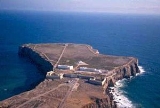
Sagres
Encyclopedia

Promontory
Promontory may refer to:*Promontory, a prominent mass of land which overlooks lower lying land or a body of water*Promontory, Utah, the location where the United States first Transcontinental Railroad was completed...
located in the southwest Algarve region of southern Portugal
Portugal
Portugal , officially the Portuguese Republic is a country situated in southwestern Europe on the Iberian Peninsula. Portugal is the westernmost country of Europe, and is bordered by the Atlantic Ocean to the West and South and by Spain to the North and East. The Atlantic archipelagos of the...
. Only 4 km to the west and 3 km to the north lies Cape St. Vincent
Cape St. Vincent
Cape St. Vincent , next to the Sagres Point, on the so-called Costa Vicentina , is a headland in the municipality of Sagres, in the Algarve, southern Portugal.- Description :This cape is the southwesternmost point in Portugal...
which is usually taken as the southwesternmost tip of Europe. The vicinity of Sagres Point and Cape St. Vincent has been used for religious purposes since Neolithic
Neolithic
The Neolithic Age, Era, or Period, or New Stone Age, was a period in the development of human technology, beginning about 9500 BC in some parts of the Middle East, and later in other parts of the world. It is traditionally considered as the last part of the Stone Age...
times, to which standing menhirs near Vila do Bispo
Vila do Bispo
Vila do Bispo is a municipality in Portugal with a total area of 179.0 km² and a total population of 5,381 inhabitants.The municipality is composed of 5 parishes, and is located in the District of Faro...
, a few miles from both points, attest.
History
The promontory of Sagres has always been important for sailors because it offers a shelter for ships before attempting the dangerous voyage around Cape St. Vincent (could be Belixe Bay, between Sagres Point and the Cape, or Sagres Bay, to the east). Given the dangers of being blown onto the coastal rocks, captains preferred to wait in the lee of the point until favourable winds allowed them to continue.Strabo
There is some question whether Sagres Point, whose name derives from Sacrum Promontorium, or neighboring Cape St. VincentCape St. Vincent
Cape St. Vincent , next to the Sagres Point, on the so-called Costa Vicentina , is a headland in the municipality of Sagres, in the Algarve, southern Portugal.- Description :This cape is the southwesternmost point in Portugal...
, was the ancient sacred promontory. Strabo
Strabo
Strabo, also written Strabon was a Greek historian, geographer and philosopher.-Life:Strabo was born to an affluent family from Amaseia in Pontus , a city which he said was situated the approximate equivalent of 75 km from the Black Sea...
believed the promontory was the most westerly point of the "whole inhabited world." In fact Cape St. Vincent is more westerly, but because it is further north, and Strabo's map of the Iberian Peninsula
Iberian Peninsula
The Iberian Peninsula , sometimes called Iberia, is located in the extreme southwest of Europe and includes the modern-day sovereign states of Spain, Portugal and Andorra, as well as the British Overseas Territory of Gibraltar...
is rotated clockwise, bringing the Pyrenees
Pyrenees
The Pyrenees is a range of mountains in southwest Europe that forms a natural border between France and Spain...
into a north-south line, it could have been taken as further east. The most westerly point of the Iberian peninsula
Iberian Peninsula
The Iberian Peninsula , sometimes called Iberia, is located in the extreme southwest of Europe and includes the modern-day sovereign states of Spain, Portugal and Andorra, as well as the British Overseas Territory of Gibraltar...
and of the European continent is Cabo da Roca
Cabo da Roca
Cabo da Roca is a cape which forms the westernmost extent of mainland Portugal and continental Europe...
, near Sintra
Sintra
Sintra is a town within the municipality of Sintra in the Grande Lisboa subregion of Portugal. Owing to its 19th century Romantic architecture and landscapes, becoming a major tourist centre, visited by many day-trippers who travel from the urbanized suburbs and capital of Lisbon.In addition to...
; the southernmost, Punta de Tarifa
Punta de Tarifa
Punta de Tarifa is the southernmost point of the Iberian Peninsula and continental Europe. It is located in the province of Cádiz and the autonomous community of Andalusia on the Atlantic end of the Straits of Gibraltar. The coast of Morocco can be seen from this point....
, in Andalusia
Andalusia
Andalusia is the most populous and the second largest in area of the autonomous communities of Spain. The Andalusian autonomous community is officially recognised as a nationality of Spain. The territory is divided into eight provinces: Huelva, Seville, Cádiz, Córdoba, Málaga, Jaén, Granada and...
.
Strabo says that Artemidorus
Artemidorus
Artemidorus Daldianus or Ephesius was a professional diviner who lived in the 2nd century. He is known from an extant five-volume Greek work the Oneirocritica, .-Life and work:...
mentions three islands protecting places of anchorage at the point. No part of Cape St. Vincent fits this description, but on the eastern side of Sagres Point is a harbor (Sagres Harbor, port of the modern town of Sagres) with ancient structures protected by four small islands in a line (the tiny Martinhal Islets). They are not usually shown on maps but are visible in satellite imagery. These islands, says Strabo, are ship-shaped.
Strabo also says that Artemidorus reports there were no temples on the sacred promontory, but only stones. According to the custom, these balanced stones must be rotated by visitors, a libation
Libation
A libation is a ritual pouring of a liquid as an offering to a god or spirit or in memory of those who have died. It was common in many religions of antiquity and continues to be offered in various cultures today....
poured, and the stones rotated to their original positions. No sacrifices were allowed. Night trespasses were not allowed, when the gods were believed to be present. No water was available, but must be brought from the neighboring village.
Henry the Navigator
When InfanteInfante of Portugal
Infante of Portugal is the royal title of the Kingdom of Portugal, granted to the sons or daughters of the King and Princes of Portugal who were not the heir to the throne. It is also used to denote a grandson or granddaughter in the male line of a reigning monarch. Female consorts of Infantes of...
Dom
Dom (title)
Dom is a title of respect prefixed to the given name. It derives from Latin Dominus.It is used in English for certain Benedictine and Carthusian monks, and for members of certain communities of Canons Regular. Examples include Benedictine monks of the English Benedictine Congregation...
Henry the Navigator commenced his explorations, which would initiate the Portuguese Age of Discoveries, at his Vila do Infante, Sagres peninsula
Peninsula
A peninsula is a piece of land that is bordered by water on three sides but connected to mainland. In many Germanic and Celtic languages and also in Baltic, Slavic and Hungarian, peninsulas are called "half-islands"....
lacked the necessary requirements for such large undertakings. Fresh water was scarce, agriculture was minimal, there was a shortage of wood for shipbuilding, no deep-water landing site, and the population was small. Henry re-populated a village called Terçanabal, which had been deserted due to continuous pirate attacks on the coast. The village was situated in a strategic position for his maritime enterprises and was later called Vila do Infante.
Henry the Navigator employed cartographers, such as Jehuda Cresques
Jehuda Cresques
Jehuda Cresques , also known as Jafudà Cresques, Jaume Riba, and Cresques lo Juheu was a Catalan cartographer, and was once believed to be the man who coordinated the discoveries of the Portuguese naval school at Sagres in the early 15th century.Son of Abraham Cresques, a famous Jewish...
, to help him chart the coast of Mauretania
Mauretania
Mauretania is a part of the historical Ancient Libyan land in North Africa. It corresponds to present day Morocco and a part of western Algeria...
in the wake of voyages he had caused to made to there. He also engaged an expert map and instrument-maker, Jayme of Majorca, so that his captains might have the best nautical information. This probably led to the legend of the Nautical School of Sagres (although a "school" also means a group of followers). There was no centre of navigational science or any supposed observatory
Observatory
An observatory is a location used for observing terrestrial or celestial events. Astronomy, climatology/meteorology, geology, oceanography and volcanology are examples of disciplines for which observatories have been constructed...
, if compared to the modern definition of "observatory" or "navigational centre", as Russell makes very clear. The centre of his expeditions was actually at Lagos
Lagos, Portugal
Lagos is a municipality at the mouth of Bensafrim River and along the Atlantic Ocean, in the Barlavento region of the Algarve, in southern Portugal....
, further to the east along the Algarve coast. Later Portuguese voyages left from Belém
Santa Maria de Belém
Santa Maria de Belém, or just Belém , whose name is derived from the Portuguese word for Bethlehem, is a civil parish of the municipality of Lisbon, in central Portugal...
, just west of Lisbon.
Cartography
Cartography is the study and practice of making maps. Combining science, aesthetics, and technique, cartography builds on the premise that reality can be modeled in ways that communicate spatial information effectively.The fundamental problems of traditional cartography are to:*Set the map's...
was being refined with the use of newly devised instruments
Measuring instrument
In the physical sciences, quality assurance, and engineering, measurement is the activity of obtaining and comparing physical quantities of real-world objects and events. Established standard objects and events are used as units, and the process of measurement gives a number relating the item...
, such as an improved astrolabe
Astrolabe
An astrolabe is an elaborate inclinometer, historically used by astronomers, navigators, and astrologers. Its many uses include locating and predicting the positions of the Sun, Moon, planets, and stars, determining local time given local latitude and longitude, surveying, triangulation, and to...
and improved sundial
Sundial
A sundial is a device that measures time by the position of the Sun. In common designs such as the horizontal sundial, the sun casts a shadow from its style onto a surface marked with lines indicating the hours of the day. The style is the time-telling edge of the gnomon, often a thin rod or a...
, maps
MAPS
Maps is the plural of map, a visual representation of an area.As an acronym, MAPS may refer to:* Mail Abuse Prevention System, an organisation that provides anti-spam support...
were regularly being updated and extended, and a revolutionary type of vessel
Ship
Since the end of the age of sail a ship has been any large buoyant marine vessel. Ships are generally distinguished from boats based on size and cargo or passenger capacity. Ships are used on lakes, seas, and rivers for a variety of activities, such as the transport of people or goods, fishing,...
known as the caravel
Caravel
A caravel is a small, highly maneuverable sailing ship developed in the 15th century by the Portuguese to explore along the West African coast and into the Atlantic Ocean. The lateen sails gave her speed and the capacity for sailing to windward...
was designed.
Prince Henry built a chapel next to his house in 1459, as he began to spend more time in the Sagres area in his later years. He died at Sagres on 13 November 1460.
The exact location of Henry’s School of Navigation is not known (it is popularly believed to have been destroyed by the 1755 Lisbon earthquake
1755 Lisbon earthquake
The 1755 Lisbon earthquake, also known as the Great Lisbon Earthquake, was a megathrust earthquake that took place on Saturday 1 November 1755, at around 9:40 in the morning. The earthquake was followed by fires and a tsunami, which almost totally destroyed Lisbon in the Kingdom of Portugal, and...
).
General description
The 16th century bulwark-like fortress was severely damaged during the Great Earthquake of 1755. It was restored in the mid 20th century, but there is still a 16th century turretTurret
In architecture, a turret is a small tower that projects vertically from the wall of a building such as a medieval castle. Turrets were used to provide a projecting defensive position allowing covering fire to the adjacent wall in the days of military fortification...
present. After passing through the thick tunnel entrance, one sees a giant pebble compass rose
Compass rose
A compass rose, sometimes called a windrose, is a figure on a compass, map, nautical chart or monument used to display the orientation of the cardinal directions — North, East, South and West - and their intermediate points. It is also the term for the graduated markings found on the traditional...
(Rosa dos Ventos) of 43 m diameter. Normally compass roses are divided into 32 segments, but strangely this one has 40 segments (probably an error of the 20th-century restorers). It is unlikely to date back to the time of Henry the Navigator.
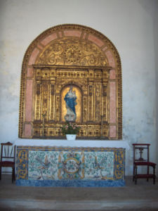
The much-restored church Nossa Senhora da Graça dates from 1579. It replaced the original church of Infante Dom Henrique of 1459. It was also damaged by the earthquake of 1755. Some alterations to the church were made, such as the building of a new bell tower over the old charnel house of the cemetery. There are still a set of tombstones present. Inside this unpretentious church, the 17th century Baroque retable
Retable
A retable is a framed altarpiece, raised slightly above the back of the altar or communion table, on which are placed the cross, ceremonial candlesticks and other ornaments....
above the altar originates from the Capela de Santa Catarina do Forte de Belixe (St. Catherine's Chapel in Belixe Fortress), while the polychrome statues of St. Vincent and St. Francis were once part of the Franciscan convent on the Cape St. Vincent.
Next to the church stands a replica stone standard (padrão
Padrão
A padrão was a large stone cross inscribed with the coat of arms of Portugal that was placed as part of a land claim by numerous Portuguese explorers during the Portuguese Age of Discovery...
), used by the explorers to claim a newly discovered territory.
See also
- Pytheas
- Sacred promontory (disambiguation)Sacred promontory (disambiguation)Sacred promontory or sacred cape or holy promontory or cape was a name assigned by the ancient Greeks and Romans to salient promontories extending into large bodies of water at strategic locations, typically containing a temple to the god of the sea. The English translates Latin sacrum promontorium...