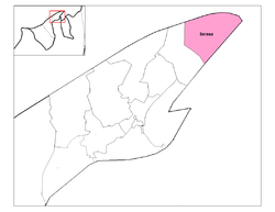
Serasa, Brunei-Muara
Encyclopedia

Mukim
In Brunei, a mukim is a subdivision of a daerah . The equivalent of the word 'mukim' in English would be 'sub-district'.In Malaysia, a mukim can either be a subdivision of a daerah or a subdivision of sub-district, In Singapore, a mukim is one of two varieties of survey...
in the Brunei-Muara district of Brunei
Brunei
Brunei , officially the State of Brunei Darussalam or the Nation of Brunei, the Abode of Peace , is a sovereign state located on the north coast of the island of Borneo, in Southeast Asia...
. It is the easternmost and northernmost mukim
Mukim
In Brunei, a mukim is a subdivision of a daerah . The equivalent of the word 'mukim' in English would be 'sub-district'.In Malaysia, a mukim can either be a subdivision of a daerah or a subdivision of sub-district, In Singapore, a mukim is one of two varieties of survey...
in the Brunei-Muara district. It contains the largest port in the country - Muara Port
Muara, Brunei
Muara is a town in the Brunei and Muara district, Brunei. It contains the country's only deep-water port. Muara is the Malay word for estuary.-Location:...
. It is bounded by the South China Sea
South China Sea
The South China Sea is a marginal sea that is part of the Pacific Ocean, encompassing an area from the Singapore and Malacca Straits to the Strait of Taiwan of around...
to the north, the Brunei Bay
Brunei Bay
Brunei Bay is the gateway to Brunei and Borneo. It is located 4°45'-5°02'N, 114°58'-115°10'E; east of Bandar Seri Begawan. The Brunei portion of the bay is in two sections separated by a finger of Sarawak about 6km wide at the coast...
to the east and south and Mukim Mentiri to the west.
There are several islands and two sand spits which are contained within Mukim Serasa, they are; Pulau Pelong-Pelongan or Pelong Rocks (in English), Tanjong Pelumpong or Pelumpong Spit (also called the Muara Spit) which is a spit that has been cut and turned into a "man-made" island, the man-made Serasa Spit and the large Pulau Muara Besar.
Areas and divisions
Mukim Serasa contains these following areas:- Pekan MuaraMuara, BruneiMuara is a town in the Brunei and Muara district, Brunei. It contains the country's only deep-water port. Muara is the Malay word for estuary.-Location:...
(Muara Town) centre is immediately adjacent to Serasa. - Kampong Pelumpong includes the area towards Tanjong PelumpongTanjong PelumpongTanjong Pelumpong or the Pelumpong Spit in English is the easternmost point in the Brunei-Muara district of Brunei. Despite its name, it is now an island due to the artificially constructed 50m-wide, 10m-deep Muara cut, which separated the spit from the mainland to provide access to Muara...
. - Kampong Tanjong Batu
- Kampong Serasa is adjacent to Pekan Muara to the south-west. This includes the industrial area, the ferry terminal and Kampong Perpindahan Serasa.
- Kampong Masjid Lama located to the south of Muara TownMuara, BruneiMuara is a town in the Brunei and Muara district, Brunei. It contains the country's only deep-water port. Muara is the Malay word for estuary.-Location:...
centre. - Kampong Sabun is located on the west and north-west, including the military barracks.
- Kampong Kapok is located along Jalan Muara, west of Kampong Serasa.
- Kampong Salar is located along Jalan Muara, south-west of Kampong Pengalayan. (used to be included within Mukim Mentiri)
- Kampong Meragang is located between the Muara-Tutong Highway and Jalan Muara.
- Kampong Bukit Kabun
- Kampong Pengalayan is located along Jalan Muara, south-west of Kampong Kapok.
- Kampong Pulau Muara Besar
- Tanjong PelumpongTanjong PelumpongTanjong Pelumpong or the Pelumpong Spit in English is the easternmost point in the Brunei-Muara district of Brunei. Despite its name, it is now an island due to the artificially constructed 50m-wide, 10m-deep Muara cut, which separated the spit from the mainland to provide access to Muara...
, is located along Jalan Muara, south-west of Kampong Pengalayan
Together, the Muara-Serasa areas form the largest urban conurbation in the mukim.
Other locations
Other locations within the mukim include:- Pulau Muara Besar (Muara Besar Island), the largest island in Brunei.
- Muara Naval Base of the Royal Brunei NavyRoyal Brunei NavyThe Royal Brunei Navy is the naval defence force of Brunei Darussalam. It is a small but relatively well-equipped force whose main responsibility is to conduct search and rescue missions and to deter and defend the Brunei waters against attack mounted by sea-borne forces.The Royal Brunei Navy was...
. - Brooketon CollieryBrooketon CollieryBrooketon Colliery was one of the underground coal mines in Brunei. It is no longer in production and has reverted to its natural state .-Location:The Brooketon Colliery is located in Serasa...
, the former coalCoalCoal is a combustible black or brownish-black sedimentary rock usually occurring in rock strata in layers or veins called coal beds or coal seams. The harder forms, such as anthracite coal, can be regarded as metamorphic rock because of later exposure to elevated temperature and pressure...
mine, now closed. - Serasa Beach, where the Royal Brunei Yacht Club is also located.
- Meragang Beach
- Muara Beach
- Serasa Spit
- Pulau Pelong-Pelongan
- The Muara CutTanjong PelumpongTanjong Pelumpong or the Pelumpong Spit in English is the easternmost point in the Brunei-Muara district of Brunei. Despite its name, it is now an island due to the artificially constructed 50m-wide, 10m-deep Muara cut, which separated the spit from the mainland to provide access to Muara...
- an artificial channel 30 feet deep to provide access to Muara PortMuara, BruneiMuara is a town in the Brunei and Muara district, Brunei. It contains the country's only deep-water port. Muara is the Malay word for estuary.-Location:...

