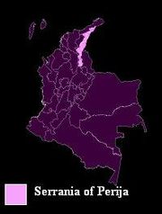
Serrania del Perija
Encyclopedia

Andes
The Andes is the world's longest continental mountain range. It is a continual range of highlands along the western coast of South America. This range is about long, about to wide , and of an average height of about .Along its length, the Andes is split into several ranges, which are separated...
branch (Cordillera Oriental
Cordillera Oriental, Colombia
The Cordillera Oriental is one of three main mountain ranges that divides the Cordillera in the Andes Mountains of Colombia.It extends from southeast to northeast from the "Colombian Massif" in Huila to the Perijá Mountains in La Guajira....
), in northern South America, between Colombia
Colombia
Colombia, officially the Republic of Colombia , is a unitary constitutional republic comprising thirty-two departments. The country is located in northwestern South America, bordered to the east by Venezuela and Brazil; to the south by Ecuador and Peru; to the north by the Caribbean Sea; to the...
and Venezuela
Venezuela
Venezuela , officially called the Bolivarian Republic of Venezuela , is a tropical country on the northern coast of South America. It borders Colombia to the west, Guyana to the east, and Brazil to the south...
, ending further north in the Guajira Desert
La Guajira Desert
La Guajira Desert is located in the northernmost part of Colombia, north of Bogota, in the La Guajira Department, covering most of La Guajira Peninsula including Venezuelan territory. The area holds immense coal reserves, exploited in a zone known as El Cerrejon...
, a total distance of about 310 km. It separates the Maracaibo Basin
Maracaibo Basin
The Maracaibo Basin in Western Venezuela is a prolific, oil-producing sedimentary basin. The basin is bounded on the north by the Oca Fault which separates it from the Caribbean Sea. The remaining sides of the basin are bounded by a branching in the northern Andes Mountains termed the Sierra de...
from the Cesar River
Cesar River
The Cesar River is a river in northern Colombia which is a part of the Magdalena Basin. It separates the Sierra Nevada de Santa Marta from the mountain ranges of the Serrania del Perija an extension of the Cordillera Oriental...
valley.
Geography

Ocaña, Colombia
Ocaña is a town and municipality in the Colombian Department of Norte de Santander. Ocaña is the second largest populated center of this department. It played an important role during the Independence of Colombia from the Spanish monarchy.-History:...
, this mountain range forms the boundary between the Colombian departments of Norte de Santander and Cesar
Cesar Department
Cesar Department or simply Cesar is a department of Colombia located in the north of the country in the Caribbean region, bordering to the north with the Department of La Guajira, to the west with the Department of Magdalena and Department of Bolivar, to the south with Department of Santander, to...
, and then as the range progresses north, it forms the international boundary between Venezuela (Zulia State) and Colombia (Cesar Department). Included in the range are the Sierra Motilones, Sierra Valledupar, and Sierra Oca. The highest point is Cerro de Las Tetas at 3630 meters, followed by Cerro Irapa at 3540 m., Serranía de Macuira
Serranía de Macuira
Serranía de Macuira is a mountain range in northern Colombia located in the municipality of Uribia, Guajira Peninsula and part of the La Guajira Department. The Serrania de Macuira stands in the middle of the La Guajira Desert at 864 meters over sea level, isolated from the mountain ranges of...
at 864 m., and Cerro Aceite at 853 m.
Peoples
The range is 58% in Venezuela, and 42% in Colombia. Venezuela has set aside a substantial part of the central part of the range as a national park (Perijá National Park), and Colombia has a smaller one. In the Venezuelan portion there are Amerindian reservations for the Yucpa and Barí people, and in Colombia for the Iroko and Sokorpa people. Venezuela has started a colonialization border plan building new communities along the border in the Perijá. The town of Cojoro was the first one completed, followed by communities for the WayuuWayuu
Wayuu is an Amerindian ethnic group of the La Guajira Peninsula in northern Colombia and northwest Venezuela. They are part of the Maipurean language family.- Geography :...
and Goajira peoples.
Economy and politics
The climate is mostly tropical humid forests, with cultivation of coffeeCoffee
Coffee is a brewed beverage with a dark,init brooo acidic flavor prepared from the roasted seeds of the coffee plant, colloquially called coffee beans. The beans are found in coffee cherries, which grow on trees cultivated in over 70 countries, primarily in equatorial Latin America, Southeast Asia,...
and papaver
Papaver
Papaver is a genus of 70-100 species of frost-tolerant annuals, biennials, and perennials native to temperate and cold regions of Eurasia, Africa and North America. It is the type genus of the poppy family, Papaveraceae.-Description:...
flowers. It is also a hot spot in the Colombian Conflict serving as home to a northern Caribbean guerrilla front of the FARC, and an ELN
National Liberation Army (Colombia)
National Liberation Army is a revolutionary, avowed Marxist guerrilla group that has been operating in several regions of Colombia since 1964....
guerrilla column, that have also strayed into Venezuelan territory.

