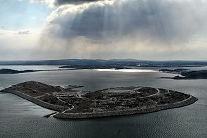
Spectacle Island, Massachusetts
Encyclopedia

Island
An island or isle is any piece of sub-continental land that is surrounded by water. Very small islands such as emergent land features on atolls can be called islets, cays or keys. An island in a river or lake may be called an eyot , or holm...
in Boston Harbor
Boston Harbor
Boston Harbor is a natural harbor and estuary of Massachusetts Bay, and is located adjacent to the city of Boston, Massachusetts. It is home to the Port of Boston, a major shipping facility in the northeast.-History:...
, situated some 4 miles (6.4 km) offshore of downtown Boston, Massachusetts
Massachusetts
The Commonwealth of Massachusetts is a state in the New England region of the northeastern United States of America. It is bordered by Rhode Island and Connecticut to the south, New York to the west, and Vermont and New Hampshire to the north; at its east lies the Atlantic Ocean. As of the 2010...
. The island has a varied history, and today is a public park, forming part of the Boston Harbor Islands National Recreation Area
Boston Harbor Islands National Recreation Area
The Boston Harbor Islands National Recreation Area is a National Recreation Area situated among the islands of Boston Harbor of Boston, Massachusetts. The area is made up of a collection of islands, together with a former island and a peninsula, many of which are open for public recreation and some...
. It is served throughout the year by ferries from Boston, and on weekends and summer weekdays by a shuttle boat to and from the other surrounding islands.
The island was initially composed of two small drumlin
Drumlin
A drumlin, from the Irish word droimnín , first recorded in 1833, is an elongated whale-shaped hill formed by glacial ice acting on underlying unconsolidated till or ground moraine.-Drumlin formation:...
s connected by a spit, with an approximate size of 49 acres (198,296.1 m²). The name is believed to derive from its then-resemblance to a pair of spectacles. However, dumping of trash
Waste
Waste is unwanted or useless materials. In biology, waste is any of the many unwanted substances or toxins that are expelled from living organisms, metabolic waste; such as urea, sweat or feces. Litter is waste which has been disposed of improperly...
and dirt
Soil
Soil is a natural body consisting of layers of mineral constituents of variable thicknesses, which differ from the parent materials in their morphological, physical, chemical, and mineralogical characteristics...
, together with subsequent landscaping, have resulted in a significantly larger island with a permanent size of 85 acres (343,983.1 m²), plus an intertidal zone
Intertidal zone
The intertidal zone is the area that is above water at low tide and under water at high tide . This area can include many different types of habitats, with many types of animals like starfish, sea urchins, and some species of coral...
of a further 28 acres (113,312.1 m²). The island is now composed of two artificial earth mounds, terraced with retaining walls, roads and newly planted vegetation. With a height above sea level
Sea level
Mean sea level is a measure of the average height of the ocean's surface ; used as a standard in reckoning land elevation...
of 157 feet (47.9 m), Spectacle Island is now one of the highest points on Boston Harbor.
History

Native Americans in the United States
Native Americans in the United States are the indigenous peoples in North America within the boundaries of the present-day continental United States, parts of Alaska, and the island state of Hawaii. They are composed of numerous, distinct tribes, states, and ethnic groups, many of which survive as...
used the island as a fishing and clamming spot starting around 600 AD This continued till around 1615, when European diseases killed virtually all of the native population. Europeans began use of the island in the 1630s, first as a source of firewood, then as a smallpox
Smallpox
Smallpox was an infectious disease unique to humans, caused by either of two virus variants, Variola major and Variola minor. The disease is also known by the Latin names Variola or Variola vera, which is a derivative of the Latin varius, meaning "spotted", or varus, meaning "pimple"...
quarantine
Quarantine
Quarantine is compulsory isolation, typically to contain the spread of something considered dangerous, often but not always disease. The word comes from the Italian quarantena, meaning forty-day period....
. From the 1730s, the island housed farmsteads and picnickers.
Starting in the early 19th century, the island was used exclusively for its relative remoteness from Boston. Two hotels were built in 1847, only to be closed by police ten years later when it was discovered they were used for gambling
Gambling
Gambling is the wagering of money or something of material value on an event with an uncertain outcome with the primary intent of winning additional money and/or material goods...
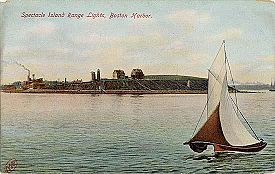
and other illicit activities. In 1897 the Spectacle Island Range Lights
Spectacle Island Range Lights
The Spectacle Island Range Lights were a pair of range lights on Spectacle Island in Boston Harbor. They were established in 1897 and discontinued in 1913 after changes in the entrance channels to the harbor made them obsolete....
were constructed; they were discontinued after changes in the shipping channel in 1913.

Rendering (industrial)
Rendering is a process that converts waste animal tissue into stable, value-added materials. Rendering can refer to any processing of animal byproducts into more useful materials, or more narrowly to the rendering of whole animal fatty tissue into purified fats like lard or tallow...
plant was built in 1857, followed by a city trash incinerator that remained active until 1935. When the incinerator closed, trash was simply dumped on the island for the next thirty years, until a bulldozer was suddenly swallowed up by the trash in 1959. The island remained a smelly, leaking dump until the 1990s.
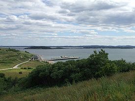
When the Big Dig began work in Boston in 1992, some of the excavated dirt and clay was used to resurface the island. The island was covered and built up by dirt, capped with two feet of clay, and covered with two to five feet of topsoil. Thousands of trees were planted, and paths, buildings, and a dock were built. The island opened to the public in June 2006, for use as a recreational area with hiking trails, a beach, and a marina with boat slips for visitors. It also has a cafe and visitors center.
Transportation
The island is accessible to the public either through a ferry from Long WharfLong Wharf (Boston)
Long Wharf in Boston, Massachusetts "was the busiest pier in the busiest port in America during early colonial times." It extended nearly a half-mile into the harbor, beginning from State Street...
or to private watercraft at the island's marina. Ferries run hourly from and to Boston as well as from and to Georges Island. Ferry connections with Thompson Island
Thompson Island (Massachusetts)
Thompson Island is an island in the Boston Harbor, some 4 miles offshore from downtown Boston, Massachusetts. The island is managed by the Thompson Island Outward Bound Education Center, a non-profit education organization. The island is open to visitors on summer Sundays; otherwise access is by...
are also available.

