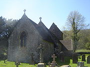
St Brides Netherwent
Encyclopedia

Civil parish
In England, a civil parish is a territorial designation and, where they are found, the lowest tier of local government below districts and counties...
and largely deserted village
Deserted Village
The Feltville Historic District, located in the Watchung Reservation, Union County, New Jersey, is a historical part of this area which still stands to this day. It includes eight houses, a church, a carriage house and a general house. Over the years this "deserted village of Feltville" has become...
in Monmouthshire
Monmouthshire
Monmouthshire is a county in south east Wales. The name derives from the historic county of Monmouthshire which covered a much larger area. The largest town is Abergavenny. There are many castles in Monmouthshire .-Historic county:...
, south east Wales
Wales
Wales is a country that is part of the United Kingdom and the island of Great Britain, bordered by England to its east and the Atlantic Ocean and Irish Sea to its west. It has a population of three million, and a total area of 20,779 km²...
. It is located 2 miles north of Magor
Magor, Monmouthshire
Magor - meaning 'a wall' - is a large village in Monmouthshire, south east Wales, between Chepstow and the city of Newport, and adjoining the Caldicot Levels beside the Severn estuary. Magor lies close to the M4 motorway, which has a nearby motorway service area sharing its name...
, and 3 miles west of Caerwent
Caerwent
Caerwent is a village and community in Monmouthshire, Wales. It is located about five miles west of Chepstow and eleven miles east of Newport, and was founded by the Romans as the market town of Venta Silurum, an important settlement of the Brythonic Silures tribe. The modern village is built...
. The A48
A48 road
The A48 is a major trunk road in Great Britain. It runs from the A40 at Highnam west of Gloucester to the A40 at Carmarthen. Before the construction of the M4 motorway and the first Severn Bridge in the mid 1960s it was the principal route into South Wales. For most of its journey through Wales,...
Newport
Newport
Newport is a city and unitary authority area in Wales. Standing on the banks of the River Usk, it is located about east of Cardiff and is the largest urban area within the historic county boundaries of Monmouthshire and the preserved county of Gwent...
to Chepstow
Chepstow
Chepstow is a town in Monmouthshire, Wales, adjoining the border with Gloucestershire, England. It is located on the River Wye, close to its confluence with the River Severn, and close to the western end of the Severn Bridge on the M48 motorway...
road passes close by to the north.
History
The church of St. Bridget or BrigidBrigid of Kildare
Saint Brigit of Kildare, or Brigit of Ireland , nicknamed Mary of the Gael is one of Ireland's patron saints along with Saints Patrick and Columba...
is set in quiet countryside, adjoining the site of a deserted medieval village
Deserted medieval village
In the United Kingdom, a deserted medieval village is a former settlement which was abandoned during the Middle Ages, typically leaving no trace apart from earthworks or cropmarks. If there are fewer than three inhabited houses the convention is to regard the site as deserted; if there are more...
. It was traditionally founded by Brochwael, the son of Meurig
Meurig ap Tewdrig
Meurig ap Tewdrig was the son of Tewdrig , and a king of the early Welsh kingdoms of Gwent and Glywysing. He is thought to have lived sometime between 400 and 600 AD....
of Gwent, in the 10th century. The church tower dates from the 13th or 14th century, but the body of the church was rebuilt in the 19th century after it became dilapidated.
The parish was part of the medieval lordship of Striguil
Striguil
Striguil or Strigoil is the name which was used from the 11th century until the late 14th century, for the port and Norman castle of Chepstow, on the Welsh side of the River Wye which forms the boundary with England...
. It is so named to distinguish it from the village of St. Brides Wentloog, to the west of Newport
Newport
Newport is a city and unitary authority area in Wales. Standing on the banks of the River Usk, it is located about east of Cardiff and is the largest urban area within the historic county boundaries of Monmouthshire and the preserved county of Gwent...
. "Netherwent" is the English name given from the Norman
Normans
The Normans were the people who gave their name to Normandy, a region in northern France. They were descended from Norse Viking conquerors of the territory and the native population of Frankish and Gallo-Roman stock...
period onwards to the Welsh cantref of Gwent-is-coed (Gwent beneath the wood, i.e. Wentwood
Wentwood
Wentwood is a forested area of hills, rising to 309 metres , in Monmouthshire, South Wales. It is located to the north east of, and partly within the boundaries of, the city of Newport.- Geology :...
), with "-went" deriving from the Roman
Roman Empire
The Roman Empire was the post-Republican period of the ancient Roman civilization, characterised by an autocratic form of government and large territorial holdings in Europe and around the Mediterranean....
town of Venta
Venta Silurum
Venta Silurum was a town in the Roman province of Britannia or Britain. Today it consists of remains in the village of Caerwent in Monmouthshire, south east Wales. Much of it has been archaeologically excavated and is on display to the public....
which became Caerwent.
The village was abandoned in the 18th century.

