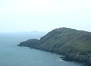
St Davids Head
Encyclopedia


Headland
A headland is a point of land, usually high and often with a sheer drop, that extends out into a body of water.Headland can also refer to:*Headlands and bays*headLand, an Australian television series...
in the Pembrokeshire Coast National Park
Pembrokeshire Coast National Park
Pembrokeshire Coast National Park is a national park along the Pembrokeshire coast in West Wales.It was established as a National Park in 1952, and is the only one in the United Kingdom to have been designated primarily because of its spectacular coastline...
, in southwest Wales
Wales
Wales is a country that is part of the United Kingdom and the island of Great Britain, bordered by England to its east and the Atlantic Ocean and Irish Sea to its west. It has a population of three million, and a total area of 20,779 km²...
. This headland is considered the southern limit of the Irish Sea in Wales.
Northwest of the cathedral city of St David's
St David's
St Davids , is a city and community in Pembrokeshire, Wales. Lying on the River Alun on St David's Peninsula, it is Britain's smallest city in terms of both size and population, the final resting place of Saint David, the country's patron saint, and the de facto ecclesiastical capital of...
and jutting into the Irish Sea
Irish Sea
The Irish Sea separates the islands of Ireland and Great Britain. It is connected to the Celtic Sea in the south by St George's Channel, and to the Atlantic Ocean in the north by the North Channel. Anglesey is the largest island within the Irish Sea, followed by the Isle of Man...
, St Davids Head marks the southern extremity of the large Cardigan Bay
Cardigan Bay
Cardigan Bay is a large inlet of the Irish Sea, indenting the west coast of Wales between Bardsey Island, Gwynedd in the north, and Strumble Head, Pembrokeshire at its southern end. It is the largest bay in Wales....
. To the south are Whitesands Bay, Ramsey Sound
Ramsey Island
Ramsey Island is an island about 1 km off the coast of the St David's peninsula in Pembrokeshire on the northern side of St Brides Bay, in southwest Wales....
and St Brides Bay. The headland and its immediate hinterland
Hinterland
The hinterland is the land or district behind a coast or the shoreline of a river. Specifically, by the doctrine of the hinterland, the word is applied to the inland region lying behind a port, claimed by the state that owns the coast. The area from which products are delivered to a port for...
are owned by the National Trust
National Trust for Places of Historic Interest or Natural Beauty
The National Trust for Places of Historic Interest or Natural Beauty, usually known as the National Trust, is a conservation organisation in England, Wales and Northern Ireland...
.
Described in a Roman
Roman Empire
The Roman Empire was the post-Republican period of the ancient Roman civilization, characterised by an autocratic form of government and large territorial holdings in Europe and around the Mediterranean....
survey of the known world in 140 AD as the 'Promontory of the Eight Perils' there are magnificent views in all directions. To the north, the wide expanse of the Irish Sea
Irish Sea
The Irish Sea separates the islands of Ireland and Great Britain. It is connected to the Celtic Sea in the south by St George's Channel, and to the Atlantic Ocean in the north by the North Channel. Anglesey is the largest island within the Irish Sea, followed by the Isle of Man...
, to the west, the Bishops and Clerks
Bishops and Clerks
The Bishops and Clerks are a group of rocks and islets situated 1 to 2 miles west of Ramsey Island, Pembrokeshire, Wales.They include:*Carreg Rhoson*Carreg-trai*Cribog*Daufraich*Llechau-isaf*Llechau-uchaf*Maen Daufraich*Maen Rhoson*Moelyn...
rocks, to the south, Whitesands Bay to Ramsey Sound and Ramsey Island
Ramsey Island
Ramsey Island is an island about 1 km off the coast of the St David's peninsula in Pembrokeshire on the northern side of St Brides Bay, in southwest Wales....
and to the east, the slopes of the large rocky outcrop known as Carn Llidi.
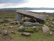
There are a number of ancient monuments showing signs of early occupation, including, an iron age
Iron Age
The Iron Age is the archaeological period generally occurring after the Bronze Age, marked by the prevalent use of iron. The early period of the age is characterized by the widespread use of iron or steel. The adoption of such material coincided with other changes in society, including differing...
cliff fort, prehistoric settlements, a prehistoric defensive wall, signs of various neolithic
Neolithic
The Neolithic Age, Era, or Period, or New Stone Age, was a period in the development of human technology, beginning about 9500 BC in some parts of the Middle East, and later in other parts of the world. It is traditionally considered as the last part of the Stone Age...
field system
Field system
The study of field systems in landscape history is concerned with the size, shape and orientation of a number of fields. These are often adjacent, but may be separated by a later feature.-Types of field system:...
s and Coetan Arthur
Coetan Arthur
Coetan Arthur dolmen, also known as Arthur's Quoit is the remains of a Neolithic burial chamber . It dates from around 3000 BCE...
(Arthur’s Quoit
Dolmen
A dolmen—also known as a portal tomb, portal grave, dolmain , cromlech , anta , Hünengrab/Hünenbett , Adamra , Ispun , Hunebed , dös , goindol or quoit—is a type of single-chamber megalithic tomb, usually consisting of...
) burial chamber.
The headland can only be reached on foot along the coastal path, the nearest road ending at Whitesands bay about a mile to the south-east.
In 1793 Sir Richard Cold Hoare said in his "Journal of a Tour of South Wales":
"No place could ever be more suited to retirement, contemplation or Druidical mysteries, surrounded by inaccessible rock and open to a wide expanse of ocean. Nothing seems wanting but the thick impenetrable groves of oaks which have been thought concomitant to places of Druidical worship and which, from the exposed nature of this situation, would never, I think, have existed here even in former days."
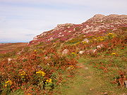
The headland is abundant in wildflowers and wildlife and the waters around it provide a rich habitat for fish, grey seal
Grey Seal
The grey seal is found on both shores of the North Atlantic Ocean. It is a large seal of the family Phocidae or "true seals". It is the only species classified in the genus Halichoerus...
s and porpoises. A wide variety of seabirds and Peregrine Falcons are also to be seen.

