Tara River (Montenegro)
Encyclopedia


Montenegro
Montenegro Montenegrin: Crna Gora Црна Гора , meaning "Black Mountain") is a country located in Southeastern Europe. It has a coast on the Adriatic Sea to the south-west and is bordered by Croatia to the west, Bosnia and Herzegovina to the northwest, Serbia to the northeast and Albania to the...
and Bosnia and Herzegovina
Bosnia and Herzegovina
Bosnia and Herzegovina , sometimes called Bosnia-Herzegovina or simply Bosnia, is a country in Southern Europe, on the Balkan Peninsula. Bordered by Croatia to the north, west and south, Serbia to the east, and Montenegro to the southeast, Bosnia and Herzegovina is almost landlocked, except for the...
. It emerges from the confluence of the Opasnica and Veruša Rivers in the Prokletije
Prokletije
Prokletije or Albanian Alps is a mountain range in the Balkans that extends from northern Albania, to southwestern Serbia and eastern Montenegro. Its highest point, Jezercë in Albania at , is the tallest peak in the entire Dinaric Alps...
mountain, part of Dinaric Alps
Dinaric Alps
The Dinaric Alps or Dinarides form a mountain chain in Southern Europe, spanning areas of Slovenia, Croatia, Bosnia and Herzegovina, Serbia, Kosovo, Albania and Montenegro....
of Montenegro. The total length is 144 km, of which 110 km are in Montenegro, while the final 34 km are in Bosnia and Herzegovina; it also forms the border between the two countries in several places. The Tara flows from south to north - north-west and converges with the Piva at the Bosnia and Herzegovina and Montenegro border between the villages of Šćepan Polje (Montenegro) and Hum (Bosnia and Herzegovina) to form the Drina
Drina
The Drina is a 346 kilometer long river, which forms most of the border between Bosnia and Herzegovina and Serbia. It is the longest tributary of the Sava River and the longest karst river in the Dinaric Alps which belongs to the Danube river watershed...
river.
The Tara River cuts the Tara River Gorge, the longest canyon
Canyon
A canyon or gorge is a deep ravine between cliffs often carved from the landscape by a river. Rivers have a natural tendency to reach a baseline elevation, which is the same elevation as the body of water it will eventually drain into. This forms a canyon. Most canyons were formed by a process of...
in Montenegro and Europe
Europe
Europe is, by convention, one of the world's seven continents. Comprising the westernmost peninsula of Eurasia, Europe is generally 'divided' from Asia to its east by the watershed divides of the Ural and Caucasus Mountains, the Ural River, the Caspian and Black Seas, and the waterways connecting...
and second longest in the world after Grand Canyon
Grand Canyon
The Grand Canyon is a steep-sided canyon carved by the Colorado River in the United States in the state of Arizona. It is largely contained within the Grand Canyon National Park, the 15th national park in the United States...
, at 78 kilometers in length and 1,300 meters at its deepest. The canyon is protected as a UNESCO World Heritage Site, and is a part of Durmitor National Park.
Tara River is not to be confused with Tara Mountain
Tara Mountain
Tara , is a mountain located in western Serbia. It is part of Dinaric Alps and stands at 1,000-1,500 metres above sea level. The mountain's slopes are clad in dense forests with numerous high-altitude clearings and meadows, steep cliffs, deep ravines carved by the nearby Drina River and many karst,...
and Tara National Park, which are situated in western Serbia
Serbia
Serbia , officially the Republic of Serbia , is a landlocked country located at the crossroads of Central and Southeast Europe, covering the southern part of the Carpathian basin and the central part of the Balkans...
.
River Rafting
RaftingRafting
Rafting or white water rafting is a challenging recreational outdoor activity using an inflatable raft to navigate a river or other bodies of water. This is usually done on white water or different degrees of rough water, in order to thrill and excite the raft passengers. The development of this...
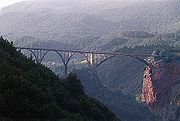
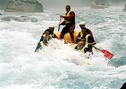
is very popular on Tara River. It is also one of the most popular things to do in Montenegro. The one day rafting route, from Brstnovica to Šćepan Polje is 18 km long and it takes 2 to 3 hours, but most popular is part which included few kilometers of river Drina all together 25 km to Rafting center Drina-Tara. Among the attractions of the area is Đurđevića Tara Bridge, on the crossroads between Mojkovac
Mojkovac
Mojkovac is a town in northern Montenegro. It has a population of 4,120 . Mojkovac is also the centre of the municipality, which has a population of 10,066.-Features:...
, Žabljak
Žabljak
Žabljak is a small town in northern Montenegro. It has a population of 1,937.Žabljak is the seat of the municipality...
and Pljevlja
Pljevlja
Pljevlja is a town and municipality located in the northern part of Montenegro. The city lies at an altitude of...
.
Rafting starts at Splavista from where you start the adventure 100 km long in the most beautiful and exciting part of canyon. Already at the beginning the Tara, the waterfalls of Ljutica are shown and then, you will pass under monumental bridge of the Tara, 165 metres high and then, you come up to the old Roman road and then pass through the. Lever Tara. "Funjički bukovi" and "Bijele ploče" will make you realise how calm and up to this moment nice Tara becomes wild beauty. "Nisovo vrelo" is the deepest part of canyon of 1100 metres high. Further is the bottom of the mountain top, "Curevac" (1650 m), that rises above Tara as its "eternal guardian" and one of the nicest bellevue of Durmitor. Then you end up at the waterfalls of Draga and then pass through the Radovan luka. Then you pass through the "Canyon of Susica", "Tepački bukovi", "Brstanovički bukovi" and "Bailovica sige." Rafting will end at Sćepan Polje.
In 2005, the European Championships in Rafting were held on the Vrbas and the Tara rivers, in the Republika Srpska
Republika Srpska
Republika Srpska is one of two main political entities of Bosnia and Herzegovina, the other being the Federation of Bosnia and Herzegovina...
entity of Bosnia and Herzegovina. According to the International Rafting Federation, the event was hugely successful. In May 2009 the World Rafting Championships were held again in Republika Srpska, on the Vrbas and Tara rivers.
Dam controversy
The governments of Montenegro and Republika SrpskaRepublika Srpska
Republika Srpska is one of two main political entities of Bosnia and Herzegovina, the other being the Federation of Bosnia and Herzegovina...
had plans to flood the Tara River Gorge, with the construction of a hydroelectric dam in the Drina
Drina
The Drina is a 346 kilometer long river, which forms most of the border between Bosnia and Herzegovina and Serbia. It is the longest tributary of the Sava River and the longest karst river in the Dinaric Alps which belongs to the Danube river watershed...
, at Buk Bijela
Buk Bijela Hydro Power Plant
The Buk Bijela Hydro Power Plant should be one of Bosnia and Herzegovina's largest hydro power plant, if built, having an installed electric capacity of 450 MW....
. However, it abandoned this plan in April, 2005 after several successful protests of advocates for the preservation of the canyon. But, in September 2006, a protocol for cooperation between Slovenian company Petrol and Montenegrin company "Montenegro-bonus" was signed, and the building of an electric plant with initial power of 40 or 60 megawatts is planned, despite all efforts to protect the gorge. Also, plans of constructing dams in Bosnia and Herzegovina
Bosnia and Herzegovina
Bosnia and Herzegovina , sometimes called Bosnia-Herzegovina or simply Bosnia, is a country in Southern Europe, on the Balkan Peninsula. Bordered by Croatia to the north, west and south, Serbia to the east, and Montenegro to the southeast, Bosnia and Herzegovina is almost landlocked, except for the...
on the Drina
Drina
The Drina is a 346 kilometer long river, which forms most of the border between Bosnia and Herzegovina and Serbia. It is the longest tributary of the Sava River and the longest karst river in the Dinaric Alps which belongs to the Danube river watershed...
river, some 15 kilometers downstream of confluence of the Tara with the Piva river, are still alive.

