
Dinaric Alps
Encyclopedia
The Dinaric Alps or Dinarides form a mountain chain in Southern Europe
, spanning areas of Slovenia
, Croatia
, Bosnia and Herzegovina
, Serbia
, Kosovo
, Albania
and Montenegro
.
They extend for 645 kilometres (401 mi) along the coast of the Adriatic Sea
(northwest-southeast), from the Julian Alps
in the northwest down to the Šar-Korab
massif
, where the mountain direction changes to north-south. The highest mountain of the Dinaric Alps is MountProkletije
, located on the border of eastern Montenegro and northern Albania, with the peak called "Lake Crest
" at 2692 metres (8,832 ft).
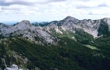
The Dinaric Alps are the fifth most rugged and extensively mountainous area of Europe after the Caucasus Mountains
, Alps
, Pyrenees
and Scandinavian Mountains
. They are formed largely of secondary and tertiary sedimentary rock
s of dolomite
, limestone
, sand
and conglomerates formed by seas and lakes that had once covered the area.
During the Alpine earth movements
that occurred 50–100 million years ago, immense lateral pressures folded and overthrust the rocks in a great arc around the old rigid block of the northeast. The Dinaric Alps were thrown up in more or less parallel ranges, stretching like necklaces from the Julian Alps as far as the areas of northern Albania and Kosovo, where the mountainous terrain subsides to make way for the waters of Drin
and the fields of Kosovo. The Šar and Korab
mountains then rise and the mountainous terrain continues southwards to the Pindus
of Greece
and the mountains of the Peloponnese
and Crete
, Rhodes
to the Taurus Mountains
of southern Turkey
.
(1,913 m), a prominent peak in the center of the mountain range on the border of Croatia and Bosnia and Herzegovina.
The chain is called Alpet Dinaride or Alpet Dinarike in Albanian
, Dinarske planine, Dinarsko gorje or Dinaridi in Croatian
, Dinarske planine (Динарске планине) or Dinaridi (Динариди) in Bosnian
, Montenegrin
, and Serbian
, and Dinarsko gorstvo in Slovene.
 The Mesozoic limestone forms a very distinctive region of the Balkans
, notable for features such as the Karst
, which has given its name to all such terrains of limestone eroded by groundwater. The Quaternary ice ages had relatively little direct geologic influence on the Balkans. No permanent ice cap
s existed, and there is little evidence of extensive glaciation. Only the highest summits of Durmitor, Orjen and Prenj
have glacial valleys and moraine
s as low as 600 m (1,969 ft). However, in the Prokletije, a range on the northern Albanian border that runs east to west (thus breaking the general geographic trend of the Dinaric system), there is evidence of major glaciation.
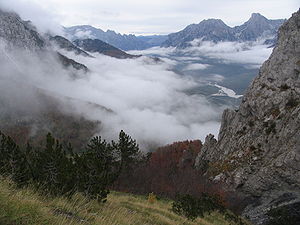
One geological feature of great importance to the present-day landscape of the Dinarides must be considered in more detail: that of the limestone mountains, often with their attendant faulting. They are hard and slow to erode, and often persist as steep jagged escarpments, through which steep-sided gorges and canyon
s are cleft by the rivers draining the higher slopes.
The most extensive example of limestone mountains in Europe are those of the Karst of the Dinaric Alps. Here, all the characteristic features are encountered again and again as one travels through this wild and underpopulated country. Limestone is a very porous rock, yet very hard and resistant to erosion
. Water is the most important corrosive force
, dissolving the limestone by chemical action of its natural acidity. As it percolates down through cracks in the limestone it opens up fissures and channels, often of considerable depth, so that whole systems of underground drainage develop. During subsequent millennia these work deeper, leaving in their wake enormous waterless caverns, sinkhole
s and grotto
es and forming underground labyrinths of channels and shafts. The roofs of some of these caverns may eventually fall in, to produce great perpendicular-sided gorges, exposing the water to the surface once more. The magnificent gorges of many of the Dinaric rivers, for example those of the Vrbas
, Neretva
, Tara
and Lim
, are justly famous. The partially submerged western Dinaric Alps form the numerous island
s and harbours along the Croatian coast.
Only along the Dinaric gorges is communication possible across the Karst, and roads and railways tunnel through precipitous cliffs and traverse narrow ledges above roaring torrents. A number of springs and rivers rise in the Dinaric range, including Jadro Spring
noted for having been the source of water for Diocletian's Palace
at Split. At the same time, the purity of these rocks is such that the rivers are crystal clear, and there is little soil-making residue. Water quality testing of the Jadro River
, for example, indicates the low pollutant
levels present. Rock faces are often bare of vegetation and glaring white, but what little soil there is may collect in the hollows and support lush lime-tolerant vegetation
, or yield narrow strips of cultivation.
resisting Roman
conquest of the Balkans, which began with the conquest of the eastern Adriatic
coast in the 3rd century BC. Rome conquered the whole of Illyria
in 168 BC, but these mountains sheltered Illyrian resistance forces for many years until the area's complete subjugation by 14 AD. More recently, the Ottoman Empire
failed to fully subjugate the mountainous areas of Montenegro. In the 20th century, too, the mountains provided favourable terrain for guerrilla warfare
, with Yugoslav Partisans organising one of the most successful Allied
resistance movements of World War II
.
The area remains underpopulated, and forestry and mining remain the chief economic activities in the Dinaric Alps. The people of the Dinaric Alps are on record as being among the tallest in the world, with a male average height of 185.6 centimetre and a female average height of 171 centimetre.
es of the Dinaric Alps are:
Southern Europe
The term Southern Europe, at its most general definition, is used to mean "all countries in the south of Europe". However, the concept, at different times, has had different meanings, providing additional political, linguistic and cultural context to the definition in addition to the typical...
, spanning areas of Slovenia
Slovenia
Slovenia , officially the Republic of Slovenia , is a country in Central and Southeastern Europe touching the Alps and bordering the Mediterranean. Slovenia borders Italy to the west, Croatia to the south and east, Hungary to the northeast, and Austria to the north, and also has a small portion of...
, Croatia
Croatia
Croatia , officially the Republic of Croatia , is a unitary democratic parliamentary republic in Europe at the crossroads of the Mitteleuropa, the Balkans, and the Mediterranean. Its capital and largest city is Zagreb. The country is divided into 20 counties and the city of Zagreb. Croatia covers ...
, Bosnia and Herzegovina
Bosnia and Herzegovina
Bosnia and Herzegovina , sometimes called Bosnia-Herzegovina or simply Bosnia, is a country in Southern Europe, on the Balkan Peninsula. Bordered by Croatia to the north, west and south, Serbia to the east, and Montenegro to the southeast, Bosnia and Herzegovina is almost landlocked, except for the...
, Serbia
Serbia
Serbia , officially the Republic of Serbia , is a landlocked country located at the crossroads of Central and Southeast Europe, covering the southern part of the Carpathian basin and the central part of the Balkans...
, Kosovo
Kosovo
Kosovo is a region in southeastern Europe. Part of the Ottoman Empire for more than five centuries, later the Autonomous Province of Kosovo and Metohija within Serbia...
, Albania
Albania
Albania , officially known as the Republic of Albania , is a country in Southeastern Europe, in the Balkans region. It is bordered by Montenegro to the northwest, Kosovo to the northeast, the Republic of Macedonia to the east and Greece to the south and southeast. It has a coast on the Adriatic Sea...
and Montenegro
Montenegro
Montenegro Montenegrin: Crna Gora Црна Гора , meaning "Black Mountain") is a country located in Southeastern Europe. It has a coast on the Adriatic Sea to the south-west and is bordered by Croatia to the west, Bosnia and Herzegovina to the northwest, Serbia to the northeast and Albania to the...
.
They extend for 645 kilometres (401 mi) along the coast of the Adriatic Sea
Adriatic Sea
The Adriatic Sea is a body of water separating the Italian Peninsula from the Balkan peninsula, and the system of the Apennine Mountains from that of the Dinaric Alps and adjacent ranges...
(northwest-southeast), from the Julian Alps
Julian Alps
The Julian Alps are a mountain range of the Southern Limestone Alps that stretches from northeastern Italy to Slovenia, where they rise to 2,864 m at Mount Triglav. They are named after Julius Caesar, who founded the municipium of Cividale del Friuli at the foot of the mountains...
in the northwest down to the Šar-Korab
Mount Korab
Mount Korab is the highest mountain of the Republic of Macedonia and Albania, its peak forming a frontier between the two countries...
massif
Massif
In geology, a massif is a section of a planet's crust that is demarcated by faults or flexures. In the movement of the crust, a massif tends to retain its internal structure while being displaced as a whole...
, where the mountain direction changes to north-south. The highest mountain of the Dinaric Alps is MountProkletije
Prokletije
Prokletije or Albanian Alps is a mountain range in the Balkans that extends from northern Albania, to southwestern Serbia and eastern Montenegro. Its highest point, Jezercë in Albania at , is the tallest peak in the entire Dinaric Alps...
, located on the border of eastern Montenegro and northern Albania, with the peak called "Lake Crest
Lake Crest
Maja Jezercë is the highest point of the Prokletije and the entire Dinaric Alps, standing at AMSL.-Location and surroundings:The mountain peak, which is just five kilometres from the border with Montenegro, lies between the valleys of the Valbona to the east and the Shala in the west...
" at 2692 metres (8,832 ft).
The Dinaric Alps are the fifth most rugged and extensively mountainous area of Europe after the Caucasus Mountains
Caucasus Mountains
The Caucasus Mountains is a mountain system in Eurasia between the Black Sea and the Caspian Sea in the Caucasus region .The Caucasus Mountains includes:* the Greater Caucasus Mountain Range and* the Lesser Caucasus Mountains....
, Alps
Alps
The Alps is one of the great mountain range systems of Europe, stretching from Austria and Slovenia in the east through Italy, Switzerland, Liechtenstein and Germany to France in the west....
, Pyrenees
Pyrenees
The Pyrenees is a range of mountains in southwest Europe that forms a natural border between France and Spain...
and Scandinavian Mountains
Scandinavian Mountains
The Scandinavian Mountains or the Scandes, in Swedish Skanderna, Fjällen or Kölen , in Finnish Köli and in Norwegian Kjølen, with the three latter meaning The Keel, are a mountain range that runs through the Scandinavian Peninsula...
. They are formed largely of secondary and tertiary sedimentary rock
Sedimentary rock
Sedimentary rock are types of rock that are formed by the deposition of material at the Earth's surface and within bodies of water. Sedimentation is the collective name for processes that cause mineral and/or organic particles to settle and accumulate or minerals to precipitate from a solution....
s of dolomite
Dolomite
Dolomite is a carbonate mineral composed of calcium magnesium carbonate CaMg2. The term is also used to describe the sedimentary carbonate rock dolostone....
, limestone
Limestone
Limestone is a sedimentary rock composed largely of the minerals calcite and aragonite, which are different crystal forms of calcium carbonate . Many limestones are composed from skeletal fragments of marine organisms such as coral or foraminifera....
, sand
Sand
Sand is a naturally occurring granular material composed of finely divided rock and mineral particles.The composition of sand is highly variable, depending on the local rock sources and conditions, but the most common constituent of sand in inland continental settings and non-tropical coastal...
and conglomerates formed by seas and lakes that had once covered the area.
During the Alpine earth movements
Alpine orogeny
The Alpine orogeny is an orogenic phase in the Late Mesozoic and Tertiary that formed the mountain ranges of the Alpide belt...
that occurred 50–100 million years ago, immense lateral pressures folded and overthrust the rocks in a great arc around the old rigid block of the northeast. The Dinaric Alps were thrown up in more or less parallel ranges, stretching like necklaces from the Julian Alps as far as the areas of northern Albania and Kosovo, where the mountainous terrain subsides to make way for the waters of Drin
Drin River
The Drin is the longest river in Albania with a total length of . It has two distributaries, one going directly into the Adriatic Sea, the other one into the Bojana River .- Origin :...
and the fields of Kosovo. The Šar and Korab
Mount Korab
Mount Korab is the highest mountain of the Republic of Macedonia and Albania, its peak forming a frontier between the two countries...
mountains then rise and the mountainous terrain continues southwards to the Pindus
Pindus
The Pindus mountain range is located in northern Greece and southern Albania. It is roughly 160 km long, with a maximum elevation of 2637 m . Because it runs along the border of Thessaly and Epirus, the Pindus range is often called the "spine of Greece"...
of Greece
Greece
Greece , officially the Hellenic Republic , and historically Hellas or the Republic of Greece in English, is a country in southeastern Europe....
and the mountains of the Peloponnese
Peloponnese
The Peloponnese, Peloponnesos or Peloponnesus , is a large peninsula , located in a region of southern Greece, forming the part of the country south of the Gulf of Corinth...
and Crete
Crete
Crete is the largest and most populous of the Greek islands, the fifth largest island in the Mediterranean Sea, and one of the thirteen administrative regions of Greece. It forms a significant part of the economy and cultural heritage of Greece while retaining its own local cultural traits...
, Rhodes
Rhodes
Rhodes is an island in Greece, located in the eastern Aegean Sea. It is the largest of the Dodecanese islands in terms of both land area and population, with a population of 117,007, and also the island group's historical capital. Administratively the island forms a separate municipality within...
to the Taurus Mountains
Taurus Mountains
Taurus Mountains are a mountain complex in southern Turkey, dividing the Mediterranean coastal region of southern Turkey from the central Anatolian Plateau. The system extends along a curve from Lake Eğirdir in the west to the upper reaches of the Euphrates and Tigris rivers in the east...
of southern Turkey
Turkey
Turkey , known officially as the Republic of Turkey , is a Eurasian country located in Western Asia and in East Thrace in Southeastern Europe...
.
Name
The Dinarides are named after Mount DinaraDinara
Dinara is a mountain located on the border of Croatia and Bosnia and Herzegovina. One of its summits, also called Dinara, is the highest point in Croatia at 1,831 m and a prominence of 728 m.-Etymology:...
(1,913 m), a prominent peak in the center of the mountain range on the border of Croatia and Bosnia and Herzegovina.
The chain is called Alpet Dinaride or Alpet Dinarike in Albanian
Albanian language
Albanian is an Indo-European language spoken by approximately 7.6 million people, primarily in Albania and Kosovo but also in other areas of the Balkans in which there is an Albanian population, including western Macedonia, southern Montenegro, southern Serbia and northwestern Greece...
, Dinarske planine, Dinarsko gorje or Dinaridi in Croatian
Croatian language
Croatian is the collective name for the standard language and dialects spoken by Croats, principally in Croatia, Bosnia and Herzegovina, the Serbian province of Vojvodina and other neighbouring countries...
, Dinarske planine (Динарске планине) or Dinaridi (Динариди) in Bosnian
Bosnian language
Bosnian is a South Slavic language, spoken by Bosniaks. As a standardized form of the Shtokavian dialect, it is one of the three official languages of Bosnia and Herzegovina....
, Montenegrin
Montenegrin language
Montenegrin is a name used for the Serbo-Croatian language as spoken by Montenegrins; it also refers to an incipient standardized form of the Shtokavian dialect of Serbo-Croatian used as the official language of Montenegro...
, and Serbian
Serbian language
Serbian is a form of Serbo-Croatian, a South Slavic language, spoken by Serbs in Serbia, Bosnia and Herzegovina, Montenegro, Croatia and neighbouring countries....
, and Dinarsko gorstvo in Slovene.
Geology
Balkans
The Balkans is a geopolitical and cultural region of southeastern Europe...
, notable for features such as the Karst
KARST
Kilometer-square Area Radio Synthesis Telescope is a Chinese telescope project to which FAST is a forerunner. KARST is a set of large spherical reflectors on karst landforms, which are bowlshaped limestone sinkholes named after the Kras region in Slovenia and Northern Italy. It will consist of...
, which has given its name to all such terrains of limestone eroded by groundwater. The Quaternary ice ages had relatively little direct geologic influence on the Balkans. No permanent ice cap
Ice cap
An ice cap is an ice mass that covers less than 50 000 km² of land area . Masses of ice covering more than 50 000 km² are termed an ice sheet....
s existed, and there is little evidence of extensive glaciation. Only the highest summits of Durmitor, Orjen and Prenj
Prenj
Prenj is a mountain in the Dinaric Alps of southern Bosnia and Herzegovina, located in eastern Herzegovina near Mostar, Jablanica and Konjic. The highest peak is the Zelena glava at , and there are several other peaks of similar height....
have glacial valleys and moraine
Moraine
A moraine is any glacially formed accumulation of unconsolidated glacial debris which can occur in currently glaciated and formerly glaciated regions, such as those areas acted upon by a past glacial maximum. This debris may have been plucked off a valley floor as a glacier advanced or it may have...
s as low as 600 m (1,969 ft). However, in the Prokletije, a range on the northern Albanian border that runs east to west (thus breaking the general geographic trend of the Dinaric system), there is evidence of major glaciation.
One geological feature of great importance to the present-day landscape of the Dinarides must be considered in more detail: that of the limestone mountains, often with their attendant faulting. They are hard and slow to erode, and often persist as steep jagged escarpments, through which steep-sided gorges and canyon
Canyon
A canyon or gorge is a deep ravine between cliffs often carved from the landscape by a river. Rivers have a natural tendency to reach a baseline elevation, which is the same elevation as the body of water it will eventually drain into. This forms a canyon. Most canyons were formed by a process of...
s are cleft by the rivers draining the higher slopes.
The most extensive example of limestone mountains in Europe are those of the Karst of the Dinaric Alps. Here, all the characteristic features are encountered again and again as one travels through this wild and underpopulated country. Limestone is a very porous rock, yet very hard and resistant to erosion
Erosion
Erosion is when materials are removed from the surface and changed into something else. It only works by hydraulic actions and transport of solids in the natural environment, and leads to the deposition of these materials elsewhere...
. Water is the most important corrosive force
Corrosion
Corrosion is the disintegration of an engineered material into its constituent atoms due to chemical reactions with its surroundings. In the most common use of the word, this means electrochemical oxidation of metals in reaction with an oxidant such as oxygen...
, dissolving the limestone by chemical action of its natural acidity. As it percolates down through cracks in the limestone it opens up fissures and channels, often of considerable depth, so that whole systems of underground drainage develop. During subsequent millennia these work deeper, leaving in their wake enormous waterless caverns, sinkhole
Sinkhole
A sinkhole, also known as a sink, shake hole, swallow hole, swallet, doline or cenote, is a natural depression or hole in the Earth's surface caused by karst processes — the chemical dissolution of carbonate rocks or suffosion processes for example in sandstone...
s and grotto
Grotto
A grotto is any type of natural or artificial cave that is associated with modern, historic or prehistoric use by humans. When it is not an artificial garden feature, a grotto is often a small cave near water and often flooded or liable to flood at high tide...
es and forming underground labyrinths of channels and shafts. The roofs of some of these caverns may eventually fall in, to produce great perpendicular-sided gorges, exposing the water to the surface once more. The magnificent gorges of many of the Dinaric rivers, for example those of the Vrbas
Vrbas River
The Vrbas is a major river in western Bosnia and Herzegovina.It is a right tributary of the river Sava. The city of Banja Luka is located on the river banks...
, Neretva
Neretva
Neretva is the largest river of the eastern part of the Adriatic basin. It has been harnessed and controlled to a large extent by four HE power-plants with large dams and their storage lakes, but it is still recognized for its natural beauty, diversity of its landscape and visual...
, Tara
Tara River (Montenegro)
The Tara is a river in Montenegro and Bosnia and Herzegovina. It emerges from the confluence of the Opasnica and Veruša Rivers in the Prokletije mountain, part of Dinaric Alps of Montenegro...
and Lim
Lim River
The Lim is a river flowing through Montenegro, Albania, Serbia and Bosnia and Herzegovina. long, it's the right and the longest tributary of the Drina.- Montenegro and Serbia :...
, are justly famous. The partially submerged western Dinaric Alps form the numerous island
Island
An island or isle is any piece of sub-continental land that is surrounded by water. Very small islands such as emergent land features on atolls can be called islets, cays or keys. An island in a river or lake may be called an eyot , or holm...
s and harbours along the Croatian coast.
Only along the Dinaric gorges is communication possible across the Karst, and roads and railways tunnel through precipitous cliffs and traverse narrow ledges above roaring torrents. A number of springs and rivers rise in the Dinaric range, including Jadro Spring
Jadro Spring
The Jadro Spring is a water source rising in the Dinaric Alps in Croatia. The spring was the original water supply for the ancient city comprised by Diocletian's Palace . Contemporary studies indicate favourable water quality levels at the spring source. The Jadro Spring is the source of the...
noted for having been the source of water for Diocletian's Palace
Diocletian's Palace
Diocletian's Palace is a building in Split, Croatia, that was built by the Roman emperor Diocletian at the turn of the fourth century AD.Diocletian built the massive palace in preparation for his retirement on 1 May 305 AD. It lies in a bay on the south side of a short peninsula running out from...
at Split. At the same time, the purity of these rocks is such that the rivers are crystal clear, and there is little soil-making residue. Water quality testing of the Jadro River
Jadro River
The Jadro River is a watercourse in Dalmatia, Croatia that discharges to the Adriatic Sea. The upper reaches of the Jadro River as well as its source are protected as an ichthyological nature reserve, partly due to the presence of an endemic species of soft-mouthed trout...
, for example, indicates the low pollutant
Pollutant
A pollutant is a waste material that pollutes air, water or soil, and is the cause of pollution.Three factors determine the severity of a pollutant: its chemical nature, its concentration and its persistence. Some pollutants are biodegradable and therefore will not persist in the environment in the...
levels present. Rock faces are often bare of vegetation and glaring white, but what little soil there is may collect in the hollows and support lush lime-tolerant vegetation
Vegetation
Vegetation is a general term for the plant life of a region; it refers to the ground cover provided by plants. It is a general term, without specific reference to particular taxa, life forms, structure, spatial extent, or any other specific botanical or geographic characteristics. It is broader...
, or yield narrow strips of cultivation.
Human activity
Ruins of fortresses dot the mountainous landscape, evidence of centuries of war and the refuge the Dinaric Alps have provided to various armed forces. During the Roman period, the Dinarides provided shelter to the IllyriansIllyrians
The Illyrians were a group of tribes who inhabited part of the western Balkans in antiquity and the south-eastern coasts of the Italian peninsula...
resisting Roman
Ancient Rome
Ancient Rome was a thriving civilization that grew on the Italian Peninsula as early as the 8th century BC. Located along the Mediterranean Sea and centered on the city of Rome, it expanded to one of the largest empires in the ancient world....
conquest of the Balkans, which began with the conquest of the eastern Adriatic
Adriatic Sea
The Adriatic Sea is a body of water separating the Italian Peninsula from the Balkan peninsula, and the system of the Apennine Mountains from that of the Dinaric Alps and adjacent ranges...
coast in the 3rd century BC. Rome conquered the whole of Illyria
Illyria
In classical antiquity, Illyria was a region in the western part of the Balkan Peninsula inhabited by the Illyrians....
in 168 BC, but these mountains sheltered Illyrian resistance forces for many years until the area's complete subjugation by 14 AD. More recently, the Ottoman Empire
Ottoman Empire
The Ottoman EmpireIt was usually referred to as the "Ottoman Empire", the "Turkish Empire", the "Ottoman Caliphate" or more commonly "Turkey" by its contemporaries...
failed to fully subjugate the mountainous areas of Montenegro. In the 20th century, too, the mountains provided favourable terrain for guerrilla warfare
Guerrilla warfare
Guerrilla warfare is a form of irregular warfare and refers to conflicts in which a small group of combatants including, but not limited to, armed civilians use military tactics, such as ambushes, sabotage, raids, the element of surprise, and extraordinary mobility to harass a larger and...
, with Yugoslav Partisans organising one of the most successful Allied
Allies of World War II
The Allies of World War II were the countries that opposed the Axis powers during the Second World War . Former Axis states contributing to the Allied victory are not considered Allied states...
resistance movements of World War II
World War II
World War II, or the Second World War , was a global conflict lasting from 1939 to 1945, involving most of the world's nations—including all of the great powers—eventually forming two opposing military alliances: the Allies and the Axis...
.
The area remains underpopulated, and forestry and mining remain the chief economic activities in the Dinaric Alps. The people of the Dinaric Alps are on record as being among the tallest in the world, with a male average height of 185.6 centimetre and a female average height of 171 centimetre.
Passes
The main mountain passMountain pass
A mountain pass is a route through a mountain range or over a ridge. If following the lowest possible route, a pass is locally the highest point on that route...
es of the Dinaric Alps are:
- Postojna GatePostojna GateThe Postojna Gate , also Adriatic Gate and Italo-Illyrian Gate, is a major mountain pass of the Dinaric Alps. Located in Slovenia, the pass's approximately wide saddle allows for the lowest crossing of the Dinaric Alps, at an elevation of . and a second higher crossing at the Hrušica plateau. It...
(Postojnska vrata), Slovenia (606 m (1,988 ft)), - Vratnik pass, Croatia (850 m (2,789 ft))
- Knin Gate (Kninska vrata) (about 700 m (2,297 ft))
- Vaganj (1137 m (3,730 ft))
- Ivan-Saddle (Ivan-sedlo), Bosnia-Herzegovina (967 m (3,173 ft))
- Cemerno, Bosnia-Herzegovina (1329 m (4,360 ft))
- Crkvine, Montenegro (1045 m (3,428 ft))
- Cakor, Montenegro (1849 m (6,066 ft))
Tunnels
Major tunnels transversing the Dinaric Alps include:- Tuhobić TunnelTuhobic TunnelTuhobić Tunnel is one of the most significant structures on the Croatian A6 motorway route. As it is long , Tuhobić Tunnel is the longest tunnel on the A6 motorway route. The tunnel is located at above sea level, connecting Gorski Kotar and Croatian Littoral regions...
, Croatia - Sveti Rok TunnelSveti Rok TunnelThe Sveti Rok Tunnel is a highway tunnel in Lika, Croatia. It is long and it passes through the Velebit mountain. Sveti Rok Tunnel is located on a part of the between highway exits Sveti Rok and Maslenica on the A1 highway...
, Croatia - Mala Kapela TunnelMala Kapela TunnelMala Kapela Tunnel is the most significant structure on the Croatian A1 motorway route. As it is long , Mala Kapela Tunnel is the longest tunnel in Croatia. The tunnel is geographically located between villages of Jezerane and Modruš , and between Ogulin and Brinje motorway interchanges...
, Croatia
Mountains and plateaus
The mountains and plateaus within the Dinarides are found in the following regions.Albania
|
Maja Hekurave Maja e Hekurave is a mountain in the Prokletije in the country of Albania. At , it is one of the highest peaks in the mountain range. Maja Hekurave is a popular tourist spot.... Maja Tat Maja Tat a mountain at 2,543 m high found in the northern part of Albania in the Prokletije range.Maja Radohimës at 2,570 m high is found close to Maja Tat in its eastern direction. It is known for its steep and dangerous slopes and rocky, limestone summit.... Kolata e Mirë Kolata e Mirë is a mountain in the Kolata massif located in Albania and Montenegro. Kolata e Mirë is a part of the Prokletije and stands at high. It and Zla Kolata which is high are the two peaks of the Kolata massif. Kolata e Mirë is the second highest peak in Montenegro after its neighbour Zla... |
Maja Rosit Rosni Peak is the highest peak of a mountain named Bjelić, located on the border between Albania and Montenegro. It is 2,524 m high, the large mountain in the Prokletije range and the third highest mountain in Montenegro.-External links:... Maja Kokervhake Maja Kokervhake is a mountain in northern Albania, in the Prokletije. It reaches a height of above sea level and it has only recently been discovered considering that the North Albanian Alps has many high and jagged peaks.... Maja Shkurt Maja Shkurt a mountain in northern Albania, part of the Prokletije range. It reaches a height of 2,499m just under 2,500m. The Albanian name Maja Shkurt means 'Small Peak'.... Maja Malësores Maja e Malësores is an impressive mountain in the country of Albania. At high it is located in the central main part of the Prokletije range. Like Maja Popluks, it is also surrounded by many high peaks which are all located in Albania. Deep river canyons and beautiful valleys surround the mountain.... Maja e Ragamit Maja e Ragamit a mountain with a height reaching 2,472m is located in the Prokletije in Albania. Maja e Ragimit is east of Maja Jezercë at 2,694m high which is the highest of the range and the Dinaric Alps.... |
Maja Bojs Maja Bojs is a mountain in the Prokletije of northern Albania reaching a height of . It is close to the border with Montenegro and is just above the Buni Jezerce valley where Big lake of Buni Jezerce is located with 5 other lakes.... Maja Vukoces Maja Vukoces is a mountain in northern Albania in the Prokletije with a height of 2,450m. Like others in the range, it too has a steep, rocky summit. It is even more difficult to climb it at winter when the snow and ice make the route to the peak and summit impossible to reach.... Shkëlzen Shkëlzen is a mountain in Albania with a height of . It is rocky and located near the border with Kosovo, north of Tropojë. It belongs to the Prokletije. Shkëlzen shares its name with a village that is just south of the mountain.... Maja e Kakisë Maja e Kakisë a mountain in the north of Albania. Maja e Kakisë is 2,360m high. It is located in the south of the large Prokletije not far from the smaller Maja e Ershellit which is found even more towards the south bordering the long Drin River.... Rrasa e Zogut Rrasa e Zogut is a mountain in the Prokletije range in Kosovo, from the border with Albania. It is high and located south-east of Đeravica , the highest mountain in Kosovo.-Notes and references:Notes:References:... |
Bosnia and Herzegovina
|
Jahorina Mount Jahorina , is a mountain in south-eastern Bosnia and Herzegovina, located southeast of Sarajevo within Republika Srpska. It borders fellow Olympic mountain Trebević... Javor (Bosnia and Herzegovina) Javor is a mountain in the municipality of Nevesinje, Bosnia and Herzegovina. It has an altitude of .... Kamešnica Kamešnica is a mountain in the Dinarides at the border of Bosnia and Herzegovina and Croatia . It is an extension of the Dinara that stretches from the northwest white road pass Vaganj to Buško Blato artificial lake... Klekovača Klekovača is a mountain in the Dinaric Alps of western Bosnia and Herzegovina, located near Drvar and Bosanski Petrovac. The highest peak is the Velika Klekovača at .... Konjuh Konjuh is a village in the municipality of Kruševac, Serbia. According to the 2002 census, the village has a population of 1139 people.... Kozara Kozara is a mountain in western Bosnia and Herzegovina, in the Bosanska Krajina region. It is bounded by the rivers Sava - north, Vrbas - east, Sana - south and Una - west... Lebršnik Lebršnik is a mountain in the municipality of Gacko, Bosnia and Herzegovina. It has an altitude of .... Lelija Lelija is a mountain within the Sutjeska National Park, Republic of Srpska, Bosnia and Herzegovina. It has an altitude of 2,032 metres .-References:... |
Orjen Orjen is a Dinaric Mediterranean limestone mountain range in Montenegro-Bosnia and Herzegovina. At 1894 m , Zubački kabao is the highest peak in the subadriatic Dinarides. The massif of Orjen lies to the Northwest of Risan in Bay of Kotor... Osječenica Osječenica is a mountain in the municipality of Drvar, Bosnia and Herzegovina. It has an altitude of .... Ozren Ozren is a mountain in northern Bosnia and Herzegovina. It lies between cities of Doboj and Zavidovići, partly in the Republika Srpska and partly in the Federation entity.... Maglic mountain Maglić is the highest peak at an elevation of in the hill ranges of Plješevica, Grmeč, Cincar and Raduša in the country of Montenegro, Opstina Zabljak Province. Maglić borders Bosnia and Montenegro. It is oriented in a northwest-southeast direction.... (with 2,386m the highest peak of BiH) Majevica Majevica is a mountain in north-eastern Bosnia and Herzegovina. It is situated between Semberija, Posavina, and Tuzlanska Kotlina.Its highest peak is Stolice, some 10 miles east of Tuzla, and its stands 916 m high... Motajica -References:... Prenj Prenj is a mountain in the Dinaric Alps of southern Bosnia and Herzegovina, located in eastern Herzegovina near Mostar, Jablanica and Konjic. The highest peak is the Zelena glava at , and there are several other peaks of similar height.... |
Raduša (mountain) Raduša is a mountain in the Dinaric Alps of Bosnia and Herzegovina, located near Gornji Vakuf, spanning the area between Vukovsko polje in the north, the Stožer mountain in the east, the Rama River basin in the south, the Makljen mountain pass in the west, near the source of the Vrbas. The highest... Romanija Romanija is a geographical region in eastern Republika Srpska, Bosnia and Herzegovina. Main towns in the region include Pale, Sokolac, and Han Pijesak.... Trebevic Trebević is a mountain in central Bosnia and Herzegovina. It is found directly to the southeast of Sarajevo, territory of East Sarajevo city, bordering Jahorina mountain. Trebević is 1627 meters tall, making it the second shortest of the Sarajevo mountains.During the Middle Ages, Trebević was... Treskavica Treskavica is a mountain in Bosnia and Herzegovina, situated in Trnovo municipality just south of city of Sarajevo.Mala Ćaba peak at 2088 meters , makes Treskavica the tallest of all the mountains circling Sarajevo, and only some 300 meters shorter than the tallest mountain in the country... Šator Šator is a mountain in the Dinaric Alps, in the western regions of Bosnia and Herzegovina. The name šator means "tent". The highest peak Veliki Šator is a.s.l... Trebava -References:... Velez - Places :* Peñón de Vélez de la Gomera, Spain* Vélez de Benaudalla, Spain* Vélez Sársfield , Buenos Aires, Argentina* Vélez-Blanco, Spain* Vélez-Málaga, Spain* Vélez-Rubio, Spain* Vélez, Santander, Colombia- Sports clubs :... |
Visocica Visočica Visočica Visočica (also known as Brdo Grad (Bosnian: Hill Town) is a hill in Bosnia and Herzegovina famous as the site of the Old town of Visoki as well the recent claim that it is one of the Bosnian pyramids.... Vlasulja Vlasulja is a mountain in the municipality of Foča, Bosnia and Herzegovina. It has an altitude of .... Vlasic Vlasic Pickles is an American brand of pickles currently owned by Pinnacle Foods. Since its introduction in 1942, it has become one of the most popular pickle brands in the United States.-History:... Volujak Volujak is a peak of the Prokletije range in Kosovo, reaching a top height of . Volujak creates part of the Rugova Canyon. This mountain can be seen from the city of Peć because it is only a few kilometers west of it.-Notes and references:Notes:... Vran Vran is a mountain in the municipality of Jablanica, Bosnia and Herzegovina. It has an altitude of .... Vranica Vranica is a mountain in the municipality of Gornji Vakuf, Bosnia and Herzegovina. It has an altitude of .... Zelengora Zelengora is a mountain within the Sutjeska National Park in Bosnia and Herzegovina. It has an altitude of 2,014 metres .... |
Croatia
|
Ucka The Učka is a mountain range that rises behind Opatija riviera, on the Istrian peninsula, in northwestern Croatia. It forms a single morphological unit together with the Čičarija range which streches from the bay of Trieste to Rijeka... Ćićarija Ćićarija is a mountainous plateau in the northern and north-eastern part of Istria peninsula, 45 km long and 10–15 km wide. It mostly lies in Croatia, while its northern part lies in Slovenia... Velebit Velebit is the largest though not the highest mountain range in Croatia. Its highest peak is the Vaganski vrh at 1757 m.The range forms a part of the Dinaric Alps and is located along the Adriatic coast, separating it from Lika in the interior... Svilaja Svilaja is a mountain range in Croatia, located in inland of Dalmatian Zagora.It belongs to Dinaric Alps, and it stretches from the town of Sinj northwest to the Petrovo field, approximate 30 km in length.... Velika Kapela The Velika Kapela is a large mountain range in the east of Gorski Kotar, Croatia.The highest peak is Bjelolasica-Kula at 1533 m.a.s.l.. It overlooks Velebit, Plješivica, islands Krk, Cres, Lošinj, and the Kvarner Gulf.... Mala Kapela Mala Kapela is a mountain in Croatia, part of the Dinaric Alps. It stretches in the direction northwest-southeast, and it extends from the mountain pass called "Kapela" or "Vrh Kapele" that separates it from Velika Kapela, down to the mountain pass that connects Otočac and Plitvice and from then... Žumberak Žumberak or Gorjanci is a range of mountains or hills between Croatia and Slovenia. The highest peak is Sveta Gera on the border between Croatia and Slovenia, being tall.... |
Kosovo
- Đeravica/Gjeravica
- Gusan/Maja GusanitMaja GusanitGusan is a mountain located in Albania and Kosovo. At high, it is the highest mountain that is shared between the two. This mountain belongs to the Prokletije. It is connected by a ridge to Đeravica in Kosovo, which is only a few kilometres south from it....
- Marijaš/MarijashMarijašMarijaš or Bogdaš is a mountain in Kosovo in the Prokletije range. At high, it is the highest peak of the Bogićevica area and one of the highest peaks in Prokletije in Kosovo. The mountain is located near the Montenegrin border....
- Veternik/VeternikuVeternik MountainVeternik or Veterniku is a mountain in Kosovo. It is high and forms part of the Prokletije. It is located nearby Kopranik, a mountain higher than Veternik but also found in the same range. Veternik differs somewhat from the rest of the Prokletije of Kosovo and resembles more the Albanian part of...
- Bogićaj/Maja BogiçajBogicaj (peak)Maja Bogiçaj is a peak of the Prokletije. It is located on the border of Kosovo and Albania. Bogiçaj is part of the Bogićevica mountain area and its peak is above sea level. One of the closest peaks is Tromeđa which is just found north-west of Bogiçaj peak....
- Lićenat/Leqinat
Montenegro
- Bijela goraBijela gorathumb|300px|Cirque Borovi do in the north at Bijela goraBijela gora is a karstic high plateau between 1200–1500 m on the northern side of Orjen in Montenegro. At 1862 m, Velika Jastrebica is the highest summit...
means "White Mountain" in Montenegrin, which is the opposite of "Crna Gora" or "Black Mountain" which is the local name for Montenegro - DurmitorDurmitorDurmitor is a massif and the name of a national park in North Western Montenegro. It reaches a height of 2,522 m .The massif is bordered by Tara River Canyon on the North, Piva River Canyon on the West, and by Komarnica River Canyon on the South. To the East, Durmitor is open to a vast ...
- OrjenOrjenOrjen is a Dinaric Mediterranean limestone mountain range in Montenegro-Bosnia and Herzegovina. At 1894 m , Zubački kabao is the highest peak in the subadriatic Dinarides. The massif of Orjen lies to the Northwest of Risan in Bay of Kotor...
- Zla KolataZla KolataZla Kolata is a mountain of the Prokletije on the border of Albania and Montenegro. It has an elevation of , making it the highest mountain in Montenegro, and the 16th highest in Albania. It is located on the border of the Plav municipality of Montenegro and the Tropojë district of Kukës County,...
(bordering Albania; Kolata e Keq in Albanian)
Slovenia
|
Kocevski Rog The Kočevski Rog or Kočevje Rog or simply Rog is a karstified plateau in the Kočevje Highlands above the Črmošnjice Valley. The plateau is part of the traditional Lower Carniola region of Slovenia and of the Dinaric Alps. The highest area is the central part, with the 1099 meter high peak Veliki... and the Poljane Mountain |