

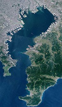
Tokyo Bay
Encyclopedia
Kanto region
The is a geographical area of Honshu, the largest island of Japan. The region includes the Greater Tokyo Area and encompasses seven prefectures: Gunma, Tochigi, Ibaraki, Saitama, Tokyo, Chiba, and Kanagawa. Within its boundaries, slightly more than 40 percent of the land area is the Kantō Plain....
of Japan
Japan
Japan is an island nation in East Asia. Located in the Pacific Ocean, it lies to the east of the Sea of Japan, China, North Korea, South Korea and Russia, stretching from the Sea of Okhotsk in the north to the East China Sea and Taiwan in the south...
. Its old name was .
Geography

Boso Peninsula
thumb|Locationthumb|Landsat image with high-resolution data from Space Shuttle is a peninsula in Chiba prefecture on Honshū, the largest island of Japan. It forms the eastern edge of Tokyo Bay, separating it from the Pacific Ocean....
(Chiba Prefecture
Chiba Prefecture
is a prefecture of Japan located in the Kantō region and the Greater Tokyo Area. Its capital is Chiba City.- History :Chiba Prefecture was established on June 15, 1873 with the merger of Kisarazu Prefecture and Inba Prefecture...
) to the east and the Miura Peninsula
Miura Peninsula
is a peninsula located in Kanagawa, Japan. It lies south of Yokohama and Tokyo and divides Tokyo Bay, to the east, from Sagami Bay, to the west. Cities and towns on the Miura Peninsula include Yokosuka, Miura, Hayama, Zushi, and Kamakura....
(Kanagawa Prefecture
Kanagawa Prefecture
is a prefecture located in the southern Kantō region of Japan. The capital is Yokohama. Kanagawa is part of the Greater Tokyo Area.-History:The prefecture has some archaeological sites going back to the Jōmon period...
) to the west. In a narrow sense, Tokyo Bay is the area north of the straight line formed by the on the Miura Peninsula on one end and on the Boso Peninsula on the other end. This area covers about 922 km². Tokyo Bay in a broad sense includes also the Uraga Channel
Uraga Channel
The is a waterway connecting Tokyo Bay to the Sagami Gulf. It is an important channel for ships headed from Tokyo, Yokohama, and Chiba to the Pacific Ocean and beyond.-Geography:...
. The total area would then be 1320 km².
Tokyo Bay includes about 249 km² of reclaimed land area.
The only natural island in the Bay is , Yokosuka, Kanagawa
Yokosuka, Kanagawa
is a city located in Kanagawa, Japan. As of 2010, the city had an estimated population of 419,067 and a population density of 4,160 people per km². It covered an area of 100.62 km²...
. There are however many artificial islands that were built as naval fortification during the Meiji
Meiji period
The , also known as the Meiji era, is a Japanese era which extended from September 1868 through July 1912. This period represents the first half of the Empire of Japan.- Meiji Restoration and the emperor :...
and Taishō period
Taisho period
The , or Taishō era, is a period in the history of Japan dating from July 30, 1912 to December 25, 1926, coinciding with the reign of the Taishō Emperor. The health of the new emperor was weak, which prompted the shift in political power from the old oligarchic group of elder statesmen to the Diet...
.
Islands
- Dream Island (Yume No Shima)Dream Island (Yume No Shima)is a district in Kōtō, Tokyo, Japan, consisting of an artificial island built using waste landfill.Construction started in the late 1950s as a potential solution to the garbage problem in the city of Tokyo....
- OdaibaOdaibais a large artificial island in Tokyo Bay, Japan, across the Rainbow Bridge from central Tokyo. It was initially built for defensive purposes in the 1850s, dramatically expanded during the late 20th century as a seaport district, and has developed since the 1990s as a major commercial, residential...
- SarushimaSarushimaSarushima , is a small island located in Yokosuka, Kanagawa. It is an an uninhabited natural island that can be visited by boat.* Area approximately 0.055km2* Circumference of 1.6km* Maximum height 39.3m* Near the preserved Battleship Mikasa...
(the only natural one) - Heiwa Island :ja:平和島
- Katsushima :ja:勝島
- Showa Island :ja:昭和島
- Keihin Island :ja:京浜島
- HakkeijimaYokohama Hakkeijima Sea Paradiseis an amusement park consisting of an aquarium, shopping mall, hotel, marina and amusement rides. It is located in Kanazawa-ku, Yokohama, Japan. It opened for business on May 8, 1993....
- Higashi Ogijima :ja:東扇島
- Tokyo International AirportTokyo International Airport, commonly known as , is one of the two primary airports that serve the Greater Tokyo Area in Japan. It is located in Ōta, Tokyo, south of Tokyo Station....
Development
The ports of TokyoTokyo
, ; officially , is one of the 47 prefectures of Japan. Tokyo is the capital of Japan, the center of the Greater Tokyo Area, and the largest metropolitan area of Japan. It is the seat of the Japanese government and the Imperial Palace, and the home of the Japanese Imperial Family...
, Chiba
Chiba, Chiba
is the capital city of Chiba Prefecture, Japan. It is located approximately 40 km east of the center of Tokyo on Tokyo Bay. Chiba City became a government designated city in 1992. Its population as of 2008 is approximately 960,000....
, Kawasaki
Kawasaki, Kanagawa
is a city located in Kanagawa Prefecture, Japan, between Tokyo and Yokohama. It is the 9th most populated city in Japan and one of the main cities forming the Greater Tokyo Area and Keihin Industrial Area....
, Yokohama
Port of Yokohama
The is operated by the Port and Harbor Bureau of the City of Yokohama in Japan. It opens onto Tokyo Bay. The port is located at a latitude of 35.27.–00°N and a longitude of 139.38–46°E. To the south lies the Port of Yokosuka; to the north, the ports of Kawasaki and Tokyo.-Facilities:Yokohama Port...
, and Yokosuka
Yokosuka, Kanagawa
is a city located in Kanagawa, Japan. As of 2010, the city had an estimated population of 419,067 and a population density of 4,160 people per km². It covered an area of 100.62 km²...
are all located on Tokyo Bay. The port of Yokosuka contains the naval bases of United States Forces Japan
United States Forces Japan
The refers to the various divisions of the United States Armed Forces that are stationed in Japan. Under the Treaty of Mutual Cooperation and Security between the United States and Japan, the United States is obliged to defend Japan in close cooperation with the Japan Self-Defense Forces for...
and the Japan Maritime Self-Defense Force
Japan Maritime Self-Defense Force
The , or JMSDF, is the naval branch of the Japan Self-Defense Forces, tasked with the naval defense of Japan. It was formed following the dissolution of the Imperial Japanese Navy after World War II....
.
On the western coast of Tokyo Bay, between Tokyo and Yokohama, the Keihin Industrial Area has been developed since the Meiji Era. This was expanded to the Keiyo Industrial Area along the north and east coasts after World War II
World War II
World War II, or the Second World War , was a global conflict lasting from 1939 to 1945, involving most of the world's nations—including all of the great powers—eventually forming two opposing military alliances: the Allies and the Axis...
.
The Tokyo Bay Aqua-Line
Tokyo Bay Aqua-Line
The , also known as the Trans-Tokyo Bay Highway, is a bridge-tunnel combination across Tokyo Bay in Japan.It connects the city of Kawasaki in Kanagawa Prefecture with the city of Kisarazu in Chiba Prefecture, and forms part of National Route 409...
bridge/tunnel crosses Tokyo Bay between Kawasaki
Kawasaki, Kanagawa
is a city located in Kanagawa Prefecture, Japan, between Tokyo and Yokohama. It is the 9th most populated city in Japan and one of the main cities forming the Greater Tokyo Area and Keihin Industrial Area....
and Kisarazu
Kisarazu, Chiba
is a city located in Chiba, Japan. As of September 2010, Kisarazu has an estimated population of 126,906 and a density of 915 persons per km². The total area was 138.73 km²....
; Tokyo-Wan Ferry
Tokyo-Wan Ferry
The is Japanese car ferry operator. Its line links Yokosuka, Kanagawa and Futtsu, Chiba, across Tokyo Bay in some 40 minutes. Headquartered in Yokosuka, the company started its service from 1957. The ferry started to accept PASMO smart cards from June 2008....
also crosses the bay toward the Uraga Channel
Uraga Channel
The is a waterway connecting Tokyo Bay to the Sagami Gulf. It is an important channel for ships headed from Tokyo, Yokohama, and Chiba to the Pacific Ocean and beyond.-Geography:...
between Kurihama (in Yokosuka) and Kanaya (in Futtsu
Futtsu, Chiba
is a city located in Chiba Prefecture, Japan. As of September 2010, the city had an estimated population of 47,705 and the population density of 232 persons per km²...
on the Chiba side).
History
Matthew Perry (naval officer)
Matthew Calbraith Perry was the Commodore of the U.S. Navy and served commanding a number of US naval ships. He served several wars, most notably in the Mexican-American War and the War of 1812. He played a leading role in the opening of Japan to the West with the Convention of Kanagawa in 1854...
's early negotiations with the Japanese bakufu
Tokugawa shogunate
The Tokugawa shogunate, also known as the and the , was a feudal regime of Japan established by Tokugawa Ieyasu and ruled by the shoguns of the Tokugawa family. This period is known as the Edo period and gets its name from the capital city, Edo, which is now called Tokyo, after the name was...
in the 1850s, as well as most official Japanese-European contacts preceding the Meiji Restoration
Meiji Restoration
The , also known as the Meiji Ishin, Revolution, Reform or Renewal, was a chain of events that restored imperial rule to Japan in 1868...
.
Shortly before the Japanese surrender in WWII there was a small naval surface action known as the Battle of Tokyo Bay
Battle of Tokyo Bay
The Battle of Sagami Bay was a World War II anti-shipping raid off tip of Bōsō Peninsula on the night of 22 July 1945. It was the last surface action of the war. Destroyer Squadron 61 of the U.S Navy engaged with a Japanese convoy consisting of two freighters and two Imperial Japanese Navy small...
.
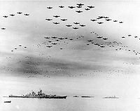
The Japanese Instrument of Surrender
Japanese Instrument of Surrender
The Japanese Instrument of Surrender was the written agreement that enabled the Surrender of Japan, marking the end of World War II. It was signed by representatives from the Empire of Japan, the United States of America, the Republic of China, the United Kingdom, the Union of Soviet Socialist...
at the end of World War II
World War II
World War II, or the Second World War , was a global conflict lasting from 1939 to 1945, involving most of the world's nations—including all of the great powers—eventually forming two opposing military alliances: the Allies and the Axis...
was signed onboard USS Missouri
USS Missouri (BB-63)
|USS Missouri is a United States Navy Iowa-class battleship, and was the fourth ship of the U.S. Navy to be named in honor of the U.S. state of Missouri...
moored in the Bay on 2 September 1945. During the ceremony a flag from one of Perry's ships was flown.
See also
- Uraga Harbor
- Miura PeninsulaMiura Peninsulais a peninsula located in Kanagawa, Japan. It lies south of Yokohama and Tokyo and divides Tokyo Bay, to the east, from Sagami Bay, to the west. Cities and towns on the Miura Peninsula include Yokosuka, Miura, Hayama, Zushi, and Kamakura....