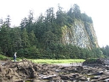
Tow Hill
Encyclopedia
Tow Hill is a large isolated volcanic plug
located 21 km (13 mi) east of Masset
on the north end of the Naikoon Peninsula of northeast Graham Island
in Haida Gwaii, British Columbia
, Canada
, east of McIntyre Bay and near the mouth of the Hiellen River
, which is the site of Hiellen a now-abandoned Haida village and of the Hiellen Indian Reserve No. 2, on the site of that village. Formerly Tow Hill Provincial Park, it is now part of Naikoon Provincial Park
, which covers most of the northeastern flatland of Graham Island.
Tow Hill is associated by the editors Canadian Mountain Encyclopedia with the Haida Gwaii Mountains which in turn form part of the Insular Mountains
, but it is not physically part of the range, and is separated from mountainous parts of Graham Island by expanses of forested flatland-marsh and is properly designated as being on the Argonaut Plain, one of the lowland areas of Haida Gwaii not in the Haida Gwaii Mountains.
Tow Hill consists of faceted columnar-jointed basalt
columns that solidified about two million years ago during the Pliocene
period.
Volcanic plug
A volcanic plug, also called a volcanic neck or lava neck, is a volcanic landform created when magma hardens within a vent on an active volcano. When forming, a plug can cause an extreme build-up of pressure if volatile-charged magma is trapped beneath it, and this can sometimes lead to an...
located 21 km (13 mi) east of Masset
Masset, British Columbia
Masset , formerly Massett, is a village in Haida Gwaii in British Columbia, Canada. It is located on the northern coast of Graham Island, the largest island in the archipelago, and is approximately west of mainland British Columbia. It is the western terminus of the Yellowhead Highway...
on the north end of the Naikoon Peninsula of northeast Graham Island
Graham Island
Graham Island is the largest island in the Haida Gwaii archipelago , lying off the coast of British Columbia, Canada. It is separated only by a narrow channel from the other principal island of the group, Moresby Island Graham Island is the largest island in the Haida Gwaii archipelago (formerly...
in Haida Gwaii, British Columbia
British Columbia
British Columbia is the westernmost of Canada's provinces and is known for its natural beauty, as reflected in its Latin motto, Splendor sine occasu . Its name was chosen by Queen Victoria in 1858...
, Canada
Canada
Canada is a North American country consisting of ten provinces and three territories. Located in the northern part of the continent, it extends from the Atlantic Ocean in the east to the Pacific Ocean in the west, and northward into the Arctic Ocean...
, east of McIntyre Bay and near the mouth of the Hiellen River
Hiellen River
The Hiellen River is a river on Graham Island in the Queen Charlotte Islands of British Columbia, Canada. It flows north into McIntyre Bay to the west of Tow Hill, and is entirely within Naikoon Provincial Park, which covers most of the peninsula of the same name. At the mouth of the Hiellen...
, which is the site of Hiellen a now-abandoned Haida village and of the Hiellen Indian Reserve No. 2, on the site of that village. Formerly Tow Hill Provincial Park, it is now part of Naikoon Provincial Park
Naikoon Provincial Park
Naikoon Provincial Park is a provincial park on Graham Island in the Haida Gwaii archipelago, British Columbia, Canada. It is the ancestral home of the Gwak'rala'chala people, one of the many tribes that form the native group Haida...
, which covers most of the northeastern flatland of Graham Island.
Tow Hill is associated by the editors Canadian Mountain Encyclopedia with the Haida Gwaii Mountains which in turn form part of the Insular Mountains
Insular Mountains
The Insular Mountains are a range of mountains in the Pacific Coast Ranges on the coast of British Columbia, Canada, comprising the Vancouver Island Ranges and Queen Charlotte Mountains. The Insular Mountains are rugged, particularly on Vancouver Island where peaks in Strathcona Provincial Park...
, but it is not physically part of the range, and is separated from mountainous parts of Graham Island by expanses of forested flatland-marsh and is properly designated as being on the Argonaut Plain, one of the lowland areas of Haida Gwaii not in the Haida Gwaii Mountains.
Tow Hill consists of faceted columnar-jointed basalt
Basalt
Basalt is a common extrusive volcanic rock. It is usually grey to black and fine-grained due to rapid cooling of lava at the surface of a planet. It may be porphyritic containing larger crystals in a fine matrix, or vesicular, or frothy scoria. Unweathered basalt is black or grey...
columns that solidified about two million years ago during the Pliocene
Pliocene
The Pliocene Epoch is the period in the geologic timescale that extends from 5.332 million to 2.588 million years before present. It is the second and youngest epoch of the Neogene Period in the Cenozoic Era. The Pliocene follows the Miocene Epoch and is followed by the Pleistocene Epoch...
period.
"This feature is an eroded volcanic plug - the most distinctive navigational landmark on the entire North Beach. Tow is derived from a Haida word that rhymes with "cow", and means place of food. Many legends about its' origin and the significance of the blowhole at the base of the hill......"

