
Transportation in Calgary
Encyclopedia
The city of Calgary, Alberta
, has a large transportation network that encompasses a variety of road, rail, air, public transit, and pedestrian infrastructure. Calgary is also a major Canadian transportation centre and a central cargo hub for freight in and out of north-western North America. The city sits at the junction between the "Canamex
" highway system and the Trans-Canada Highway
(Highway 1 in Alberta).
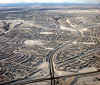
As a prairie city, Calgary has never had any major impediments to growth. As such, it has developed into a city with an area of about 745 km2 (of which only half is built up) and a metropolitan area of nearly 5 100 km2. This outward growth has encouraged the development of an extensive personal vehicle-oriented road network complete with a freeway system.
Since 1981, when the city officially opened the first leg of its CTrain
rapid transit
system, emphasis on public transportation as an alternative to cars has become important. The CTrain now has a higher ridership than any other light rail
system in any other North American city with 268 000 boardings per weekday. Cycling
is also seen as a major alternative to driving in Calgary. In recent years, increases in the population and density of inner city neighbourhoods such as the Beltline have favoured greater pedestrianism as well.
. The service operates only within Calgary city limits and does not provide transportation to and from other communities within the Calgary Region
. Some communities within Calgary's metropolitan area provide their own transit services (for example, Airdrie Transit
). Calgary Transit is owned and managed by the City of Calgary.
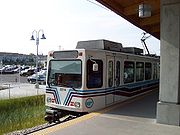 The light rail
transit (LRT) system, known as the C-Train
, consists of 48.8 km of track connecting 37 stations and was one of the first such systems in North America. Until very recently, Calgary and Edmonton were the only two North American cities with populations under one million to operate rapid mass transit systems. The McKnight-City Centre line serves downtown and the Northeast, while the Crowfoot-Somerset line runs between the Northwest and South Calgary via Downtown. Travel between stations along 7th Avenue in downtown is free-of-charge. Unique to the C-Train system, its power is completely wind generated and completely free of emissions.
 Calgary has an extensive street network. Smaller roads are supplemented with a number of major arteries, expressways
and freeways. The largest of these is the north-south running Deerfoot Trail
. The majority of main expressways and freeways are named Trails, as well as some of the main arterial roads that do not fit in the numbering grid. The use of the term Trails to describe major highways resulted from the development of early pioneer trails into the highways themselves. The original trails were named after the settlements to which they lead; for example, Edmonton Trail (part of the former Calgary and Edmonton Trail
), (Fort) Macleod Trail
, and Banff
Trail (which combined with 24th Street W was later renamed Crowchild Trail
). More recently developed local expressways were given the Trail moniker and have been named after important people from Calgary's history (Crowchild Trail, Marquis of Lorne Trail), native groups (Stoney Trail, Sarcee Trail, Blackfoot Trail) or again after their destination (Airport Trail).
Plans originating in the 1950s and 1960s for a considerably more extensive freeway system including elevated freeways were largely abandoned in favour of a growing trend to reduce the emphasis on roads and increase the amount public transportation infrastructure in North American cities.
Sidewalks at intersections in areas outside the downtown core are often stamped with the name of the cross-street, especially in older districts. As this was once done by hand by municipal employees who were not always literate, some street names are misspelled or the letters reversed.
 Traditionally Calgary's roads were built on a grid system. Originally, the streets and avenues were named, but after 1904, they were numbered. Today, numbered Streets (running north-south) and Avenues (running east-west) dominate the city, although names appear to be making a comeback. The city is divided into four quadrants: Northeast, Northwest, Southeast and Southwest, and all street names and addresses end with suffixes corresponding to the quadrant of the city in which they lie (NW, NE, SE or SW). The central point of the quadrant system is the Centre Street Bridge
, with Centre Street and Centre Avenue forming the boundaries (although the points vary; most of the south end has Macleod Trail as a boundary, except near Chinook Centre
where Macleod Trail bends westward; in the west end, the Bow River forms the boundary for the most part). Roads in predominantly suburban residential areas as well as freeways and expressways do not generally conform to the grid and are usually not numbered as a result (although some suburban streets are indeed numbered if they fall in place on the grid).
The main lines on the grid are fairly evenly distributed at intervals of about 1 mile (1.6 km) where an arterial road (or expressway) is usually situated (on former Township and Range Roads). They are at roughly the following Streets and Avenues (although not always named as such):
A quirk of the numbering is that it was intended for addresses on numbered streets to begin at 100 (not 0) at Centre Street and Centre Avenue and move out accordingly. For example, 545 16th Avenue NW lies between 4th and 5th Streets NW. There are many violations of such, however, especially in suburban areas. The highest address numbers are found on north-south streets in the southernmost suburbs, where they approach 20000.

 The city of Calgary designated major corridors to allow free flowing travel continuity throughout the city. With one exception (the central portion of 16th Avenue), they are all intended to be upgraded to freeways if they are not already.
Roads designated as north-south corridors, from east to west, are:
Roads designated as east-west corridors from south to north, are:
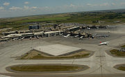
The Calgary International Airport
(ICAO Code CYYC, IATA Code YYC) is the only international airport in the Calgary Region
and one of only two in the province. The airport is WestJet Airlines
's main base and largest hub, and acts as an Air Canada
hub. In total, about 20 passenger airlines have regular scheduled flights to and from the airport. It is also a major hub for several cargo airlines including DHL
, FedEx
, Purolator
, and United Parcel Service
.
The airport primarily connects Western Canada
with non-stop flights to Eastern Canada
, 18 major American
cities, as well as sun destinations in the Caribbean and Mexico. Calgary International airport also has regular scheduled service to London, Frankfurt, Amsterdam, Mexico City and Tokyo.
Calgary International Airport is Canada's fourth busiest airport
in after Toronto Pearson International Airport
, Vancouver International Airport
and Montreal Trudeau International Airport
. In 2008, it served more than 12.5 million passengers.
Calgary's second airport, Calgary/Springbank Airport
, is located in the western suburb of Springbank, handles the majority of private-plane flights, and acts as a reliever for the main airport.
Schedule bus service from Calgary or Calgary Airport and north to Red Deer and Edmonton are provided by Greyhound, Red Arrow,and Ebus. Some departures pickup at the Calgary Airport. South to Lethbridge are Greyhound,the LA Shuttle and the Red Arrow. Calgary to Medicine Hat is provided by Greyhound and J&L Shuttle of Medicine Hat. Greyhound provides service west to British Columbia. Banff Airporter and Brewster provides service between the Calgary Airport and Banff. Brewster also provides service to Lake Louise and Jasper. Travel to Montana USA is a charter van service provided by Airport Shuttle Express of Calgary.
service to the city was terminated in the late 1980s and early 1990s by the Conservative government
. The Rocky Mountaineer
and Royal Canadian Pacific
rail tours serve Calgary from the former Via Rail station. Future rail investments could include:
, where many of these feeder lines connect to the main lines.
and jogging
). The dedicated pathway network in Calgary is among the most expansive in North America and spans 635 km. There are also about 290 km of signed on-street bicycle routes. The pathways connect many of the city's parks, river valley, residential neighbourhoods, and downtown. Even the airport
is on the pathway network. Calgarians make year-round use of these paths for walking, running, and cycling to various destinations. In June 2005, massive flooding destroyed much of the pathway system (including many pedestrian bridges) along the Elbow
and Bow
rivers. Most repairs are complete.
Calgary's system of elevated walkways or skyway
s downtown (known as the +15 system) is the most extensive in the world. These walkways not only serve to connect buildings, but also contain restaurants, shops, and services. The system is 16 km long.
Alberta
Alberta is a province of Canada. It had an estimated population of 3.7 million in 2010 making it the most populous of Canada's three prairie provinces...
, has a large transportation network that encompasses a variety of road, rail, air, public transit, and pedestrian infrastructure. Calgary is also a major Canadian transportation centre and a central cargo hub for freight in and out of north-western North America. The city sits at the junction between the "Canamex
CANAMEX Corridor
The CANAMEX corridor is a corridor linking Canada to Mexico through the United States. The corridor was established under the North American Free Trade Agreement.Currently the corridor is defined by a series of highways...
" highway system and the Trans-Canada Highway
Trans-Canada Highway
The Trans-Canada Highway is a federal-provincial highway system that joins the ten provinces of Canada. It is, along with the Trans-Siberian Highway and Australia's Highway 1, one of the world's longest national highways, with the main route spanning 8,030 km...
(Highway 1 in Alberta).
As a prairie city, Calgary has never had any major impediments to growth. As such, it has developed into a city with an area of about 745 km2 (of which only half is built up) and a metropolitan area of nearly 5 100 km2. This outward growth has encouraged the development of an extensive personal vehicle-oriented road network complete with a freeway system.
Since 1981, when the city officially opened the first leg of its CTrain
C-Train
C-Train is the light rail transit system in Calgary, Alberta, Canada. It has been in operation since May 25, 1981. The system is operated by Calgary Transit, a department of the Calgary municipal government.-Operations:...
rapid transit
Rapid transit
A rapid transit, underground, subway, elevated railway, metro or metropolitan railway system is an electric passenger railway in an urban area with a high capacity and frequency, and grade separation from other traffic. Rapid transit systems are typically located either in underground tunnels or on...
system, emphasis on public transportation as an alternative to cars has become important. The CTrain now has a higher ridership than any other light rail
Light rail
Light rail or light rail transit is a form of urban rail public transportation that generally has a lower capacity and lower speed than heavy rail and metro systems, but higher capacity and higher speed than traditional street-running tram systems...
system in any other North American city with 268 000 boardings per weekday. Cycling
Cycling
Cycling, also called bicycling or biking, is the use of bicycles for transport, recreation, or for sport. Persons engaged in cycling are cyclists or bicyclists...
is also seen as a major alternative to driving in Calgary. In recent years, increases in the population and density of inner city neighbourhoods such as the Beltline have favoured greater pedestrianism as well.
Public transportation
Calgary's primary public transportation system is operated by Calgary TransitCalgary Transit
Calgary Transit is the public transit service which is owned and operated by the city of Calgary, Alberta. In 2008, an estimated 95.3 million passengers boarded approximately 960 Calgary Transit vehicles , which thus provided 2.31 million hours of service .-History:What would eventually become...
. The service operates only within Calgary city limits and does not provide transportation to and from other communities within the Calgary Region
Calgary Region
The Calgary Region is an area centred around Calgary, Alberta, Canada. It consists of the City of Calgary, Rocky View County and the municipalities it encloses, and the Municipal District of Foothills No. 31 and the municipalities it encloses. The Calgary Census Metropolitan Area and Calgary...
. Some communities within Calgary's metropolitan area provide their own transit services (for example, Airdrie Transit
Airdrie Transit
Airdrie Transit is a public transportation system which serves the city of Airdrie, Alberta, Canada, which is located just north of Calgary within the Calgary–Edmonton Corridor. Service consists of the Intercity Express regional transit service, three conventional fixed routes within Airdrie and...
). Calgary Transit is owned and managed by the City of Calgary.
Light rail
Light rail
Light rail or light rail transit is a form of urban rail public transportation that generally has a lower capacity and lower speed than heavy rail and metro systems, but higher capacity and higher speed than traditional street-running tram systems...
transit (LRT) system, known as the C-Train
C-Train
C-Train is the light rail transit system in Calgary, Alberta, Canada. It has been in operation since May 25, 1981. The system is operated by Calgary Transit, a department of the Calgary municipal government.-Operations:...
, consists of 48.8 km of track connecting 37 stations and was one of the first such systems in North America. Until very recently, Calgary and Edmonton were the only two North American cities with populations under one million to operate rapid mass transit systems. The McKnight-City Centre line serves downtown and the Northeast, while the Crowfoot-Somerset line runs between the Northwest and South Calgary via Downtown. Travel between stations along 7th Avenue in downtown is free-of-charge. Unique to the C-Train system, its power is completely wind generated and completely free of emissions.
Buses
Calgary Transit also has a system of buses, with routes stretching over the whole city. It has won several awards for its efficiency and its environmental responsibility. It consists of over 160 bus routes and three C-Train lines (two routes), stretching over 4,500 km.Roads and streets
Limited-access road
A limited-access road known by various terms worldwide, including limited-access highway, dual-carriageway and expressway, is a highway or arterial road for high-speed traffic which has many or most characteristics of a controlled-access highway , including limited or no access to adjacent...
and freeways. The largest of these is the north-south running Deerfoot Trail
Deerfoot Trail
Deerfoot Trail is a freeway section of the Queen Elizabeth II Highway in Calgary, Alberta, Canada. It was formerly known as Blackfoot Trail Freeway, but was renamed to honour the first Native American to win the marathon....
. The majority of main expressways and freeways are named Trails, as well as some of the main arterial roads that do not fit in the numbering grid. The use of the term Trails to describe major highways resulted from the development of early pioneer trails into the highways themselves. The original trails were named after the settlements to which they lead; for example, Edmonton Trail (part of the former Calgary and Edmonton Trail
Calgary and Edmonton Trail
The Calgary and Edmonton Trail was a land transport route between Fort Edmonton and Fort Calgary in the Canadian Northwest.Several trails south from the fur trade post at Fort Edmonton had existed for some time...
), (Fort) Macleod Trail
Macleod Trail (Calgary)
Macleod Trail is a major road in Calgary, Alberta, Canada. It is a six to eight lane principal arterial road extending from downtown Calgary to the south of the city, where it merges into Highway 2. South of Anderson Road, Macleod Trail is an expressway and is slated to be upgraded to a freeway in...
, and Banff
Banff, Alberta
Banff is a town within Banff National Park in Alberta, Canada. It is located in Alberta's Rockies along the Trans-Canada Highway, approximately west of Calgary and east of Lake Louise....
Trail (which combined with 24th Street W was later renamed Crowchild Trail
Crowchild Trail
Crowchild Trail is an expressway located on the west side of Calgary, Alberta, Canada.The road was originally signed as 24th Street SW from North Glenmore Park to the Bow River, 24th Street NW from the Bow to the intersection with 16th Avenue NW , and Highway 1A from 16th Ave NW to the city limits...
). More recently developed local expressways were given the Trail moniker and have been named after important people from Calgary's history (Crowchild Trail, Marquis of Lorne Trail), native groups (Stoney Trail, Sarcee Trail, Blackfoot Trail) or again after their destination (Airport Trail).
Plans originating in the 1950s and 1960s for a considerably more extensive freeway system including elevated freeways were largely abandoned in favour of a growing trend to reduce the emphasis on roads and increase the amount public transportation infrastructure in North American cities.
Sidewalks at intersections in areas outside the downtown core are often stamped with the name of the cross-street, especially in older districts. As this was once done by hand by municipal employees who were not always literate, some street names are misspelled or the letters reversed.
Organization
Centre Street Bridge (Calgary)
The Centre Street Bridge is a bridge in Calgary, Alberta, crossing the Bow River, along the Centre Street. The lower deck connects Riverfront Avenue in Chinatown with Memorial Drive, while the upper elevated deck crosses Memorial Drive as well, reaching into the community of Crescent...
, with Centre Street and Centre Avenue forming the boundaries (although the points vary; most of the south end has Macleod Trail as a boundary, except near Chinook Centre
Chinook Centre
Chinook Centre is the largest enclosed shopping centre in Calgary, Alberta containing over 250 stores, a professional building, and a major theatre complex...
where Macleod Trail bends westward; in the west end, the Bow River forms the boundary for the most part). Roads in predominantly suburban residential areas as well as freeways and expressways do not generally conform to the grid and are usually not numbered as a result (although some suburban streets are indeed numbered if they fall in place on the grid).
The main lines on the grid are fairly evenly distributed at intervals of about 1 mile (1.6 km) where an arterial road (or expressway) is usually situated (on former Township and Range Roads). They are at roughly the following Streets and Avenues (although not always named as such):
- Avenues north of downtown: 16th, 32nd, 48th, 64th, 80th, 96th, 112th, 128th, 144th
- Avenues south of downtown: 17th, 34th, 50th, 66th, 82nd, 90th, 114th, 130th, 146th, 162nd, 178th, 194th
- Streets east of downtown: 6th, 15th, 24th, 36th, 52nd, 68th, 84th
- Streets west of downtown: 14th, 24th, 37th, 53rd, 69th, 85th, 101st, 117th
A quirk of the numbering is that it was intended for addresses on numbered streets to begin at 100 (not 0) at Centre Street and Centre Avenue and move out accordingly. For example, 545 16th Avenue NW lies between 4th and 5th Streets NW. There are many violations of such, however, especially in suburban areas. The highest address numbers are found on north-south streets in the southernmost suburbs, where they approach 20000.
Major streets
- 6th Avenue S / 9th Avenue S (Highway 1A - part)
- 14th Street W
- 16th Avenue N (Highway 1 / Trans-Canada Highway)
- 17th AvenueInternational Avenue, CalgaryInternational Avenue is a Business Revitalization Zone in Calgary, Alberta. The district is centered on 17th Avenue S.E. in the neighbourhood of Forest Lawn in the east of the city. The district was created in 1993 to celebrate the rich cultural diversity that exists in east central Calgary...
SE (Highway 1A - part) - 17th Avenue SW
- 36th Street E (Becomes Metis Trail north of McKnight Boulevard))
- 52nd Street E (Becomes Falconridge Boulevard north of McKnight Boulevard)
- Anderson Road
- Barlow Trail
- Blackfoot Trail
- Bow Trail
- Centre StreetCentre Street (Calgary)Centre Street is a major road in Calgary, Alberta.The northern part extends from the Bow River to Bergen Road/Beddington Drive, after which it becomes a local arterial street before it becomes unavailable to private vehicular traffic north of Bergen Crescent...
(Becomes Harvest Hills Boulevard north of Beddington Trail) - Country Hills Boulevard
- Crowchild TrailCrowchild TrailCrowchild Trail is an expressway located on the west side of Calgary, Alberta, Canada.The road was originally signed as 24th Street SW from North Glenmore Park to the Bow River, 24th Street NW from the Bow to the intersection with 16th Avenue NW , and Highway 1A from 16th Ave NW to the city limits...
(Highway 1A - part) - Deerfoot TrailDeerfoot TrailDeerfoot Trail is a freeway section of the Queen Elizabeth II Highway in Calgary, Alberta, Canada. It was formerly known as Blackfoot Trail Freeway, but was renamed to honour the first Native American to win the marathon....
(Queen Elizabeth II Highway / Highway 2) - Elbow Drive
- Glenmore Trail (Highway 8 - part)
- Heritage Drive
- John Laurie Boulevard
- Macleod TrailMacleod Trail (Calgary)Macleod Trail is a major road in Calgary, Alberta, Canada. It is a six to eight lane principal arterial road extending from downtown Calgary to the south of the city, where it merges into Highway 2. South of Anderson Road, Macleod Trail is an expressway and is slated to be upgraded to a freeway in...
(Highway 2A) - Marquis of Lorne Trail (Highway 22X)
- McKnight Boulevard
- Memorial DriveMemorial Drive (Calgary)Memorial Drive is a major road in Calgary, Alberta. Besides having an important role in city infrastructure, the tree lined sides of Memorial Drive serve as a living testament to the many soldiers who died during World War I and give it a parkway look on the western section...
- Sarcee Trail
- Stoney Trail (Highway 201)
Skeletal road network
Roads designated as north-south corridors, from east to west, are:
- the East Freeway
- Deerfoot TrailDeerfoot TrailDeerfoot Trail is a freeway section of the Queen Elizabeth II Highway in Calgary, Alberta, Canada. It was formerly known as Blackfoot Trail Freeway, but was renamed to honour the first Native American to win the marathon....
- Crowchild TrailCrowchild TrailCrowchild Trail is an expressway located on the west side of Calgary, Alberta, Canada.The road was originally signed as 24th Street SW from North Glenmore Park to the Bow River, 24th Street NW from the Bow to the intersection with 16th Avenue NW , and Highway 1A from 16th Ave NW to the city limits...
-Glenmore Trail-14th Street-Anderson Road-Macleod TrailMacleod Trail (Calgary)Macleod Trail is a major road in Calgary, Alberta, Canada. It is a six to eight lane principal arterial road extending from downtown Calgary to the south of the city, where it merges into Highway 2. South of Anderson Road, Macleod Trail is an expressway and is slated to be upgraded to a freeway in... - Stoney Trail-Highway 8-Glenmore Trail-Sarcee Trail.
Roads designated as east-west corridors from south to north, are:
- Marquis of Lorne Trail (Highway 22X)
- Highway 8-Glenmore Trail
- Trans-Canada HighwayTrans-Canada HighwayThe Trans-Canada Highway is a federal-provincial highway system that joins the ten provinces of Canada. It is, along with the Trans-Siberian Highway and Australia's Highway 1, one of the world's longest national highways, with the main route spanning 8,030 km...
(16th Avenue N) - Stoney Trail north.
Air
The Calgary International Airport
Calgary International Airport
Calgary International Airport, , is the international airport that serves Calgary, Alberta, Canada and the surrounding region; it is situated approximately northeast of downtown Calgary...
(ICAO Code CYYC, IATA Code YYC) is the only international airport in the Calgary Region
Calgary Region
The Calgary Region is an area centred around Calgary, Alberta, Canada. It consists of the City of Calgary, Rocky View County and the municipalities it encloses, and the Municipal District of Foothills No. 31 and the municipalities it encloses. The Calgary Census Metropolitan Area and Calgary...
and one of only two in the province. The airport is WestJet Airlines
WestJet
WestJet Airlines Ltd. is a Canadian low-cost carrier that provides scheduled and charter air service to 71 destinations in Canada, the United States, Mexico and the Caribbean. Founded in 1996, WestJet is currently the second largest Canadian air carrier, behind Air Canada, operating an average of...
's main base and largest hub, and acts as an Air Canada
Air Canada
Air Canada is the flag carrier and largest airline of Canada. The airline, founded in 1936, provides scheduled and charter air transport for passengers and cargo to 178 destinations worldwide. It is the world's tenth largest passenger airline by number of destinations, and the airline is a...
hub. In total, about 20 passenger airlines have regular scheduled flights to and from the airport. It is also a major hub for several cargo airlines including DHL
DHL
DHL Express is a division of the German logistics company Deutsche Post providing international express mail services. DHL is a world market leader in sea and air mail....
, FedEx
FedEx
FedEx Corporation , originally known as FDX Corporation, is a logistics services company, based in the United States with headquarters in Memphis, Tennessee...
, Purolator
Purolator Courier
Purolator Courier Ltd. is a Canadian courier that is 91% owned by Canada Post Corporation, 7% owned by Barry Lapointe Holdings Ltd. and 2% by others....
, and United Parcel Service
United Parcel Service
United Parcel Service, Inc. , typically referred to by the acronym UPS, is a package delivery company. Headquartered in Sandy Springs, Georgia, United States, UPS delivers more than 15 million packages a day to 6.1 million customers in more than 220 countries and territories around the...
.
The airport primarily connects Western Canada
Western Canada
Western Canada, also referred to as the Western provinces and commonly as the West, is a region of Canada that includes the four provinces west of the province of Ontario.- Provinces :...
with non-stop flights to Eastern Canada
Eastern Canada
Eastern Canada is generally considered to be the region of Canada east of Manitoba, consisting of the following provinces:* New Brunswick* Newfoundland and Labrador* Nova Scotia* Ontario* Prince Edward Island* Quebec...
, 18 major American
United States
The United States of America is a federal constitutional republic comprising fifty states and a federal district...
cities, as well as sun destinations in the Caribbean and Mexico. Calgary International airport also has regular scheduled service to London, Frankfurt, Amsterdam, Mexico City and Tokyo.
Calgary International Airport is Canada's fourth busiest airport
Canada's busiest airport
The following is a list of the busiest airports in Canada. The airports are ranked by passenger traffic and aircraft movements. For each airport, the lists cite the city served by the airport as designated by Transport Canada, not necessarily the municipality where the airport is physically...
in after Toronto Pearson International Airport
Toronto Pearson International Airport
Toronto Pearson International Airport is an international airport serving Toronto, Ontario, Canada; its metropolitan area; and the Golden Horseshoe, an urban agglomeration that is home to 8.1 million people – approximately 25% of Canada's population...
, Vancouver International Airport
Vancouver International Airport
Vancouver International Airport is located on Sea Island in Richmond, British Columbia, Canada, about from Downtown Vancouver. In 2010 it was the second busiest airport in Canada by aircraft movements and passengers , behind Toronto Pearson International Airport, with non-stop flights daily to...
and Montreal Trudeau International Airport
Montréal-Pierre Elliott Trudeau International Airport
Montréal-Pierre Elliott Trudeau International Airport or Montréal-Trudeau, formerly known as Montréal-Dorval International Airport, is located on the Island of Montreal, from Montreal's downtown core. The airport terminals are located entirely in Dorval, while the Air Canada headquarters complex...
. In 2008, it served more than 12.5 million passengers.
Calgary's second airport, Calgary/Springbank Airport
Calgary/Springbank Airport
Calgary/Springbank Airport or Springbank Airport, is an airport located in Springbank, Alberta, a large western suburb of Calgary, Alberta, Canada...
, is located in the western suburb of Springbank, handles the majority of private-plane flights, and acts as a reliever for the main airport.
Bus
Executive Express serves the Calgary-Edmonton corridor with a daily scheduled passenger transportation service aimed at the business commuter. Departing Calgary in the morning and returning to Calgary in the Afternoon, this is a unique service as passengers can either purchase seats or entire private compartments of four seats in the vehicle. This new concept allows business commuters to conduct meetings during travel time. Wireless internet among other ammenities is included. Travel time is just under 3 hours, within 15 minutes of an on time airline flight. Edmonton morning departures soon available.Schedule bus service from Calgary or Calgary Airport and north to Red Deer and Edmonton are provided by Greyhound, Red Arrow,and Ebus. Some departures pickup at the Calgary Airport. South to Lethbridge are Greyhound,the LA Shuttle and the Red Arrow. Calgary to Medicine Hat is provided by Greyhound and J&L Shuttle of Medicine Hat. Greyhound provides service west to British Columbia. Banff Airporter and Brewster provides service between the Calgary Airport and Banff. Brewster also provides service to Lake Louise and Jasper. Travel to Montana USA is a charter van service provided by Airport Shuttle Express of Calgary.
Passenger rail
Calgary is also the largest Canadian city without an Intercity Passenger Service, as all Via RailVIA Rail
Via Rail Canada is an independent crown corporation offering intercity passenger rail services in Canada. It is headquartered near Montreal Central Station at 3 Place Ville-Marie in Montreal, Quebec....
service to the city was terminated in the late 1980s and early 1990s by the Conservative government
Progressive Conservative Party of Canada
The Progressive Conservative Party of Canada was a Canadian political party with a centre-right stance on economic issues and, after the 1970s, a centrist stance on social issues....
. The Rocky Mountaineer
Rocky Mountaineer
Rocky Mountaineer is a Canadian tour company offering Western Canadian vacation packages that operates trains on four rail routes through British Columbia and Alberta.-Background:...
and Royal Canadian Pacific
Royal Canadian Pacific
The Royal Canadian Pacific is a luxury excursion passenger train operated by the Canadian Pacific Railway , inaugurated on June 7, 2000, after the CPR received the royal designation for the service from Elizabeth II, Queen of Canada....
rail tours serve Calgary from the former Via Rail station. Future rail investments could include:
- Future high speed rail
- Possible future commuter rail
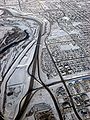
Freight
Calgary has four main Canadian Pacific and CN Rail lines that traverse the city, in addition to the various feeder lines that run through the industrial parks in the eastern half of the city. One of the rail structures in Calgary is the CPR Alyth YardCPR Alyth Yard
CPR Alyth Yard is a Class 1 railway facility located in the neighbourhood of Alyth, southeast of downtown Calgary, Alberta. One of Canadian Pacific Railway's main marshalling yards in Canada, it primarily serves as a hump classification yard and in addition has rail car repair shops and diesel...
, where many of these feeder lines connect to the main lines.
Bicycle and pedestrian
The City of Calgary also maintains a network of paved multi-use pathways (for bicycling, roller skatingRoller skating
Roller skating is the traveling on smooth surfaces with roller skates. It is a form of recreation as well as a sport, and can also be a form of transportation. Skates generally come in two basic varieties: quad roller skates and inline skates or blades, though some have experimented with a...
and jogging
Jogging
Jogging is a form of trotting or running at a slow or leisurely pace. The main intention is to increase fitness with less stress on the body than from faster running.-Definition:...
). The dedicated pathway network in Calgary is among the most expansive in North America and spans 635 km. There are also about 290 km of signed on-street bicycle routes. The pathways connect many of the city's parks, river valley, residential neighbourhoods, and downtown. Even the airport
Calgary International Airport
Calgary International Airport, , is the international airport that serves Calgary, Alberta, Canada and the surrounding region; it is situated approximately northeast of downtown Calgary...
is on the pathway network. Calgarians make year-round use of these paths for walking, running, and cycling to various destinations. In June 2005, massive flooding destroyed much of the pathway system (including many pedestrian bridges) along the Elbow
Elbow River
The Elbow River is a river located in southern Alberta, Canada. It flows from the Canadian Rockies to the city of Calgary, where it merges into the Bow River....
and Bow
Bow River
The Bow River is a river in the Canadian province of Alberta. It is a tributary of the South Saskatchewan River, and is considered the headwater of the Nelson River....
rivers. Most repairs are complete.
Calgary's system of elevated walkways or skyway
Skyway
In an urban setting, a skyway, catwalk, sky bridge, or skywalk is a type of pedway consisting of an enclosed or covered bridge between two buildings. This protects pedestrians from the weather. These skyways are usually owned by businesses, and are therefore not public spaces...
s downtown (known as the +15 system) is the most extensive in the world. These walkways not only serve to connect buildings, but also contain restaurants, shops, and services. The system is 16 km long.