

Trinity Niagara
Encyclopedia
Niagara is a neighbourhood in Toronto
, Ontario
, Canada
, located along and south of Queen Street West; it is usually bordered by Atlantic Avenue to the west, Bathurst Street to the east, and the railway corridor to the south, and so named because Niagara Street runs through the centre of it. The eastern portion of this area (with what is now called the Fashion District) was first planned as the New Town Extension when Toronto was incorporated as a city. The area was formerly working class, with many employed in industries located along the CN
and CP
railway corridors.
The ten block Town of York (later the St. Lawrence Ward
of the City of Toronto) was laid out by Governor Simcoe
in 1793 with its southern most street, Palace Street (now Front Street), following the shoreline to the west where it entered Fort York
on the west side of the Garrison Creek
This original town extended from Jarvis Street to Parliament Street (now Berkeley) with the rest of the area south of Lot Street (now Queen Street) as the 'Garrison Common' (open government land); north of Queen Street were 'farm lots'. North of about Palace Street (Front Street) and Crookshank Lane (Bathurst Street), a burial ground was established for the fort. Just before 1800 the town was extended with a 'New Town' (now the Financial District
) in the west using larger lots than in the 'Old Town' and extending from Jarvis Street to Peter Street.
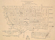
New Town Extension
 The 'New Town' grew slowly and it was not until the Town of York was incorporated as the City of Toronto in 1834 that the 'New Town' grid was extended from Peter Street to as far west as the Garrison Creek creating the 'New Town Extension' with its curved Niagara Street, later extended a block closer to the Garrison Creek with Walnut Street. The 'New Town Extension' was planned with a number of squares: Victoria Square
, Clarence Square
, McDonell Square and West Market Square. In the West Market Square, St. Andrew's Market was established to rival St. Lawrence Market in the 'Old Town' to the east. Between Victoria Square (including the former Garrison Burial Ground and the garrison chapel) at Bathurst Street and Clarence Square at Brock Street (Spadina Avenue) Wellington Street was planned as a broad 'Wellington Place', likely modelled after similar large boulevards in the planned
Capital of the United States, Washington
which had been burned during the War of 1812
in return for the American occupation of Toronto. Toronto was divided into 'wards' with much of the 'New Town Extension' in St. Andrew's Ward.
Early Development
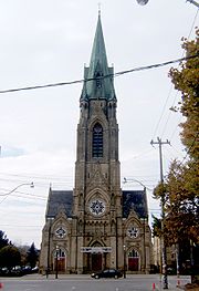
Toronto now extended horizontally from Niagara Street (with the Garrison Creek and Common beyond) to the Don River in the East, the area north of Queen having been planned as large estates. The areas in the extreme west ('New Town Extension') and east ('Corktown') remained largely undeveloped for some time and as poor relief programmes in Britain brought many poor and diseased to Toronto in the following years the empty lots in these areas quickly filled with poorly constructed housing and the land value deteriorated. Several Cholera and Typhoid outbreaks forced the City of Toronto to use these lots to house the sick. Many of the immigrants to this area were Irish Catholic and Toronto's first Catholic Church to serve the western part of the city was built in McDonell Square: St. Mary's Roman Catholic Church
. Most of Toronto's institutions and businesses preferred to remain closer to the central city in land subdivided from former 'Park Lots' north of Queen Street.
Later Residential and Industrial Development
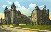 In the 1850s the railway reached Toronto from Hamilton cutting across the Garrison Common and by 1860, more of the Garrison Common west of the Garrison Creek and south of Queen street was subdivided around a 'Strachan Avenue' leading up to Bishop Strachan's Trinity College
. Some of the housing in the older St. Andrew's Ward was rebuilt. At the end of the 19th century Toronto carried out a large number of annexations and planned new grand institutional building north of Queen Street in St. John's Ward (now the Discovery District
), this led to the deterioration and demolition of many of Toronto's old institutional buildings south of Queen Street with many of the large lots being sold to the expanding Railways. Within the former 'New Town Extension', most of the area east of Bathurst Street and south of King Street, especially along 'Wellington Place' became industrial. In the first half of the 20th century many working families immigrated, especially from southern Europe (especially Italy and Portugal), to this neighbourhood. McDonell Square, the site of St. Mary's Roman Catholic Church, was renamed Portugal Square in recognition of the changing demographics.
Recent Redevelopment
In recent years, it has seen an explosion of new condominium
loft
and row house
development. The area is located close to the Fashion and Entertainment districts.
The area is also part of the Trinity—Spadina
riding
which covers a much larger section just west of the downtown core.
's 504 King streetcar, which with an average of 50,000 passengers per day is the busiest surface route in the city's system.
Toronto
Toronto is the provincial capital of Ontario and the largest city in Canada. It is located in Southern Ontario on the northwestern shore of Lake Ontario. A relatively modern city, Toronto's history dates back to the late-18th century, when its land was first purchased by the British monarchy from...
, Ontario
Ontario
Ontario is a province of Canada, located in east-central Canada. It is Canada's most populous province and second largest in total area. It is home to the nation's most populous city, Toronto, and the nation's capital, Ottawa....
, Canada
Canada
Canada is a North American country consisting of ten provinces and three territories. Located in the northern part of the continent, it extends from the Atlantic Ocean in the east to the Pacific Ocean in the west, and northward into the Arctic Ocean...
, located along and south of Queen Street West; it is usually bordered by Atlantic Avenue to the west, Bathurst Street to the east, and the railway corridor to the south, and so named because Niagara Street runs through the centre of it. The eastern portion of this area (with what is now called the Fashion District) was first planned as the New Town Extension when Toronto was incorporated as a city. The area was formerly working class, with many employed in industries located along the CN
Canadian National Railway
The Canadian National Railway Company is a Canadian Class I railway headquartered in Montreal, Quebec. CN's slogan is "North America's Railroad"....
and CP
Canadian Pacific Railway
The Canadian Pacific Railway , formerly also known as CP Rail between 1968 and 1996, is a historic Canadian Class I railway founded in 1881 and now operated by Canadian Pacific Railway Limited, which began operations as legal owner in a corporate restructuring in 2001...
railway corridors.
History
Garrison CommonThe ten block Town of York (later the St. Lawrence Ward
St. Lawrence, Toronto
St. Lawrence is a neighbourhood located in downtown Toronto, Ontario, Canada. The area, a former industrial area, is bounded by Yonge, Front, and Parliament Streets, and the Canadian National railway embankment. The Esplanade off Yonge St., lined with restaurants, cafés and hotels runs through the...
of the City of Toronto) was laid out by Governor Simcoe
John Graves Simcoe
John Graves Simcoe was a British army officer and the first Lieutenant Governor of Upper Canada from 1791–1796. Then frontier, this was modern-day southern Ontario and the watersheds of Georgian Bay and Lake Superior...
in 1793 with its southern most street, Palace Street (now Front Street), following the shoreline to the west where it entered Fort York
Fort York
Fort York is a historic site of military fortifications and related buildings on the west side of downtown Toronto, Ontario, Canada. The fort was built by the British Army and Canadian militia troops in the late 18th and early 19th centuries, to defend the settlement and the new capital of the...
on the west side of the Garrison Creek
Garrison Creek
Garrison Creek was a short stream about long that flowed southeast into the west side of Toronto Harbour in Ontario, Canada.It has been largely covered over and filled in, but geographical traces of the creek can still be found. The natural amphitheatre known as Christie Pits is one such remnant;...
This original town extended from Jarvis Street to Parliament Street (now Berkeley) with the rest of the area south of Lot Street (now Queen Street) as the 'Garrison Common' (open government land); north of Queen Street were 'farm lots'. North of about Palace Street (Front Street) and Crookshank Lane (Bathurst Street), a burial ground was established for the fort. Just before 1800 the town was extended with a 'New Town' (now the Financial District
Financial District, Toronto
The Financial District is a business district in Toronto, Ontario, Canada, within the downtown core. It was originally planned as New Town in 1796 as an extension of the Town of York . It is the main financial district in Toronto, and is the financial heart of Canada...
) in the west using larger lots than in the 'Old Town' and extending from Jarvis Street to Peter Street.
New Town Extension
Victoria Memorial Square
Victoria Memorial Square is a park and former cemetery in Toronto, Canada. Established in 1763 as the burial place for those affiliated with the nearby Fort York, it was the first cemetery to be used by European settlers in what would become the city of Toronto...
, Clarence Square
Clarence Square
Clarence Square is a small park in downtown Toronto where Wellington Street West meets Spadina Avenue. In the northwest corner of the park is a historical plaque honouring Alexander Dunn, born near the park, who was the first Canadian recipient of the Victoria Cross...
, McDonell Square and West Market Square. In the West Market Square, St. Andrew's Market was established to rival St. Lawrence Market in the 'Old Town' to the east. Between Victoria Square (including the former Garrison Burial Ground and the garrison chapel) at Bathurst Street and Clarence Square at Brock Street (Spadina Avenue) Wellington Street was planned as a broad 'Wellington Place', likely modelled after similar large boulevards in the planned
New Town
New Town may refer to:*New town, a generic name for a planned city development or expansion*In the United Kingdom, any of a specific set of towns created under various Acts of Parliament for population moved out of overcrowded conurbations-Places:...
Capital of the United States, Washington
Washington, D.C.
Washington, D.C., formally the District of Columbia and commonly referred to as Washington, "the District", or simply D.C., is the capital of the United States. On July 16, 1790, the United States Congress approved the creation of a permanent national capital as permitted by the U.S. Constitution....
which had been burned during the War of 1812
War of 1812
The War of 1812 was a military conflict fought between the forces of the United States of America and those of the British Empire. The Americans declared war in 1812 for several reasons, including trade restrictions because of Britain's ongoing war with France, impressment of American merchant...
in return for the American occupation of Toronto. Toronto was divided into 'wards' with much of the 'New Town Extension' in St. Andrew's Ward.
Early Development
Toronto now extended horizontally from Niagara Street (with the Garrison Creek and Common beyond) to the Don River in the East, the area north of Queen having been planned as large estates. The areas in the extreme west ('New Town Extension') and east ('Corktown') remained largely undeveloped for some time and as poor relief programmes in Britain brought many poor and diseased to Toronto in the following years the empty lots in these areas quickly filled with poorly constructed housing and the land value deteriorated. Several Cholera and Typhoid outbreaks forced the City of Toronto to use these lots to house the sick. Many of the immigrants to this area were Irish Catholic and Toronto's first Catholic Church to serve the western part of the city was built in McDonell Square: St. Mary's Roman Catholic Church
St. Mary's Church (Toronto)
St. Mary's Church is a Roman Catholic church located at 130 Bathurst Street at Portugal Square in the Niagara neighbourhood of Toronto's west end. The parish was established by Irish immigrants in 1852. The Gothic Revival church was designed by Joseph Connolly and completed in 1889, with the tower...
. Most of Toronto's institutions and businesses preferred to remain closer to the central city in land subdivided from former 'Park Lots' north of Queen Street.
Later Residential and Industrial Development
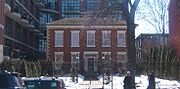
University of Trinity College
The University of Trinity College, informally referred to as Trin, is a college of the University of Toronto, founded in 1851 by Bishop John Strachan. Trinity was intended by Strachan as a college of strong Anglican alignment, after the University of Toronto severed its ties with the Church of...
. Some of the housing in the older St. Andrew's Ward was rebuilt. At the end of the 19th century Toronto carried out a large number of annexations and planned new grand institutional building north of Queen Street in St. John's Ward (now the Discovery District
Discovery District
The Discovery District is an area of downtown Toronto, Ontario, Canada, that features a high concentration of hospitals and research institutions, particularly those related to biotechnology...
), this led to the deterioration and demolition of many of Toronto's old institutional buildings south of Queen Street with many of the large lots being sold to the expanding Railways. Within the former 'New Town Extension', most of the area east of Bathurst Street and south of King Street, especially along 'Wellington Place' became industrial. In the first half of the 20th century many working families immigrated, especially from southern Europe (especially Italy and Portugal), to this neighbourhood. McDonell Square, the site of St. Mary's Roman Catholic Church, was renamed Portugal Square in recognition of the changing demographics.
Recent Redevelopment
In recent years, it has seen an explosion of new condominium
Condominium
A condominium, or condo, is the form of housing tenure and other real property where a specified part of a piece of real estate is individually owned while use of and access to common facilities in the piece such as hallways, heating system, elevators, exterior areas is executed under legal rights...
loft
Loft
A loft can be an upper story or attic in a building, directly under the roof. Alternatively, a loft apartment refers to large adaptable open space, often converted for residential use from some other use, often light industrial...
and row house
Terraced house
In architecture and city planning, a terrace house, terrace, row house, linked house or townhouse is a style of medium-density housing that originated in Great Britain in the late 17th century, where a row of identical or mirror-image houses share side walls...
development. The area is located close to the Fashion and Entertainment districts.
The area is also part of the Trinity—Spadina
Trinity—Spadina
Trinity—Spadina is a federal electoral district in Ontario, Canada, that has been represented in the Canadian House of Commons since 1988.It generally encompasses the western portion of Downtown Toronto. In the 2001 Canadian census, the riding had 106,094 people, of whom 74,409 were eligible to...
riding
Electoral district
An electoral district is a distinct territorial subdivision for holding a separate election for one or more seats in a legislative body...
which covers a much larger section just west of the downtown core.
Main streets
Some of the main roads in the neighbourhood include:- Bathurst Street
- Tecumseth Street
- King Street West
- Richmond Street West
- Adelaide Street West (Portugal Square - at Bathurst)
- Wellington Street West
- Niagara Street
Public transportation
Niagara is well served by public transit. King Street West is served by the Toronto Transit CommissionToronto Transit Commission
-Island Ferry:The ferry service to the Toronto Islands was operated by the TTC from 1927 until 1962, when it was transferred to the Metro Parks and Culture department. Since 1998, the ferry service is run by Toronto Parks and Recreation.-Gray Coach:...
's 504 King streetcar, which with an average of 50,000 passengers per day is the busiest surface route in the city's system.
Schools
- St. Mary Catholic School is a Roman Catholic elementary schoolElementary schoolAn elementary school or primary school is an institution where children receive the first stage of compulsory education known as elementary or primary education. Elementary school is the preferred term in some countries, particularly those in North America, where the terms grade school and grammar...
located at 20 Portugal Square. Founded in 1852 by the Sisters of St. Joseph and the Christian Brothers, it is one of the oldest parish schools in the City of Toronto. In 1918, the present old building was erected on Adelaide Street. In 1972, the newer section was opened. It offers education from Junior Kindergarten to Grade 8. - Niagara Street Junior Public School is a publicPublicIn public relations and communication science, publics are groups of individuals, and the public is the totality of such groupings. This is a different concept to the sociological concept of the Öffentlichkeit or public sphere. The concept of a public has also been defined in political science,...
elementary schoolElementary schoolAn elementary school or primary school is an institution where children receive the first stage of compulsory education known as elementary or primary education. Elementary school is the preferred term in some countries, particularly those in North America, where the terms grade school and grammar...
at the intersection of Adelaide Street West and Niagara Street. The original school was built in 1874. It is a small school providing Junior Kindergarten to Grade 6 education.