
.gif)
Tropical Storm Bilis (2006)
Encyclopedia
Severe Tropical Storm Bilis (international designation: 0604, JTWC
designation: 05W, designated Typhoon Florita by PAGASA
and sometimes known as just Tropical Storm Bilis) was a tropical storm that caused significant damage to areas of the Philippines
, Taiwan
, and southeastern China. It was the fifth tropical storm of the 2006 Pacific typhoon season
recognized by the Joint Typhoon Warning Center
. According to the Japan Meteorological Agency
, Bilis was the fourth tropical storm of the season. The storm was also designated a typhoon by PAGASA, though it was never officially designated as such by the JMA. The word Bilis, submitted by the Philippines
, means 'speed' or 'swiftness' in Tagalog
.
Despite never officially reaching typhoon strength, Bilis was responsible for $4.4 billion (2006 USD
) in damage and 859 fatalities in the Philippines, Taiwan, and China. Most of the damage was caused by heavy rain, which triggered widespread flash flood
ing and landslide
s. Many of the areas Bilis flooded were later affected by Typhoon Kaemi, Typhoon Prapiroon, and intense Typhoon Saomai
.
on July 7 and slowly increased in organization. The Joint Typhoon Warning Center
(JTWC) issued a Tropical Cyclone Formation Alert
on the disturbance later that day as it moved northwestward. By July 8, it had developed sufficient convection to be designated a tropical depression by the JTWC and the Japan Meteorological Agency
(JMA). The depression continued to strengthen, and was designated Tropical Storm Bilis by the JMA early on July 9. The JTWC upgraded Bilis to tropical storm status later that day. On July 10, Bilis moved into the area of responsibility of the Philippine Atmospheric, Geophysical and Astronomical Services Administration
(PAGASA), and was designated Tropical Storm Florita for local warnings.
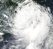
Over the next several days, Bilis moved generally northwestward toward Taiwan
, slowly strengthening over open waters. Bilis was designated a severe tropical storm by the JMA on July 11, but the storm did not strengthen much further over the next few days due to a marginal upper-air environment and dry air entrainment. PAGASA upgraded the system to typhoon status on July 12, but the JMA never officially recognized the system as such in its advisories. Bilis reached its official peak intensity of 60 knots (110 km/h, 70 mph) later that day.
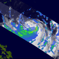
Bilis made its first landfall in northern Taiwan on July 13, with an intensity of 55 kt (100 km/h, 65 mph). After moving across northern Taiwan, Bilis made its second landfall in Fujian
, China early on July 14 at the same intensity, then weakened into a tropical depression over land the next day. Bilis lingered as a tropical depression over southeastern China before degenerating into a remnant low on July 16. Despite becoming a remnant low, the remnants of Bilis maintained their identity for several days while moving westward over China, bringing heavy rains to inland areas.
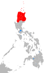 On July 13, PAGASA issued Storm Signal Number 3, a warning for winds of 100– 185 km/h (62– 115 mph), for the Batanes and Calayan Islands
. Storm Signal Number 2, for winds of 60– 100 km/h (37– 62 mph), was issued for northern Luzon
, including the rest of Cagayan
, Ilocos Norte
, and Apayao
. Storm Signal Number 1 (30– 60 km/h, 19– 37 mph) was raised for most of central Luzon, including much of the Cordillera Administrative Region
and the northern half of the Ilocos Region
. Schools and government offices in those regions were closed.
The provincial observatory of Fujian
issued a typhoon warning for the province on July 11, well in advance of Bilis' final landfall. In response to the warning, officials evacuated over 800,000 people from Hunan
and 70,000 from Zhejiang
. In addition, 256,000 fishermen and workers were evacuated from coastal areas in southeastern China, and 220,000 ships were ordered to return to port. In Shanghai
, the evacuations caused significant rail and bus delays, and more than 210 flights in and out of the city were canceled prior to landfall.
in the Philippines
, causing heavy rains, wind gusts to tropical storm force, flash flooding, and landslides. Bilis was responsible for 45 million pesos in damage and at least 14 deaths, including three in Baguio City
, and six more in the Manila
area.
, due to Bilis' quick movement across the northern coast of the island. The Republic of China
government reported four deaths, two of which were the deaths of fishermen from mainland China
whose boat ran aground on Matsu Island. Another man was electrocuted in the city of Taipei
as a result of the storm. The cause of the fourth death is unknown.
 The storm made its second landfall in Fujian
province, China, which was the province most impacted by the tropical cyclone. A total of 92 deaths and 3 billion Chinese yuan
in damage were caused by the system, mostly from flooding. Schools and tourist attractions in the province were closed for several days. A total of 4,028,000 people were affected over an area of 17597 square kilometre, and the storm caused the evacuation of 519,000 people from the province.
Flooding killed 39 people in eastern Guangxi
and 183 people in Guangdong
. Eight more people were killed in Yunnan
when a flash flood swept away some road workers' huts. A weather station in Guangdong reported a 5-hour rainfall total of 360.6 mm (14.2 inch
es). In Zhejiang
, strong winds and heavy rain from Bilis caused 694 million yuan in damage, and a wind gust to 43 m/s (155 km/h, 96 mph) was reported.
Several sections of the Beijing
-Guangzhou
railway, a main rail route in China, were blocked by flooding and landslides, causing many delays and diversions. One train was surrounded by floodwaters in Lechang
, and passengers had to be evacuated to a nearby school. At least 274 trains were affected and the train company refunded nearly 2 million tickets. After three days of repair work, the rail service resumed normal operations on July 18.
Significant damage occurred in Hunan
, where heavy flooding and mudslides destroyed over 31,000 homes and caused 526 deaths. Most of the damage and fatalities occurred in the village of Zixing
, where local officials reported the flooding as the worst the area had seen in the past 100 years, and described the death toll as "unprecedented". In all, Bilis was responsible for 843 deaths, 208 people reported missing, and $4.4 billion (2006 USD) in damage to southeastern China.
, as well as three more tropical cyclones: Typhoon Kaemi, Typhoon Prapiroon, and Typhoon Saomai
. All of the storms were stronger than Bilis, and exacerbated flooding and other problems in the region.
 Because of the sudden large increase in the number of reported deaths in Hunan in a matter of hours, Chinese government officials accused local officials of covering up damage and casualty details. The Ministry of Civil Affairs sent a team to Hunan to investigate the allegations, and issued a notice stating that anyone found to be covering up any damage details would be held accountable.
The China Meteorological Administration released a press release after the storm and gave four reasons for the extensive damage. First, the storm decelerated after landfall and maintained its identity for 120 hours while moving south of due west. Secondly, the storm was asymmetric and rainfall concentrated in the southern semicircle. Also, the storm interacted with the active monsoon over the South China Sea
, and the Hong Kong Observatory
reported a 1-hour rainfall total of 115.1 mm (4.5 inches), a new record. Finally, previous rainfall had made the area wetter than normal and more prone to flooding.
At the 39th annual meeting of the ESCAP/WMO Typhoon Committee in Manila
in December 2006, the name Bilis was retired, along with four other names. In December 2007, the committee selected the name Maliksi to replace Bilis on the Western Pacific basin name lists beginning in 2008
.
Joint Typhoon Warning Center
The Joint Typhoon Warning Center is a joint United States Navy – United States Air Force task force located at the Naval Maritime Forecast Center in Pearl Harbor, Hawaii...
designation: 05W, designated Typhoon Florita by PAGASA
Philippine Atmospheric, Geophysical and Astronomical Services Administration
The Philippine Atmospheric, Geophysical and Astronomical Services Administration is a Philippine national institution dedicated to provide flood and typhoon warnings, public weather forecasts and advisories, meteorological, astronomical, climatological, and other specialized information and...
and sometimes known as just Tropical Storm Bilis) was a tropical storm that caused significant damage to areas of the Philippines
Philippines
The Philippines , officially known as the Republic of the Philippines , is a country in Southeast Asia in the western Pacific Ocean. To its north across the Luzon Strait lies Taiwan. West across the South China Sea sits Vietnam...
, Taiwan
Taiwan
Taiwan , also known, especially in the past, as Formosa , is the largest island of the same-named island group of East Asia in the western Pacific Ocean and located off the southeastern coast of mainland China. The island forms over 99% of the current territory of the Republic of China following...
, and southeastern China. It was the fifth tropical storm of the 2006 Pacific typhoon season
2006 Pacific typhoon season
The 2006 Pacific typhoon season had no official bounds; it ran year-round in 2006, but most tropical cyclones tend to form in the northwestern Pacific Ocean between May and November...
recognized by the Joint Typhoon Warning Center
Joint Typhoon Warning Center
The Joint Typhoon Warning Center is a joint United States Navy – United States Air Force task force located at the Naval Maritime Forecast Center in Pearl Harbor, Hawaii...
. According to the Japan Meteorological Agency
Japan Meteorological Agency
The or JMA, is the Japanese government's weather service. Charged with gathering and reporting weather data and forecasts in Japan, it is a semi-autonomous part of the Ministry of Land, Infrastructure and Transport...
, Bilis was the fourth tropical storm of the season. The storm was also designated a typhoon by PAGASA, though it was never officially designated as such by the JMA. The word Bilis, submitted by the Philippines
Philippines
The Philippines , officially known as the Republic of the Philippines , is a country in Southeast Asia in the western Pacific Ocean. To its north across the Luzon Strait lies Taiwan. West across the South China Sea sits Vietnam...
, means 'speed' or 'swiftness' in Tagalog
Tagalog language
Tagalog is an Austronesian language spoken as a first language by a third of the population of the Philippines and as a second language by most of the rest. It is the first language of the Philippine region IV and of Metro Manila...
.
Despite never officially reaching typhoon strength, Bilis was responsible for $4.4 billion (2006 USD
United States dollar
The United States dollar , also referred to as the American dollar, is the official currency of the United States of America. It is divided into 100 smaller units called cents or pennies....
) in damage and 859 fatalities in the Philippines, Taiwan, and China. Most of the damage was caused by heavy rain, which triggered widespread flash flood
Flash flood
A flash flood is a rapid flooding of geomorphic low-lying areas—washes, rivers, dry lakes and basins. It may be caused by heavy rain associated with a storm, hurricane, or tropical storm or meltwater from ice or snow flowing over ice sheets or snowfields...
ing and landslide
Landslide
A landslide or landslip is a geological phenomenon which includes a wide range of ground movement, such as rockfalls, deep failure of slopes and shallow debris flows, which can occur in offshore, coastal and onshore environments...
s. Many of the areas Bilis flooded were later affected by Typhoon Kaemi, Typhoon Prapiroon, and intense Typhoon Saomai
Typhoon Saomai
The name Saomai has been used to name two tropical cyclones in the northwestern Pacific Ocean. The name is the Vietnamese name of the planet Venus .* 2000's Typhoon Saomai...
.
Meteorological history
A tropical disturbance developed northeast of YapYap
Yap, also known as Wa'ab by locals, is an island in the Caroline Islands of the western Pacific Ocean. It is a state of the Federated States of Micronesia. Yap's indigenous cultures and traditions are still strong compared to other neighboring islands. The island of Yap actually consists of four...
on July 7 and slowly increased in organization. The Joint Typhoon Warning Center
Joint Typhoon Warning Center
The Joint Typhoon Warning Center is a joint United States Navy – United States Air Force task force located at the Naval Maritime Forecast Center in Pearl Harbor, Hawaii...
(JTWC) issued a Tropical Cyclone Formation Alert
Tropical Cyclone Formation Alert
A Tropical Cyclone Formation Alert is a bulletin released by the U.S. Navy-operated Joint Typhoon Warning Center in Honolulu, Hawaii or the Naval Maritime Forecast Center in Norfolk, Virginia, warning of the possibility of a tropical cyclone forming from a tropical disturbance that has been...
on the disturbance later that day as it moved northwestward. By July 8, it had developed sufficient convection to be designated a tropical depression by the JTWC and the Japan Meteorological Agency
Japan Meteorological Agency
The or JMA, is the Japanese government's weather service. Charged with gathering and reporting weather data and forecasts in Japan, it is a semi-autonomous part of the Ministry of Land, Infrastructure and Transport...
(JMA). The depression continued to strengthen, and was designated Tropical Storm Bilis by the JMA early on July 9. The JTWC upgraded Bilis to tropical storm status later that day. On July 10, Bilis moved into the area of responsibility of the Philippine Atmospheric, Geophysical and Astronomical Services Administration
Philippine Atmospheric, Geophysical and Astronomical Services Administration
The Philippine Atmospheric, Geophysical and Astronomical Services Administration is a Philippine national institution dedicated to provide flood and typhoon warnings, public weather forecasts and advisories, meteorological, astronomical, climatological, and other specialized information and...
(PAGASA), and was designated Tropical Storm Florita for local warnings.
Over the next several days, Bilis moved generally northwestward toward Taiwan
Taiwan
Taiwan , also known, especially in the past, as Formosa , is the largest island of the same-named island group of East Asia in the western Pacific Ocean and located off the southeastern coast of mainland China. The island forms over 99% of the current territory of the Republic of China following...
, slowly strengthening over open waters. Bilis was designated a severe tropical storm by the JMA on July 11, but the storm did not strengthen much further over the next few days due to a marginal upper-air environment and dry air entrainment. PAGASA upgraded the system to typhoon status on July 12, but the JMA never officially recognized the system as such in its advisories. Bilis reached its official peak intensity of 60 knots (110 km/h, 70 mph) later that day.
Bilis made its first landfall in northern Taiwan on July 13, with an intensity of 55 kt (100 km/h, 65 mph). After moving across northern Taiwan, Bilis made its second landfall in Fujian
Fujian
' , formerly romanised as Fukien or Huguing or Foukien, is a province on the southeast coast of mainland China. Fujian is bordered by Zhejiang to the north, Jiangxi to the west, and Guangdong to the south. Taiwan lies to the east, across the Taiwan Strait...
, China early on July 14 at the same intensity, then weakened into a tropical depression over land the next day. Bilis lingered as a tropical depression over southeastern China before degenerating into a remnant low on July 16. Despite becoming a remnant low, the remnants of Bilis maintained their identity for several days while moving westward over China, bringing heavy rains to inland areas.
Preparations
Calayan, Cagayan
Calayan is a 3rd class municipality in the province of Cagayan, Philippines. According to the latest census, it has a population of 16,233 people in 2,654 households....
. Storm Signal Number 2, for winds of 60– 100 km/h (37– 62 mph), was issued for northern Luzon
Luzon
Luzon is the largest island in the Philippines. It is located in the northernmost region of the archipelago, and is also the name for one of the three primary island groups in the country centered on the Island of Luzon...
, including the rest of Cagayan
Cagayan
Cagayan , the "Land of Smiling Beauty", is a province of the Philippines in the Cagayan Valley region in Luzon. Its capital is Tuguegarao City and is located at the northeastern corner of the island of Luzon. Cagayan also includes the Babuyan Islands to the north. The province borders Ilocos Norte...
, Ilocos Norte
Ilocos Norte
Ilocos Norte is a province of the Philippines located in the Ilocos Region in Luzon. Its capital is Laoag City and is located at the northwest corner of Luzon Island, bordering Cagayan and Apayao to the east, and Abra and Ilocos Sur to the south...
, and Apayao
Apayao
Apayao is a landlocked province of the Philippines in the Cordillera Administrative Region in Luzon. Its administrative capital is Luna and founding capital Kabugao. It borders Cagayan to the north and east, Abra and Ilocos Norte to the west, and Kalinga to the south...
. Storm Signal Number 1 (30– 60 km/h, 19– 37 mph) was raised for most of central Luzon, including much of the Cordillera Administrative Region
Cordillera Administrative Region
The Cordillera Administrative Region is a region in the Philippines composed of the provinces of Abra, Apayao, Benguet, Ifugao, Kalinga and Mountain Province, as well as Baguio City, the regional center. The Cordillera Administrative Region encompasses most of the areas within the Cordillera...
and the northern half of the Ilocos Region
Ilocos Region
The Ilocos region or Region I is a Region of the Philippines and is located in the northwest of Luzon. It borders to the east the regions of the Cordillera Administrative Region and Cagayan Valley and to the south the region of Central Luzon...
. Schools and government offices in those regions were closed.
The provincial observatory of Fujian
Fujian
' , formerly romanised as Fukien or Huguing or Foukien, is a province on the southeast coast of mainland China. Fujian is bordered by Zhejiang to the north, Jiangxi to the west, and Guangdong to the south. Taiwan lies to the east, across the Taiwan Strait...
issued a typhoon warning for the province on July 11, well in advance of Bilis' final landfall. In response to the warning, officials evacuated over 800,000 people from Hunan
Hunan
' is a province of South-Central China, located to the south of the middle reaches of the Yangtze River and south of Lake Dongting...
and 70,000 from Zhejiang
Zhejiang
Zhejiang is an eastern coastal province of the People's Republic of China. The word Zhejiang was the old name of the Qiantang River, which passes through Hangzhou, the provincial capital...
. In addition, 256,000 fishermen and workers were evacuated from coastal areas in southeastern China, and 220,000 ships were ordered to return to port. In Shanghai
Shanghai
Shanghai is the largest city by population in China and the largest city proper in the world. It is one of the four province-level municipalities in the People's Republic of China, with a total population of over 23 million as of 2010...
, the evacuations caused significant rail and bus delays, and more than 210 flights in and out of the city were canceled prior to landfall.
Philippines
The strongest winds and heaviest rains were south and east of Bilis' center, and its outer rainbands swept across LuzonLuzon
Luzon is the largest island in the Philippines. It is located in the northernmost region of the archipelago, and is also the name for one of the three primary island groups in the country centered on the Island of Luzon...
in the Philippines
Philippines
The Philippines , officially known as the Republic of the Philippines , is a country in Southeast Asia in the western Pacific Ocean. To its north across the Luzon Strait lies Taiwan. West across the South China Sea sits Vietnam...
, causing heavy rains, wind gusts to tropical storm force, flash flooding, and landslides. Bilis was responsible for 45 million pesos in damage and at least 14 deaths, including three in Baguio City
Baguio City
The City of Baguio is a highly urbanized city in northern Luzon in the Philippines. Baguio City was established by Americans in 1900 at the site of an Ibaloi village known as Kafagway...
, and six more in the Manila
Manila
Manila is the capital of the Philippines. It is one of the sixteen cities forming Metro Manila.Manila is located on the eastern shores of Manila Bay and is bordered by Navotas and Caloocan to the north, Quezon City to the northeast, San Juan and Mandaluyong to the east, Makati on the southeast,...
area.
Taiwan
Damage was light in TaiwanTaiwan
Taiwan , also known, especially in the past, as Formosa , is the largest island of the same-named island group of East Asia in the western Pacific Ocean and located off the southeastern coast of mainland China. The island forms over 99% of the current territory of the Republic of China following...
, due to Bilis' quick movement across the northern coast of the island. The Republic of China
Republic of China
The Republic of China , commonly known as Taiwan , is a unitary sovereign state located in East Asia. Originally based in mainland China, the Republic of China currently governs the island of Taiwan , which forms over 99% of its current territory, as well as Penghu, Kinmen, Matsu and other minor...
government reported four deaths, two of which were the deaths of fishermen from mainland China
Mainland China
Mainland China, the Chinese mainland or simply the mainland, is a geopolitical term that refers to the area under the jurisdiction of the People's Republic of China . According to the Taipei-based Mainland Affairs Council, the term excludes the PRC Special Administrative Regions of Hong Kong and...
whose boat ran aground on Matsu Island. Another man was electrocuted in the city of Taipei
Taipei
Taipei City is the capital of the Republic of China and the central city of the largest metropolitan area of Taiwan. Situated at the northern tip of the island, Taipei is located on the Tamsui River, and is about 25 km southwest of Keelung, its port on the Pacific Ocean...
as a result of the storm. The cause of the fourth death is unknown.
People's Republic of China
Fujian
' , formerly romanised as Fukien or Huguing or Foukien, is a province on the southeast coast of mainland China. Fujian is bordered by Zhejiang to the north, Jiangxi to the west, and Guangdong to the south. Taiwan lies to the east, across the Taiwan Strait...
province, China, which was the province most impacted by the tropical cyclone. A total of 92 deaths and 3 billion Chinese yuan
Chinese yuan
The yuan is the base unit of a number of modern Chinese currencies. The yuan is the primary unit of account of the Renminbi.A yuán is also known colloquially as a kuài . One yuán is divided into 10 jiǎo or colloquially máo...
in damage were caused by the system, mostly from flooding. Schools and tourist attractions in the province were closed for several days. A total of 4,028,000 people were affected over an area of 17597 square kilometre, and the storm caused the evacuation of 519,000 people from the province.
Flooding killed 39 people in eastern Guangxi
Guangxi
Guangxi, formerly romanized Kwangsi, is a province of southern China along its border with Vietnam. In 1958, it became the Guangxi Zhuang Autonomous Region of the People's Republic of China, a region with special privileges created specifically for the Zhuang people.Guangxi's location, in...
and 183 people in Guangdong
Guangdong
Guangdong is a province on the South China Sea coast of the People's Republic of China. The province was previously often written with the alternative English name Kwangtung Province...
. Eight more people were killed in Yunnan
Yunnan
Yunnan is a province of the People's Republic of China, located in the far southwest of the country spanning approximately and with a population of 45.7 million . The capital of the province is Kunming. The province borders Burma, Laos, and Vietnam.Yunnan is situated in a mountainous area, with...
when a flash flood swept away some road workers' huts. A weather station in Guangdong reported a 5-hour rainfall total of 360.6 mm (14.2 inch
Inch
An inch is the name of a unit of length in a number of different systems, including Imperial units, and United States customary units. There are 36 inches in a yard and 12 inches in a foot...
es). In Zhejiang
Zhejiang
Zhejiang is an eastern coastal province of the People's Republic of China. The word Zhejiang was the old name of the Qiantang River, which passes through Hangzhou, the provincial capital...
, strong winds and heavy rain from Bilis caused 694 million yuan in damage, and a wind gust to 43 m/s (155 km/h, 96 mph) was reported.
Several sections of the Beijing
Beijing
Beijing , also known as Peking , is the capital of the People's Republic of China and one of the most populous cities in the world, with a population of 19,612,368 as of 2010. The city is the country's political, cultural, and educational center, and home to the headquarters for most of China's...
-Guangzhou
Guangzhou
Guangzhou , known historically as Canton or Kwangchow, is the capital and largest city of the Guangdong province in the People's Republic of China. Located in southern China on the Pearl River, about north-northwest of Hong Kong, Guangzhou is a key national transportation hub and trading port...
railway, a main rail route in China, were blocked by flooding and landslides, causing many delays and diversions. One train was surrounded by floodwaters in Lechang
Lechang
Lechang is a city in the northern Guangdong province, People's Republic of China, bordering Hunan province to the north. It is administratively a county-level city of Shaoguan City.-Administrative division:* Lecheng Jiedao...
, and passengers had to be evacuated to a nearby school. At least 274 trains were affected and the train company refunded nearly 2 million tickets. After three days of repair work, the rail service resumed normal operations on July 18.
Significant damage occurred in Hunan
Hunan
' is a province of South-Central China, located to the south of the middle reaches of the Yangtze River and south of Lake Dongting...
, where heavy flooding and mudslides destroyed over 31,000 homes and caused 526 deaths. Most of the damage and fatalities occurred in the village of Zixing
Zixing
Zixing is a city with more than 100,000 inhabitants in Chenzhou, Hunan, China. It is twinned with Laredo, Texas U.S....
, where local officials reported the flooding as the worst the area had seen in the past 100 years, and described the death toll as "unprecedented". In all, Bilis was responsible for 843 deaths, 208 people reported missing, and $4.4 billion (2006 USD) in damage to southeastern China.
Aftermath
Bilis and its associated flooding left over 400,000 people homeless, and over 2 million more had to be evacuated in the face of rising waters. Following the storm, the Red Cross Society of China provided food, blankets, and water purification kits to over 100,000 Hunan residents in mass evacuation shelters. The relief effort was complicated by an earthquake in YunnanYunnan
Yunnan is a province of the People's Republic of China, located in the far southwest of the country spanning approximately and with a population of 45.7 million . The capital of the province is Kunming. The province borders Burma, Laos, and Vietnam.Yunnan is situated in a mountainous area, with...
, as well as three more tropical cyclones: Typhoon Kaemi, Typhoon Prapiroon, and Typhoon Saomai
Typhoon Saomai
The name Saomai has been used to name two tropical cyclones in the northwestern Pacific Ocean. The name is the Vietnamese name of the planet Venus .* 2000's Typhoon Saomai...
. All of the storms were stronger than Bilis, and exacerbated flooding and other problems in the region.
The China Meteorological Administration released a press release after the storm and gave four reasons for the extensive damage. First, the storm decelerated after landfall and maintained its identity for 120 hours while moving south of due west. Secondly, the storm was asymmetric and rainfall concentrated in the southern semicircle. Also, the storm interacted with the active monsoon over the South China Sea
South China Sea
The South China Sea is a marginal sea that is part of the Pacific Ocean, encompassing an area from the Singapore and Malacca Straits to the Strait of Taiwan of around...
, and the Hong Kong Observatory
Hong Kong Observatory
Hong Kong Observatory is a department of the Hong Kong government. The Observatory forecasts weather and issues warnings on weather-related hazards...
reported a 1-hour rainfall total of 115.1 mm (4.5 inches), a new record. Finally, previous rainfall had made the area wetter than normal and more prone to flooding.
At the 39th annual meeting of the ESCAP/WMO Typhoon Committee in Manila
Manila
Manila is the capital of the Philippines. It is one of the sixteen cities forming Metro Manila.Manila is located on the eastern shores of Manila Bay and is bordered by Navotas and Caloocan to the north, Quezon City to the northeast, San Juan and Mandaluyong to the east, Makati on the southeast,...
in December 2006, the name Bilis was retired, along with four other names. In December 2007, the committee selected the name Maliksi to replace Bilis on the Western Pacific basin name lists beginning in 2008
2008 Pacific typhoon season
The 2008 Pacific typhoon season has no official bounds; it runs year-round in 2008, but most tropical cyclones tend to form in the northwestern Pacific Ocean between May and November...
.
See also
- China tropical cyclone rainfall climatologyChina tropical cyclone rainfall climatologyChina is a mountainous country, which leads to rapid dissipation of cyclones that move inland as well as significant amounts of rain from those dissipating cyclones. Typhoon Nina caused the collapse of two huge reservoirs and ten smaller dams when 1062 mm/41.81 inches fell in Henan...
- List of tropical cyclones
- Southern China Flood of 2006
- Timeline of the 2006 Pacific typhoon seasonTimeline of the 2006 Pacific typhoon seasonThe 2006 Pacific typhoon season had no official bounds; it ran year-round in 2006, but most tropical cyclones tend to form in the northwestern Pacific Ocean between June and December...
- Tropical cycloneTropical cycloneA tropical cyclone is a storm system characterized by a large low-pressure center and numerous thunderstorms that produce strong winds and heavy rain. Tropical cyclones strengthen when water evaporated from the ocean is released as the saturated air rises, resulting in condensation of water vapor...